開啟輔助訪問
 找回密碼
 立即加入

17L.Olga 短暫發展 登陸前轉化

簽到天數: 1650 天

[LV.Master]伴壇終老

2019-10-24 20:27 | 顯示全部樓層
  基本資料  
編號    :17 L
擾動編號日期:2019 10 24 19
撤編日期  :2019 10 00 00
97L INVEST 191024 1200 19.8N 93.8W ATL 25 NA

202124ij222lybbomrm2by.jpg

  NHC:30%    
1. Showers and thunderstorms associated with a broad area of low
pressure located over the Bay of Campeche have increased and are
showing some signs of organization, this morning.  This system has
the opportunity for some short-term development while it moves
northward before it merges with a cold front by late Friday.
* Formation chance through 48 hours...low...30 percent.
* Formation chance through 5 days...low...30 percent.[/quote]
two_atl_2d9.png two_atl_5d9.png


-MAX:35,1002

點評

對,可能是排版的時候不小心刪到經度93.8上的9,變成3.8W...已修正,多謝提醒~  發表於 2019-10-24 23:29
經度寫錯了,應該在19.8N,93.8W  發表於 2019-10-24 22:03

評分

參與人數 1水氣能量 +15 +1 收起 理由
t02436 + 15 + 1

查看全部評分

回復

使用道具 舉報

簽到天數: 1650 天

[LV.Master]伴壇終老

老農民版夜神月|2019-10-25 20:17 | 顯示全部樓層
NHC展望提升至High,70%/70%
1. Satellite imagery indicates that the circulation of the low
pressure system over the western Gulf of Mexico is becoming
better defined, and that the associated shower and thunderstorm
activity continues to show signs of organization.  It appears likely
that a short-lived tropical cyclone will form later today.  However,
the system is forecast to merge with a cold front and become
post-tropical tonight over the northwestern Gulf of Mexico.
Regardless of development, gale-force winds are expected behind the
cold front over the western Gulf of Mexico today and Saturday. For
more information, see High Seas Forecasts issued by the National
Weather Service.  An Air Force Reserve Hurricane Hunter aircraft is
scheduled to investigate the system later today, if necessary.
* Formation chance through 48 hours...high...70 percent.
* Formation chance through 5 days...high...70 percent.

two_atl_2d1025.png two_atl_5d1025.png

FWC-N發布TCFA
SUBJ/TROPICAL CYCLONE FORMATION ALERT//
RMKS/1. FORMATION OF A SIGNIFICANT TROPICAL CYCLONE IS POSSIBLE
WITHIN 100 NM EITHER SIDE OF A LINE FROM 21.0N 94.6W TO 24.3N 95.3W
WITHIN THE NEXT 24 HOURS. AVAILABLE DATA DOES NOT JUSTIFY
ISSUANCE OF NUMBERED TROPICAL CYCLONE WARNINGS AT THIS TIME.
WINDS IN THE AREA ARE ESTIMATED TO BE 20 TO 30 KNOTS. METSAT
IMAGERY AT 241800Z INDICATES THAT A CIRCULATION CENTER IS LOCATED
NEAR 20.9N 94.6W. THE SYSTEM IS MOVING NORTH-NORTHWESTWARD AT 08
KNOTS.
2. SATELLITE IMAGERY IS SHOWING AN ELONGATED AREA OF LOW PRESSURE IN
THE BAY OF CAMPECHE. SHOWERS AND THUNDERSTORMS ARE DEVELOPING IN
THE FORM OF CURVED CONVECTION BANDS AS THE STORM BECOMES MORE
ORGANIZED. IF THESE TRENDS CONTINUE, A SHORT LIVED TROPICAL
DEPRESSION MAY FORM BEFORE MERGING WITH A FRONTAL BOUNDARY.
3. THIS ALERT WILL BE REISSUED, UPGRADED TO WARNING OR CANCELLED
BY 251800Z.//
040006nb8wks88sj1j8vw6.gif


回復

使用道具 舉報

簽到天數: 1650 天

[LV.Master]伴壇終老

老農民版夜神月|2019-10-25 23:43 | 顯示全部樓層
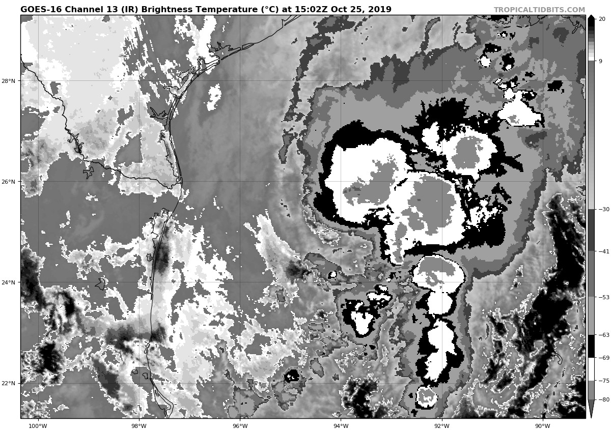
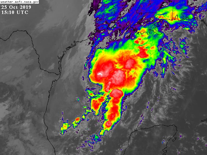
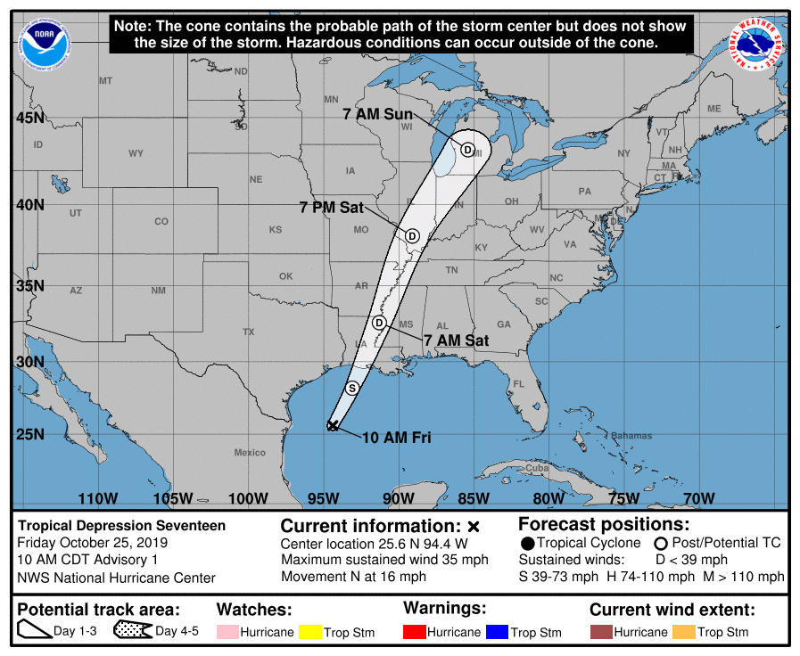
NHC25/15Z升格TD17L,預計將逐漸轉化
WTNT42 KNHC 251432
TCDAT2

Tropical Depression Seventeen Discussion Number   1
NWS National Hurricane Center Miami FL       AL172019
1000 AM CDT Fri Oct 25 2019

Satellite imagery indicates that the low pressure system in the
western Gulf of Mexico has developed a well-defined circulation.
In addition, a cluster of strong convection is located near and to
the northeast of the low-level center.  Thus, advisories are being
initiated on Tropical Depression Seventeen.  The initial intensity
is set at 30 kt, and it is possible based on last night's
scatterometer data that this is conservative.

A deep-layer baroclinic trough over the southern Plains states
should steer the cyclone north-northeastward with an increase in
forward speed during the next couple of days, with the center
crossing the northern Gulf coast tonight or Saturday morning.  The
track guidance is in good agreement, and the forecast track lies
close to the various consensus models.

A surface cold front associated with the baroclinic trough is
quickly approaching the center of the depression, and the tropical
cyclone is expected to merge with the front during the next 12 h.
Based on this, the cyclone is expected to become a gale-force
post-tropical low before it reaches the northern Gulf coast.  The
low should weaken after landfall, with dissipation expected just
after 48 h.  There is a chance that the system could briefly become
a tropical storm this afternoon before it merges with the cold
front.  However, even if this occurs it will make little difference
to the impacts on the northern Gulf coast.

Key messages:

1. Since depression is expected to merge with a cold front and
become post-tropical by tonight, hazards related to wind, rainfall
and coastal flooding will be covered by products issued by local
National Weather Service forecast offices, available at weather.gov


FORECAST POSITIONS AND MAX WINDS

INIT  25/1500Z 25.6N  94.4W   30 KT  35 MPH
12H  26/0000Z 28.2N  93.1W   35 KT  40 MPH...POST-TROP/EXTRATROP
24H  26/1200Z 32.6N  91.3W   30 KT  35 MPH...POST-TROP/EXTRATROP
36H  27/0000Z 38.1N  89.1W   25 KT  30 MPH...POST-TROP/EXTRATROP
48H  27/1200Z 43.2N  85.4W   20 KT  25 MPH...POST-TROP/EXTRATROP
72H  28/1200Z...DISSIPATED

$$
Forecaster Beven
143243_5day_cone_no_line_and_wind.png goes16_ir-dvorak_17L_201910251502.jpg
GOES15102019298BlWRlw.jpg


回復

使用道具 舉報

簽到天數: 3279 天

[LV.Master]伴壇終老

t02436|2019-10-26 12:52 | 顯示全部樓層
21Z報命名Olga,03Z報判定轉溫。
Tropical Storm Olga Discussion Number   2
NWS National Hurricane Center Miami FL       AL172019
400 PM CDT Fri Oct 25 2019

Although Tropical Depression Seventeen began looking less and less
like a tropical cyclone in satellite imagery, scatterometer data
and reports from an Air Force Reserve Hurricane Hunter aircraft
indicate that so far the tropical cyclone remains just ahead of the
approaching cold front, with the aircraft showing the front located
about 25 n mi from the center in the southwestern quadrant.  In
addition, the aircraft and scatterometer data indicate that the
cyclone's winds have increased to 35 kt in the northeastern
quadrant. Based on this, the depression is upgraded to Tropical
Storm Olga.  It should be noted that a large area of 35-45 kt winds
is occurring west of the cold front over the western Gulf of Mexico,
although these winds are more due to the cold air surging across the
Gulf than to the cyclone's circulation.

Olga has begun its expected acceleration toward the north-northeast
with the initial motion now 030/16. A deep-layer baroclinic trough
over the southern Plains states should steer the cyclone generally
north-northeastward with an additional increase in forward speed
during the next couple of days. The center is expected to cross the
northern Gulf coast tonight or Saturday morning and eventually reach
the eastern Great Lakes by late Sunday.  The new forecast track is
nudged a little to the east of the previous one based on the initial
position and motion through 36 h and an eastward shift in the
guidance at 48 h.

All indications are that Olga will complete extratropical transition
during the next few hours as it merges with the cold front.  The
intensity forecast shows slight strengthening during the first
12 h based on the premise that the winds west of the cold front
remain strong as they wrap into the circulation of Olga.  The
post-tropical low should weaken after landfall, and it is expected
to dissipate just after the 48-h point.

Key messages:

1. Since Olga is expected to merge with a cold front and become
post-tropical by tonight, hazards related to wind, rainfall and
coastal flooding will be covered by products issued by local
National Weather Service forecast offices, available at weather.gov

FORECAST POSITIONS AND MAX WINDS

INIT  25/2100Z 26.3N  93.2W   35 KT  40 MPH
12H  26/0600Z 29.8N  91.7W   40 KT  45 MPH...POST-TROP/EXTRATROP
24H  26/1800Z 35.2N  89.8W   30 KT  35 MPH...POST-TROP/EXTRATROP
36H  27/0600Z 40.1N  86.4W   25 KT  30 MPH...POST-TROP/EXTRATROP
48H  27/1800Z 44.5N  81.5W   25 KT  30 MPH...POST-TROP/EXTRATROP
72H  28/1800Z...DISSIPATED

$$
Forecaster Beven

203537_5day_cone_with_line_and_wind.png
Post-Tropical Cyclone Olga Discussion Number   3
NWS National Hurricane Center Miami FL       AL172019
1000 PM CDT Fri Oct 25 2019

Earlier this evening, the last 2 passes through Olga made by an Air
Force Reserve Hurricane Hunter aircraft showed that the cyclone
becoming embedded within a cold front. Strong northwesterly flow was
observed within 10 n mi northwest of Olga's center and a sharp
temperature and dew point gradient was measured across the cyclone.
It does not appear that Olga has separated from the front in any
significant way since the plane left. In fact, recent surface
observations suggest that either the front passes through the center
of the cyclone or its circulation has become poorly defined. Based
on all these data, Olga is now classified as post-tropical and this
is the last NHC advisory.
...

FORECAST POSITIONS AND MAX WINDS

INIT  26/0300Z 27.8N  92.2W   45 KT  50 MPH...POST-TROPICAL
12H  26/1200Z 31.8N  90.4W   35 KT  40 MPH...POST-TROP/EXTRATROP
24H  27/0000Z 38.0N  88.5W   30 KT  35 MPH...POST-TROP/EXTRATROP
36H  27/1200Z 43.5N  83.5W   30 KT  35 MPH...POST-TROP/EXTRATROP
48H  28/0000Z...DISSIPATED

GOES04462019299jTHHpR.jpg
回復

使用道具 舉報

快速回覆
您需要登錄後才可以回帖 登錄 | 立即加入

本版積分規則

本平台僅供學術討論之用,預報應以氣象局為準

威普網站虛擬主機贊助公司

臺灣第一個天氣類型社群平台 即時天氣資訊、精準颱風動態

線上客服
FB傳送訊息
廣告行銷
精準行銷 物超所值
官方粉專
發佈 快速回復 返回頂部 返回列表