開啟輔助訪問
 找回密碼
 立即加入

01E 東太紀錄上最早生成TC

簽到天數: 1650 天

[LV.Master]伴壇終老

2020-4-23 21:42 | 顯示全部樓層
  基本資料  
編號    :01 E
擾動編號日期:2020 04 23 21
撤編日期  :2020 04 28 02
90E INVEST 200423 1200 10.0N 111.0W EPAC 15 NA

212054cloxxighp5mr3gls.jpg

巔峰強度:30KT/1006hPa

評分

參與人數 1水氣能量 +15 +1 收起 理由
周子堯@FB + 15 + 1 熱帶擾動首帖

查看全部評分

回復

使用道具 舉報

簽到天數: 1650 天

[LV.Master]伴壇終老

老農民版夜神月|2020-4-23 22:34 | 顯示全部樓層
本帖最後由 老農民版夜神月 於 2020-4-23 22:38 編輯

NHC開始對90E做出系統展望,30%/40%
1. 1. A large area of disturbed weather associated with a trough of
low pressure has formed several hundred miles south of the
southern tip of the Baja California peninsula. Environmental
conditions are favorable for some gradual development for the next
couple of days as the disturbance moves slowly northwestward. By
late this weekend, conditions will become less conducive for
development. The next Special Tropical Weather Outlook on this
system will be issued by 2 PM PDT Friday, or earlier, if necessary.
* Formation chance through 48 hours...low...30 percent.
* Formation chance through 5 days...medium...40 percent.

two_pac_2d0.png two_pac_2d1.png
two_pac_5d1.png
回復

使用道具 舉報

簽到天數: 1650 天

[LV.Master]伴壇終老

老農民版夜神月|2020-4-24 09:50 | 顯示全部樓層
NHC展望提升至Medium,50%/50%,此系統若獲得升格將是東太史上最早生成的TC
1. Shower and thunderstorm activity has become a little better
organized today in association with a broad area of low pressure
located about 900 miles south-southwest of the southern tip of the
Baja California Peninsula. Environmental conditions are favorable
for some gradual development, and a tropical depression could form
in the next day or two as the system moves slowly northwestward. By
late this weekend, conditions will become less conducive for
development. The next Special Tropical Weather Outlook on this
system will be issued by 8 AM PDT Friday, or earlier, if necessary.
* Formation chance through 48 hours...medium...50 percent.
* Formation chance through 5 days...medium...50 percent.
two_pac_2d0.png two_pac_2d1.png
two_pac_5d1.png goes16_ir_90E_202004232315.jpg
回復

使用道具 舉報

簽到天數: 1650 天

[LV.Master]伴壇終老

老農民版夜神月|2020-4-24 16:53 | 顯示全部樓層
本帖最後由 老農民版夜神月 於 2020-4-24 21:32 編輯

JTWC於24/0900Z對90E發布TCFA,NHC展望亦已提升至80%/80%
WTPN21 PHNC 240900
MSGID/GENADMIN/JOINT TYPHOON WRNCEN PEARL HARBOR HI//
SUBJ/TROPICAL CYCLONE FORMATION ALERT (INVEST 90E)//
RMKS/
1. FORMATION OF A SIGNIFICANT TROPICAL CYCLONE IS POSSIBLE WITHIN
160 NM EITHER SIDE OF A LINE FROM 10.6N 113.3W TO 14.9N 116.8W
WITHIN THE NEXT 12 TO 24 HOURS. AVAILABLE DATA DOES NOT JUSTIFY
ISSUANCE OF NUMBERED TROPICAL CYCLONE WARNINGS AT THIS TIME.
WINDS IN THE AREA ARE ESTIMATED TO BE 20 TO 25 KNOTS. METSAT
IMAGERY AT 240600Z INDICATES THAT A CIRCULATION CENTER IS LOCATED
NEAR 11.0N 113.6W. THE SYSTEM IS MOVING NORTHWESTWARD AT 04
KNOTS.
2. REMARKS: AN AREA OF CONVECTION (INVEST 90E) HAS PERSISTED NEAR
13.0N 113.6W, APPROXIMATELY 738NM SOUTH-SOUTHWEST OF CABO SAN LUCAS,
MEXICO. ANIMATED MULTISPECTRAL SATELLITE IMAGERY DEPICTS WEAK,
FRAGMENTED BANDING WRAPPING INTO AN ELONGATED LOW-LEVEL CIRCULATION.
A 240318Z ASCAT PASS SHOWS 20-25 KNOT WINDS WRAPPING INTO AN
ELONGATED CIRCULATION. UPPER-LEVEL ANALYSIS INDICATES A FAVORABLE
ENVIRONMENT WITH LOW (<15 KNOTS) VERTICAL WIND SHEAR, GOOD OUTFLOW,
AND WARM (28-29C) SEA SURFACE TEMPERATURES. GLOBAL MODELS ARE IN
GOOD AGREEMENT THAT 90E TRACK NORTHWESTWARD OVER THE NEXT 24 HOURS.
MAXIMUM SUSTAINED SURFACE WINDS ARE ESTIMATED AT 20 TO 25 KNOTS.
MINIMUM SEA LEVEL PRESSURE IS ESTIMATED TO BE NEAR 1005 MB. THE
POTENTIAL FOR THE DEVELOPMENT OF A SIGNIFICANT TROPICAL CYCLONE
WITHIN THE NEXT 24 HOURS IS HIGH.
3. THIS ALERT WILL BE REISSUED, UPGRADED TO WARNING OR CANCELLED BY
250900Z.//
NNNN
ep9020.gif 90E_240900sair.jpg
two_pac_2d1.png two_pac_5d1.png
goes16_ir_90E.gif

回復

使用道具 舉報

簽到天數: 1650 天

[LV.Master]伴壇終老

老農民版夜神月|2020-4-25 21:28 | 顯示全部樓層
本帖最後由 老農民版夜神月 於 2020-4-25 22:34 編輯

相較於昨日環流明顯緊縮且對流減少,25/0900Z維持TCFA
WTPN21 PHNC 250900
MSGID/GENADMIN/JOINT TYPHOON WRNCEN PEARL HARBOR HI//
SUBJ/TROPICAL CYCLONE FORMATION ALERT (INVEST 90E) REISSUED//
REF/A/JOINT TYPHOON WRNCEN PEARL HARBOR HI/240851ZAPR2020//
AMPN/REF A IS TROPICAL CYCLONE FORMATION ALERT (WTPN21 PHNC 240900)//
RMKS/
1. FORMATION OF A SIGNIFICANT TROPICAL CYCLONE IS POSSIBLE WITHIN
140 NM EITHER SIDE OF A LINE FROM 13.2N 115.1W TO 16.9N 119.6W
WITHIN THE NEXT 12 TO 24 HOURS. AVAILABLE DATA DOES NOT JUSTIFY
ISSUANCE OF NUMBERED TROPICAL CYCLONE WARNINGS AT THIS TIME.
WINDS IN THE AREA ARE ESTIMATED TO BE 20 TO 25 KNOTS. METSAT
IMAGERY AT 250600Z INDICATES THAT A CIRCULATION CENTER IS LOCATED
NEAR 13.4N 115.3W. THE SYSTEM IS MOVING NORTH-NORTHWESTWARD AT 05
KNOTS.
2. REMARKS: AN AREA OF CONVECTION (INVEST 90E) PREVIOUSLY LOCATED
NEAR 11.0N 113.6W IS NOW LOCATED NEAR 13.4N 115.3W, APPROXIMATELY
640NM SOUTHWEST OF CABO SAN LUCAS, MEXICO. ANIMATED MULTISPECTRAL
SATELLITE IMAGERY DEPICTS FLARING CONVECTION OVER A PARTIALLY
EXPOSED LOW-LEVEL CIRCULATION. A 250442Z ASCAT-B PASS SHOWS 20-25
KNOT WINDS IN THE NORTHWESTERN QUADRANT. UPPER-LEVEL ANALYSIS
INDICATES A FAVORABLE ENVIRONMENT WITH LOW (<15 KNOTS) VERTICAL WIND
SHEAR, GOOD EQUATORWARD OUTFLOW, AND WARM (28-29C) SEA SURFACE
TEMPERATURES. GLOBAL MODELS ARE IN GENERAL AGREEMENT THAT INVEST 90E
WILL TRACK NORTHWESTWARD OVER THE NEXT 24 HOURS. MAXIMUM SUSTAINED
SURFACE WINDS ARE ESTIMATED AT 20 TO 25 KNOTS. MINIMUM SEA LEVEL
PRESSURE IS ESTIMATED TO BE NEAR 1007 MB. THE POTENTIAL FOR THE
DEVELOPMENT OF A SIGNIFICANT TROPICAL CYCLONE WITHIN THE NEXT 24
HOURS REMAINS HIGH. THIS SUPERSEDES REF A (WTPN21 PHNC 240900).
3. THIS ALERT WILL BE REISSUED, UPGRADED TO WARNING OR CANCELLED BY
260900Z.//
NNNN

ep9020.gif 90E_250900.jpg
90E_gefs_latest.png 90E_intensity_latest.png
回復

使用道具 舉報

簽到天數: 1650 天

[LV.Master]伴壇終老

老農民版夜神月|2020-4-25 23:36 | 顯示全部樓層
NHC25/15Z將90E升格為TD01E,此系統成為1966年衛星年代以來,最早生成的東北太平洋熱帶氣旋
000
WTPZ41 KNHC 251448
TCDEP1

Tropical Depression One-E Discussion Number   1
NWS National Hurricane Center Miami FL       EP012020
800 AM PDT Sat Apr 25 2020

Overnight ASCAT data showed the disturbance over the central eastern
Pacific basin has developed a well-defined center.  Furthermore,
convection associated with the low has increased in organization
since yesterday.  Advisories have therefore been initiated on
Tropical Depression One-E.  The initial intensity is set at 30 kt
based primarily on the aforementioned ASCAT data.  This marks
the earliest formation of a tropical cyclone in the eastern North
Pacific basin since the satellite era began in 1966.

The depression is not expected to stick around for long.  Dry air in
the surrounding environment appears to have already wrapped around
much of the cyclone's circulation, and this is likely limiting its
associated convection.  This should also prevent the depression from
strengthening much during the next 24 h, but it can not be ruled out
that the system could briefly become a tropical storm later today.
On Sunday, an increase in vertical wind shear and lower SSTs along
the forecast track will contribute to the depression's demise, and
it is expected to become a remnant low within about 36 h, if not
sooner.

The initial motion estimate is northwest at 6 kt.  The depression
should continue on a general northwestward heading for another day
or so until it becomes a remnant low.  The remnants should then turn
westward with the low-level trade wind flow until it dissipates
entirely in a couple of days.


FORECAST POSITIONS AND MAX WINDS

INIT  25/1500Z 14.1N 116.1W   30 KT  35 MPH
12H  26/0000Z 14.9N 116.8W   30 KT  35 MPH
24H  26/1200Z 15.9N 118.1W   30 KT  35 MPH
36H  27/0000Z 16.7N 119.8W   25 KT  30 MPH...POST-TROP/REMNT LOW
48H  27/1200Z 17.1N 121.7W   25 KT  30 MPH...POST-TROP/REMNT LOW
72H  28/1200Z...DISSIPATED

$$
Forecaster Zelinsky
144726_5day_cone_no_line_and_wind.png 20200425.1450.goes-17.vis.2km.01E.ONE.30kts.1006mb.13.9N.115.8W.pc.jpg
20200425.1256.f18.composite.90E.INVEST.30kts.1006mb.13.9N.115.8W.090pc.jpg goes16_vis-swir_90E.gif
goes16_ir_90E.gif


回復

使用道具 舉報

簽到天數: 1650 天

[LV.Master]伴壇終老

老農民版夜神月|2020-4-27 08:31 | 顯示全部樓層
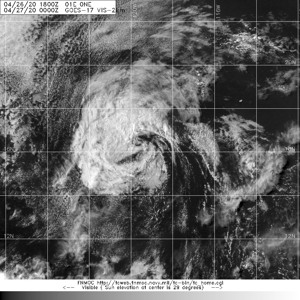
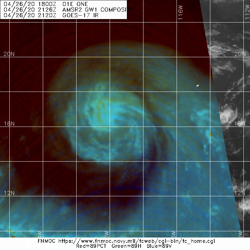
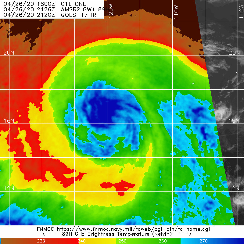
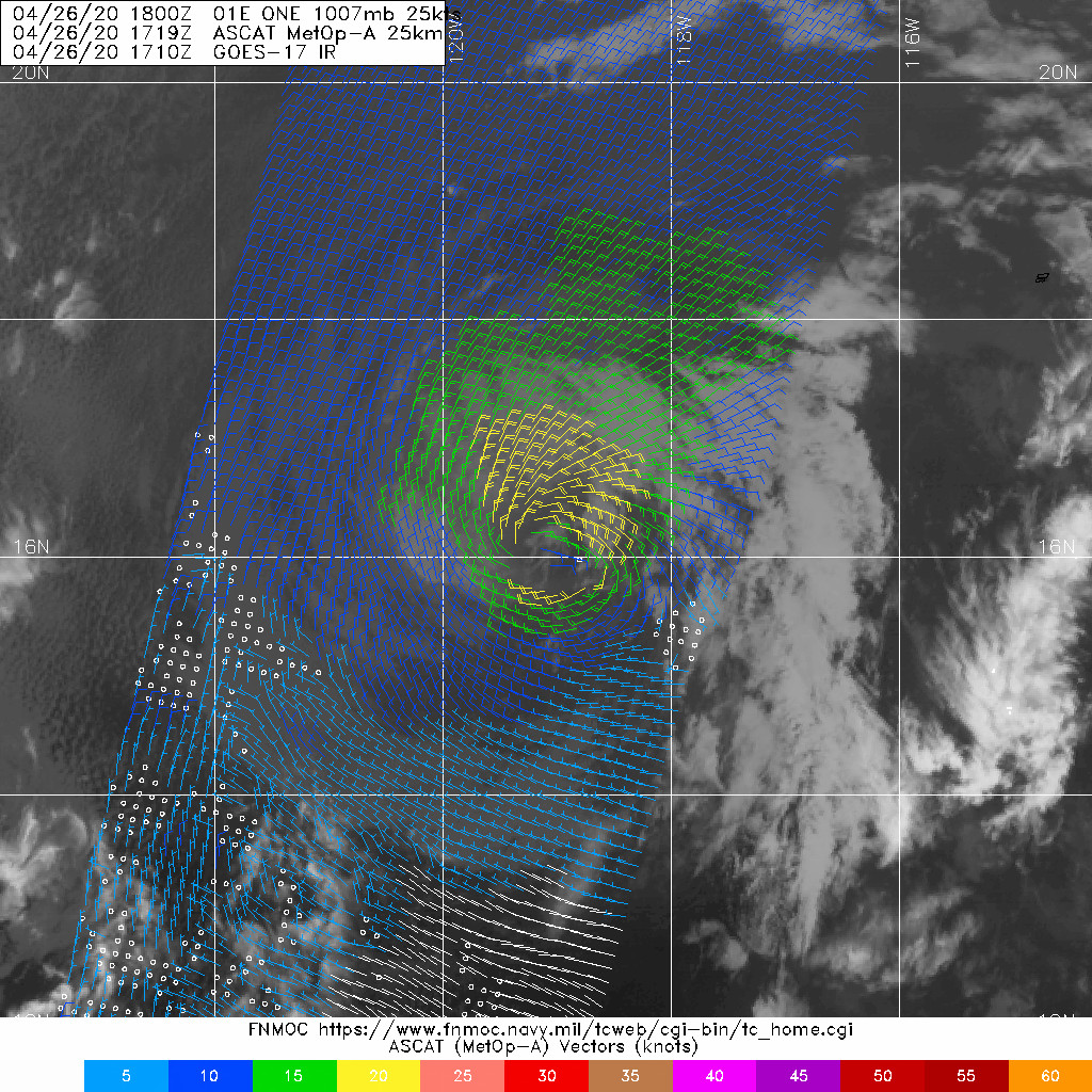
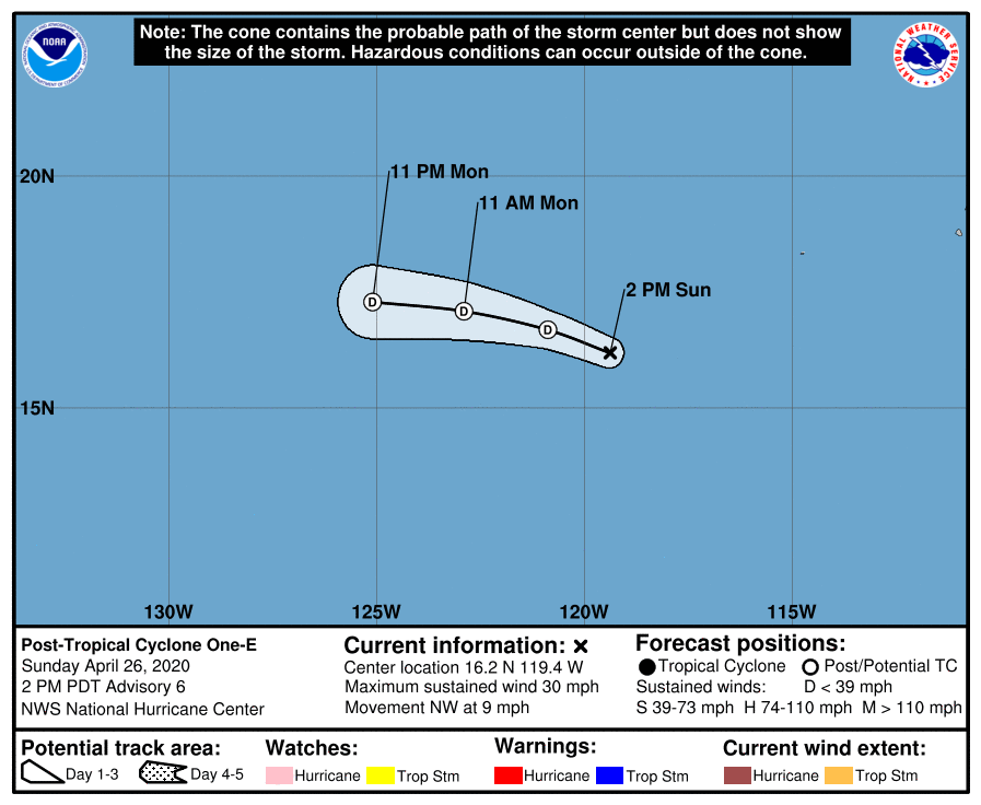
NHC26/21Z判定01E已成為後熱帶氣旋,並發出最終報
000
WTPZ41 KNHC 262035
TCDEP1

Post-Tropical Cyclone One-E Discussion Number   6
NWS National Hurricane Center Miami FL       EP012020
200 PM PDT Sun Apr 26 2020

The cyclone has lacked significant organized deep convection for at
least 10 hours, and the system is moving into increasingly more
stable air and over sub-25C deg C SSTs. Therefore, the depression
has been downgraded to a post-tropical remnant low. The initial
intensity is 25 kt is based on several 23-25 kt wind vectors located
n-e of the low-level center in a 1718 UTC ASCAT-A overpass. Although
the system may still produce some sporadic convection late tonight
during the convective maximum period, dry and stable air along with
strong westerly shear will likely prevent any appreciable convection
from persisting over the next day or so. This should cause the
remnant low to weaken and then open up into a trough in 36-48 hours.

The initial motion remains 305/08 kt. A substantial low- to
mid-level ridge to the north of the cyclone is expected to gradually
nudge the shallow low toward the west-northwest later this
afternoon, followed by a westward motion tonight, with that motion
continuing until the system dissipates Monday night. The new NHC
track forecast is essentially just an update of the previous
advisory track.

This is the last advisory issued by the National Hurricane Center on
this system.  For additional information on the remnant low, please
see High Seas Forecasts issued by the National Weather Service,
under AWIPS header NFDHSFEPI, WMO header FZPN02 KWBC, and on the web
at ocean.weather.gov/shtml/NFDHSFEPI.php .


FORECAST POSITIONS AND MAX WINDS

INIT  26/2100Z 16.2N 119.4W   25 KT  30 MPH...POST-TROPICAL
12H  27/0600Z 16.7N 120.9W   20 KT  25 MPH...POST-TROP/REMNT LOW
24H  27/1800Z 17.1N 122.9W   20 KT  25 MPH...POST-TROP/REMNT LOW
36H  28/0600Z 17.3N 125.1W   20 KT  25 MPH...POST-TROP/REMNT LOW
48H  28/1800Z...DISSIPATED

$$
Forecaster Stewart
203610_5day_cone_with_line_and_wind.png 20200427.0000.goes-17.vis.2km.01E.0NE.25kts.1007mb.16.1N.119.1W.pc.jpg
20200426.2126.gw1.89pct89h89v.01E.ONE.25kts.1007mb.16.1N.119.1W.89pc.jpg 20200426.2126.gw1.89hw.01E.ONE.25kts.1007mb.16.1N.119.1W.89pc.jpg
LATEST.jpg
回復

使用道具 舉報

快速回覆
您需要登錄後才可以回帖 登錄 | 立即加入

本版積分規則

本平台僅供學術討論之用,預報應以氣象局為準

威普網站虛擬主機贊助公司

臺灣第一個天氣類型社群平台 即時天氣資訊、精準颱風動態

線上客服
FB傳送訊息
廣告行銷
精準行銷 物超所值
官方粉專
發佈 快速回復 返回頂部 返回列表