開啟輔助訪問
 找回密碼
 立即加入

12E.Genevieve 東太今年最強颶風 自下加利福尼亞半島西岸北上

簽到天數: 53 天

[LV.5]常住居民I

天篷大元帥|2020-8-17 23:04 | 顯示全部樓層
國家颶風中心:颶風
原文:
425
WTPZ42 KNHC 171451
TCDEP2

Hurricane Genevieve Discussion Number   5
NWS National Hurricane Center Miami FL       EP122020
1000 AM CDT Mon Aug 17 2020

Data from a recent SSMIS microwave overpass reveals that an eye is
trying to form underneath the deep convection of Genevieve, but
there is some dry air near the center that may be disrupting the
formation of a solid eyewall. Despite that dry air, large bands
continue to the southwest and northwest of the center, and the deep
convection over the center is expanding in size. The latest Dvorak
satellite intensity estimates from both TAFB and SAB support raising
the initial intensity to 65 kt, making Genevieve the third hurricane
of the 2020 Eastern Pacific hurricane season.

Genevieve jogged a little northwest over the past few hours, but the
longer term motion has been west-northwest at 16 kt. The main
steering mechanism for the cyclone is a strong mid-level ridge which
extends from the southwestern United States southeastward into
Mexico. The model guidance varies slightly on the strength and
orientation of this ridge over the next few days, which could play a
role in how close Genevieve gets to the southern portion of the Baja
California Peninsula. The GFS is the farthest east, but still keeps
the center well offshore, while The UKMET is the westernmost
solution. Overall, the guidance has changed little since early this
morning, and the official forecast is very near the previous track,
which lies near the TVCX/TVCE consensus.

The small amount of dry air near the center should get worked out
of the circulation shortly, and there is high confidence that
the rapid intensification of Genevieve will continue for the next
24-36 h. The SHIPS Rapid Intensification Index (RII) shows a greater
than 95 percent chance of a 30 kt increase in strength in the next
24 h, and nearly an 80 percent chance of a 45 kt increase in
the next 36 h. The global, regional, and consensus intensity aids
all agree that rapid intensification will occur in one form or
another during this time frame as well. The official intensity
forecast is a blend of the HFIP corrected consensus and the IVCN
consensus, and is very close to the previous forecast.

Large swells generated by Genevieve are expected to begin affecting
portions of the coast of southern Mexico today and will spread
northward along the coast of Mexico to the Baja California
peninsula by Wednesday.


FORECAST POSITIONS AND MAX WINDS

INIT  17/1500Z 14.3N 103.0W   65 KT  75 MPH
12H  18/0000Z 15.4N 105.0W   85 KT 100 MPH
24H  18/1200Z 17.0N 107.3W  105 KT 120 MPH
36H  19/0000Z 18.4N 109.0W  120 KT 140 MPH
48H  19/1200Z 19.7N 110.2W  120 KT 140 MPH
60H  20/0000Z 21.0N 111.1W  110 KT 125 MPH
72H  20/1200Z 22.2N 112.4W   95 KT 110 MPH
96H  21/1200Z 24.3N 115.2W   65 KT  75 MPH
120H  22/1200Z 26.4N 118.7W   45 KT  50 MPH

$$
Forecaster Latto

機器翻譯(粗劣僅供參考):
425
WTPZ42 KNHC 171451
TCDEP2

吉內維芙颶風討論5
新創建國家颶風中心邁阿密FL EP122020
CDT 1000 AM 2020年8月17日星期一

來自最近的SSMIS微波立交橋的數據表明,
試圖在吉納維芙的對流中形成,但是
中心附近有一些乾燥的空氣,可能會干擾
形成堅固的眼牆。儘管空氣乾燥,大樂隊
繼續向中心的西南和西北方向延伸
對中心的對流正在擴大。最新的德沃夏克
TAFB和SAB支持提高的衛​​星強度估計
初始強度達到65 kt,使Genevieve成為第三次颶風
2020年東太平洋颶風季節。

吉恩維芙(Genevieve)在過去的幾個小時裡向西北慢跑了一點,但是
較長期的運動是在16 kt處西北偏西。主要的
旋風的操縱機構是堅固的中層山脊
從美國西南部向東南延伸到
墨西哥。模型指導的強度和
未來幾天該山脊的方向,可能會
Genevieve與巴哈南部的距離有多近
加利福尼亞半島。GFS是最遠的東部,但仍然保持
中心海上,而UKMET是最西端
解。總體而言,自此初期以來,指南的變化很小
早上,官方預報非常接近先前的路線,
這接近TVCX / TVCE共識。

中心附近應有少量乾燥空氣
很快就會有信心
Genevieve的快速集約化將持續到下一個
24-36小時 SHIPS快速集約化指數(RII)更高
下一輪力量增加30 kt的可能性超過95%
24小時內,增加45 kt的機率接近80%
接下來的36小時。全球,區域和共識強度幫助
所有人都同意,快速集約化將以一種形式發生,或者
在此時間範圍內也是如此。官方強度
預測是HFIP校正後的共識和IVCN的結合
共識,並且非常接近先前的預測。

吉納維芙(Genevieve)產生的大浪有望開始影響
今天墨西哥南部海岸的部分地區,將擴散
沿墨西哥海岸向北至下加利福尼亞州
半島到星期三。


預測位置和最大風

初始化17 / 1500Z 14.3N 103.0W 65 KT 75 MPH
12H 18 / 0000Z 15.4N 105.0W 85 KT 100 MPH
24H 18 / 1200Z 17.0N 107.3W 105 KT 120 MPH
36H 19 / 0000Z 18.4N 109.0W 120 KT 140 MPH
48H 19 / 1200Z 19.7N 110.2W 120 KT 140 MPH
60H 20 / 0000Z 21.0N 111.1W 110 KT 125 MPH
72H 20 / 1200Z 22.2N 112.4W 95 KT 110 MPH
96H 21 / 1200Z 24.3N 115.2W 65 KT 75 MPH
120H 22 / 1200Z 26.4N 118.7W 45 KT 50 MPH

$$
預報員拉托

預報圖

預報圖
回復

使用道具 舉報

簽到天數: 601 天

[LV.9]以壇為家II

霧峰追風者|2020-8-18 12:52 | 顯示全部樓層
NHC 底層建立,稍早強度升C2,有機會挑戰C4。
315
WTPZ42 KNHC 180233
TCDEP2

Hurricane Genevieve Discussion Number   7
NWS National Hurricane Center Miami FL       EP122020
900 PM MDT Mon Aug 17 2020

Genevieve's rapid intensification phase continues, having
strengthened 40 kt over the past 24 hours. The upper-level outflow
pattern has continued to expand, and outflow channels to the north
and south have become evident in water vapor imagery and UW-CIMSS
upper-level wind analyses. A 20-nmi-wide, cloud-filled eye has
appeared in infrared and visible satellite imagery during the past
few hours, indicating that Genevieve's wind field and vertical
structure has improved significantly since the previous advisory.
Subjective satellite intensity estimates are T5.0/90 kt from TAFB
and T4.5/77 kt from SAB, while objective estimates are T4.7/82 kt
from UW-CIMSS ADT and T5.1/92 kt from the NHC. An average of these
estimates supports an initial intensity of 85 kt.

Genevieve has remained a well-behaved hurricane and lies on the
previous advisory track, maintaining a motion of 300/15 kt. The
hurricane is expected to continue moving west-northwestward for the
next 12 hours or so while the cyclone skirts the southwestern
periphery of a broad deep-layer ridge. A slight motion shift toward
the northwest is forecast during the 24-48 hour period, bringing
Genevieve's outer wind field a little closer to Baja California Sur.
Thereafter, a motion back toward the west-northwest is forecast,
which will keep the center of the hurricane moving parallel to but
offshore the west coast of Baja California Sur. The new NHC forecast
track is essentially just an extension of the previous advisory
track, and lies down the middle of the tightly packed simple and
corrected-consensus models.

Genevieve is forecast to continue its rapid intensification phase
for the next 36 hours or so while the hurricane moves within an
extremely favorable environment characterized by low vertical wind
shear less than 5 kt, dual outflow channels, sea-surface
temperatures (SSTs) of 29-30C, and a very moist middle-troposphere.
By 48 hours, the hurricane will be moving over upper-ocean heat
content values of less than 5 units due to shallow warm ocean layer,
likely resulting in significant cold upwelling occurring. This
should initiate a gradual weakening trend, followed by rapid
weakening after 60 hours when Genevieve will be moving over sub-25
deg C water. By 120 hours, the hurricane is expected to degenerate
into a convection-free post-tropical cyclone over 21 deg C SSTs. The
NHC official intensity forecast remains near the the upper end of
the intensity guidance, and is similar to the previous advisory.

Key Messages:

1. There is an increasing risk of tropical-storm-force winds over
the southern portion of the Baja California peninsula beginning
Wednesday afternoon and continuing into Thursday as Genevieve passes
near or southwest of the southern tip of Baja California, and a
Tropical Storm Watch is in effect for a portion of this area.

2. Large swells generated by Genevieve are affecting portions of the
coast of southern Mexico and will spread northward along the coast
of Mexico to the Baja California peninsula by Wednesday.


FORECAST POSITIONS AND MAX WINDS

INIT  18/0300Z 16.5N 106.0W   85 KT 100 MPH
12H  18/1200Z 17.5N 107.5W  100 KT 115 MPH
24H  19/0000Z 18.9N 109.3W  115 KT 130 MPH
36H  19/1200Z 20.1N 110.5W  120 KT 140 MPH
48H  20/0000Z 21.2N 111.4W  115 KT 130 MPH
60H  20/1200Z 22.3N 112.5W  100 KT 115 MPH
72H  21/0000Z 23.3N 113.8W   85 KT 100 MPH
96H  22/0000Z 25.4N 117.0W   60 KT  70 MPH
120H  23/0000Z 27.9N 120.5W   40 KT  45 MPH...POST-TROPICAL

$$
Forecaster Stewart
20200818.0020.goes-17.vis.2km.12E.GENEVIEVE.75kts.985mb.15N.103.9W.pc.jpg 20200818.0107.f17.ir.olsircomp.12E.GENEVIEVE.x.jpg 20200818.0109.f17.91h.12E.GENEVIEVE.85kts.976mb.16N.105.3W.075pc.jpg
回復

使用道具 舉報

簽到天數: 1650 天

[LV.Master]伴壇終老

老農民版夜神月|2020-8-18 17:01 | 顯示全部樓層
本帖最後由 老農民版夜神月 於 2020-8-18 17:05 編輯

NHC09Z升格MH,定強100KT,並上望+24H125KT
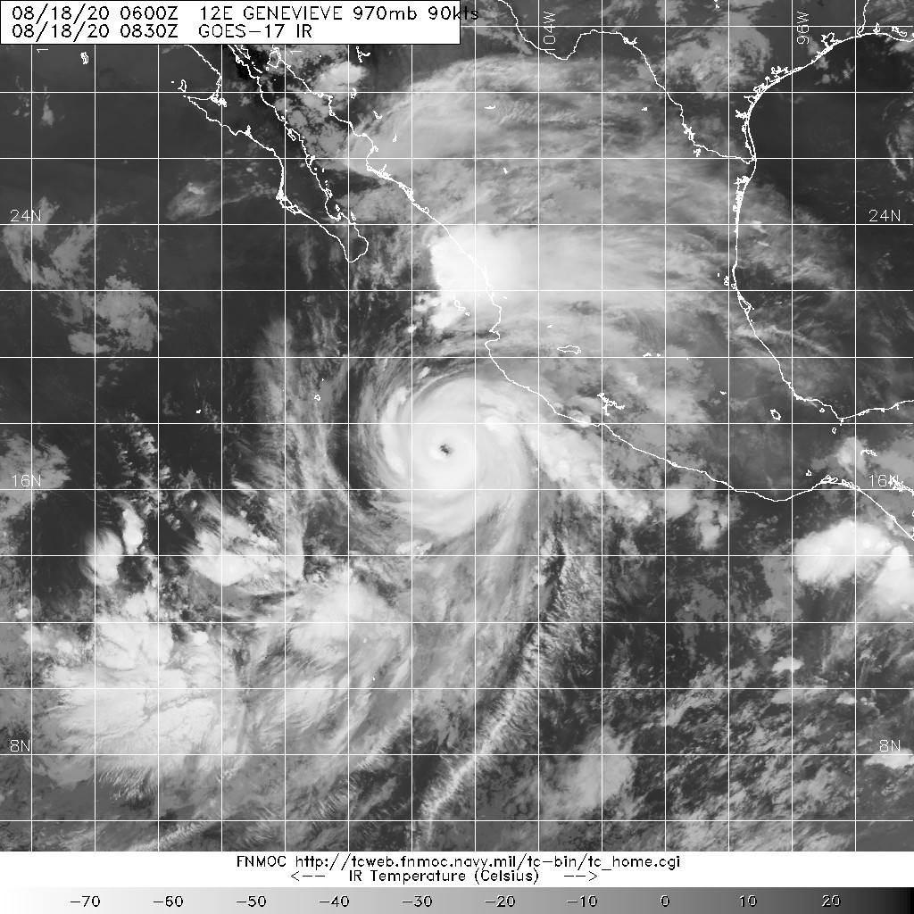
WTPZ42 KNHC 180851
TCDEP2

Hurricane Genevieve Discussion Number   8
NWS National Hurricane Center Miami FL       EP122020
300 AM MDT Tue Aug 18 2020

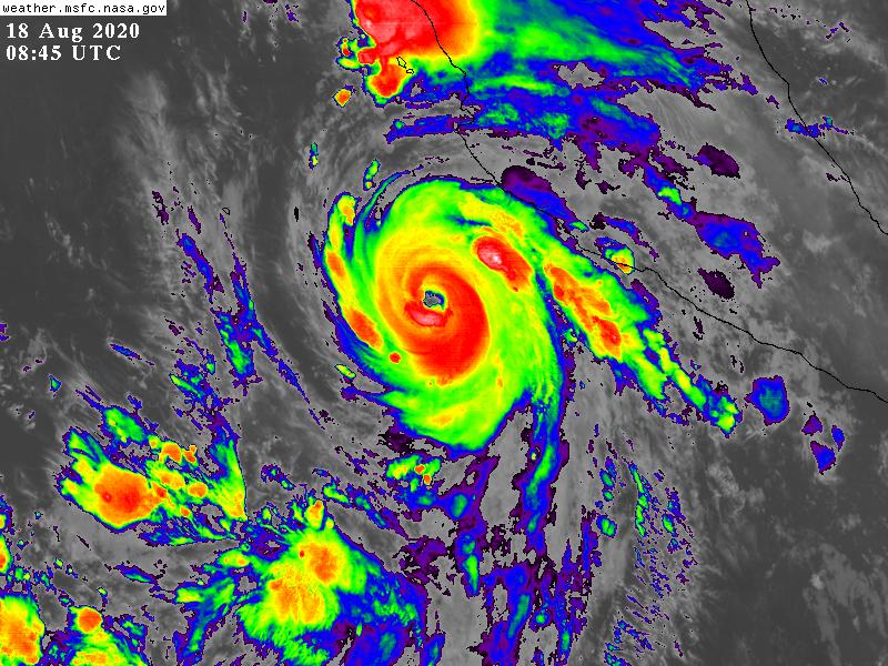
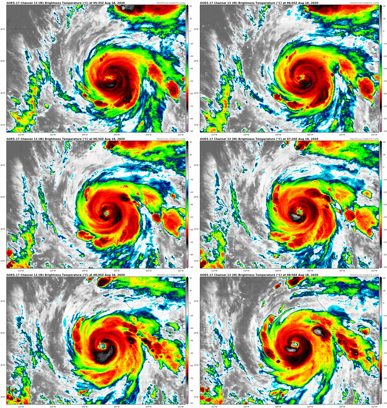
Genevieve continues to rapidly intensify this morning.  A recent
GMI microwave overpass shows a well-defined eye and eyewall
present, and the eye is becoming much better defined in conventional
infrared imagery.  Various objective and subjective satellite
intensity estimates were averaging about 90 kt at 06Z, and recent
objective raw T-numbers from the CIMSS ADT technique have increased
to between 100-115 kt.  Based on these data, the initial intensity
is raised to 100 kt, making Genevieve a major category 3 hurricane
on the Saffir-Simpson Hurricane Wind Scale.

The initial motion is now northwestward or 310/15 kt.  The
hurricane is on the southwest side of a deep-layer ridge, and the
global models forecast this feature to persist for the next several
days.  This should cause Genevieve to continue a northwestward
motion during the forecast period with some decrease in forward
speed.  On the forecast track, the center of the hurricane should
move parallel to, but offshore of, the southwestern coast of Mexico
and the Baja California peninsula.  The track model guidance
remains tightly clustered, and the new forecast track is a little
to the east of, and slightly slower than, the previous forecast.

Environmental conditions appear favorable for continued rapid
intensification during the next 24 h or so, with the only alternate
possibility being that the intensification is interrupted by an
eyewall replacement cycle.  By 36-48 h, the center will be over
decreasing sea surface temperatures and oceanic heat content, and
during that time, Genevieve should start weakening.  By the end of
the forecast period, the cyclone is forecast to be over sea surface
temperatures of 21-22C, which should cause rapid weakening.  The
new intensity forecast goes above the guidance in calling for a
peak intensity of 125 kt in 24 h, and it would not be a surprise if
Genevieve became stronger than that.  After the peak, the new
forecast shows steady to rapid weakening, and by 120 hours the
system is expected to degenerate into a convection-free
post-tropical cyclone.

The forecast track and wind radii require a Tropical Storm
Warning for the southern portion of the Baja California Peninsula
at this time.

Key Messages:

1. There is an increasing risk of tropical-storm-force winds over
the southern portion of the Baja California peninsula beginning
Wednesday afternoon and continuing into Thursday as Genevieve passes
near or southwest of the southern tip of Baja California, and a
Tropical Storm Warning is now in effect for a portion of this area.

2. Large swells generated by Genevieve are affecting portions of the
coast of southern Mexico and will spread northward along the coast
of Mexico to the Baja California peninsula by Wednesday.


FORECAST POSITIONS AND MAX WINDS

INIT  18/0900Z 17.4N 107.1W  100 KT 115 MPH
12H  18/1800Z 18.5N 108.7W  115 KT 130 MPH
24H  19/0600Z 19.7N 110.0W  125 KT 145 MPH
36H  19/1800Z 20.9N 111.0W  120 KT 140 MPH
48H  20/0600Z 21.9N 111.9W  110 KT 125 MPH
60H  20/1800Z 23.0N 113.0W   95 KT 110 MPH
72H  21/0600Z 23.9N 114.4W   80 KT  90 MPH
96H  22/0600Z 26.0N 117.5W   55 KT  65 MPH
120H  23/0600Z 28.5N 121.0W   35 KT  40 MPH...POST-TROPICAL

$$
Forecaster Beven
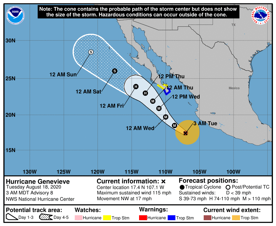
EP122020_5day_cone_no_line_and_wind.png 20200818.0830.goes-17.ir.12E.GENEVIEVE.90kts.970mb.17N.106.6W.100pc.jpg
GOES08452020231aEj5yP.jpg goes17_ir_12E_202008180535.gif
回復

使用道具 舉報

簽到天數: 53 天

[LV.5]常住居民I

天篷大元帥|2020-8-18 20:33 | 顯示全部樓層
Genevieve在三小時內強度增加15節
有機會挑戰連續兩世C5強度,上一世最高強度140節,但非五級颶風;同時已發熱帶風暴警告。
原文:
091
WTPZ32 KNHC 181141
TCPEP2

BULLETIN
Hurricane Genevieve Intermediate Advisory Number 8A
NWS National Hurricane Center Miami FL       EP122020
600 AM MDT Tue Aug 18 2020

...GENEVIEVE RAPIDLY INTENSIFIES TO A CATEGORY 4 HURRICANE...
...TROPICAL STORM CONDITIONS EXPECTED OVER PORTIONS OF THE SOUTHERN
BAJA CALIFORNIA PENINSULA WHEN GENEVIEVE PASSES TO THE WEST ON
WEDNESDAY...


SUMMARY OF 600 AM MDT...1200 UTC...INFORMATION
----------------------------------------------
LOCATION...17.7N 107.6W
ABOUT 235 MI...380 KM WSW OF MANZANILLO MEXICO
ABOUT 390 MI...630 KM SSE OF THE SOUTHERN TIP OF BAJA CALIFORNIA
MAXIMUM SUSTAINED WINDS...130 MPH...210 KM/H
PRESENT MOVEMENT...NW OR 310 DEGREES AT 16 MPH...26 KM/H
MINIMUM CENTRAL PRESSURE...950 MB...28.05 INCHES


WATCHES AND WARNINGS
--------------------
CHANGES WITH THIS ADVISORY:

None.

SUMMARY OF WATCHES AND WARNINGS IN EFFECT:

A Tropical Storm Warning is in effect for...
* Southern Baja California peninsula from Los Barriles to Todos
Santos

A Tropical Storm Watch is in effect for...
* The east coast of the Baja California peninsula from Los Barriles
to La Paz
* The west coast of the Baja California peninsula from Todos Santos
to Santa Fe

A Tropical Storm Warning means that tropical storm conditions are
expected somewhere within the warning area within 36 hours.

A Tropical Storm Watch means that tropical storm conditions are
possible within the watch area, generally within 48 hours.

For storm information specific to your area, please monitor
products issued by your national meteorological service.


DISCUSSION AND OUTLOOK
----------------------
At 600 AM MDT (1200 UTC), the eye of Hurricane Genevieve was located
near latitude 17.7 North, longitude 107.6 West. Genevieve is moving
toward the northwest near 16 mph (26 km/h), and this general motion
is expected to continue with a decrease in forward speed through
early Thursday.  On the forecast track, the center of Genevieve is
expected to move parallel to but well offshore the coast of
southwestern Mexico during the next day or so. The center of the
hurricane is forecast to move to the southwest of the southern
portion of the Baja California peninsula on Wednesday night and
Thursday.

Maximum sustained winds have increased to near 130 mph (210 km/h)
with higher gusts.  Genevieve is a category 4 hurricane on the
Saffir-Simpson Hurricane Wind Scale.  Additional rapid strengthening
is possible during the next 12 to 24 hours.  Rapid weakening is
forecast to begin by late Wednesday and should continue through the
end of the week.

Hurricane-force winds extend outward up to 30 miles (45 km) from
the center and tropical-storm-force winds extend outward up to 150
miles (240 km).

The estimated minimum central pressure is 950 mb (28.05 inches).


HAZARDS AFFECTING LAND
----------------------
WIND:  Tropical storm conditions are expected within the warning
area in the southern Baja California peninsula by Wednesday
afternoon, especially over higher terrain.  Tropical storm
conditions are possible within the watch area by Wednesday night or
Thursday morning, especially over higher terrain.

SURF:  Large swells produced by Genevieve are affecting portions of
the southern coast of Mexico and will spread northward along the
southwestern and west-central coast of Mexico to the Baja California
peninsula through Wednesday.  These swells are likely to cause
life-threatening surf and rip current conditions.  Please consult
products from your local weather office.


NEXT ADVISORY
-------------
Next complete advisory at 900 AM MDT.

$$
Forecaster Zelinsky
機器翻譯(翻譯粗劣僅供參考)
091
WTPZ32 KNHC 181141
TCPEP2

通報
颶風吉納維芙中級諮詢號碼8A
NWS美國國家颶風中心邁阿密佛羅里達州EP122020
600 AM MDT星期二2020年8月18日

... GENEVIEVE加劇-快一個類別4級颶風...
...熱帶風暴條件預計在部分南
下加利福尼亞半島WHEN GENEVIEVE傳遞到西
星期三...


作者600 AM MDT ... 1200 UTC內容...信息
-------------------- --------------------------
位置... 17.7N 107.6W
關於235 MI ... 380公里WSW的MANZANILLO墨西哥
關於390 MI。 ..630公里南下巴加加利福尼亞
最大持續風... 130 MPH ... 210 KM / H
當前運動... NW或310 MP每小時16 MPH ... 26 KM / H
最低中央壓力... 950 MB ... 28.05包括表


和警告
--------------------
更改此建議:

無。

手錶和警告的摘要:

一項熱帶風暴警告的
有效期是... *從洛斯巴里萊斯到托多斯
桑托斯的南下加利福尼亞半島有效

的熱帶風暴監視... ...
*下加利福尼亞州半島的東海岸從Los Barriles
到La Paz
*下加利福尼亞半島的西海岸,從Todos Santos
到Santa Fe

熱帶風暴警告意味著
在36小時內預計在警告區域內的某個地方會有熱帶風暴情況。

熱帶風暴監視意味著
通常在48小時內在監視區域內可能發生熱帶風暴情況。

有關特定於您所在地區的風暴信息,請監視
您的國家氣象服務部門發布的產品。


討論與展望
-------
在美國東部時間600 AM(1200 UTC),吉納維芙颶風的視線位於
北緯17.7,西經107.6。吉恩維芙(Genevieve)正在
向西北移動,速度接近16英里/小時(26 km / h),並且
預計該總體運動將繼續進行,並通過
週四早。在預報軌道上,杰納維耶夫的中心
預計將
在第二天左右與墨西哥西南海岸的海岸平行但在近海處移動。
颶風的中心預計
在周三晚和
周四移至下加利福尼亞半島南部的西南部。

陣風更高,最大持續風速增加到接近130 mph(210 km / h)
。Genevieve是
Saffir-Simpson颶風風標上的4 級颶風。
在接下來的12到24小時內,可能會進一步快速加固。
預計迅速減弱將在周三晚開始,並將持續到
本週末。

颶風將向
中心延伸最多30英里(45公里),熱帶風暴將向中心延伸最多150
英里(240公里)。

估計的最小中心壓力為950 mb(28.05英寸)。


影響土地的危險
----------------------
風:預計在
星期三
下午之前,南下加利福尼亞半島的警告區域內將出現熱帶風暴,特別是在較高的地形上。
監視區域可能在星期三晚上或
星期四早晨之前出現熱帶風暴,尤其是在較高的地形上。

SURF:Genevieve產生的大浪影響了部分
墨西哥南部海岸,並將
在周三沿墨西哥
西南部和中西部海岸向北擴展至下加利福尼亞半島。這些膨脹很可能導致
危及生命的海浪和翻滾電流狀況。請諮詢
當地氣象局的產品。


一個建議
------------- 下一個完整的諮詢時間為MDT 900 AM。

$$
預報員Zelinsky


goes17_ir_12E_202008180850.gif
回復

使用道具 舉報

簽到天數: 3279 天

[LV.Master]伴壇終老

t02436|2020-8-18 23:03 | 顯示全部樓層
15Z評價115節,上望130節。
000
WTPZ42 KNHC 181458
TCDEP2

Hurricane Genevieve Discussion Number   9
NWS National Hurricane Center Miami FL       EP122020
900 AM MDT Tue Aug 18 2020

Since the issuance of the last advisory, Genevieve has continued to
rapidly intensify. The major hurricane has a very well-defined and
clear eye and microwave imagery as recent as 12Z did not show any
indication of a secondary eyewall. Objective intensity estimates
from the UW-CIMSS SATCON were as high as 124 kt earlier this
morning, but subjective Dvorak estimates at 12Z were a little lower
due to the formation of a small break in the cold cloud tops
surrounding Genevieve's eye. Even then, a blend of all available
intensity estimates still supports an intensity of 115 kt for this
advisory.

Additional rapid strengthening is possible for at least the next
12 h given the current structure of the hurricane and the extremely
favorable environment it is moving through. The NHC forecast is well
above the guidance for the next 24 h out of respect for that
possibility. It is worth noting that eyewall replacement cycles are
generally poorly forecast and the onset of one could bring an
abrupt halt to Genevieve's intensification. By the time Genevieve
nears the Baja California peninsula on late Wednesday, rapid
weakening is expected as the system moves over cooler waters and
encounters an increase in southwesterly shear associated with an
upper-level trough to the northwest. Upwelling from the hurricane's
own wind field and decreasing forward speed could also bring about
weakening. By the end of the weak Genevieve will likely weaken to a
tropical storm and then become a remnant low.

The hurricane is moving slightly slower toward the northwest and a
further decrease in forward speed is anticipated for the next day
or two. There was no substantial change made to the NHC track
forecast, and Genevieve is still predicted to be steered just west
of the Baja California peninsula by a deep-layer ridge centered over
the southwestern U.S. The track guidance remains tightly clustered,
so confidence in the forecast remains fairly high.

Key Messages:

1. The center of Genevieve is forecast to move just west of the Baja
California peninsula, but it is still expected to cause tropical
storm conditions across portions of southern Baja California Sur.
These conditions are expected to begin Wednesday afternoon and
could spread northwestward through Thursday.

2. Large swells generated by Genevieve are affecting portions of the
coast of southern Mexico and will spread northward along the coast
of Mexico to the Baja California peninsula by Wednesday.


FORECAST POSITIONS AND MAX WINDS

INIT  18/1500Z 18.0N 108.0W  115 KT 130 MPH
12H  19/0000Z 19.0N 109.3W  130 KT 150 MPH
24H  19/1200Z 20.2N 110.4W  130 KT 150 MPH
36H  20/0000Z 21.3N 111.3W  120 KT 140 MPH
48H  20/1200Z 22.2N 112.3W  105 KT 120 MPH
60H  21/0000Z 23.2N 113.5W   90 KT 105 MPH
72H  21/1200Z 24.1N 115.0W   75 KT  85 MPH
96H  22/1200Z 26.3N 118.1W   50 KT  60 MPH
120H  23/1200Z 28.7N 121.4W   35 KT  40 MPH...POST-TROPICAL

$$
Forecaster Zelinsky

145951_5day_cone_with_line.png
回復

使用道具 舉報

簽到天數: 601 天

[LV.9]以壇為家II

霧峰追風者|2020-8-19 10:51 | 顯示全部樓層
稍早強度減弱為C3,不再看好增強,將逐漸減弱。
000
WTPZ42 KNHC 190234
TCDEP2

Hurricane Genevieve Discussion Number  11
NWS National Hurricane Center Miami FL       EP122020
900 PM MDT Tue Aug 18 2020

While Genevieve continues to have a distinct eye on satellite
images, the inner-core convection has weakened during the past
several hours, although there is little evidence of any eyewall
replacement cycle starting. The majority of the satellite estimates
range from 100 to 110 kt, and a blend of these values gives an
initial wind speed of 105 kt.

My strong suspicion is that the hurricane has weakened today due to
it encountering cooler SSTs from the wake of Hurricane Elida (from
last week), and these waters will likely help limit any near-term
chance of strengthening.  While Genevieve should move north of the
wake tomorrow, its slow movement and fairly large size could help
to maintain upwelling and cooler waters near the core. In a couple
of days, quickly falling SSTs should cause rapid weakening, and
Genevieve is forecast to be a non-convective low in 4 days over
waters near 23C. The new forecast is lower than the previous one,
but it is still above the model consensus at most times before 48
hours.

The hurricane has turned to the right tonight, with the latest
initial motion estimated to be 325/9 kt.  A slightly slower
northwestward to north-northwestward motion is expected during the
next day or so due to steering from a distant ridge over central
Mexico, taking the core of the hurricane near but just west of the
southern Baja California peninsula during that time.  Similar to the
previous cycle, the models have shifted closer to the Baja
California Sur coast but still about 60 n mi offshore, and the NHC
forecast is adjusted in that direction. Thereafter, a mid-level
ridge over the southwestern United States should cause Genevieve to
turn more toward the west-northwest or northwest, away from the Baja
coast. A small eastward trend is noted at long range as well, and
the official forecast follows that lead.

Key Messages:

1. The center of Genevieve is forecast to move just west of the Baja
California peninsula, but it is still expected to cause tropical
storm conditions across portions of southern Baja California Sur.
These conditions are expected to begin Wednesday afternoon and
could spread northwestward through Thursday.

2. Large swells generated by Genevieve are affecting portions of the
coast of southern Mexico and will spread northward along the coast
of Mexico to the Baja California peninsula through Thursday.


FORECAST POSITIONS AND MAX WINDS

INIT  19/0300Z 19.5N 109.0W  105 KT 120 MPH
12H  19/1200Z 20.5N 109.7W  105 KT 120 MPH
24H  20/0000Z 21.5N 110.4W  100 KT 115 MPH
36H  20/1200Z 22.4N 111.3W   90 KT 105 MPH
48H  21/0000Z 23.1N 112.3W   75 KT  85 MPH
60H  21/1200Z 24.0N 113.6W   65 KT  75 MPH
72H  22/0000Z 25.1N 115.2W   55 KT  65 MPH
96H  23/0000Z 27.5N 118.7W   40 KT  45 MPH...POST-TROPICAL
120H  24/0000Z 29.5N 121.5W   25 KT  30 MPH...POST-TROP/REMNT LOW

$$

Forecaster Blake
20200819.0150.goes-17.ir.12E.GENEVIEVE.110kts.953mb.19.1N.108.8W.100pc.jpg
回復

使用道具 舉報

簽到天數: 53 天

[LV.5]常住居民I

天篷大元帥|2020-8-19 23:06 | 顯示全部樓層
墨西哥政府對下加利福尼亞半島發出颶風警告
原文:
991
WTPZ32 KNHC 191457
TCPEP2

BULLETIN
Hurricane Genevieve Advisory Number  13
NWS National Hurricane Center Miami FL       EP122020
900 AM MDT Wed Aug 19 2020

...HURRICANE WARNING ISSUED FOR SOUTHERN PORTIONS OF THE BAJA
CALIFORNIA PENINSULA...


SUMMARY OF 900 AM MDT...1500 UTC...INFORMATION
----------------------------------------------
LOCATION...20.9N 109.7W
ABOUT 140 MI...225 KM S OF THE SOUTHERN TIP OF BAJA CALIFORNIA
MAXIMUM SUSTAINED WINDS...115 MPH...185 KM/H
PRESENT MOVEMENT...NNW OR 335 DEGREES AT 9 MPH...15 KM/H
MINIMUM CENTRAL PRESSURE...959 MB...28.32 INCHES


WATCHES AND WARNINGS
--------------------
CHANGES WITH THIS ADVISORY:

The government of Mexico has issued a Hurricane Warning for the
southern tip of the Baja California peninsula from Los Barriles to
Todos Santos.


The government of Mexico has extended the Tropical Storm Warning
northward along the west coast of the Baja California peninsula to
Cabo San Lazaro.

SUMMARY OF WATCHES AND WARNINGS IN EFFECT:

A Hurricane Warning is in effect for...
* Southern Baja California peninsula from Los Barriles to Todos
Santos

A Tropical Storm Warning is in effect for...
* West coast of the Baja California peninsula from north of
Todos Santos to Cabo San Lazaro

A Tropical Storm Watch is in effect for...
* The east coast of the Baja California peninsula from Los Barriles
to La Paz

A Hurricane Warning means that hurricane conditions are expected
somewhere within the warning area, in this case within the next 24
hours. Preparations to protect life and property should be rushed to
completion.

A Tropical Storm Warning means that tropical storm conditions are
expected somewhere within the warning area within 36 hours.

A Tropical Storm Watch means that tropical storm conditions are
possible within the watch area, generally within 48 hours.

For storm information specific to your area, please monitor
products issued by your national meteorological service.


DISCUSSION AND OUTLOOK
----------------------
At 900 AM MDT (1500 UTC), the center of Hurricane Genevieve was
located near latitude 20.9 North, longitude 109.7 West. Genevieve is
moving toward the north-northwest near 9 mph (15 km/h).  A turn
toward the northwest is expected this afternoon or tonight, with
this motion continuing through Friday night.  On the forecast
track, the center of Genevieve is expected to move near but just
southwest of the southern portion of the Baja California peninsula
tonight and Thursday, and move away from the peninsula on Friday.

Maximum sustained winds are near 115 mph (185 km/h) with higher
gusts.  Genevieve is a category 3 hurricane on the Saffir-Simpson
Hurricane Wind Scale.  Gradual weakening is forecast over the next
couple of days, but Genevieve is expected to remain a strong
hurricane while it passes west of the southern Baja California
peninsula.

Hurricane-force winds extend outward up to 35 miles (55 km) from the
center and tropical-storm-force winds extend outward up to 140 miles
(220 km).

The estimated minimum central pressure is 959 mb (28.32 inches).


HAZARDS AFFECTING LAND
----------------------
WIND:  Hurricane conditions are expected within the hurricane
warning area tonight and Thursday.  Tropical storm conditions are
expected within the warning area in the southern Baja California
peninsula by this afternoon, especially over higher terrain.  
Tropical storm conditions are possible within the watch area by
tonight or Thursday morning, especially over higher terrain.

RAINFALL:  Genevieve is expected to produce rainfall amounts of 3 to
6 inches with isolated totals of 10 inches across portions of far
southern Baja California Sur. This rainfall may lead to
life-threatening flash flooding and mudslides.

SURF:  Large swells produced by Genevieve are affecting portions of
the southern coast of Mexico and will spread northward along the
southwestern and west-central coast of Mexico to the Baja California
peninsula through Thursday.  These swells are likely to cause
life-threatening surf and rip current conditions.  Please consult
products from your local weather office.


NEXT ADVISORY
-------------
Next intermediate advisory at 1200 PM MDT.
Next complete advisory at 300 PM MDT.

$$
Forecaster Brown
機器翻譯(翻譯粗劣僅供參考)
991

WTPZ32 KNHC 191457
TCPEP2

通報
颶風吉納維芙諮詢號碼13
NWS美國國家颶風中心邁阿密佛羅里達州EP122020
900 AM MDT星期三2020年8月19日

...颶風警報發出了巴哈南部的部分
加利福尼亞半島
...


900 AM MDT摘要... 1500 UTC ...信息
-------------------------------------------- -
位置... 20.9N 109.7W約
140 米...南加州巴雅火山口225公里
最大持續風... 115英里/小時... 185千米/小時
當前移動... NNW或335度每小時9 MPH ... 15 KM / H
最低中央壓力... 959 MB ... 28.32英寸表


和警告
--------------------
對此建議的更改


墨西哥政府已發布颶風預警,警告從洛斯巴里萊斯到
托多斯·桑托斯的下加利福尼亞半島的南端


墨西哥政府已將熱帶風暴警告
沿下加利福尼亞半島的西海岸向北延伸至
卡波聖拉薩羅。

觀看次數和警告的摘要:

颶風警告正針對...
*從Los Barriles到Todos
Santos的南下加利福尼亞半島

熱帶風暴警告正在針對...
*北下加利福尼亞半島的西海岸的
托多斯桑托斯擦玻璃聖拉薩羅

熱帶風暴手錶是在效果...
*從Los Barriles
到La Paz 的Baja California半島東海岸

颶風警告意味著
在警告區域內可能會發生颶風,在本例中為未來24
小時。保護生命和財產的準備工作應盡快
完成。

熱帶風暴警告意味著
在36小時內預計在警告區域內的某個地方會有熱帶風暴情況。

熱帶風暴監視意味著
通常在48小時內在監視區域內可能發生熱帶風暴情況。

有關特定於您所在地區的風暴信息,請監視
您的國家氣象服務部門發布的產品。


討論與展望
----------------------
在MDT 900 AM(1500 UTC),Genevieve颶風的中心
位於北緯20.9,西經109.7。吉納維芙(Genevieve)
正在以9英里/小時(15 km / h)的速度向西北方向移動。
預計今天下午或今晚將轉向西北方向,
該議案將持續到週五晚上。在預報
軌道上,預計
今晚和星期四,吉納維芙的中心將移至
下加利福尼亞半島南部的西南部分,但僅在西南部分,而周五將移出該半島。
陣風

較高,最大持續風速接近115 mph(185 km / h)。Genevieve是Saffir-Simpson上的3級颶風
颶風規模。預計未來
幾天會逐漸減弱,但是吉內維夫(Genevieve)
穿過南下加利福尼亞
半島西部時,預計仍將保持強颶風。

颶風將向
中心延伸35英里(55公里),熱帶風暴將向中心延伸140英里
(220公里)。

估計的最小中心壓力為959 mb(28.32英寸)。


影響土地的危害
-----------
風:預計
今晚和星期四的颶風警告區內的颶風狀況。
在下加利福尼亞州南部的警告區內,預計會有熱帶風暴條件
半島到今天下午,尤其是在較高的地形上。  
今晚或星期四早晨,
在監視區內可能會出現熱帶風暴,特別是在較高的地形上。

降雨:吉納維芙預計將

南下加利福尼亞州蘇爾州的部分地區產生3至6英寸的降雨,孤立的總降雨量為10英寸。這種降雨可能導致
威脅生命的山洪和泥石流。

表面:吉恩維芙(Genevieve)產生的大浪影響
墨西哥南部海岸的部分地區,並將
在周四沿墨西哥
西南部和中西部沿海向北擴散至下加利福尼亞半島。這些膨脹可能會導致
危及生命的衝浪和翻滾潮流。請諮詢
當地氣象局的產品。


一個建議
------------- 下一個中級建議時間MDT 1200 PM。
MDT的下一個完整諮詢時間為300 PM。

$$
預報員布朗


颶風警告.png
回復

使用道具 舉報

簽到天數: 53 天

[LV.5]常住居民I

天篷大元帥|2020-8-20 07:21 | 顯示全部樓層
本帖最後由 天篷大元帥 於 2020-8-20 07:23 編輯

氣象單位進行的飛機時測,發現過去一段時間的強度遠遠高估,實測過後強度直接調降到80節。
原文(節錄):
Hurricane Genevieve Discussion Number  14
NWS National Hurricane Center Miami FL       EP122020
300 PM MDT Wed Aug 19 2020

Genevieve's satellite presentation has continued to degrade this
afternoon with the eye becoming less distinct in visible imagery and
a warming of the cloud tops in the surrounding ring of convection.  
Objective and subjective Dvorak T-numbers have continued to fall,
and the reduction in wind speed has been confirmed by recent data
from an Air Force Reserve reconnaissance aircraft that has provided
a couple of center fixes during its mission this afternoon.  
Somewhat surprisingly, the plane only reported peak flight-level
winds of 82 kt and SFMR winds of 69 kt
. The latest minimum pressure
reported by the aircraft was 974 mb.  Since the aircraft only flew a
single alpha pattern, it is possible that the strongest winds were
not captured.  Therefore the initial intensity has been
conservatively adjusted to 80 kt.  

機器翻譯(節錄)(翻譯粗劣僅供參考):
颶風金娜薇討論編號14
NWS國家颶風中心邁阿密佛羅里達州EP122020
300 PM MDT星期三2020年8月19日下午,吉恩維芙

的衛星圖像一直在變質
,因為在可見圖像中視線變得不那麼清晰,
雲頂變暖在對流環附近。  
客觀和主觀的德沃夏克T數一直在下降,
風速的下降已被
空軍預備隊偵察機的最新數據所證實,該機
在今天下午的任務中提供了兩次中心定位。  
出乎意料的是,飛機僅報告
了82 kt的峰值飛行水平風和69 kt的SFMR風

飛機報告的最新最低壓力是974 mb。由於飛機隻飛過一個
單一的阿爾法模式,有可能
沒有捕獲到最強的風。因此,初始強度已
保守地調整為80 kt。  

飛機實測

飛機實測
回復

使用道具 舉報

快速回覆
您需要登錄後才可以回帖 登錄 | 立即加入

本版積分規則

本平台僅供學術討論之用,預報應以氣象局為準

威普網站虛擬主機贊助公司

臺灣第一個天氣類型社群平台 即時天氣資訊、精準颱風動態

線上客服
FB傳送訊息
廣告行銷
精準行銷 物超所值
官方粉專
發佈 快速回復 返回頂部 返回列表