簽到天數: 1650 天 [LV.Master]伴壇終老
|
 老農民版夜神月|2020-10-28 15:19
|
顯示全部樓層
已通過猶加敦半島,即將撲向路易斯安那州
000
WTNT43 KNHC 280255
TCDAT3
Tropical Storm Zeta Discussion Number 14
NWS National Hurricane Center Miami FL AL282020
1000 PM CDT Tue Oct 27 2020
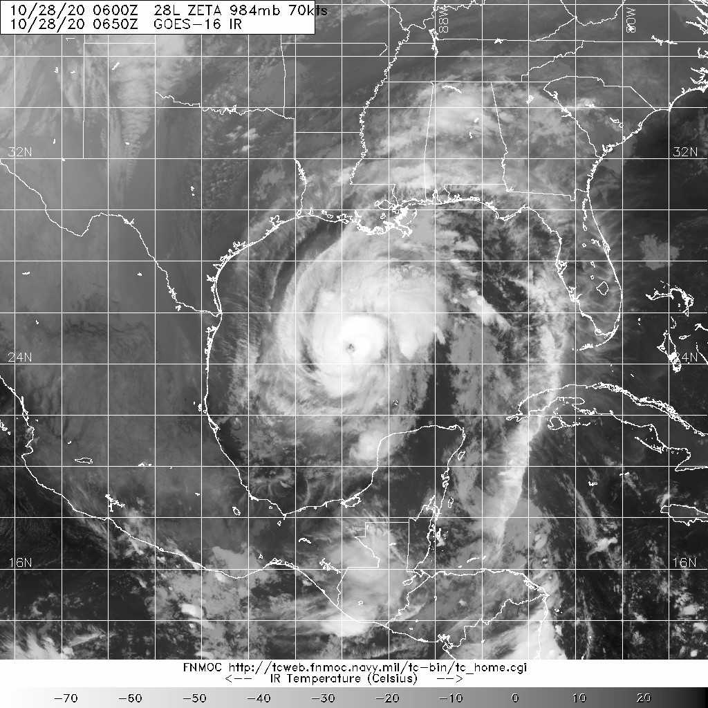
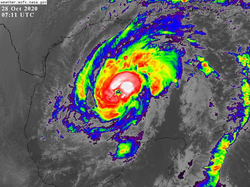
Satellite images show that Zeta is becoming better organized tonight
with a ragged eye feature now present, plenty of deep convection and
a more symmetric appearance. The Air Force Reserve Hurricane Hunter
aircraft has found increasing winds on this flight, recently
recording peak flight-level winds of 65 kt and a minimum pressure of
around 990 mb. The initial wind speed is raised to 60 kt on the
basis of the wind data.
The improving cloud pattern of Zeta is usually one that favors
intensification in the short term. In addition, microwave data from
a couple hours ago indicated that a 37 GHz low-level ring was
present, which also can be a harbinger of strengthening, and
sometimes that strengthening is on the rapid side. Since the storm
remains over warm water with fairly light shear, the NHC forecast
still anticipates Zeta regaining hurricane intensity within the next
6 hours and making a second landfall as a hurricane. The new NHC
forecast is a little higher than the previous one, remaining on the
high side of the guidance. After landfall, Zeta is likely to become
an extratropical cyclone while it approaches the eastern United
States in a couple of days, and become absorbed by the same frontal
system.
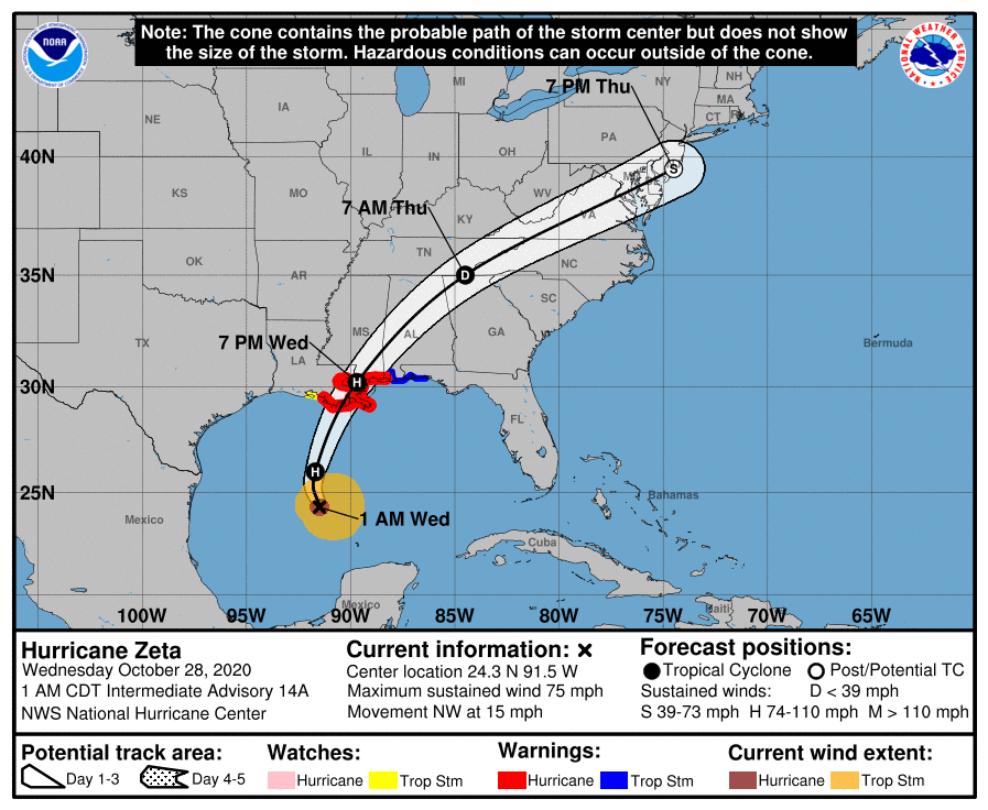
Zeta is moving northwestward a little faster tonight (325/13 kt).
The storm is expected to turn northward and move along the western
side of a mid-level anticyclone centered east of Florida through
Wednesday morning. A deep cold low (responsible for the southern
Plains ice storm) approaching from the west will cause Zeta to
sharply accelerate north-northeastward and move inland along the
southeastern Louisiana coast Wednesday afternoon. The cyclone
should continue to accelerate ahead of the trough and move over the
southeastern and eastern U.S. through Thursday. Similar to the
last forecast, the official track forecast was moved slightly
westward during the first 24 hours, not too dissimilar from a
consensus of the latest GFS, UKMET and ECMWF forecasts.
Given Zeta's acceleration near landfall, strong winds are likely to
spread well inland along the northern Gulf coast Wednesday night.
KEY MESSAGES:
1. A life-threatening storm surge is expected along portions of the
northern Gulf Coast by late Wednesday, with the highest inundation
occurring somewhere between the Mouth of the Pearl River and Dauphin
Island, Alabama. Residents in the Storm Surge Warning area should
follow any advice given by local officials.
2. Hurricane conditions are expected Wednesday afternoon within
portions of the Hurricane Warning area between Morgan City,
Louisiana, and the Mississippi/Alabama border. Damaging winds,
especially in gusts, will spread well inland across portions of
southeast Mississippi and southern Alabama Wednesday night due to
Zeta's fast forward speed.
3. Localized heavy rainfall from Zeta will continue tonight in
portions of the Yucatan Peninsula of Mexico and western Cuba where
additional flash flooding is possible in urban areas. Between
tonight and Thursday, heavy rainfall is expected from portions of
the central U.S. Gulf Coast into the Ohio Valley and Mid-Atlantic
States near and in advance of Zeta. This rainfall will lead to
flash, urban, small stream, and minor river flooding.
FORECAST POSITIONS AND MAX WINDS
INIT 28/0300Z 23.8N 91.2W 60 KT 70 MPH
12H 28/1200Z 26.0N 91.7W 75 KT 85 MPH
24H 29/0000Z 30.2N 89.7W 65 KT 75 MPH...INLAND
36H 29/1200Z 35.0N 84.5W 30 KT 35 MPH...INLAND
48H 30/0000Z 39.5N 74.5W 40 KT 45 MPH...POST-TROP/EXTRATROP
60H 30/1200Z...DISSIPATED
$$
Forecaster Blake 


|
|