開啟輔助訪問
 找回密碼
 立即加入

26S.Seroja 曾增強至澳式C3 登陸澳洲

簽到天數: 483 天

[LV.9]以壇為家II

dom|2021-4-9 21:02 | 顯示全部樓層
BoM升格澳式C2
Details of Tropical Cyclone Seroja at 8:00 pm AWST:
Intensity: Category 2, sustained winds near the centre of 95 kilometres per hour with wind gusts to 130 kilometres per hour.

Location: within 45 kilometres of 20.2 degrees South 108.8 degrees East, estimated to be 610 kilometres west northwest of Coral Bay and 720 kilometres northwest of Carnarvon.

Movement: southwest at 16 kilometres per hour.

Tropical Cyclone Seroja has intensified to a category 2 system as it tracks to the southwest over open waters well to the west of the NW Cape. Seroja will continue to intensify on Saturday as it begins to move south.

Weather conditions will change rapidly near the west coast on Sunday as Seroja is forecast to accelerate to the southeast making landfall late Sunday or early Monday between Carnarvon and Jurien Bay. The cyclone should gradually weaken as it moves inland on Monday but still likely to be causing gusty winds east and north of the track.
IDW60280.png
回復

使用道具 舉報

簽到天數: 1650 天

[LV.Master]伴壇終老

老農民版夜神月|2021-4-10 04:22 | 顯示全部樓層
本帖最後由 老農民版夜神月 於 2021-4-10 04:23 編輯

JTWC18Z定強TS上限60節
目前看來相較強度預報的激進些的JTWC,BoM在26S的強度掌握方面反而好了一些
26S SEROJA 210409 1800 20.3S 108.5E SHEM 60 982
TPXS11 PGTW 091812
A. TROPICAL CYCLONE 26S (SEROJA)
B. 09/1740Z
C. 20.68S
D. 108.21E
E. FIVE/HMWRI8
F. T3.5/3.5/D1.0/24HRS STT: S0.0/03HRS
G. IR/EIR
H. REMARKS: 38A/PBO SBC/ANMTN. .80 WRAP ON LOG10 SPIRAL YIELDS
A 3.5 DT. MET AND PT YIELD A 3.5. DBO DT.
I. ADDITIONAL POSITIONS: NONE
BERMEA
TXXS21 KNES 091814
TCSSIO
A. 26S (SEROJA)
B. 09/1730Z
C. 20.8S
D. 108.0E
E. ONE/HIMAWARI-8
F. T4.0/4.0
G. IR/EIR/SWIR
H. REMARKS...THIS INTENSITY ESTIMATE WAS DERIVED USING 4 KM IR DATA. THE
LLCC WAS EMBEDDED IN DARK GREY WHICH YIELDS A DT OF 4.0. THE MET EQUALS
A 4.5 DUE TO A DEVELOPING TREND OVER THE PAST 24 HOURS. THE PT REMAINS
AT 4.0. FT IS BASED ON PT DUE TO UNCERTAINTY IN THE EXACT LLCC POSITION
AND AN ADJUSTMENT TO THE MET WAS MADE TO OBTAIN THE PT.
I. ADDL POSITIONS
NIL
...COVERDALE

26S_gefs_latest (4).png IDW60280 (22).png
20210409.1745.gw1.89pct89h89v.26S.SEROJA.60kts.981mb.20.3S.108.5E.71pc.jpg 20210409.1745.gw1.89hbt.26S.SEROJA.60kts.981mb.20.3S.108.5E.71pc.jpg
IDW27600
TROPICAL CYCLONE TECHNICAL BULLETIN: AUSTRALIA - WESTERN REGION
Issued by AUSTRALIAN BUREAU OF METEOROLOGY TROPICAL CYCLONE WARNING CENTRE
at: 1940 UTC 09/04/2021
Name: Tropical Cyclone Seroja
Identifier: 22U
Data At: 1800 UTC
Latitude: 20.5S
Longitude: 108.4E
Location Accuracy: within 25 nm [45 km]
Movement Towards: southwest [233 deg]
Speed of Movement: 6 knots [11 km/h]
Maximum 10-Minute Wind: 50 knots [95 km/h]
Maximum 3-Second Wind Gust: 70 knots [130 km/h]
Central Pressure: 982 hPa
Radius of 34-knot winds NE quadrant: 80 nm [150 km]
Radius of 34-knot winds SE quadrant: 80 nm [150 km]
Radius of 34-knot winds SW quadrant: 80 nm [150 km]
Radius of 34-knot winds NW quadrant: 80 nm [150 km]
Radius of 48-knot winds NE quadrant: 30 nm [55 km]
Radius of 48-knot winds SE quadrant: 30 nm [55 km]
Radius of 48-knot winds SW quadrant: 30 nm [55 km]
Radius of 48-knot winds NW quadrant: 30 nm [55 km]
Radius of 64-knot winds:
Radius of Maximum Winds: 20 nm [35 km]
Dvorak Intensity Code: T3.5/3.5/D1.0/24HRS SST: D1.0/06HRS
Pressure of outermost isobar: 1002 hPa
Radius of outermost closed isobar: 120 nm [220 km]
FORECAST DATA
Date/Time    : Location    : Loc. Accuracy: Max Wind   : Central Pressure
[UTC]        : degrees     :      nm  [km]: knots[km/h]: hPa
+06:  10/0000: 20.9S 108.2E:     040 [080]:  055  [100]:  977
+12:  10/0600: 21.3S 108.2E:     055 [100]:  060  [110]:  975
+18:  10/1200: 21.9S 108.6E:     060 [115]:  065  [120]:  973
+24:  10/1800: 22.9S 109.3E:     065 [120]:  065  [120]:  973
+36:  11/0600: 25.8S 111.6E:     080 [145]:  060  [110]:  978
+48:  11/1800: 29.4S 115.9E:     115 [215]:  045  [085]:  989
+60:  12/0600: 33.3S 122.4E:     185 [340]:  030  [055]:  998
+72:  12/1800:             :              :            :     
+96:  13/1800:             :              :            :     
+120: 14/1800:             :              :            :     
REMARKS:
Seroja continues to show convection wrapping around the centre, though deep
convection is confined to the northern quadrants and has shown some warming
since 1600UTC. There is good confidence in the position of the system with a
recent microwave pass.

Dvorak analysis: FT/CI=3.5 based on DT=3.5 from curved band pattern [around 0.8
wrap], consistent with PAT. Final ADT T numbers are 3.5 [NESDIS & CIMSS].
SATCON shows intensity at 53 knots [1-min mean] at 1416 UTC. Intensity remains
at 50 knots.

The system currently lies in low 10 knot NE'ly shear [CIMSS 1800UTC], with a
moist low to mid-level environment and warm sea surface temperatures [28-29 deg]
and Intensification should continue during Saturday as it remains in a similar
one.

A poleward outflow channel is becoming evident on satellite imagery and should
continue during today as an upper trough approaches to the west of the system.
Thus there is the potential for Seroja to reach category 3 intensity in 18 to 24
hours . The intensification process of Seroja may be complicated or enhanced by
the close proximity of TC Odette on Saturday. It is expected to weaken somewhat
before reaching the coast due to the high shear environment south of 25S.

Tropical cyclone Seroja and slowed down in its southwest track and should start
to turn southward later this morning. Later Saturday it will turn to the
southeast and accelerate on Sunday due to an approaching mid-latitude trough
from the west before making landfall during late Sunday or early Monday between
Carnarvon and Jurien Bay, an area not accustomed to tropical cyclones making
impacts more significant.

Copyright Commonwealth of Australia
==
The next bulletin for this system will be issued by: 10/0130 UTC.

Time (AWST)Intensity CategoryLatitude
(decimal deg.)
Longitude
(decimal deg.)
Estimated Position
Accuracy (km)
0hr2 am April 10220.5S108.4E45
+6hr8 am April 10220.9S108.2E80
+12hr2 pm April 10221.3S108.2E100
+18hr8 pm April 10321.9S108.6E115
+24hr2 am April 11322.9S109.3E120
+36hr2 pm April 11225.8S111.6E145
+48hr2 am April 12129.4S115.9E215
+60hr2 pm April 12tropical low33.3S122.4E340
+72hr2 am April 13tropical lowXXXXXXXXX

回復

使用道具 舉報

簽到天數: 483 天

[LV.9]以壇為家II

dom|2021-4-10 22:53 | 顯示全部樓層
JTWC15Z把預測巔峰強度下調至65節, 將於+24H登陸澳洲
WTXS31 PGTW 101500
MSGID/GENADMIN/JOINT TYPHOON WRNCEN PEARL HARBOR HI//
SUBJ/TROPICAL CYCLONE 26S (SEROJA) WARNING NR 025//
RMKS/
1. TROPICAL CYCLONE 26S (SEROJA) WARNING NR 025   
   02 ACTIVE TROPICAL CYCLONES IN SOUTHIO
   MAX SUSTAINED WINDS BASED ON ONE-MINUTE AVERAGE
   WIND RADII VALID OVER OPEN WATER ONLY
    ---
   WARNING POSITION:
   101200Z --- NEAR 21.5S 108.7E
     MOVEMENT PAST SIX HOURS - 140 DEGREES AT 08 KTS
     POSITION ACCURATE TO WITHIN 050 NM
     POSITION BASED ON CENTER LOCATED BY SATELLITE
   PRESENT WIND DISTRIBUTION:
   MAX SUSTAINED WINDS - 060 KT, GUSTS 075 KT
   WIND RADII VALID OVER OPEN WATER ONLY
   RADIUS OF 050 KT WINDS - 035 NM NORTHEAST QUADRANT
                            030 NM SOUTHEAST QUADRANT
                            035 NM SOUTHWEST QUADRANT
                            035 NM NORTHWEST QUADRANT
   RADIUS OF 034 KT WINDS - 105 NM NORTHEAST QUADRANT
                            085 NM SOUTHEAST QUADRANT
                            085 NM SOUTHWEST QUADRANT
                            080 NM NORTHWEST QUADRANT
   REPEAT POSIT: 21.5S 108.7E
    ---
   FORECASTS:
   12 HRS, VALID AT:
   110000Z --- 23.8S 110.7E
   MAX SUSTAINED WINDS - 065 KT, GUSTS 080 KT
   WIND RADII VALID OVER OPEN WATER ONLY
   RADIUS OF 050 KT WINDS - 060 NM NORTHEAST QUADRANT
                            040 NM SOUTHEAST QUADRANT
                            030 NM SOUTHWEST QUADRANT
                            040 NM NORTHWEST QUADRANT
   RADIUS OF 034 KT WINDS - 140 NM NORTHEAST QUADRANT
                            090 NM SOUTHEAST QUADRANT
                            050 NM SOUTHWEST QUADRANT
                            090 NM NORTHWEST QUADRANT
   VECTOR TO 24 HR POSIT: 140 DEG/ 23 KTS
    ---
   24 HRS, VALID AT:
   111200Z --- 27.2S 114.2E
   MAX SUSTAINED WINDS - 060 KT, GUSTS 075 KT
   WIND RADII VALID OVER OPEN WATER ONLY
   BECOMING EXTRATROPICAL
   RADIUS OF 050 KT WINDS - 060 NM NORTHEAST QUADRANT
                            040 NM SOUTHEAST QUADRANT
                            040 NM SOUTHWEST QUADRANT
                            040 NM NORTHWEST QUADRANT
   RADIUS OF 034 KT WINDS - 140 NM NORTHEAST QUADRANT
                            100 NM SOUTHEAST QUADRANT
                            060 NM SOUTHWEST QUADRANT
                            090 NM NORTHWEST QUADRANT
   VECTOR TO 36 HR POSIT: 135 DEG/ 33 KTS
    ---
   36 HRS, VALID AT:
   120000Z --- 31.6S 119.7E
   MAX SUSTAINED WINDS - 045 KT, GUSTS 055 KT
   WIND RADII VALID OVER OPEN WATER ONLY
   EXTRATROPICAL
    ---
REMARKS:
101500Z POSITION NEAR 22.1S 109.2E.
10APR21. TROPICAL CYCLONE 26S (SEROJA), LOCATED APPROXIMATELY 304
NM WEST OF LEARMONTH, AUSTRALIA, HAS TRACKED SOUTHEASTWARD AT 08
KNOTS OVER THE PAST SIX HOURS. ANIMATED ENHANCED INFRARED (EIR)
SATELLITE IMAGERY OVER THE PAST FEW HOURS INDICATES THAT TC 26S HAS
BEEN STRUGGLING TO MAINTAIN AN ORGANIZED CONVECTIVE STRUCTURE IN THE
FACE OF MODERATE EASTERLY SHEAR. THE CONVECTIVE SIGNATURE HAS
IMPROVED OVER THE LAST HOUR WITH THE RE-EMERGENCE OF SOME WELL
DEFINED CURVED BANDING, PARTICULARLY IN THE NORTHEASTERN QUADRANT.
DESPITE THE OVERALL DISORGANIZED APPEARANCE, THE INITIAL POSITION
WAS PLACED WITH HIGH CONFIDENCE BASED ON A WELL-DEFINED MICROWAVE
EYE FEATURE IN A 101059Z SSMIS 37GHZ IMAGE. THE INITIAL INTENSITY IS
SET WITH MODERATE CONFIDENCE, HEDGED SLIGHTLY BELOW MULTI-AGENCY
DVORAK CURRENT INTENSITY ESTIMATES OF T4.0 (65 KNOTS) FROM PGTW,
APRF AND KNES DUE TO A MUCH LOWER ADT ESTIMATE OF T3.0 (45 KTS). TC
26S LIES IN AN OVERALL FAVORABLE ENVIRONMENT, WITH MODERATE (15-20
KT) VWS, ROBUST POLEWARD OUTFLOW AND WARM (27-28C) SSTS. TC 26S HAS
ROUNDED THE STR AXIS AND IS NOW ESTABLISHED ON A SOUTHEASTWARD
TRACK. THE SYSTEM IS EXPECTED TO CONTINUE ACCELERATING SOUTHEASTWARD
THROUGH THE DURATION OF THE FORECAST PERIOD. A SHORT PERIOD OF
INTENSIFICATION IS FORECAST OVER THE NEXT 12 HOURS AS THE SYSTEM
MOVES INTO A MORE FAVORABLE SHEAR ENVIRONMENT. THEREAFTER, RAPIDLY
INCREASING SHEAR AND TERRAIN INTERACTION WILL COLLUDE TO RAPIDLY
WEAKEN TC 26S. THE SYSTEM IS EXPECTED TO BEGIN EXTRA-TROPICAL
TRANSITION AS IT MAKES LANDFALL AT OR JUST AFTER TAU 24 AS IT BEGINS
TO INTERACT WITH THE BAROCLINIC ZONE AND MOVES UNDER THE STRONG
WESTERLY FLOW ALOFT. AS THE SYSTEM CONTINUES MOVING OVER SOUTHWEST
AUSTRALIA, IT IS EXPECTED TO FULLY TRANSITION TO A STRONG EXTRA-
TROPICAL CYCLONE BY TAU 36. DYNAMIC MODEL GUIDANCE IS IN VERY GOOD
AGREEMENT THROUGH THE ENTIRE FORECAST PERIOD, LENDING HIGH
CONFIDENCE IN THE JTWC FORECAST TRACK. MAXIMUM SIGNIFICANT WAVE
HEIGHT AT 101200Z IS 30 FEET. NEXT WARNINGS AT 102100Z, 110300Z,
110900Z AND 111500Z. REFER TO TROPICAL CYCLONE 27S (ODETTE) WARNINGS
(WTXS32 PGTW)
FOR SIX-HOURLY UPDATES.//
NNNN
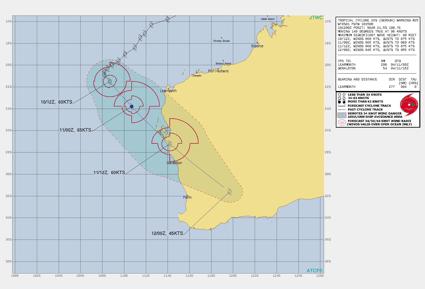
856E8AD3-8417-41BC-8E77-F29D6D827036.gif
回復

使用道具 舉報

簽到天數: 1650 天

[LV.Master]伴壇終老

老農民版夜神月|2021-4-11 04:08 | 顯示全部樓層
本帖最後由 老農民版夜神月 於 2021-4-11 04:18 編輯

JTWC18Z升格C1,定強65KT,21Z新報上望登陸前略微增強達70節 sh2621 (11).gif 26S_101800sair.jpg
20210410.1940.himawari-8.ir.26S.SEROJA.65kts.978mb.22.4S.109.5E.100pc.jpg 20210410.1520.Terra.ir.modir.SEROJA.1KM.jpg LATEST - 2021-04-11T040630.469.jpg
回復

使用道具 舉報

簽到天數: 1650 天

[LV.Master]伴壇終老

老農民版夜神月|2021-4-11 04:11 | 顯示全部樓層
BoM則定強澳2上限60節,預測+6H後將達澳3
IDW27600
TROPICAL CYCLONE TECHNICAL BULLETIN: AUSTRALIA - WESTERN REGION
Issued by AUSTRALIAN BUREAU OF METEOROLOGY TROPICAL CYCLONE WARNING CENTRE
at: 1914 UTC 10/04/2021
Name: Tropical Cyclone Seroja
Identifier: 22U
Data At: 1800 UTC
Latitude: 22.4S
Longitude: 109.6E
Location Accuracy: within 30 nm [55 km]
Movement Towards: southeast [140 deg]
Speed of Movement: 13 knots [24 km/h]
Maximum 10-Minute Wind: 60 knots [110 km/h]
Maximum 3-Second Wind Gust: 85 knots [155 km/h]
Central Pressure: 974 hPa
Radius of 34-knot winds NE quadrant: 120 nm [220 km]
Radius of 34-knot winds SE quadrant: 80 nm [150 km]
Radius of 34-knot winds SW quadrant: 60 nm [110 km]
Radius of 34-knot winds NW quadrant: 80 nm [150 km]
Radius of 48-knot winds NE quadrant: 60 nm [110 km]
Radius of 48-knot winds SE quadrant: 40 nm [75 km]
Radius of 48-knot winds SW quadrant: 30 nm [55 km]
Radius of 48-knot winds NW quadrant: 40 nm [75 km]
Radius of 64-knot winds:
Radius of Maximum Winds: 30 nm [55 km]
Dvorak Intensity Code: T4.0/4.0/D0.5/24HRS STT:S0.0/06HRS
Pressure of outermost isobar: 1000 hPa
Radius of outermost closed isobar: 90 nm [165 km]
FORECAST DATA
Date/Time    : Location    : Loc. Accuracy: Max Wind   : Central Pressure
[UTC]        : degrees     :      nm  [km]: knots[km/h]: hPa
+06:  11/0000: 23.7S 110.6E:     040 [075]:  065  [120]:  971
+12:  11/0600: 25.4S 111.8E:     050 [095]:  065  [120]:  971
+18:  11/1200: 27.2S 113.6E:     055 [105]:  060  [110]:  976
+24:  11/1800: 29.4S 116.2E:     065 [120]:  050  [095]:  984
+36:  12/0600: 33.8S 123.0E:     090 [165]:  030  [055]:  993
+48:  12/1800: 38.1S 130.0E:     125 [235]:  030  [055]:  992
+60:  13/0600:             :              :            :     
+72:  13/1800:             :              :            :     
+96:  14/1800:             :              :            :     
+120: 15/1800:             :              :            :     
REMARKS:
Current position and motion is good based on a 1448Z ASCAT METOP-C pass and a
1707Z GMI microwave image. The microwave pass shows a band of deep convection in
the north and east quadrants wrapping around to the western quadrants to almost
fully enclose the system centre.

Recent satellite imagery has shown a developing convective band with cooling
cloud tops wrapping around the system centre, to give a curved band of 0.9 wrap
and a DT of 4.0, including 0.5 addition for the cold cloud tops. MET is 4.0
based on a D- trend due to the cooling cloud tops, with no adjustment from the
PAT. FT and CI remain at 4.0. ADT is 3.0 [CIMSS] and 3.4 [NESDIS] although both
are using uniform scenes rather than curved band. SATCON at 1217 UTC was 60
knots [one minute mean]. Final intensity is raised to 60kt based on the
improving Dvorak trend.

TC Seroja is being steered towards the southeast by a mid-level high to the
northeast and an approaching mid-latitude trough to the southwest and is
expected to make landfall on the mid-west coast of Western Australia later
today.

CIMSS shear analysis at 15 UTC has eased to 15 knots easterly and is supported
by the recent satellite imagery showing the convection wrapping around the
eastern side, while lower shear is analysed immediately south of the system. The
recent microwave images confirms the low level circulation has remained
symmetrical, so Seroja is forecast to intensify a little in response to these
improving conditions and the lower shear environment along the forecast track in
the next 6-12 hours. It is forecast to reach Category 3 intensity for a period
on Sunday, in particular due to the enhanced wind field expected to develop in
the northeast quadrant as it accelerates towards the southeast.

Seroja is forecast to weaken into a Category 2 system before crossing the coast,
however a Category 3 impact cannot be ruled out, particularly if it follows a
crossing in the Shark Bay area.

Copyright Commonwealth of Australia
==
The next bulletin for this system will be issued by: 11/0130 UTC.
IDW60280 (23).png
Time (AWST)Intensity CategoryLatitude
(decimal deg.)
Longitude
(decimal deg.)
Estimated Position
Accuracy (km)
0hr2 am April 11222.4S109.6E55
+6hr8 am April 11323.7S110.6E75
+12hr2 pm April 11325.4S111.8E95
+18hr8 pm April 11227.2S113.6E105
+24hr2 am April 12229.4S116.2E120
+36hr2 pm April 12tropical low33.8S123.0E165
+48hr2 am April 13tropical low38.1S130.0E235
+60hr2 pm April 13tropical lowXXXXXXXXX
+72hr2 am April 14tropical lowXXXXXXXXX
回復

使用道具 舉報

簽到天數: 483 天

[LV.9]以壇為家II

dom|2021-4-11 10:45 | 顯示全部樓層
本帖最後由 dom 於 2021-4-11 20:34 編輯

JTWC06Z定強70節
26S SEROJA 210411 0600 26.1S 112.0E SHEM 70 972
WTXS31 PGTW 110300
MSGID/GENADMIN/JOINT TYPHOON WRNCEN PEARL HARBOR HI//
SUBJ/TROPICAL CYCLONE 26S (SEROJA) WARNING NR 027//
RMKS/
1. TROPICAL CYCLONE 26S (SEROJA) WARNING NR 027   
   01 ACTIVE TROPICAL CYCLONE IN SOUTHIO
   MAX SUSTAINED WINDS BASED ON ONE-MINUTE AVERAGE
   WIND RADII VALID OVER OPEN WATER ONLY
    ---
   WARNING POSITION:
   110000Z --- NEAR 24.2S 110.5E
     MOVEMENT PAST SIX HOURS - 155 DEGREES AT 18 KTS
     POSITION ACCURATE TO WITHIN 045 NM
     POSITION BASED ON CENTER LOCATED BY SATELLITE
   PRESENT WIND DISTRIBUTION:
   MAX SUSTAINED WINDS - 065 KT, GUSTS 080 KT
   WIND RADII VALID OVER OPEN WATER ONLY
   BECOMING EXTRATROPICAL
   RADIUS OF 064 KT WINDS - 035 NM NORTHEAST QUADRANT
                            035 NM SOUTHEAST QUADRANT
                            000 NM SOUTHWEST QUADRANT
                            000 NM NORTHWEST QUADRANT
   RADIUS OF 050 KT WINDS - 055 NM NORTHEAST QUADRANT
                            055 NM SOUTHEAST QUADRANT
                            025 NM SOUTHWEST QUADRANT
                            040 NM NORTHWEST QUADRANT
   RADIUS OF 034 KT WINDS - 110 NM NORTHEAST QUADRANT
                            095 NM SOUTHEAST QUADRANT
                            060 NM SOUTHWEST QUADRANT
                            090 NM NORTHWEST QUADRANT
   REPEAT POSIT: 24.2S 110.5E
    ---
   FORECASTS:
   12 HRS, VALID AT:
   111200Z --- 28.0S 114.2E
   MAX SUSTAINED WINDS - 060 KT, GUSTS 075 KT
   WIND RADII VALID OVER OPEN WATER ONLY
   BECOMING EXTRATROPICAL
   RADIUS OF 050 KT WINDS - 060 NM NORTHEAST QUADRANT
                            040 NM SOUTHEAST QUADRANT
                            030 NM SOUTHWEST QUADRANT
                            050 NM NORTHWEST QUADRANT
   RADIUS OF 034 KT WINDS - 120 NM NORTHEAST QUADRANT
                            090 NM SOUTHEAST QUADRANT
                            060 NM SOUTHWEST QUADRANT
                            110 NM NORTHWEST QUADRANT
   VECTOR TO 24 HR POSIT: 135 DEG/ 33 KTS
    ---
   24 HRS, VALID AT:
   120000Z --- 32.4S 120.0E
   MAX SUSTAINED WINDS - 045 KT, GUSTS 055 KT
   WIND RADII VALID OVER OPEN WATER ONLY
   EXTRATROPICAL
    ---
REMARKS:
110300Z POSITION NEAR 25.1S 111.4E.
11APR21. TROPICAL CYCLONE (TC) 26S (SEROJA), LOCATED APPROXIMATELY
229 NM WEST-SOUTHWEST OF LEARMONTH, AUSTRALIA, HAS TRACKED SOUTH-
SOUTHEASTWARD AT 18 KNOTS OVER THE PAST SIX HOURS. ANIMATED
MULTISPECTRAL SATELLITE IMAGERY DEPICTS TIGHTLY-CURVED BANDING
WRAPPING AROUND A WEAK, FORMATIVE EYE. A 102111Z SSMIS 91GHZ
MICROWAVE IMAGE REVEALS A COMPACT SYSTEM WITH DEEP CONVECTIVE
BANDING PRIMARILY OVER THE SOUTHERN SEMICIRCLE WRAPPING INTO THE
NORTH QUADRANT. OVERALL, THERE IS GOOD CONFIDENCE IN THE INITIAL
POSITION. THE INITIAL INTENSITY REMAINS ASSESSED AT 65 KNOTS BASED
ON DVORAK INTENSITY ESTIMATES RANGING FROM T4.0 (65 KNOTS) TO T4.5
(77 KNOTS). TC 26S IS EXPECTED TO ACCELERATE SOUTHEASTWARD THROUGH
THE FORECAST PERIOD WITHIN THE MIDLATITUDE WESTERLY FLOW POLEWARD OF
A DEEP-LAYERED SUBTROPICAL RIDGE POSITIONED TO THE NORTHEAST. THE
SYSTEM HAS COMMENCED EXTRA-TROPICAL TRANSITION (ETT) AND WILL
QUICKLY COMPLETE ETT BY TAU 24 AS IT BECOMES EMBEDDED WITHIN
THE WESTERLIES AND GAINS FRONTAL CHARACTERISTICS. TC 26S WILL WEAKEN
RAPIDLY AFTER TAU 12 AS IT ENCOUNTERS STRONG VWS (25-35 KNOTS) AND
TRACKS OVER SOUTHWESTERN AUSTRALIA. MAXIMUM SIGNIFICANT WAVE HEIGHT
AT 110000Z IS 27 FEET. NEXT WARNINGS AT 110900Z, 111500Z AND
112100Z.//
NNNN
102012sflrq7jgw5gup5gr.gif
回復

使用道具 舉報

簽到天數: 483 天

[LV.9]以壇為家II

dom|2021-4-11 14:05 | 顯示全部樓層
登陸前最後掙扎, BoM升格澳式C3
Details of Severe Tropical Cyclone Seroja at 11:00 am AWST:

Intensity: category 3, sustained winds near the centre of 120 kilometres per hour with wind gusts to 165 kilometres per hour.
Location: within 30 kilometres of 25.2 degrees South, 111.2 degrees East , 250 kilometres west northwest of Denham and 405 kilometres northwest of Kalbarri .
Movement: south southeast at 36 kilometres per hour .

Tropical Cyclone Seroja is moving rapidly towards the southeast, approaching the west coast of WA and will begin impacting coastal communties in the next few hours.

Seroja has intensified to Severe Category 3, It is likely to weaken to Category 2 prior to crossing the coast, though a Severe Category 3 impact remains a slight risk.

Seroja is accelerating southeastwards towards the coast and is likely to be travelling at around 50 kilometres per hour as it crosses the coast. . Significant impacts are expected to extend well inland from the coast through to Wheat Belt communities during Sunday night.

The cyclone will weaken as it moves inland on Monday but is still likely to result in damaging wind gusts, particularly to the north and east of the track, and heavy rain close to the track, as it moves through the eastern Wheat Belt, southern Goldfields and South East Coastal district.
IDW60280.png b3.png b13bd.png b13rbtop.png

回復

使用道具 舉報

簽到天數: 483 天

[LV.9]以壇為家II

dom|2021-4-11 19:09 | 顯示全部樓層
即將登陸, 發展出MG環OW眼 9D8213E1-700B-490B-9A6A-B264F0C4F95C.png 2E64F7D0-7B27-4E92-8E1D-3D117177904C.png 3FD5A89B-CF19-4D3F-A034-BA13BB5A4B14.png 8D61D945-8FE3-45C2-A0DA-77895E53A62D.png
回復

使用道具 舉報

快速回覆
您需要登錄後才可以回帖 登錄 | 立即加入

本版積分規則

本平台僅供學術討論之用,預報應以氣象局為準

威普網站虛擬主機贊助公司

臺灣第一個天氣類型社群平台 即時天氣資訊、精準颱風動態

線上客服
FB傳送訊息
廣告行銷
精準行銷 物超所值
官方粉專
發佈 快速回復 返回頂部 返回列表