開啟輔助訪問
 找回密碼
 立即加入

91L 登陸德州

簽到天數: 2414 天

[LV.Master]伴壇終老

2021-5-21 09:47 | 顯示全部樓層
  基本資料  
編號               :91 L
擾動編號日期 :2021 05 21 08
撤編日期        :2021 05 22 15
91L.INVEST.20kts.1010mb.24.3N.93.7W

20210521.0120.goes-16.ir.91L.INVEST.20kts.1010mb.24.3N.93.7W.100pc.jpg

  NHC:20%  
2. A disorganized area of cloudiness and thunderstorms over the
western Gulf of Mexico is associated with a surface trough of low
pressure. Conditions are expected to be marginally conducive for
some development over the next day or so before the disturbance
moves inland over the northwestern Gulf coast late Friday or Friday
night. Regardless of development, the system could produce heavy
rainfall over portions of southeastern Texas and southwestern
Louisiana on Friday and through the weekend.  Additional information
on the rainfall and flooding potential can be found in products
issued by your local National Weather Service Forecast Office.
* Formation chance through 48 hours...low...20 percent.
* Formation chance through 5 days...low...20 percent.

two_atl_2d2.png

評分

參與人數 1水氣能量 +15 +1 收起 理由
t02436 + 15 + 1

查看全部評分

回復

使用道具 舉報

簽到天數: 483 天

[LV.9]以壇為家II

dom|2021-5-21 20:03 | 顯示全部樓層
展望提升至Medium
ZCZC MIATWOAT ALL
TTAA00 KNHC DDHHMM

Tropical Weather Outlook
NWS National Hurricane Center Miami FL
800 AM EDT Fri May 21 2021

For the North Atlantic...Caribbean Sea and the Gulf of Mexico:

1. Showers and thunderstorms associated with a non-tropical low
pressure area centered about 450 miles east-northeast of Bermuda
have become better organized during the past several hours.  The
low has not yet acquired subtropical storm characteristics.  
However, if current trends continue advisories could be initiated
on the system later today or tonight as it moves westward
to west-southwestward to the northeast of Bermuda.  Subsequently,
the low is forecast to move northeastward into a more hostile
environment by Saturday night or Sunday.  Additional information on
this low pressure area can be found in High Seas forecasts issued by
the NOAA Ocean Prediction Center and forecast products, including a
tropical storm watch, issued by the Bermuda Weather Service.
* Formation chance through 48 hours...high...90 percent.
* Formation chance through 5 days...high...90 percent.

2. Recent satellite imagery suggests that a low-level circulation is
forming associated with the mid- to upper-level disturbance over the
western Gulf of Mexico. However, shower and thunderstorm activity
remains disorganized. Environmental conditions are expected to be
marginally conducive for development, and a short-lived tropical
depression or storm could form before the disturbance moves inland
over the northwestern Gulf coast tonight. Regardless of development,
the system could produce heavy rainfall over portions of
southeastern Texas and southwestern Louisiana during the next few
days.  Additional information on the rainfall and flooding potential
can be found in products issued by your local National Weather
Service Forecast Office.
* Formation chance through 48 hours...medium...40 percent.
* Formation chance through 5 days...medium...40 percent.

High Seas Forecasts issued by the National Weather Service can be
found under AWIPS header NFDHSFAT1, WMO header FZNT01 KWBC, and
online at ocean.weather.gov/shtml/NFDHSFAT1.php

Forecaster Beven/Papin
45D47776-CE8C-4304-9D44-5C1140F383EE.png
回復

使用道具 舉報

簽到天數: 1650 天

[LV.Master]伴壇終老

老農民版夜神月|2021-5-21 20:04 | 顯示全部樓層
本帖最後由 老農民版夜神月 於 2021-5-21 20:13 編輯

NHC展望提升至Medium,40%
2. Recent satellite imagery suggests that a low-level circulation is
forming associated with the mid- to upper-level disturbance over the
western Gulf of Mexico. However, shower and thunderstorm activity
remains disorganized. Environmental conditions are expected to be
marginally conducive for development, and a short-lived tropical
depression or storm could form before the disturbance moves inland
over the northwestern Gulf coast tonight. Regardless of development,
the system could produce heavy rainfall over portions of
southeastern Texas and southwestern Louisiana during the next few
days.  Additional information on the rainfall and flooding potential
can be found in products issued by your local National Weather
Service Forecast Office.
* Formation chance through 48 hours...medium...40 percent.
* Formation chance through 5 days...medium...40 percent.

two_atl_2d2.png
two_atl_5d2.png 20210521.0816.gw1.89pct89h89v.91L.INVEST.20kts.1011mb.24.3N.93.7W.79pc.jpg LATEST (2).jpg
回復

使用道具 舉報

簽到天數: 1650 天

[LV.Master]伴壇終老

老農民版夜神月|2021-5-21 20:15 | 顯示全部樓層
本帖最後由 老農民版夜神月 於 2021-5-21 20:18 編輯

06Z最新數值預報 91L_tracks_latest.png
91L_intensity_latest.png 91L_gefs_latest.png
回復

使用道具 舉報

簽到天數: 1650 天

[LV.Master]伴壇終老

老農民版夜神月|2021-5-22 03:36 | 顯示全部樓層
NHC展望提升至60%
2. Surface observations and recent satellite wind data indicate that a
well-defined low pressure system over the western Gulf of Mexico has
winds of 30-35 mph near and east of the center. The associated
shower and thunderstorm activity remains limited, but any increase
in this activity may result in the formation of a short-lived
tropical depression or storm before the system moves inland over the
northwestern Gulf coast tonight, and potential tropical cyclone
advisories may be needed as early as this afternoon.  Regardless of
development, the system could produce heavy rainfall over portions
of southeastern Texas and southwestern Louisiana through Saturday.  
Given the complete saturation of soils with ongoing river flooding
along the Texas and Louisiana coastal areas, heavy rain could lead
to flash, urban, and additional riverine flooding across this
region.  Additional information on the rainfall and flooding
potential can be found in products issued by your local National
Weather Service Forecast Office.
* Formation chance through 48 hours...medium...60 percent.
* Formation chance through 5 days...medium...60 percent.
two_atl_2d0 (2).png two_atl_2d2 (1).png
two_atl_5d2 (1).png
回復

使用道具 舉報

簽到天數: 1650 天

[LV.Master]伴壇終老

老農民版夜神月|2021-5-22 04:37 | 顯示全部樓層
FWC-N發布TCFA
WTNT22 KNGU 212000
SUBJ/TROPICAL CYCLONE FORMATION ALERT (91L) //
REF/A/FLEWEACEN NORFOLK VA/202200Z MAY 21//
AMPN/REF IS TROPICAL CYCLONE FORMATION ALERT (WTNT21 KNGU 202200)//
RMKS/1. FORMATION OF A SIGNIFICANT TROPICAL CYCLONE IS POSSIBLE
WITHIN 100 NM EITHER SIDE OF A LINE FROM 26.4N 94.2W TO 28.5N 95.5W
WITHIN THE NEXT 24 HOURS. AVAILABLE DATA DOES NOT JUSTIFY
ISSUANCE OF NUMBERED TROPICAL CYCLONE WARNINGS AT THIS TIME.
WINDS IN THE AREA ARE ESTIMATED TO BE 30 TO 40 KNOTS. METSAT
IMAGERY AT 211800Z INDICATES THAT A CIRCULATION CENTER IS LOCATED
NEAR 26.4N 94.2W. THE SYSTEM IS MOVING NORTHWESTWARD AT 06 KNOTS.
2. SATELLITE DERIVED WIND DATA, AND MARINE SURFACE OBSERVATIONS
INDICATE THAT A LOW PRESSURE SYSTEM SITUATED OVER THE WESTERN
PORTION OF THE GULF OF MEXICO IS PRODUCING WINDS 25-30 KNOTS WELL TO
THE NORTHEAST OF THE SURFACE CENTER. SHOWER AND THUNDERSTORM
ACTIVITY ASSOCIATED WITH THE LOW IS LIMITED AND IS LOCATED
IN THE NORTHERN PERIPHERY OF THE SYSTEM. ANY INCREASE IN THIS
SPARSE CONVECTIVE ACTIVITY COULD RESULT IN THE FORMATION OF A
SHORT-LIVED DEPRESSION OR STORM BEFORE IT MOVES INLAND OVER THE
TEXAS COAST LATER TONIGHT.
3. THIS ALERT WILL BE REISSUED, UPGRADED TO WARNING OR CANCELLED
BY 222000Z.
4. SEE REF A FOR DETAILS ON A TROPICAL CYCLONE FORMATION ALERT 90L
LOCATED NEAR 34.4N 53.7W.//
BT
#0001
NNNN
al912021.gif LATEST (5).jpg
LATEST (6).jpg
回復

使用道具 舉報

簽到天數: 483 天

[LV.9]以壇為家II

dom|2021-5-22 13:53 | 顯示全部樓層
展望降至Low
ZCZC MIATWOAT ALL
TTAA00 KNHC DDHHMM

Tropical Weather Outlook
NWS National Hurricane Center Miami FL
200 AM EDT Sat May 22 2021

For the North Atlantic...Caribbean Sea and the Gulf of Mexico:

1. Satellite images indicate that the well-defined low pressure area
located about 200 miles northeast of Bermuda continues to produce
gale-force winds and appears to have acquired subtropical
characteristics.  In addition, thunderstorm activity has been
gradually increasing near the center, and if that trend continues
advisories will be issued later this morning.  The low is expected
to move little today, remaining in the vicinity of Bermuda, but it
is forecast to turn northeastward and move into a more hostile
environment on Sunday.  Additional information on this low pressure
area can be found in High Seas forecasts issued by the NOAA Ocean
Prediction Center and forecast products, including a tropical storm
watch, issued by the Bermuda Weather Service.
* Formation chance through 48 hours...high...near 100 percent.
* Formation chance through 5 days...high...near 100 percent.

2. A well-defined low pressure area is approaching the Texas coast and
is now about 50 miles east-southeast of Corpus Christi.  Surface
observations and satellite wind data indicate that the system
continues to produce winds of about 35 mph near and to the east of
its center, but the associated shower and thunderstorm activity
remains limited. Since the low is expected to move inland during
the next several hours, the chances of it becoming a tropical
depression or storm are decreasing.  Regardless of development,
the system could produce heavy rainfall over portions of
southeastern Texas and southwestern Louisiana today. Given the
complete saturation of soils with ongoing river flooding along the
Texas and Louisiana coastal areas, heavy rain could lead to flash,
urban, and additional riverine flooding across this region.  
Additional information on the rainfall and flooding potential can be
found in products issued by your local National Weather Service
Forecast Office.
* Formation chance through 48 hours...low...30 percent.
* Formation chance through 5 days...low...30 percent.

High Seas Forecasts issued by the National Weather Service can be
found under AWIPS header NFDHSFAT1, WMO header FZNT01 KWBC, and
online at ocean.weather.gov/shtml/NFDHSFAT1.php

Forecaster Cangialosi
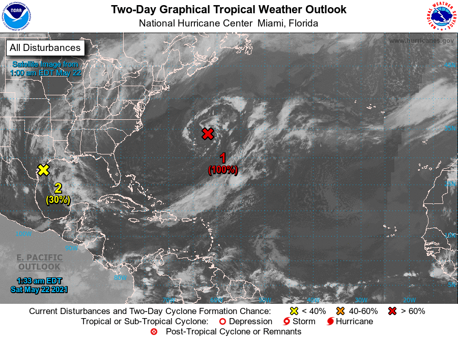
0C57947A-A0B0-4C6F-AFC9-2B924C39D481.png
回復

使用道具 舉報

簽到天數: 483 天

[LV.9]以壇為家II

dom|2021-5-22 20:18 | 顯示全部樓層
NHC12Z判定登陸得克薩斯州
ZCZC MIATWOAT ALL
TTAA00 KNHC DDHHMM

Tropical Weather Outlook
NWS National Hurricane Center Miami FL
800 AM EDT Sat May 22 2021

For the North Atlantic...Caribbean Sea and the Gulf of Mexico:

The National Hurricane Center is issuing advisories on recently
developed Subtropical Storm Ana, located about 180 miles northeast
of Bermuda.

1. Surface observations and radar data indicate that the area of low
pressure previously over the northwestern Gulf of Mexico has moved
inland over southeastern Texas.  Therefore, tropical cyclone
formation is not expected.  However, the system could produce heavy
rainfall over portions of southeastern Texas and southwestern
Louisiana today.  Given the complete saturation of soils with
ongoing river flooding along the Texas and Louisiana coastal areas,
these rains could lead to flash, urban, and additional riverine
flooding across this region.  Additional information on the rainfall
and flooding potential can be found in products issued by your
local National Weather Service Forecast Office.
* Formation chance through 48 hours...low...near 0 percent.
* Formation chance through 5 days...low...near 0 percent.

Public Advisories on Subtropical Storm Ana are issued under WMO
header WTNT31 KNHC and under AWIPS header MIATCPAT1.
Forecast/Advisories on Subtropical Storm Ana are issued under WMO
header WTNT21 KNHC and under AWIPS header MIATCMAT1.

Forecaster Beven
CF01A0AE-1EB9-415F-BB51-0A6887581842.png
回復

使用道具 舉報

12下一頁
快速回覆
您需要登錄後才可以回帖 登錄 | 立即加入

本版積分規則

本平台僅供學術討論之用,預報應以氣象局為準

威普網站虛擬主機贊助公司

臺灣第一個天氣類型社群平台 即時天氣資訊、精準颱風動態

線上客服
FB傳送訊息
廣告行銷
精準行銷 物超所值
官方粉專
發佈 快速回復 返回頂部 返回列表