開啟輔助訪問
 找回密碼
 立即加入

93E

簽到天數: 1650 天

[LV.Master]伴壇終老

2021-6-11 07:06 | 顯示全部樓層
  基本資料  
編號               :93 E
擾動編號日期 :2021 06 11 06
撤編日期        :2021 06 14 05
93E.INVEST.15kts.1005mb.12.7N.98.7W
20210610.2240.goes-17.vis.2km.93E.INVEST.15kts.1005mb.12.7N.98.7W.pc.jpg


  NHC:0%
2. A broad trough of low pressure located several hundred miles south
of the coast of southern Mexico is producing a large area of
disorganized showers and thunderstorms. Environmental conditions
appear conducive for gradual development, and a tropical depression
could form this weekend or early next week while the system drifts
generally northward.  Regardless of development, heavy rainfall
could occur over portions of Central America and southern Mexico
through early next week.  See products from your local
meteorological service for more information.
* Formation chance through 48 hours...low...near 0 percent.
* Formation chance through 5 days...medium...40 percent.

two_pac_2d0 (4).png two_pac_2d2 (3).png
two_pac_5d0 (2).png two_pac_5d2 (1).png

評分

參與人數 1水氣能量 +15 +1 收起 理由
周子堯@FB + 15 + 1 熱帶擾動首帖

查看全部評分

回復

使用道具 舉報

簽到天數: 483 天

[LV.9]以壇為家II

dom|2021-6-11 20:02 | 顯示全部樓層
NHC評級提升至Medium
ZCZC MIATWOEP ALL
TTAA00 KNHC DDHHMM

Tropical Weather Outlook
NWS National Hurricane Center Miami FL
500 AM PDT Fri Jun 11 2021

For the eastern North Pacific...east of 140 degrees west longitude:

1. Showers and thunderstorms have become more concentrated this morning
in association with a broad area of low pressure a couple hundred
miles south-southwest of Puerto Angel, Mexico. Environmental
conditions appear conducive for additional development, and a
tropical depression could form by this weekend while the system
drifts north-northeastward.  Heavy rainfall will be possible over
portions of Central America and southern Mexico through early next
week. See products from your local meteorological service for more
information.
* Formation chance through 48 hours...medium...40 percent.
* Formation chance through 5 days...medium...50 percent.

2. A broad area of low pressure located about 1100 miles southwest of
the southern tip of the Baja California peninsula continues to
produce disorganized showers and thunderstorms.  Environmental
conditions appear marginally conducive for some gradual development
over the next few days, and a tropical depression could form by
early next week while the system moves slowly westward.
* Formation chance through 48 hours...low...30 percent.
* Formation chance through 5 days...medium...40 percent.

Forecaster Latto
3D84C85E-16DF-4D31-B091-D01BD558EF61.png
回復

使用道具 舉報

簽到天數: 483 天

[LV.9]以壇為家II

dom|2021-6-13 08:05 | 顯示全部樓層
NHC展望降至Low
ZCZC MIATWOEP ALL
TTAA00 KNHC DDHHMM

Tropical Weather Outlook
NWS National Hurricane Center Miami FL
500 PM PDT Sat Jun 12 2021

For the eastern North Pacific...east of 140 degrees west longitude:

The National Hurricane Center has initiated advisories on newly
formed Tropical Depression Three-E, located more than 1000 miles
southwest of the southern tip of the Baja California peninsula.

1. Showers and thunderstorms remain poorly organized in association
with a weak area of low pressure located about a hundred miles
south-southwest of Puerto Angel, Mexico. Environmental conditions
appear only marginally conducive for additional development over
the next day or so. By early next week, the system is forecast to
interact with land and a larger disturbance developing to its north,
and further development is not anticipated. Regardless of
development, heavy rainfall will be possible over portions of
Central America and southern Mexico through early next week. See
products from your local meteorological service for more
information.
* Formation chance through 48 hours...low...30 percent.
* Formation chance through 5 days...low...30 percent.

Public Advisories on Tropical Depression Three-E are issued under
WMO header WTPZ33 KNHC and under AWIPS header MIATCPEP3.
Forecast/Advisories on Tropical Depression Three-E are issued under
WMO header WTPZ23 KNHC and under AWIPS header MIATCMEP3.

Forecaster Papin/Pasch
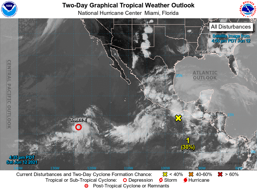
E78873E9-1C35-49F0-94D0-3DD27F543A3D.png
回復

使用道具 舉報

簽到天數: 1650 天

[LV.Master]伴壇終老

老農民版夜神月|2021-6-14 04:55 | 顯示全部樓層
NHC展望降至0%
1. Satellite images indicate that the weak area of low pressure
previously located about a hundred miles south-southwest of Puerto
Angel, Mexico has dissipated. Environmental conditions do not appear
conducive for the low to re-develop, and therefore formation of a
tropical cyclone is not expected. Regardless of development, heavy
rainfall is possible over portions of Central America and southern
Mexico through early this week. See products from your local
meteorological service for more information.
* Formation chance through 48 hours...low...near 0 percent.
* Formation chance through 5 days...low...near 0 percent.
two_pac_2d0 (7).png two_pac_2d1 (13).png
two_pac_5d1 (13).png
回復

使用道具 舉報

快速回覆
您需要登錄後才可以回帖 登錄 | 立即加入

本版積分規則

本平台僅供學術討論之用,預報應以氣象局為準

威普網站虛擬主機贊助公司

臺灣第一個天氣類型社群平台 即時天氣資訊、精準颱風動態

線上客服
FB傳送訊息
廣告行銷
精準行銷 物超所值
官方粉專
發佈 快速回復 返回頂部 返回列表