開啟輔助訪問
 找回密碼
 立即加入

15E.Newton 整合發展中

簽到天數: 601 天

[LV.9]以壇為家II

2022-9-21 10:30 | 顯示全部樓層
基本資料  
編號    :96 E
擾動編號日期:2022 09 21 09
撤編日期  :2022 00 00 00
96E.INVEST.25kts-1008mb-16.7N-102.1W
20220921.0030.goes-17.ir.96E.INVEST.25kts.1008mb.16.7N.102.1W.100pc.jpg
1. South of Southwestern Mexico:
Shower and thunderstorm activity associated with an area of low
pressure located just off the coast of southwestern Mexico has shown
signs of becoming better organized today. Environmental conditions
are expected to support some additional development of this system
as it moves west-northwestward near or just south of the
southwestern coast of Mexico today and tonight, and then away from
the coast of Mexico through the end of the week.
* Formation chance through 48 hours...low...20 percent.
* Formation chance through 5 days...low...30 percent.

two_pac_2d1.png

評分

參與人數 1水氣能量 +15 +1 收起 理由
t02436 + 15 + 1

查看全部評分

回復

使用道具 舉報

簽到天數: 601 天

[LV.9]以壇為家II

霧峰追風者|2022-9-21 18:57 | 顯示全部樓層
two_pac_2d1.png
1. 1. South of Southwestern Mexico:
Shower and thunderstorm activity associated with an area of low
pressure located just off the coast of southwestern Mexico continues
to show signs of organization. Environmental conditions appear
generally conducive for additional development and a tropical
depression could form from this system over the next several days.
This system is expected to move west-northwestward near or just
south of the southwestern coast of Mexico over the next day or so,
and then away from the coast of Mexico through the end of the week.
* Formation chance through 48 hours...medium...40 percent.
* Formation chance through 5 days...medium...50 percent.


回復

使用道具 舉報

簽到天數: 601 天

[LV.9]以壇為家II

霧峰追風者|2022-9-22 10:13 | 顯示全部樓層
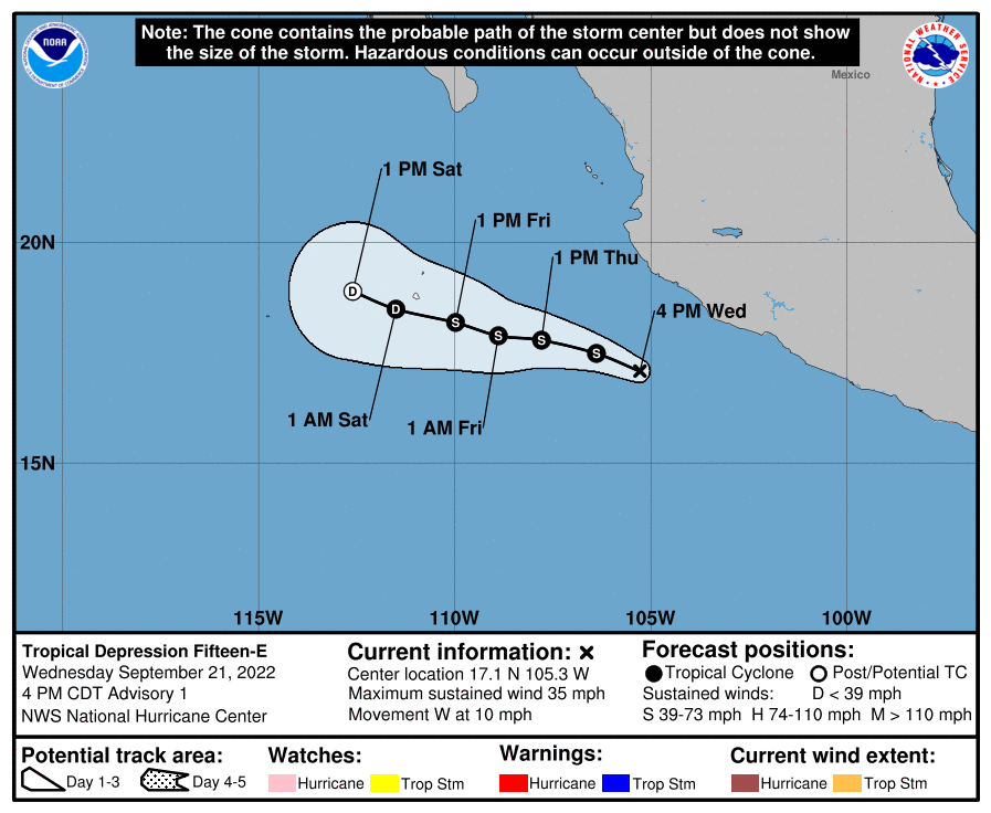
204249_5day_cone_with_line_and_wind.png
000
WTPZ45 KNHC 212042
TCDEP5

Tropical Depression Fifteen-E Discussion Number   1
NWS National Hurricane Center Miami FL       EP152022
400 PM CDT Wed Sep 21 2022

A new tropical depression has formed in the east Pacific basin.  
The satellite presentation of now Tropical Depression Fifteen-E
has improved over the past 24 hours.  Visible imagery shows decent
upper-level outflow in the western semicircle and cold cloud tops as
low as -70 degrees C.  Due to the increase in convective
organization, the initial intensity is set to 30 kt, slightly
higher than the subjective Dvorak estimates from TAFB and SAB.

The depression is moving just north of west at 275/9 kt. It is
moving along the southwest periphery of a mid-level ridge centered
over Texas.  This ridge is expected to steer the system to the
west-northwest for the next couple of days at a gradually slower
forward speed.  The model guidance is relatively tightly
clustered and the NHC track forecast is close to the multi-model
consensus aids.  

The environmental conditions are forecast to be marginally
conducive for slight development over the next couple days.
Oceanic surface temperatures, atmospheric moisture and vertical
wind shear are likely to allow the depression to reach and maintain
tropical cyclone strength for the next couple of days.  Beyond that
time frame, the cyclone is forecast to traverse cooler waters and
enter a drier, more stable environment.  The system is expected to
become a remnant low by 72 hours and open into a trough shortly
thereafter.  


FORECAST POSITIONS AND MAX WINDS

INIT  21/2100Z 17.1N 105.3W   30 KT  35 MPH
12H  22/0600Z 17.5N 106.4W   35 KT  40 MPH
24H  22/1800Z 17.8N 107.8W   35 KT  40 MPH
36H  23/0600Z 17.9N 108.9W   35 KT  40 MPH
48H  23/1800Z 18.2N 110.0W   35 KT  40 MPH
60H  24/0600Z 18.5N 111.5W   30 KT  35 MPH
72H  24/1800Z 18.9N 112.6W   25 KT  30 MPH...POST-TROP/REMNT LOW
96H  25/1800Z...DISSIPATED

$$
Forecaster Bucci/Jelsema


回復

使用道具 舉報

快速回覆
您需要登錄後才可以回帖 登錄 | 立即加入

本版積分規則

霧峰追風者

    主題

    帖子

    221萬

    積分

    16級[四級颶風]

    Rank: 16Rank: 16Rank: 16Rank: 16

16級[四級颶風]

發訊息

本平台僅供學術討論之用,預報應以氣象局為準

威普網站虛擬主機贊助公司

臺灣第一個天氣類型社群平台 即時天氣資訊、精準颱風動態

線上客服
FB傳送訊息
廣告行銷
精準行銷 物超所值
官方粉專
發佈 快速回復 返回頂部 返回列表