簽到天數: 3291 天 [LV.Master]伴壇終老
|
 t02436|2022-10-12 07:31
|
顯示全部樓層
000
WTNT44 KNHC 112053
TCDAT4
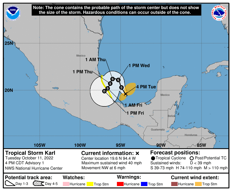
Tropical Storm Karl Discussion Number 1
NWS National Hurricane Center Miami FL AL142022
400 PM CDT Tue Oct 11 2022
Tropical Storm Karl has formed over the Bay of Campeche. Aircraft
and scatterometer data show a closed circulation with a relatively
large radius of maximum winds and a broad area of light and variable
winds near the center. The Air Force Hurricane Hunter
reconnaissance aircraft found believable SFMR wind speeds of 35 kt
and flight-level winds up to 46 kt while investigating the system.
The scatterometer data also showed a large area of 30-35 kt winds to
the north of the center. The initial intensity is set to 35 kt
based on these data.
Karl is moving slowly northwestward at an estimated 5 kt. The storm
is embedded in a high pressure system, and this motion is expected
to continue for the next day or so. Thereafter, the ridge is likely
to build westward and steer the cyclone southwestward into the coast
of Mexico in a few days. The official forecast is close to the
consensus guidance, though this is an uncertain forecast due to the
spread in the forecast track models near landfall.
Atmospheric and oceanic conditions are forecast to be conducive for
Karl during the next day or so. This should allow Karl to
strengthen before global models suggest the vertical wind shear
increases and causes gradual weakening before landfall. Rapid decay
is expected once the storm moves inland due to the mountainous
terrain. The NHC intensity forecast peaks at 45 kt in 24 h which is
close to the SHIPS guidance, though all of guidance is clustered
near this value.
Key Messages:
1. Heavy rainfall could produce flash flooding in the Isthmus of
Tehuantepec and in the southern Sierra Madre Oriental mountains and
adjacent coastal areas with possible mudslides in areas of higher
terrain.
2. Tropical storm conditions are possible in the watch area in
Mexico starting Thursday.
FORECAST POSITIONS AND MAX WINDS
INIT 11/2100Z 19.6N 94.4W 35 KT 40 MPH
12H 12/0600Z 20.3N 94.9W 40 KT 45 MPH
24H 12/1800Z 21.1N 95.3W 45 KT 50 MPH
36H 13/0600Z 21.2N 96.0W 45 KT 50 MPH
48H 13/1800Z 20.7N 96.3W 40 KT 45 MPH
60H 14/0600Z 20.2N 96.6W 35 KT 40 MPH
72H 14/1800Z 19.9N 97.0W 25 KT 30 MPH...INLAND
96H 15/1800Z...DISSIPATED
$$
Forecaster Bucci/Blake

|
|