簽到天數: 2141 天 [LV.Master]伴壇終老
|
 周子堯@FB|2023-7-13 14:47
|
顯示全部樓層
JTWC 10/18Z發布TCFA
NHC 11/18Z升格TD-03E,12/09Z命名Calvin
1. FORMATION OF A SIGNIFICANT TROPICAL CYCLONE IS POSSIBLE WITHIN 160 NM
EITHER SIDE OF A LINE FROM 10.4N 99.6W TO 12.1N 109.4W WITHIN THE NEXT 12
TO 24 HOURS. AVAILABLE DATA DOES NOT JUSTIFY ISSUANCE OF NUMBERED
TROPICAL CYCLONE WARNINGS AT THIS TIME. WINDS IN THE AREA ARE ESTIMATED
TO BE 22 TO 28 KNOTS. METSAT IMAGERY AT 101800Z INDICATES THAT A
CIRCULATION CENTER IS LOCATED NEAR 10.5N 100.2W. THE SYSTEM IS MOVING
WEST-NORTHWESTWARD AT 13 KNOTS.
2. REMARKS: AN AREA OF CONVECTION (INVEST 94E) IS LOCATED NEAR 10.5N
100.2W, APPROXIMATELY 569NM SOUTH-SOUTHEAST OF MANZANILLO, MEXICO.
ANIMATED MULTISPECTRAL SATELLITE IMAGERY (MSI) DEPICTS A CONSOLIDATING
LOW LEVEL CIRCULATION (LLC) OBSCURED BY DENSE CONVECTION WITH FRAGMENTED
BANDING ON THE WESTERN AND NORTHEASTERN PERIPHERIES WRAPPING INTO THE
LLC. A 101646Z ASCAT METOP-B SCATTEROMETER BULLSEYE REVEALS THE LOW LEVEL
CIRCULATION CENTER (LLCC) WITH WINDS OF 15-20 KNOTS ON THE NORTHWESTERN
PERIPHERY WITH EMBEDDED AREAS OF 25 KNOTS. ENVIRONMENTAL ANALYSIS
INDICATES A FAVORABLE AREA OF DEVELOPMENT DEFINED BY FAIR DIFFLUENT
OUTFLOW ALOFT, LOW (5-10KT) VERTICAL WIND SHEAR (VWS), AND VERY WARM
(29-30C) SEA SURFACE TEMPERATURES. GLOBAL MODELS ARE IN AGREEMENT THAT
INVEST 94E WITH CONTINUE ON A WEST-NORTHWEST TRACK OVER THE NEXT 24-48
HOURS. MAXIMUM SUSTAINED SURFACE WINDS ARE ESTIMATED AT 22 TO 28 KNOTS.
MINIMUM SEA LEVEL PRESSURE IS ESTIMATED TO BE NEAR 1001 MB. THE POTENTIAL
FOR THE DEVELOPMENT OF A SIGNIFICANT TROPICAL CYCLONE WITHIN THE NEXT 24
HOURS IS HIGH. 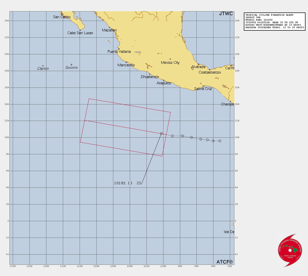
WTPZ43 KNHC 112033
TCDEP3
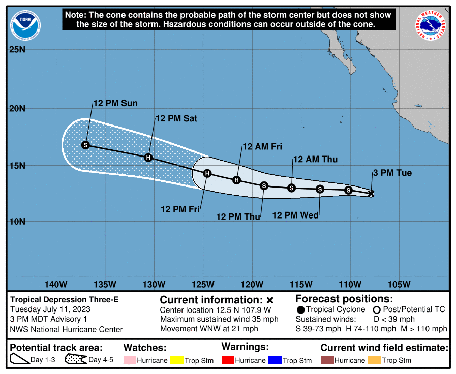
Tropical Depression Three-E Discussion Number 1
NWS National Hurricane Center Miami FL EP032023
300 PM MDT Tue Jul 11 2023
Deep convection has been increasing in intensity and coverage
near the center of the system during the past several hours.
Recent ASCAT scatterometer passes indicate that the low has
developed a well-defined center and maximum winds of around 30 kt
on its west side. The estimated center position is a bit uncertain
since there are considerable convective clouds obscuring it.
The low now meets the criteria of a tropical depression, and the
initial intensity is estimated to be 30 kt based on the ASCAT data
and a Dvorak classification from TAFB.
The depression is moving quickly to the west-northwest and the
initial motion is estimated to be 290/18 kt. The steering pattern
for the depression seems fairly straightforward. A strong mid-level
ridge to the north of the system is expected to remain in place
during the next several days. Therefore, the west-northwestward
motion will continue throughout the forecast period. The models are
in relatively good agreement, and the NHC track forecast lies near
the various consensus aids.
Tropical Depression Three-E is currently over warm SSTs and will
remain over warm ocean temperatures through the next several days.
Dynamical guidance indicates that the depression is currently
dealing with some northeasterly shear, and that shear will continue
during the next day or so. Thereafter, vertical wind shear is
expected to decrease for several days. This lower wind shear and
warm SSTs will foster a conducive environment for strengthening
through the end of the week. The intensity forecast reflects gradual
strengthening in the short-term, with the system strengthening into
a hurricane in about 3 days. Towards the end of the forecast period,
the tropical cyclone will be moving over cooling SSTs, which should
end the strengthening phase and cause gradual weakening.
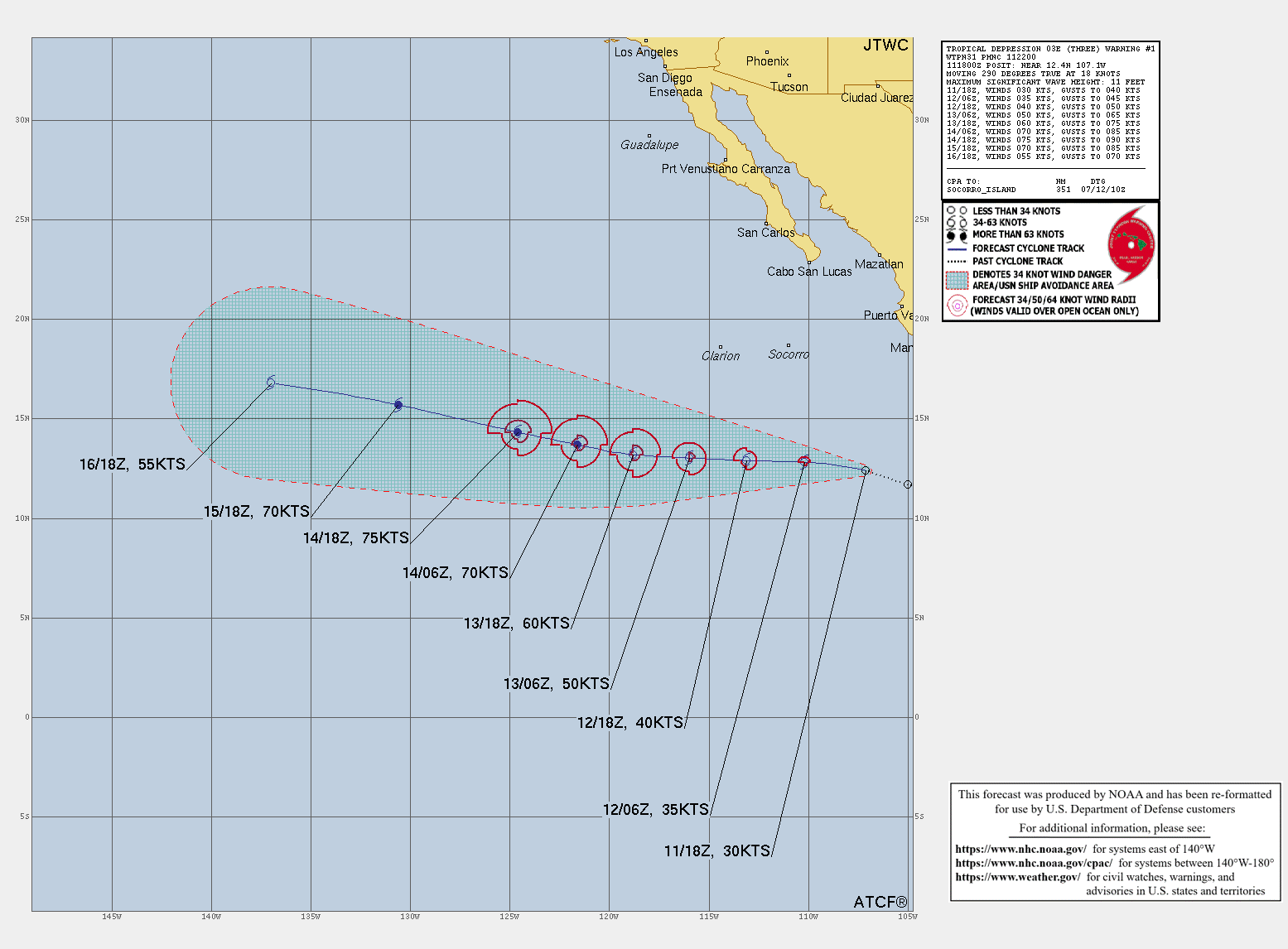
FORECAST POSITIONS AND MAX WINDS
INIT 11/2100Z 12.5N 107.9W 30 KT 35 MPH
12H 12/0600Z 12.8N 110.2W 35 KT 40 MPH
24H 12/1800Z 12.9N 113.1W 40 KT 45 MPH
36H 13/0600Z 13.0N 116.0W 50 KT 60 MPH
48H 13/1800Z 13.2N 118.8W 60 KT 70 MPH
60H 14/0600Z 13.7N 121.6W 70 KT 80 MPH
72H 14/1800Z 14.3N 124.6W 75 KT 85 MPH
96H 15/1800Z 15.7N 130.6W 70 KT 80 MPH
120H 16/1800Z 16.8N 137.0W 55 KT 65 MPH
$$
Forecaster Kelly/Cangialosi
000
WTPZ43 KNHC 120837
TCDEP3
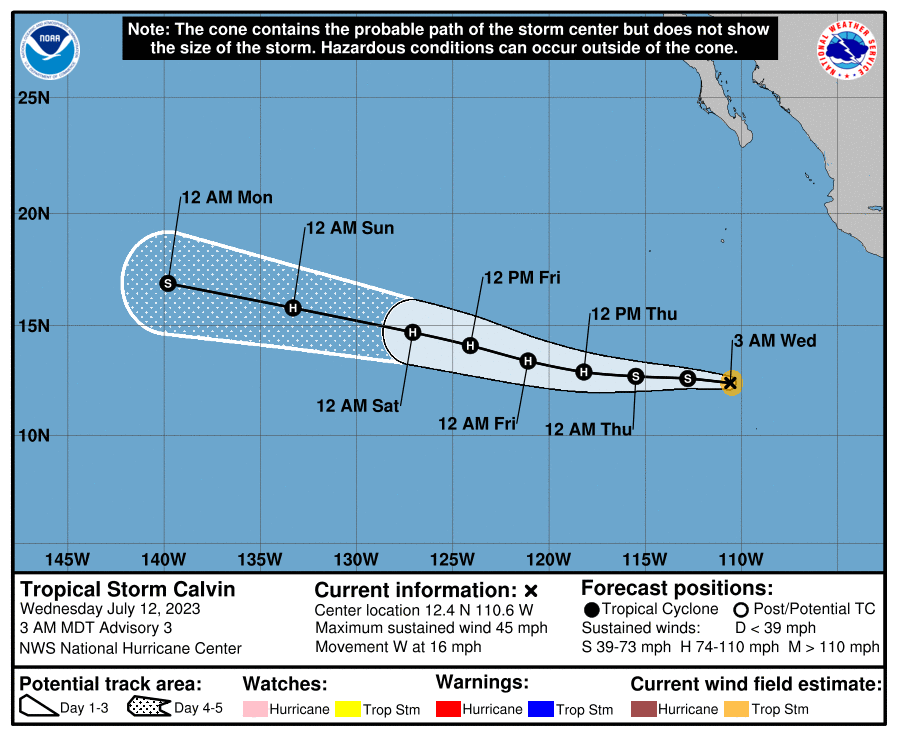
Tropical Storm Calvin Discussion Number 3
NWS National Hurricane Center Miami FL EP032023
300 AM MDT Wed Jul 12 2023
Deep convection associated with the cyclone has continued to become
better organized overnight. There has been a noticeable increase
in banding and the center appears to be located beneath a
developing CDO. Data T-numbers from TAFB and SAB were 2.5 and
3.0, respectively although the final T-number from SAB was lower.
A couple of scatterometer passes shortly before 0600 UTC revealed
winds of 32-34 kt. Based on the continued improvement in
structure since that time and the Dvorak data-T numbers, the
initial intensity is raised to 40 kt for this advisory. Calvin
becomes the third named storm of the 2023 eastern Pacific hurricane
season.
Environmental conditions consisting of light-to-moderate shear,
warm sea surface temperatures, and plentiful low- to mid-level
moisture favor continued intensification of the system during the
next couple of days. Given the fairly small radius of maximum
wind (RMW) noted in the recent scatterometer data and the conducive
environment, steady strengthening is predicted, and Calvin is now
forecast to become a hurricane within 36 hours. It would not be
surprising to see the storm go through a period of rapid
strengthening, however the model guidance is not very bullish on
that scenario. The NHC intensity forecast is near the upper-end of
the guidance, but this could be somewhat conservative. By 72 hours,
Calvin is expected to encounter cooler sea surface temperatures
which is likely to induce gradual weakening during the
remainder of the period.
Calvin is moving westward or 270/14 kt. A strong low- to mid-level
ridge located to the north of Calvin should steer the cyclone
westward during the next several days. After that time, Calvin is
forecast to move westward to west-northwestward to the south of the
ridge. Although the guidance is in good agreement on that overall
scenario, there are some differences in the predicted forward speed
of the cyclone. The updated NHC track forecast lies near the center
of the guidance envelope, close to the various consensus aids to
account for those speed differences.
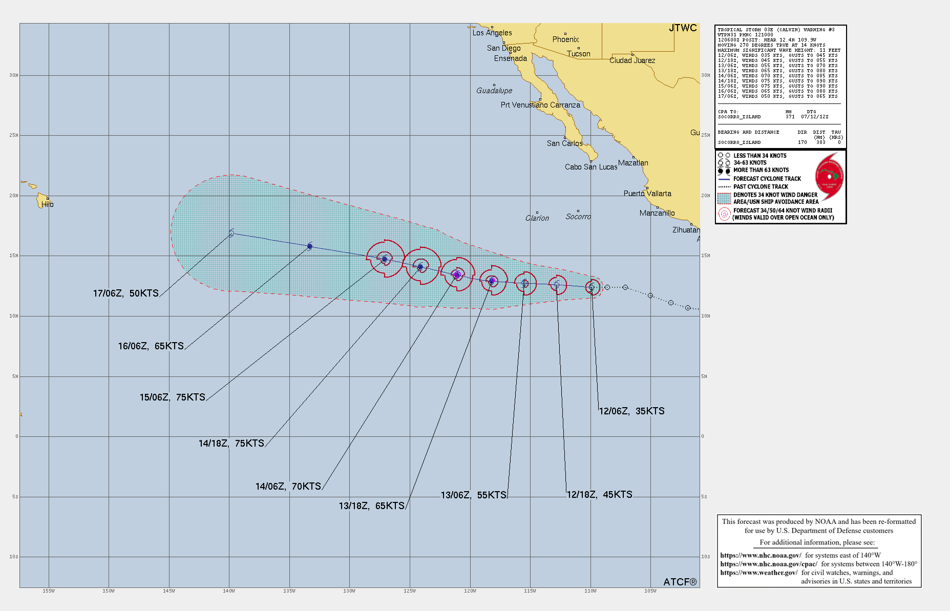
FORECAST POSITIONS AND MAX WINDS
INIT 12/0900Z 12.4N 110.6W 40 KT 45 MPH
12H 12/1800Z 12.6N 112.8W 45 KT 50 MPH
24H 13/0600Z 12.7N 115.5W 55 KT 65 MPH
36H 13/1800Z 12.9N 118.2W 65 KT 75 MPH
48H 14/0600Z 13.4N 121.1W 70 KT 80 MPH
60H 14/1800Z 14.1N 124.1W 75 KT 85 MPH
72H 15/0600Z 14.7N 127.1W 75 KT 85 MPH
96H 16/0600Z 15.8N 133.3W 65 KT 75 MPH
120H 17/0600Z 16.9N 139.8W 50 KT 60 MPH
$$
Forecaster Brown
|
|