開啟輔助訪問
 找回密碼
 立即加入

04L.Debby 高緯轉化為熱帶風暴 持續北上

查看數: 8737 評論數: 5 收藏 0切换到帖子模式
    組圖打開中,請稍候......
發佈時間: 2018-8-4 13:46

正文摘要:

本帖最後由 霧峰追風者 於 2018-9-26 03:45 編輯   熱帶風暴   編號:04 L 名稱:Debby 以上資料來自:NHC、颱風論壇整理製作

Meow 發表於 2018-8-7 23:09
直接編副熱帶風暴,命名Debby。
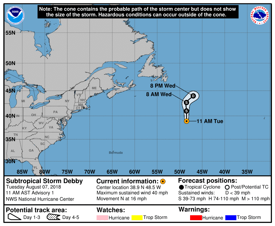
145631_5day_cone_with_line_and_wind.png

899
WTNT44 KNHC 071455
TCDAT4

Subtropical Storm Debby Discussion Number   1
NWS National Hurricane Center Miami FL       AL042018
1100 AM AST Tue Aug 07 2018

The non-tropical low that NHC has been tracking over the North
Atlantic for the past few days has developed subtropical
characteristics and has been upgraded to subtropical storm status.
The tropical-storm-force winds associated with Debby are well
removed from the center as indicated by a recent ASCAT pass and are
occurring within a cyclonically curved band of moderate convection.
Although transition to a tropical cyclone is possible, no
significant strengthening is anticipated since the cyclone will soon
be moving over cool water and become fully embedded within a larger
mid-latitude trough approaching from the west. Debby is expected to
dissipate in about 48 hours or earlier.

The best estimate of the initial motion is toward the north or 355
degrees at 14 kt. The subtropical storm should continue on this
general track with a decrease in forward speed for the next 24
hours or so and then turn to the northeast ahead of the trough,
which will eventually absorb Debby.

FORECAST POSITIONS AND MAX WINDS

INIT  07/1500Z 38.9N  48.5W   35 KT  40 MPH
12H  08/0000Z 41.0N  48.5W   35 KT  40 MPH
24H  08/1200Z 42.7N  48.5W   35 KT  40 MPH
36H  09/0000Z 44.0N  47.0W   30 KT  35 MPH
48H  09/1200Z...DISSIPATED

$$
Forecaster Avila
t02436 發表於 2018-8-7 23:09
NHC直接命名Debby,只不過是副熱帶風暴。
899
WTNT44 KNHC 071455
TCDAT4

Subtropical Storm Debby Discussion Number   1
NWS National Hurricane Center Miami FL       AL042018
1100 AM AST Tue Aug 07 2018

The non-tropical low that NHC has been tracking over the North
Atlantic for the past few days has developed subtropical
characteristics and has been upgraded to subtropical storm status.
The tropical-storm-force winds associated with Debby are well
removed from the center as indicated by a recent ASCAT pass and are
occurring within a cyclonically curved band of moderate convection.
Although transition to a tropical cyclone is possible, no
significant strengthening is anticipated since the cyclone will soon
be moving over cool water and become fully embedded within a larger
mid-latitude trough approaching from the west. Debby is expected to
dissipate in about 48 hours or earlier.

The best estimate of the initial motion is toward the north or 355
degrees at 14 kt. The subtropical storm should continue on this
general track with a decrease in forward speed for the next 24
hours or so and then turn to the northeast ahead of the trough,
which will eventually absorb Debby.

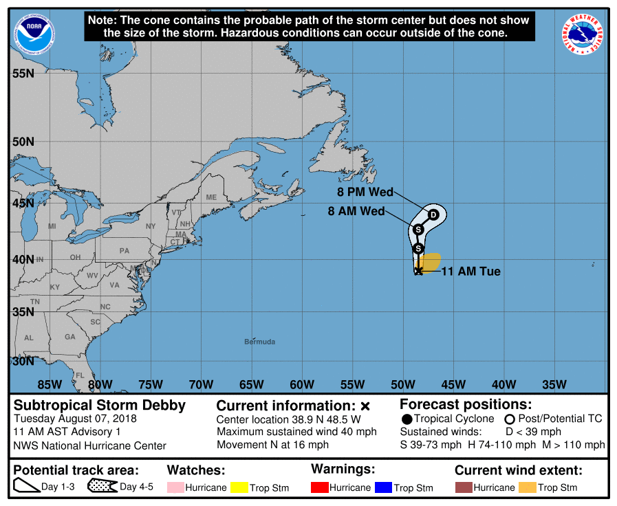
FORECAST POSITIONS AND MAX WINDS

INIT  07/1500Z 38.9N  48.5W   35 KT  40 MPH
12H  08/0000Z 41.0N  48.5W   35 KT  40 MPH
24H  08/1200Z 42.7N  48.5W   35 KT  40 MPH
36H  09/0000Z 44.0N  47.0W   30 KT  35 MPH
48H  09/1200Z...DISSIPATED

$$
Forecaster Avila

145631_5day_cone_with_line.png

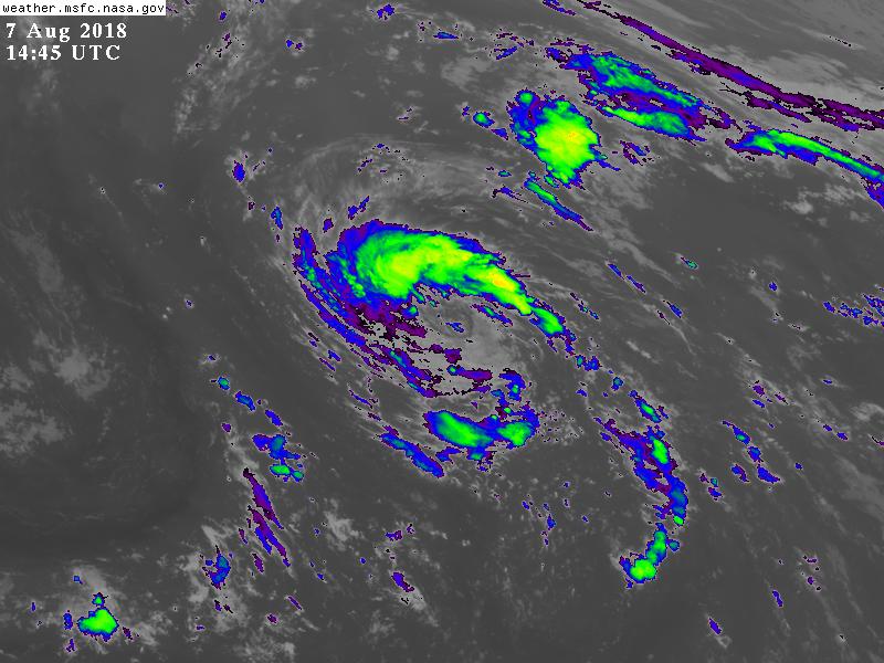
GOES144520182197Jnt6a.jpg

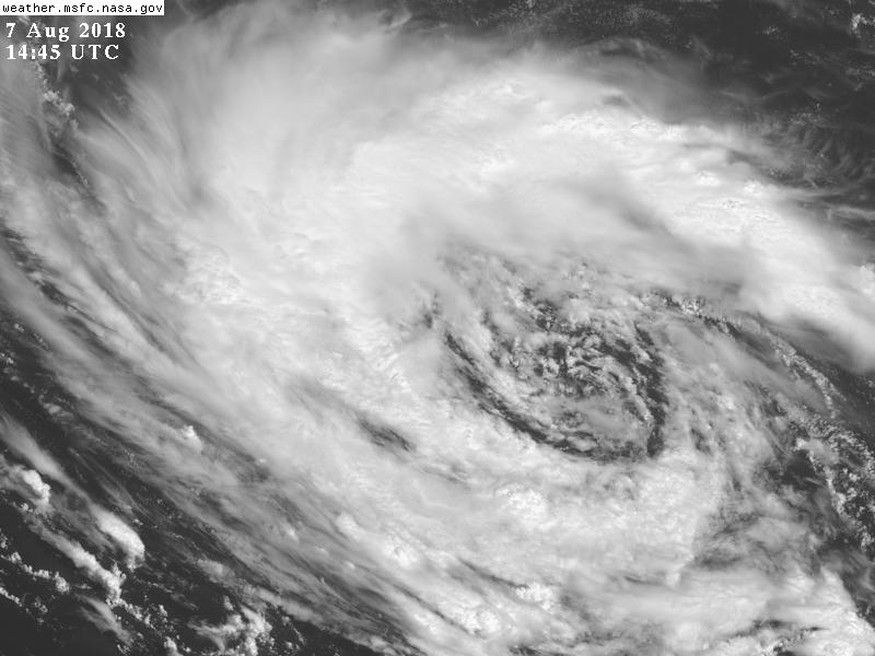
GOES14452018219rYRsMR.jpg
周子堯@FB 發表於 2018-8-7 17:29
NHC評級升到50%(Medium)

1. Satellite data indicate that thunderstorm activity during the past
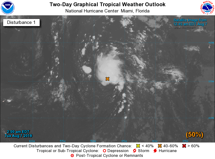
several hours has increased and become better organized in
association with a well-defined, non-tropical low pressure system
centered about 950 miles west-southwest of the Azores. Environmental
conditions are expected to be somewhat conducive for the system to
acquire subtropical or tropical characteristics later today. By
Wednesday, however, the low will encounter increasingly cooler
waters, which will hinder development while the system moves toward
the north-northeast over the open North Atlantic.  Additional
information on this system can be found in High Seas Forecasts
issued by the National Weather Service.
* Formation chance through 48 hours...medium...50 percent.
* Formation chance through 5 days...medium...50 percent.
two_atl_2d1.png


本平台僅供學術討論之用,預報應以氣象局為準

威普網站虛擬主機贊助公司

臺灣第一個天氣類型社群平台 即時天氣資訊、精準颱風動態

線上客服
FB傳送訊息
廣告行銷
精準行銷 物超所值
官方粉專
發佈 快速回復 返回頂部 返回列表