開啟輔助訪問
 找回密碼
 立即加入

04L.Debby 高緯轉化為熱帶風暴 持續北上

簽到天數: 601 天

[LV.9]以壇為家II

2018-8-4 13:46 | 顯示全部樓層
本帖最後由 霧峰追風者 於 2018-9-26 03:45 編輯

  熱帶風暴  
編號:04 L
名稱:Debby
800px-Debby_2018-08-08_1430Z.jpg
  基本資料  
擾動編號日期:2018 08 04 13
命名日期  :2018 08 07 23
撤編日期  :2018 08 10 05
登陸地點  :

  巔峰時期資料  
近中心最強風速
國家颶風中心(NHC):40 kts
海平面最低氣壓1002 百帕

  過去路徑圖  
1920px-Debby_2018_track.png
  擾動編號資料  

97L.INVEST.35kts-1008mb-38.9N-42.1W

20180804.0500.msg-4.ir.97L.INVEST.35kts.1010mb.38.9N.42.1W.100pc.jpg
  NHC:10%  
1. A non-tropical low pressure system located about 700 miles west
of the Azores is producing gale-force wind gusts northeast of its
center. Although associated shower activity is currently limited,
the low could gradually acquire subtropical or tropical
characteristics over the next few days while it moves southwestward
over warmer water. Additional information on this low pressure area
can be found in High Seas Forecasts issued by the National Weather
Service.
* Formation chance through 48 hours...low...10 percent.
* Formation chance through 5 days...low...20 percent.

two_atl_2d1.png
以上資料來自:NHC颱風論壇整理製作

評分

參與人數 1水氣能量 +15 +1 收起 理由
t02436 + 15 + 1

查看全部評分

回復

使用道具 舉報

簽到天數: 2141 天

[LV.Master]伴壇終老

周子堯@FB|2018-8-7 17:29 | 顯示全部樓層
NHC評級升到50%(Medium)

1. Satellite data indicate that thunderstorm activity during the past
several hours has increased and become better organized in
association with a well-defined, non-tropical low pressure system
centered about 950 miles west-southwest of the Azores. Environmental
conditions are expected to be somewhat conducive for the system to
acquire subtropical or tropical characteristics later today. By
Wednesday, however, the low will encounter increasingly cooler
waters, which will hinder development while the system moves toward
the north-northeast over the open North Atlantic.  Additional
information on this system can be found in High Seas Forecasts
issued by the National Weather Service.
* Formation chance through 48 hours...medium...50 percent.
* Formation chance through 5 days...medium...50 percent.
two_atl_2d1.png


回復

使用道具 舉報

簽到天數: 3291 天

[LV.Master]伴壇終老

t02436|2018-8-7 23:09 | 顯示全部樓層
NHC直接命名Debby,只不過是副熱帶風暴。
899
WTNT44 KNHC 071455
TCDAT4

Subtropical Storm Debby Discussion Number   1
NWS National Hurricane Center Miami FL       AL042018
1100 AM AST Tue Aug 07 2018

The non-tropical low that NHC has been tracking over the North
Atlantic for the past few days has developed subtropical
characteristics and has been upgraded to subtropical storm status.
The tropical-storm-force winds associated with Debby are well
removed from the center as indicated by a recent ASCAT pass and are
occurring within a cyclonically curved band of moderate convection.
Although transition to a tropical cyclone is possible, no
significant strengthening is anticipated since the cyclone will soon
be moving over cool water and become fully embedded within a larger
mid-latitude trough approaching from the west. Debby is expected to
dissipate in about 48 hours or earlier.

The best estimate of the initial motion is toward the north or 355
degrees at 14 kt. The subtropical storm should continue on this
general track with a decrease in forward speed for the next 24
hours or so and then turn to the northeast ahead of the trough,
which will eventually absorb Debby.

FORECAST POSITIONS AND MAX WINDS

INIT  07/1500Z 38.9N  48.5W   35 KT  40 MPH
12H  08/0000Z 41.0N  48.5W   35 KT  40 MPH
24H  08/1200Z 42.7N  48.5W   35 KT  40 MPH
36H  09/0000Z 44.0N  47.0W   30 KT  35 MPH
48H  09/1200Z...DISSIPATED

$$
Forecaster Avila

145631_5day_cone_with_line.png

GOES144520182197Jnt6a.jpg

GOES14452018219rYRsMR.jpg
回復

使用道具 舉報

簽到天數: 588 天

[LV.9]以壇為家II

Meow|2018-8-7 23:09 | 顯示全部樓層
直接編副熱帶風暴,命名Debby。
145631_5day_cone_with_line_and_wind.png

899
WTNT44 KNHC 071455
TCDAT4

Subtropical Storm Debby Discussion Number   1
NWS National Hurricane Center Miami FL       AL042018
1100 AM AST Tue Aug 07 2018

The non-tropical low that NHC has been tracking over the North
Atlantic for the past few days has developed subtropical
characteristics and has been upgraded to subtropical storm status.
The tropical-storm-force winds associated with Debby are well
removed from the center as indicated by a recent ASCAT pass and are
occurring within a cyclonically curved band of moderate convection.
Although transition to a tropical cyclone is possible, no
significant strengthening is anticipated since the cyclone will soon
be moving over cool water and become fully embedded within a larger
mid-latitude trough approaching from the west. Debby is expected to
dissipate in about 48 hours or earlier.

The best estimate of the initial motion is toward the north or 355
degrees at 14 kt. The subtropical storm should continue on this
general track with a decrease in forward speed for the next 24
hours or so and then turn to the northeast ahead of the trough,
which will eventually absorb Debby.

FORECAST POSITIONS AND MAX WINDS

INIT  07/1500Z 38.9N  48.5W   35 KT  40 MPH
12H  08/0000Z 41.0N  48.5W   35 KT  40 MPH
24H  08/1200Z 42.7N  48.5W   35 KT  40 MPH
36H  09/0000Z 44.0N  47.0W   30 KT  35 MPH
48H  09/1200Z...DISSIPATED

$$
Forecaster Avila
回復

使用道具 舉報

簽到天數: 601 天

[LV.9]以壇為家II

霧峰追風者|2018-8-7 23:09 | 顯示全部樓層
本帖最後由 霧峰追風者 於 2018-8-8 02:43 編輯

NHC 命名"Debby",判定為副熱帶風暴。
899
WTNT44 KNHC 071455
TCDAT4

Subtropical Storm Debby Discussion Number   1
NWS National Hurricane Center Miami FL       AL042018
1100 AM AST Tue Aug 07 2018

The non-tropical low that NHC has been tracking over the North
Atlantic for the past few days has developed subtropical
characteristics and has been upgraded to subtropical storm status.
The tropical-storm-force winds associated with Debby are well
removed from the center as indicated by a recent ASCAT pass and are
occurring within a cyclonically curved band of moderate convection.
Although transition to a tropical cyclone is possible, no
significant strengthening is anticipated since the cyclone will soon
be moving over cool water and become fully embedded within a larger
mid-latitude trough approaching from the west. Debby is expected to
dissipate in about 48 hours or earlier.

The best estimate of the initial motion is toward the north or 355
degrees at 14 kt. The subtropical storm should continue on this
general track with a decrease in forward speed for the next 24
hours or so and then turn to the northeast ahead of the trough,
which will eventually absorb Debby.

FORECAST POSITIONS AND MAX WINDS

INIT  07/1500Z 38.9N  48.5W   35 KT  40 MPH
12H  08/0000Z 41.0N  48.5W   35 KT  40 MPH
24H  08/1200Z 42.7N  48.5W   35 KT  40 MPH
36H  09/0000Z 44.0N  47.0W   30 KT  35 MPH
48H  09/1200Z...DISSIPATED

$$
Forecaster Avila
145631_5day_cone_no_line_and_wind.png 20180807.1400.msg-4.ircolor.97L.INVEST.30kts.1010mb.38.2N.48.2W.100pc.jpg 20180807.1640.f15.vis.olsviscomp.04L.DEBBY.x.jpg

回復

使用道具 舉報

簽到天數: 601 天

[LV.9]以壇為家II

霧峰追風者|2018-8-8 21:48 | 顯示全部樓層
本帖最後由 霧峰追風者 於 2018-8-8 21:49 編輯

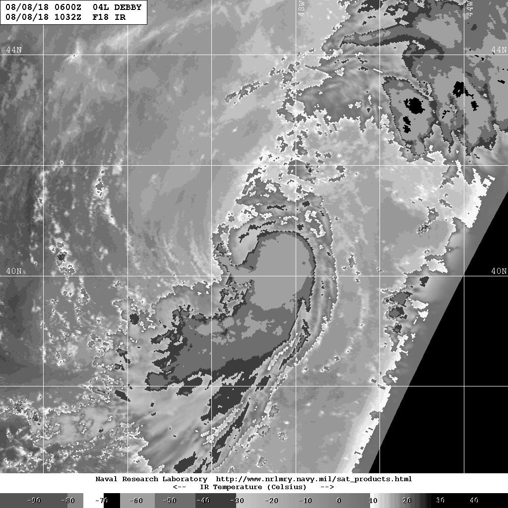
NHC 判定轉化成熱帶風暴,緯度超過40N,持續北上。
588
WTNT44 KNHC 080834
TCDAT4

Tropical Storm Debby Discussion Number   4
NWS National Hurricane Center Miami FL       AL042018
500 AM AST Wed Aug 08 2018

Over the past several hours, deep convection with cloud tops of -55
to -60 deg C has developed in the southeastern semicircle, with
some of the convective tops covering the previously exposed
low-level circulation center. In addition, outer banding
features have dissipated, and an elongated upper-level anticyclone
has developed over the cyclone. These convective- and synoptic-scale
features indicate that Debby has made the transition from a
subtropical to a tropical cyclone. The initial intensity of 40 kt
is based on a blend of UW-CIMSS ADT and SATCON intensity estimates
of 39 kt and 42 kt, respectively. Furthermore, the 34-kt wind radii
and radius of maximum winds (RMW) were decreased significantly on
this advisory based on ASCAT wind data.

The initial motion estimate is now 015/08 kt.  Debby has made the
forecast turn toward the north-northeast, and a further turn toward
the northeast is expected later today as the cyclone moves around
the northwestern periphery of a deep-layer ridge and ahead of an
approaching mid-level trough. The latest model guidance remains in
good agreement on this developing track scenario, and the new NHC
forecast track is similar to the previous advisory, and lies close
to a blend of the track consensus models HCCA and FSSE.

Debby will be moving along a tight sea-surface temperature (SST)
gradient for the next 24-36 hours or so, with the northwestern half
the circulation being over sub-25C SSTs and the southeastern
semicircle being over warmer waters where convection could continue
to develop. Given the relatively low vertical wind shear regime
that the cyclone will be moving through, along with the possibility
of deep convection persisting near the center, the intensity
forecast calls for little change in strength today, followed by
only slight weakening tonight and early Thursday. By Thursday night
or early Friday, SSTs beneath the cyclone are expected to decrease
to near 20 deg C and the shear is forecast to increase to more than
20 kt, an unfavorable combination that should result in Debby
dissipating over the far north Atlantic by 48 hours.

FORECAST POSITIONS AND MAX WINDS

INIT  08/0900Z 40.8N  48.8W   40 KT  45 MPH
12H  08/1800Z 41.8N  48.2W   40 KT  45 MPH
24H  09/0600Z 43.2N  46.1W   35 KT  40 MPH
36H  09/1800Z 44.5N  43.4W   30 KT  35 MPH
48H  10/0600Z...DISSIPATED

$$
Forecaster Stewart
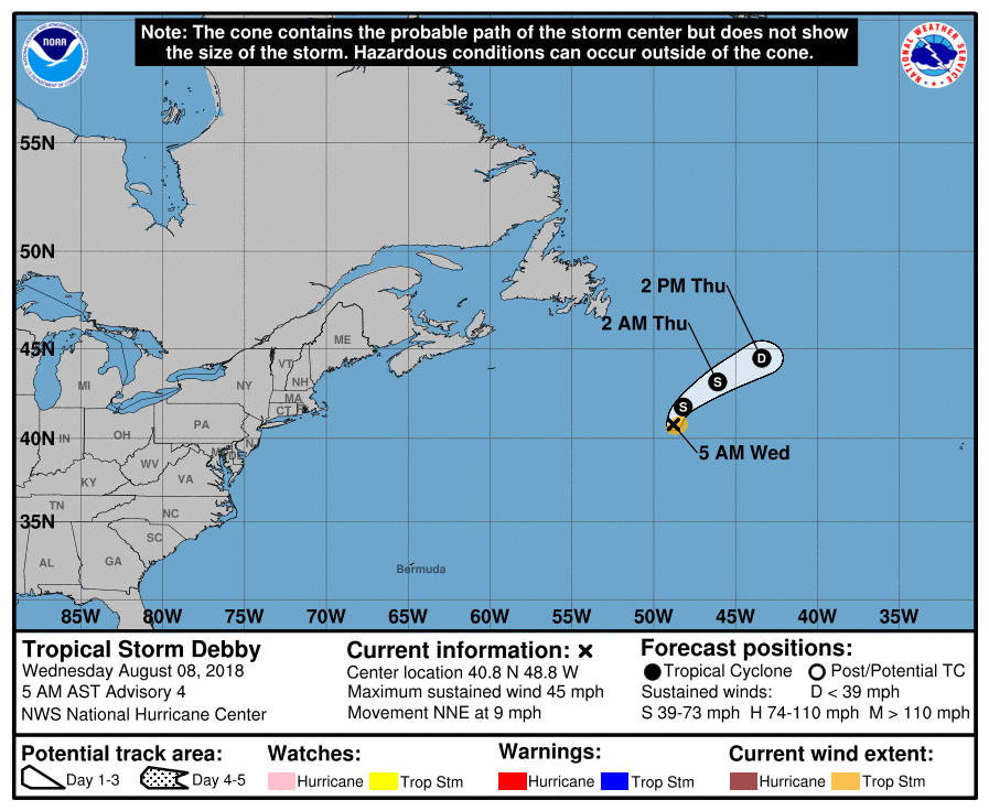
083443_5day_cone_no_line_and_wind.png 20180808.1032.f18.ir.BD.04LDEBBY.40kts-1003mb.jpg

回復

使用道具 舉報

快速回覆
您需要登錄後才可以回帖 登錄 | 立即加入

本版積分規則

霧峰追風者

    主題

    帖子

    221萬

    積分

    16級[四級颶風]

    Rank: 16Rank: 16Rank: 16Rank: 16

16級[四級颶風]

發訊息

本平台僅供學術討論之用,預報應以氣象局為準

威普網站虛擬主機贊助公司

臺灣第一個天氣類型社群平台 即時天氣資訊、精準颱風動態

線上客服
FB傳送訊息
廣告行銷
精準行銷 物超所值
官方粉專
發佈 快速回復 返回頂部 返回列表