|
|
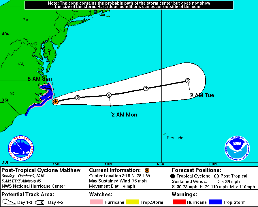
已經是後熱帶氣旋,但威力依舊。

000
WTNT44 KNHC 090855
TCDAT4
POST-TROPICAL CYCLONE MATTHEW DISCUSSION NUMBER 45
NWS NATIONAL HURRICANE CENTER MIAMI FL AL142016
500 AM EDT SUN OCT 09 2016
Satellite and radar imagery indicate that Matthew has become a
post-tropical cyclone, with the closest deep convection now located
more than 150 nmi north and northeast of the exposed low-level
center. Despite this change in structure, surface observations
across eastern North Carolina and an earlier ASCAT pass indicate
that strong winds persist northwest through southwest of the
center. An Air Force Reserve reconnaissance mission completed
earlier this morning also indicated that hurricane-force winds
were occuring southwest of the center, so the initial intensity
is being maintained at 65 kt for this advisory. Surface
observations indicate that a cold front should overtake Matthew's
center shortly, resulting in extratropical transition. The global
and regional models forecast Matthew to slowly weaken over the next
48 hours, and that trend has been followed in the official
intensity forecast. In the 48-72 hour time period, Matthew's
circulation is expected to dissipate within the frontal system.
A combination of satellite and radar imagery, aircraft data, and
coastal surface observations indicate that Matthew is moving 065/12
kt. Matthew is now fully embedded within the mid-latitude westerly
flow, and this deep-layer steering pattern is expected to move the
cyclone east-northeastward and away from the coast of North
Carolina today. An eastward motion is expected by tonight and
should continue until Matthew dissipates in 48 hours or so. The new
NHC track forecast is a little north of the previous track and lies
close to a blend of the ECMWF, UKMET, and GFS solutions.
Recent observations and the forecast strength of the band of winds
over the eastern North Carolina coastal area requires maintaining
the Hurricane Watch. Strong winds in the Tidewater Region of
Virginia are being handled by non-tropical wind warnings.
KEY MESSAGES:
1. As Matthew's structure changes, the system's strongest winds
continue to shift to the west side of the circulation. The winds
are expected to increase significantly over the coastal areas of
eastern North Carolina during the next several hours, and during
the next 6 to 12 hours there is the possibility of near-hurricane
force winds over the North Carolina Outer Banks, as well as the
Pamlico and Albemarle Sounds. There is also an increased threat of
storm surge in these areas. Please see the Prototype Storm Surge
Watch/Warning Graphic for a depiction of the areas at risk.
2. Although Matthew has become a post-tropical cyclone, NHC will
continue to issue its full suite of advisory and warning products
as long as the system remains a significant threat to land areas.
FORECAST POSITIONS AND MAX WINDS
INIT 09/0900Z 34.9N 75.1W 65 KT 75 MPH...POST-TROPICAL
12H 09/1800Z 35.2N 73.0W 60 KT 70 MPH...POST-TROP/EXTRATROP
24H 10/0600Z 35.4N 70.0W 50 KT 60 MPH...POST-TROP/EXTRATROP
36H 10/1800Z 35.9N 66.5W 40 KT 45 MPH...POST-TROP/EXTRATROP
48H 11/0600Z 36.5N 62.5W 35 KT 40 MPH...POST-TROP/EXTRATROP
72H 12/0600Z...DISSIPATED
$$
Forecaster Stewart |
|