開啟輔助訪問
 找回密碼
 立即加入

06L.Emily 登陸前火速命名 橫越佛州加速北上

簽到天數: 498 天

[LV.9]以壇為家II

2017-7-31 01:20 | 顯示全部樓層
  熱帶風暴  
編號:06 L
名稱:Emily

  基本資料  
擾動編號日期:2017 07 31 01
命名日期  :2017 07 31 20
撤編日期  :2017 08 03 20
登陸地點  :美國 佛羅里達州 安娜瑪麗亞島

  巔峰時期資料  
近中心最強風速
國家颶風中心(NHC):40 kts
海平面最低氣壓 :1006 百帕

  過去路徑圖  
06L-Emily.png
  擾動編號資料  
98L.INVEST.25kts-1010mb-28.5N-86.5W

20170730.1715.goes13.x.vis1km.98LINVEST.25kts-1010mb-285N-865W.100pc.jpg


NHC:10%
2. An area of low pressure is forecast to develop along a dissipating
frontal boundary over the northeastern Gulf of Mexico during the
next day or so, and then move eastward across the Florida peninsula
into the western Atlantic by midweek.  Any development should be
slow to occur due to only marginally conducive upper-level winds and
proximity to land. However, this system is expected to produce
locally heavy rainfall across portions of central and northeastern
Florida during the next couple of days.  Please see additional
information from your local National Weather Service Forecast
Offices concerning the rainfall threat.
* Formation chance through 48 hours...low...10 percent.
* Formation chance through 5 days...low...20 percent.

two_atl_2d2.png

以上資料來自:NHC、颱風論壇整理製作

評分

參與人數 1水氣能量 +15 收起 理由
king111807 + 15

查看全部評分

回復

使用道具 舉報

簽到天數: 82 天

[LV.6]常住居民II

歐詠儀|2017-7-31 19:07 | 顯示全部樓層
NHC 升格06L,不看好命名。
000
WTNT41 KNHC 310954
TCDAT1

Tropical Depression Six Special Discussion Number   1
NWS National Hurricane Center Miami FL       AL062017
600 AM EDT Mon Jul 31 2017

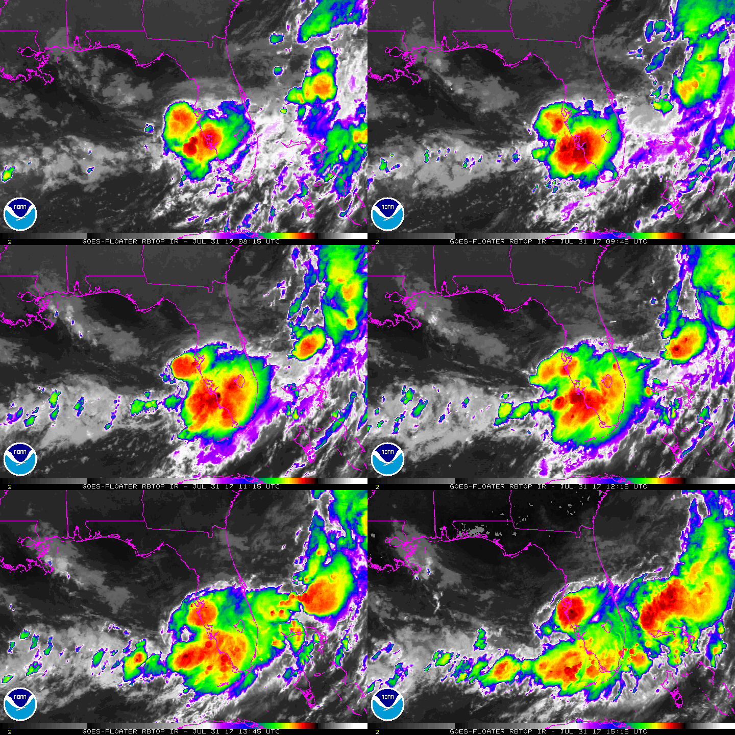
Radar imagery from the NWS Tampa Bay WSR-88D indicates that shower
and thunderstorm activity associated with the small low pressure
area over the eastern Gulf of Mexico have persisted and become
better organized overnight.  Earlier ASCAT data showed that the
system has a well-defined circulation and winds of at least 30 kt
over a small area to the north and northwest of the center. Based on
these data, advisories are being initiated on a 30-kt tropical
depression.  The depression is currently embedded within an area of
moderate to strong northwesterly shear.  Although the upper-level
winds could become a little more favorable for strengthening, the
depression is expected to move inland over the west-central Florida
peninsula later today, and no significant change in wind speed is
predicted.  After the depression moves over the western Atlantic,
increasing westerly shear is forecast to prevent intensification.
This scenario is in agreement with the GFS and ECMWF models, which
show the system weakening and likely dissipating in 3 to 4 days, or
perhaps sooner.

The depression is moving eastward at about 7 kt. The cyclone is
embedded within the southern portion of a deep-layer trough that
extends southwestward along the U.S. east coast. This pattern should
steer the system eastward today, then northeastward with some
increase in forward speed through dissipation. The track guidance is
in relatively good agreement on this scenario, although there are
some differences in how fast the system will accelerate
northeastward. For now, the NHC forecast lies between the faster
HWRF and GFS solutions, and the slower ECMWF.

The primary threat with this system is expected to be locally heavy
rainfall across portions of the Florida peninsula during the next
couple of days. Due to the uncertainty in the intensity forecast, a
Tropical Storm Watch has been issued for a portion of the west-
central coast of Florida.

FORECAST POSITIONS AND MAX WINDS

INIT  31/1000Z 27.7N  83.5W   30 KT  35 MPH
12H  31/1800Z 27.7N  82.4W   30 KT  35 MPH
24H  01/0600Z 28.3N  80.6W   30 KT  35 MPH
36H  01/1800Z 29.8N  78.6W   30 KT  35 MPH
48H  02/0600Z 31.6N  76.5W   30 KT  35 MPH
72H  03/0600Z 34.5N  72.0W   30 KT  35 MPH
96H  04/0600Z...DISSIPATED

$$
Forecaster Brown

095418_5day_cone_no_line_and_wind.png

回復

使用道具 舉報

簽到天數: 588 天

[LV.9]以壇為家II

Meow|2017-7-31 19:54 | 顯示全部樓層
突然就命名了。
114303_5day_cone_with_line_and_wind.png
BULLETIN
Tropical Storm Emily Special Advisory Number   2
NWS National Hurricane Center Miami FL       AL062017
800 AM EDT Mon Jul 31 2017

...DEPRESSION BECOMES A TROPICAL STORM WEST OF TAMPA BAY...
...TROPICAL STORM WARNING ISSUED FOR WEST-CENTRAL FLORIDA...


SUMMARY OF 800 AM EDT...1200 UTC...INFORMATION
----------------------------------------------
LOCATION...27.7N 83.2W
ABOUT 45 MI...75 KM WSW OF TAMPA FLORIDA
ABOUT 50 MI...80 KM WNW OF SARASOTA FLORIDA
MAXIMUM SUSTAINED WINDS...45 MPH...75 KM/H
PRESENT MOVEMENT...E OR 95 DEGREES AT 8 MPH...13 KM/H
MINIMUM CENTRAL PRESSURE...1006 MB...29.71 INCHES
回復

使用道具 舉報

簽到天數: 3279 天

[LV.Master]伴壇終老

t02436|2017-8-1 00:04 | 顯示全部樓層
1445Z自安娜瑪麗亞島登陸。
000
WTNT61 KNHC 311510
TCUAT1

Tropical Storm Emily Tropical Cyclone Update
NWS National Hurricane Center Miami FL       AL062017
1110 AM EDT Mon Jul 31 2017

...TROPICAL STORM EMILY MAKES LANDFALL ON ANNA MARIA ISLAND...

NOAA Doppler weather radar data and surface observations indicate
that Tropical Storm Emily made landfall at 1045 AM EDT (1445 UTC)
on Anna Maria Island, just west of Bradenton, Florida.

SUMMARY OF 1100 AM EDT...1500 UTC...INFORMATION
----------------------------------------------
LOCATION...27.5N 82.7W
ABOUT 10 MI...20 KM NW OF BRADENTON FLORIDA
ABOUT 20 MI...35 KM S OF ST. PETERSBURG FLORIDA
MAXIMUM SUSTAINED WINDS...45 MPH...75 KM/H
PRESENT MOVEMENT...E OR 90 DEGREES AT 9 MPH...15 KM/H
MINIMUM CENTRAL PRESSURE...1005 MB...29.68 INCHES

$$
Forecaster Stewart
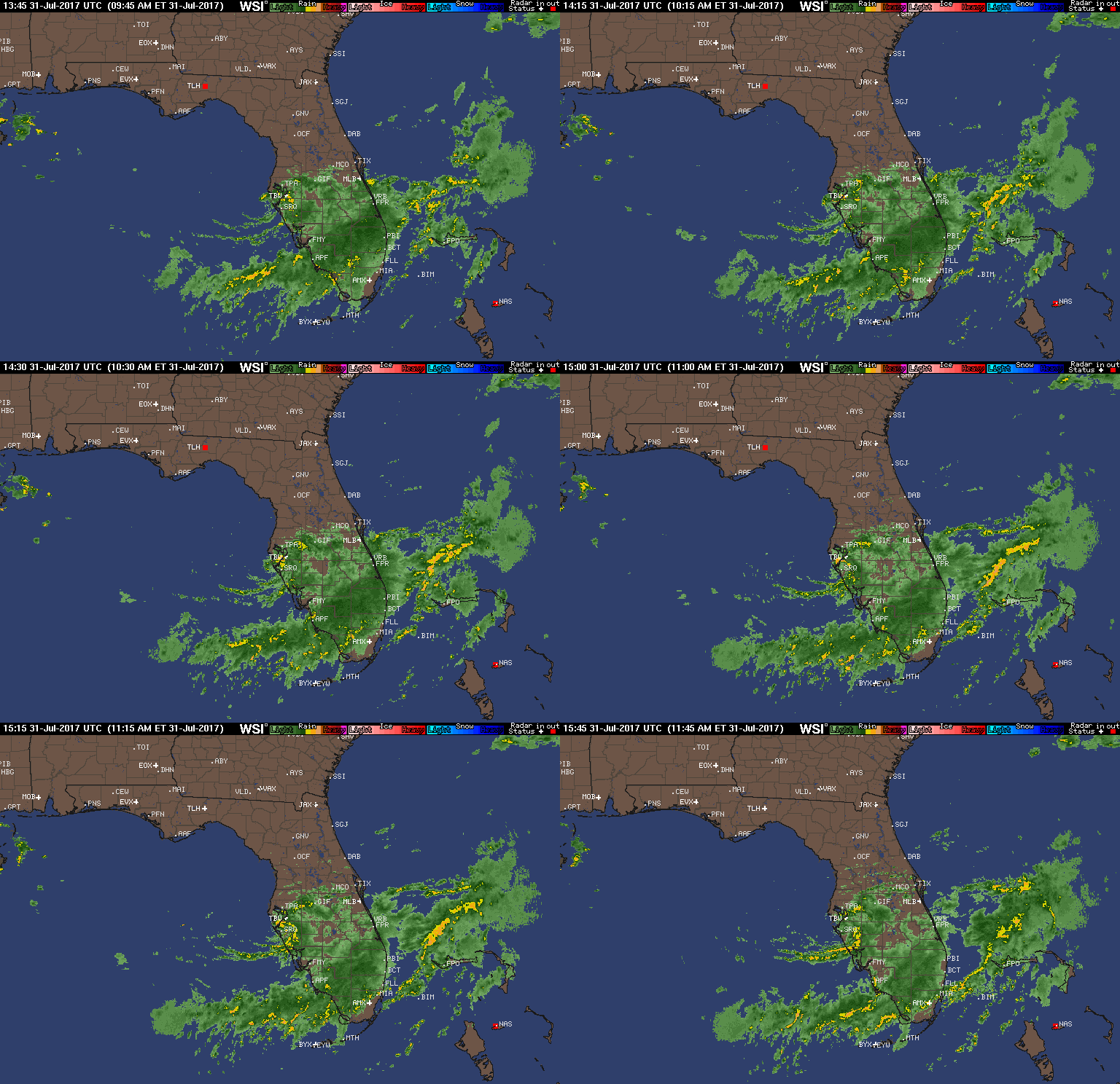
pie_None_anim.gif

000
WTNT41 KNHC 311436
TCDAT1

Tropical Storm Emily Discussion Number   3
NWS National Hurricane Center Miami FL       AL062017
1100 AM EDT Mon Jul 31 2017

There has been little change in Emily's overall structure as seen in
satellite and radar imagery over the past several hours. The
inner-core convection has waxed and waned while the outer convective
bands and rain shield on the south side of the small cyclone have
remained fairly steady. Velocity data from the NOAA Tampa Bay
WSR-88D Doppler radar has been indicating average velocities of
50-52 kt, with isolated bins of 55-62 kt, just south of the
circulation center between 4000-5000 ft altitude during the past few
hours. Using a standard adjustment factor of 80 percent still
supports a surface wind speed estimate of 40 kt.

Little change in strength is forecast until landfall occurs, after
which slow weakening is expected as Emily moves across the Florida
peninsula through tonight. After emerging off of the east-central
Florida on Tuesday, some slow re- strengthening is forecast on days
2-3 when Emily will be moving over SSTs of 28C and the vertical wind
shear will shift from northwesterly to southwesterly and decrease to
10-15 kt. By 96 h, the shear is forecast to increase to 25-30 kt,
which should keep the intensity steady or induce slight weakening
until Emily dissipates in about 120 h. Since Emily is not expected
to regain tropical storm status before it moves offshore of the
Florida east coast Tuesday morning, no watches or warnings are
required for that area.

The initial motion estimate is 090/08 kt. Emily is approaching the
mouth of Tampa Bay, and landfall along the west-central Florida
coast should occur by early afternoon. After landfall, the latest
model guidance remains in excellent agreement on Emily turning
east-northeastward tonight and moving across the central Florida
peninsula as a depression, and emerging off of the east-central
Florida coast Tuesday morning. A mid-/upper-level trough currently
located over the upper Midwest is forecast to dig southeastward and
amplify along the southeastern U.S. coast by 24-36 h, accelerating
Emily to the northeast over the open Atlantic through the remainder
of the forecast period. The new NHC forecast track is just an update
and extension of the previous advisory track, and lies close to the
TVCN consensus model.

The primary threat with Emily is expected to be locally heavy
rainfall across central an southern portions of the Florida
peninsula during the next day or two. However, a brief tornado will
be possible across central and southern Florida today, along with
isolated waterspouts over the coastal waters of southwestern
Florida.

FORECAST POSITIONS AND MAX WINDS

INIT  31/1500Z 27.6N  82.8W   40 KT  45 MPH
12H  01/0000Z 27.7N  81.6W   30 KT  35 MPH...INLAND
24H  01/1200Z 28.9N  79.6W   35 KT  40 MPH...OVER WATER
36H  02/0000Z 30.5N  77.7W   35 KT  40 MPH
48H  02/1200Z 32.2N  75.6W   40 KT  45 MPH
72H  03/1200Z 35.3N  70.8W   40 KT  45 MPH
96H  04/1200Z 37.7N  63.5W   40 KT  45 MPH
120H  05/1200Z...DISSIPATED

$$
Forecaster Stewart
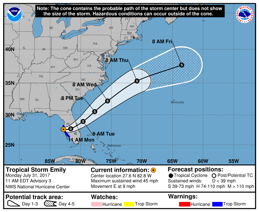
143934_5day_cone_with_line.png

rbtop-animated.gif

回復

使用道具 舉報

簽到天數: 3279 天

[LV.Master]伴壇終老

t02436|2017-8-1 21:21 | 顯示全部樓層
出海了,但不再看好重回熱帶風暴以上強度。
000
WTNT41 KNHC 010835
TCDAT1

Tropical Depression Emily Discussion Number   6
NWS National Hurricane Center Miami FL       AL062017
500 AM EDT Tue Aug 01 2017

Radar and surface observations over east-central Florida indicate
that Emily's circulation has become quite elongated.  Water vapor
imagery also shows that drier mid-level air has moved over the
northwestern portion of the circulation, which has limited the
amount of convection near the center overnight.  Some deep
convection is noted along a trough axis well to the northeast of
Emily. Earlier ASCAT data revealed a few 20-25 kt wind vectors just
off the coast of Florida to the southeast of the center, so the
initial intensity remains 25 kt for this advisory.

Emily has been moving east-northeastward overnight.  The cyclone
remains embedded within the base of a mid-level trough that extends
southwestward just off the southeastern United States coast.  As
this trough lifts out, Emily should accelerate northeastward between
the western Atlantic ridge and another mid-level trough that will
approach the southeast United States in a day or so. The global
models shifted slightly westward this cycle, and the new NHC
track has been nudged in that direction.

The intensity forecast remains quite uncertain.  Since Emily's
circulation has become less defined and is near a weak frontal
zone, it is possible that that system will be absorbed within the
larger trough axis.  For now, the NHC forecast assumes that Emily
will maintain its identity and have a chance to restrengthen over
the western Atlantic.  Although the shear is not forecast to be
prohibitive during the next day or so, the current structure and
nearby dry air suggest any deepening should be slow to occur.  This
is supported by the global models which do not indicate much
intensification.  The NHC forecast is a little below the previous
advisory and is close to guidance provided by the NOAA Ocean
Prediction Center.  Emily is forecast to become extratropical in
about 36 hours, but it could dissipate or become post-tropical
sooner than that.


FORECAST POSITIONS AND MAX WINDS

INIT  01/0900Z 28.3N  80.1W   25 KT  30 MPH
12H  01/1800Z 29.4N  78.6W   25 KT  30 MPH
24H  02/0600Z 31.0N  76.5W   30 KT  35 MPH
36H  02/1800Z 32.8N  73.6W   30 KT  35 MPH...POST-TROP/EXTRATROP
48H  03/0600Z 34.4N  70.4W   30 KT  35 MPH...POST-TROP/EXTRATROP
72H  04/0600Z 37.0N  64.0W   30 KT  35 MPH...POST-TROP/EXTRATROP
96H  05/0600Z 38.5N  57.0W   30 KT  35 MPH...POST-TROP/EXTRATROP
120H  06/0600Z...DISSIPATED

$$
Forecaster Brown

083907_5day_cone_with_line_and_wind.png

rbtop-animated.gif

回復

使用道具 舉報

快速回覆
您需要登錄後才可以回帖 登錄 | 立即加入

本版積分規則

...

    主題

    帖子

    39萬

    積分

    12級[颶風Hurricane]

    Rank: 12Rank: 12Rank: 12

12級[颶風Hurricane]

發訊息

本平台僅供學術討論之用,預報應以氣象局為準

威普網站虛擬主機贊助公司

臺灣第一個天氣類型社群平台 即時天氣資訊、精準颱風動態

線上客服
FB傳送訊息
廣告行銷
精準行銷 物超所值
官方粉專
發佈 快速回復 返回頂部 返回列表