開啟輔助訪問
 找回密碼
 立即加入

08L.Gert 橫越大西洋終命名 高緯開眼爆發增強上C2

簽到天數: 498 天

[LV.9]以壇為家II

2017-8-3 20:51 | 顯示全部樓層
  二級颶風  
編號:08 L
名稱:Gert

  基本資料  
擾動編號日期:2017 08 03 18
命名日期  :2017 08 14 05
撤編日期  :2017 08 19 06
登陸地點  :

  巔峰時期資料  
近中心最強風速
國家颶風中心(NHC):90 kts
海平面最低氣壓 :967 百帕

  過去路徑圖  
08L-Gert.png
  擾動編號資料  
99L.INVEST.20kts.1010mb.10.0N.17.2W

20170803.1145.goes13.x.vis1km_high.99LINVEST.20kts-1010mb-100N-172W.100pc.jpg

NHC:30%
1. A large area of showers and thunderstorms centered about 500 miles
southeast of the Cabo Verde Islands is associated with a vigorous
tropical wave. Environmental conditions are forecast to be conducive
for gradual development, and a tropical depression could form by
early next week over the eastern or central tropical Atlantic
Ocean. This system is forecast to move toward the west or
west-northwest at 10 to 15 mph for the next several days.
* Formation chance through 48 hours...low...30 percent.
* Formation chance through 5 days...medium...60 percent.

two_atl_2d1.png

以上資料來自:NHC、颱風論壇整理製作

評分

參與人數 1水氣能量 +15 收起 理由
king111807 + 15

查看全部評分

回復

使用道具 舉報

簽到天數: 601 天

[LV.9]以壇為家II

霧峰追風者|2017-8-4 19:40 | 顯示全部樓層
NHC 展望提升至40%,機構看好發展。
1. A large and complex area of disturbed weather, associated with a
broad low pressure system, extends from about 400 miles south of
the Cabo Verde Islands to about 600 miles southwest of the Cabo
Verde Islands.  Environmental conditions are forecast to be
conducive for gradual consolidation and development, and a tropical
depression is likely to form by early next week over the eastern or
central tropical Atlantic Ocean.  This system is forecast to move
toward the west or west-northwest at 10 to 15 mph for the
next several days.
* Formation chance through 48 hours...medium...40 percent.
* Formation chance through 5 days...high...80 percent.
two_atl_2d1.png

回復

使用道具 舉報

簽到天數: 601 天

[LV.9]以壇為家II

霧峰追風者|2017-8-7 11:17 | 顯示全部樓層
NHC 展望降低至10%,對流消長。
1. An elongated area of low pressure located about midway between the
Cabo Verde Islands and the Lesser Antilles is producing only limited
shower and thunderstorm activity.  Development, if any, is expected
to be slow to occur while the system moves generally
west-northwestward across the tropical Atlantic at about 15 mph.
* Formation chance through 48 hours...low...10 percent.
* Formation chance through 5 days...low...30 percent.

two_atl_2d1 (1).png

回復

使用道具 舉報

簽到天數: 601 天

[LV.9]以壇為家II

霧峰追風者|2017-8-13 10:54 | 顯示全部樓層
升格08L
ZCZC MIATCDAT3 ALL
TTAA00 KNHC DDHHMM

Tropical Depression Eight Discussion Number   1
NWS National Hurricane Center Miami FL       AL082017
1100 PM EDT Sat Aug 12 2017

Late afternoon GOES-16 visible satellite images showed that the
circulation associated with the low pressure located northeast of
the Bahamas had become better defined.  Since that time, the
night-time microphysics RGB product and other infrared satellite
pictures have continued to show an improvement in the circulation,
and recent ASCAT data show that the system has acquired a well-
defined center. Deep convection is organized in a large curved band,
however the center is located near the western edge of the band.
NOAA buoy 41046 located southeast of the center reported 25 to 30 kt
winds earlier this evening, and the scatterometer data support an
initial wind speed of 30 kt.

The depression is moving north-northwestward or 330/11 kt.
The depression should move north-northwestward to northward
around the western side of a deep-layer ridge over the central
Atlantic through Sunday night. It is expected to reach the
mid-latitude westerlies by late Monday and begin to accelerate
northeastward ahead of a short-wave trough that will be approaching
the northeastern United States.  The steering currents are well
established over the western Atlantic and the track guidance is in
good agreement on the forecast scenario. The NHC track forecast lies
near the various consensus aids.

The intensity forecast is more problematic.  The system is expected
to traverse warm water and remain in a low-shear environment during
the next day or so, but intrusions of dry mid-level air are likely
to limit strengthening.  The statistical guidance and the HWRF favor
more significant intensification than the global models, which
generally do not show much deepening.  In deference to the global
models, the NHC forecast is below the consensus, especially later in
the period.  The system is likely to become extratropical in 3 to 4
days, and the extratropical portion of the forecast is based on
guidance provided by the NOAA Ocean Prediction Center.


FORECAST POSITIONS AND MAX WINDS

INIT  13/0300Z 25.3N  70.3W   30 KT  35 MPH
12H  13/1200Z 27.0N  71.2W   35 KT  40 MPH
24H  14/0000Z 29.0N  71.9W   40 KT  45 MPH
36H  14/1200Z 30.7N  72.0W   45 KT  50 MPH
48H  15/0000Z 32.2N  71.4W   50 KT  60 MPH
72H  16/0000Z 36.2N  66.9W   55 KT  65 MPH
96H  17/0000Z 41.5N  54.5W   50 KT  60 MPH...POST-TROP/EXTRATROP
120H  18/0000Z 45.5N  39.0W   45 KT  50 MPH...POST-TROP/EXTRATROP

$$
Forecaster Brown

NNNN

024954_5day_cone_with_line_and_wind.png
回復

使用道具 舉報

簽到天數: 601 天

[LV.9]以壇為家II

霧峰追風者|2017-8-14 08:33 | 顯示全部樓層
NHC 命名"Gert",逐漸北上。
000
WTNT43 KNHC 132032
TCDAT3

Tropical Storm Gert Discussion Number   4
NWS National Hurricane Center Miami FL       AL082017
500 PM EDT Sun Aug 13 2017

Satellite images indicate that the tropical cyclone is gradually
strengthening.  The banding features have become better established
during the last several hours, and the system has become less
vertically tilted.  The Dvorak classification from TAFB and ADT
values from CIMSS at the University of Wisconsin support increasing
the initial wind speed to 35 kt, making the system Tropical Storm
Gert.

Gert is moving north-northwestward at 9 kt on the southwestern
periphery of a subtropical ridge.  A northward motion is expected
tonight and Monday while the system rounds the western side of the
ridge, and Gert is expected to be about midway between Bermuda and
North Carolina on Monday and Tuesday. After that time, a
progressively faster motion to the northeast and east-northeast is
forecast as the system moves on the north side of the ridge and
becomes embedded in the mid-latitude westerlies until it dissipates
in about 5 days.  The track guidance remains in very good agreement,
and only small changes were made to the previous NHC prediction.
This forecast lies near the middle of the tightly clustered guidance
envelope.

The system is over warm 29 deg C SSTs, and it will remain over
these warm waters during the next few days.  In addition, the global
models indicate that the upper-level pattern should become conducive
for strengthening during the next 36 hours or so.  The combination
of these conditions should allow Gert to strengthen during the next
couple of days.  Thereafter, a sharp increase in west-southwesterly
shear, drier air, and decreasing sea surface temperatures should end
the strengthening trend and lead to extratropical transition in
a little more than 3 days.  The NHC intensity forecast is slightly
above the previous one, but remains on the lower side of the
guidance.

The center of Gert recently passed very near NOAA buoy 41047, and
that data has been helpful in estimating the minimum pressure of the
system.

FORECAST POSITIONS AND MAX WINDS

INIT  13/2100Z 28.1N  71.7W   35 KT  40 MPH
12H  14/0600Z 29.3N  72.1W   40 KT  45 MPH
24H  14/1800Z 31.1N  72.1W   50 KT  60 MPH
36H  15/0600Z 32.9N  71.3W   55 KT  65 MPH
48H  15/1800Z 35.1N  68.8W   55 KT  65 MPH
72H  16/1800Z 39.8N  59.1W   50 KT  60 MPH
96H  17/1800Z 45.0N  44.5W   45 KT  50 MPH...POST-TROP/EXTRATROP
120H  18/1800Z...DISSIPATED

$$
Forecaster Cangialosi
203706_5day_cone_no_line_and_wind.png rbtop-animated (8).gif


回復

使用道具 舉報

簽到天數: 498 天

[LV.9]以壇為家II

...|2017-8-15 04:15 | 顯示全部樓層
0815 0400 GERT.jpg 144344_5day_cone_no_line_and_wind.png

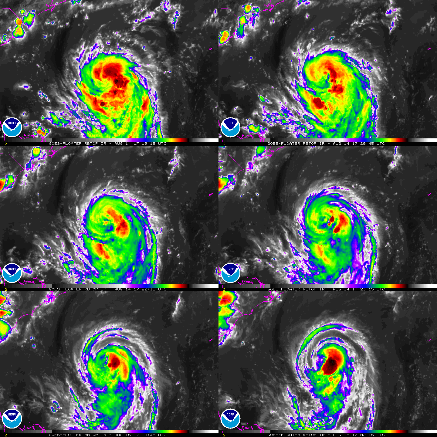
系統開始清空中心 建立風眼結構 NHC預測能衝擊颶風(巔峰預估70kts)
回復

使用道具 舉報

簽到天數: 3291 天

[LV.Master]伴壇終老

t02436|2017-8-15 11:04 | 顯示全部樓層
03Z評價65節升格C1,上調預期巔峰至90節。
000
WTNT43 KNHC 150236
TCDAT3

Hurricane Gert Discussion Number   9
NWS National Hurricane Center Miami FL       AL082017
1100 PM EDT Mon Aug 14 2017

Satellite images show that Gert has developed an eye, although the
convection is weak in the western eyewall.  Still, microwave images
show a healthy inner-core structure, with plenty of deep convection
in the eastern eyewall.  Satellite intensity estimates unanimously
support making Gert a hurricane on this advisory, and the initial
wind speed is set to 65 kt, close to the TAFB figure.

Some light or moderate northerly shear is forecast to continue to
affect Gert for the next day or so, which might limit the
intensification rate.  On Wednesday, however, the shear is forecast
to drop off as Gert accelerates northeastward over warm waters with
a large increase in upper-level divergence also noted.  This is
typically a favorable environment for intensification, and the
official forecast is raised from the previous one, lying between
the model consensus IVCN and the higher corrected consensus aids.
Gert is expected to complete extratropical transition within 72
hours, then gradually weaken over the North Atlantic before it
merges with a larger extratropical cyclone in 4 to 5 days.

Gert continues to move northward at about 7 kt.  The storm is
expected to turn north-northeastward and begin to accelerate
Tuesday ahead of a shortwave trough approaching the northeastern
United States.  Like the last cycle, the track guidance continues to
be in excellent agreement, but is generally slower than before.
The new forecast is on the fast side of the guidance, assuming that
Gert is a strong hurricane that stays vertically coherent in the
faster mid/upper-level flow.

Swells from Gert are expected to spread northward along the
mid-Atlantic coast of the United States during the next few days.
These swells are likely to produce dangerous surf and rip current
conditions.  Please consult products from your local National
Weather Service office.


FORECAST POSITIONS AND MAX WINDS

INIT  15/0300Z 31.2N  72.3W   65 KT  75 MPH
12H  15/1200Z 32.3N  72.0W   70 KT  80 MPH
24H  16/0000Z 34.3N  70.6W   75 KT  85 MPH
36H  16/1200Z 36.6N  66.9W   85 KT 100 MPH
48H  17/0000Z 39.3N  60.8W   90 KT 105 MPH
72H  18/0000Z 46.0N  46.0W   70 KT  80 MPH...POST-TROP/EXTRATROP
96H  19/0000Z 52.0N  37.0W   50 KT  60 MPH...POST-TROP/EXTRATROP
120H  20/0000Z...DISSIPATED

$$
Forecaster Blake
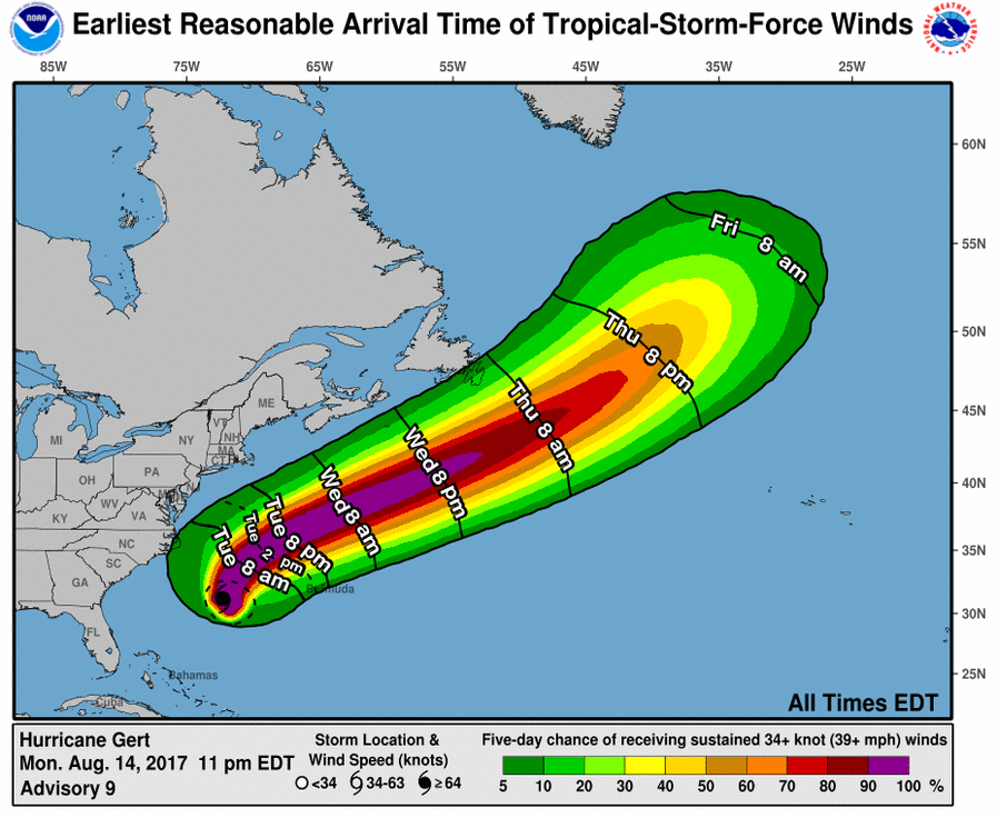
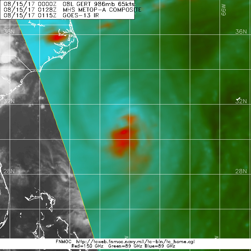
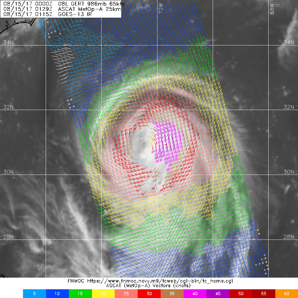
024204_earliest_reasonable_toa_34.png

20170815.0128.metopa.89rgb.08L.GERT.65kts.986mb.30.8N.72.3W.080pc.jpg

LATEST.jpg

rbtop-animated.gif
回復

使用道具 舉報

簽到天數: 588 天

[LV.9]以壇為家II

Meow|2017-8-16 21:16 | 顯示全部樓層
恐怖的來了
20170816.1300.goes13.x.vis1km.08LGERT.80kts-975mb-368N-671W.100pc.jpg
回復

使用道具 舉報

12下一頁
快速回覆
您需要登錄後才可以回帖 登錄 | 立即加入

本版積分規則

...

    主題

    帖子

    39萬

    積分

    12級[颶風Hurricane]

    Rank: 12Rank: 12Rank: 12

12級[颶風Hurricane]

發訊息

本平台僅供學術討論之用,預報應以氣象局為準

威普網站虛擬主機贊助公司

臺灣第一個天氣類型社群平台 即時天氣資訊、精準颱風動態

線上客服
FB傳送訊息
廣告行銷
精準行銷 物超所值
官方粉專
發佈 快速回復 返回頂部 返回列表