開啟輔助訪問
 找回密碼
 立即加入

07L.Franklin 近岸增強成為今年北大首颶風 巔峰二次登陸墨西哥

簽到天數: 2414 天

[LV.Master]伴壇終老

2017-8-4 01:37 | 顯示全部樓層
  一級颶風  
編號:07 L
名稱:Franklin

  基本資料  
擾動編號日期:2017 08 04 01
命名日期  :2017 08 07 11
撤編日期  :2017 08 11 19
登陸地點  :墨西哥 金塔納羅奧州
           維拉克魯茲州

  巔峰時期資料  
近中心最強風速
國家颶風中心(NHC):75 kts
海平面最低氣壓 :985 百帕

  過去路徑圖  
07L-Franklin.png
  擾動編號資料  
90L.INVEST.25kts.1012mb.12.2N.64.6W

20170802.1925.f15.goes-13.ir.90L.INVEST.25kts.1012mb.12.2N.64.6W.035pc.jpg

以上資料來自:NHC、颱風論壇整理製作

評分

參與人數 1水氣能量 +15 收起 理由
king111807 + 15

查看全部評分

回復

使用道具 舉報

簽到天數: 601 天

[LV.9]以壇為家II

霧峰追風者|2017-8-4 02:47 | 顯示全部樓層
NHC 展望10%
2. A strong tropical wave located over the southeastern Caribbean Sea
is producing a large area of cloudiness and thunderstorms, along
with tropical-storm-force wind gusts in squalls.  Environmental
conditions are expected to become a little more conducive for
development by Sunday over the northwestern Caribbean Sea and by
early next week over the Bay of Campeche while the disturbance
moves westward or west-northwestward at 15 to 20 mph.  This system
could produce brief heavy rainfall and gusty winds over Aruba,
Bonaire, and Curacao tonight and Friday.  For additional information
on this system, see High Seas Forecasts issued by the National
Weather Service.
* Formation chance through 48 hours...low...10 percent.
* Formation chance through 5 days...low...20 percent.
two_atl_2d2.png

回復

使用道具 舉報

簽到天數: 971 天

[LV.10]以壇為家III

jwpk9899|2017-8-6 15:30 | 顯示全部樓層
TCFA老半天沒人理他XD
al902017.20170805211349.gif

點評

NHC2日展望只給Medium(60%)  發表於 2017-8-7 00:45
回復

使用道具 舉報

簽到天數: 601 天

[LV.9]以壇為家II

霧峰追風者|2017-8-7 07:11 | 顯示全部樓層
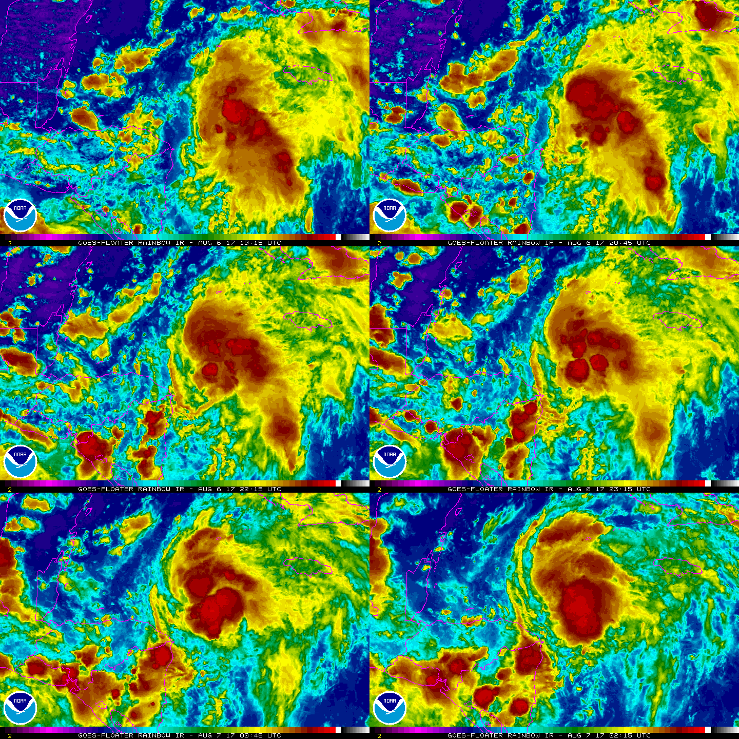
升格潛在熱帶氣旋07L,趨向墨西哥東南部。
000
WTNT42 KNHC 062036
TCDAT2

Potential Tropical Cyclone Seven Discussion Number   1
NWS National Hurricane Center Miami FL       AL072017
500 PM EDT Sun Aug 06 2017

Surface and scatterometer data indicate that the broad area of
low pressure over the northwestern Caribbean Sea still lacks a
well-defined center of circulation.  However, this system is
likely to become a tropical storm before reaching the coast of the
Yucatan Peninsula late tomorrow, and advisories are being initiated
to enable the issuance of a tropical storm warning and watch for
Yucatan and Belize respectively.  The scatterometer pass and NOAA
data buoy observations indicate that the maximum winds are near
30 kt.  The disturbance has been experiencing westerly vertical
shear due to a nearby upper-level low and this has been inhibiting
development.  Global model predictions show that this low will soon
dissipate and an upper-level anticyclone will become established
over the area.  Therefore, strengthening is likely with the main
impediment being interaction with land.  The official intensity
forecast is a little above the model consensus.  It should be
noted that the system could become a hurricane between 72 and 96
hours, i.e. prior to reaching the Gulf coast of Mexico.

Since the center lacks definition, the initial location and motion
are quite uncertain, and my best guess for the current motion is
290/10.  The steering pattern for the disturbance/tropical cyclone
is expected to be fairly straightforward and persistent for the
next few days.  A general west-northwestward track is expected to
continue until landfall in mainland Mexico.  The official track
forecast is generally a blend of the latest GFS and ECMWF solutions.

FORECAST POSITIONS AND MAX WINDS

INIT  06/2100Z 15.6N  82.0W   30 KT  35 MPH...POTENTIAL TROP CYCLONE
12H  07/0600Z 16.6N  83.6W   35 KT  40 MPH...TROPICAL CYCLONE
24H  07/1800Z 18.0N  85.9W   45 KT  50 MPH
36H  08/0600Z 19.0N  88.0W   45 KT  50 MPH...INLAND
48H  08/1800Z 19.9N  90.1W   35 KT  40 MPH...INLAND
72H  09/1800Z 21.0N  93.8W   60 KT  70 MPH...OVER WATER
96H  10/1800Z 21.2N  97.8W   60 KT  70 MPH...INLAND
120H  11/1800Z...DISSIPATED

$$
Forecaster Pasch
204233_5day_cone_no_line_and_wind.png rgb-animated (2).gif rbtop-animated (4).gif


回復

使用道具 舉報

簽到天數: 601 天

[LV.9]以壇為家II

霧峰追風者|2017-8-7 10:51 | 顯示全部樓層
本帖最後由 霧峰追風者 於 2017-8-7 11:03 編輯

NHC 命名"Franklin",逐漸增強,趨向墨西哥東南部。
000
WTNT42 KNHC 070245
TCDAT2

Tropical Storm Franklin Discussion Number   2
NWS National Hurricane Center Miami FL       AL072017
1100 PM EDT Sun Aug 06 2017

Last-light visible satellite pictures from GOES-13 and GOES-16
indicated that the low-level circulation of the disturbance had
become better defined and was located near the southwestern edge of
the main convective mass.  NOAA Buoy 42057, located about 90 n mi
northeast of the center, has reported peak 1-minute winds around 35
kt during the past few hours and a gust to 43 kt.  Because the
system has developed a closed circulation and well-defined center,
it is now classified as a tropical storm.  Franklin becomes the
sixth tropical storm of the 2017 Atlantic hurricane season.

The upper-level outflow is beginning to expand over the western
portion of the circulation, indicating that the shear over the
system is decreasing.  The global models are predicting that
Franklin will remain in a low-shear environment during the next
several days, and the only limiting factor for intensification
appears to be land interaction.  Additional strengthening is
expected before the cyclone reaches the Yucatan peninsula in about
24 hours.  After the system moves over the Bay of Campeche, warm
waters and favorable upper-level winds should allow for
restrengthening, and although not explicitly indicated in the
official forecast, Franklin could become a hurricane before it makes
final landfall in mainland Mexico.  The NHC forecast is closest to
the higher SHIPS guidance at 24 hours, and is near the intensity
consensus and HCCA models after that time.

The initial motion estimate is 295/11.  Franklin is forecast to
move west-northwestward during the next several days to the south
of a mid-level ridge that should remain in place over the northern
Gulf of Mexico.  The track model guidance has trended slightly
southward after 48 hours, and the new NHC track forecast has been
adjusted in that direction.  The NHC forecast remains near the
consensus of the GFS and ECMWF models.


FORECAST POSITIONS AND MAX WINDS

INIT  07/0300Z 16.4N  83.0W   35 KT  40 MPH
12H  07/1200Z 17.4N  84.9W   40 KT  45 MPH
24H  08/0000Z 18.5N  87.1W   50 KT  60 MPH
36H  08/1200Z 19.5N  89.3W   35 KT  40 MPH...INLAND
48H  09/0000Z 20.2N  91.3W   40 KT  45 MPH...OVER WATER
72H  10/0000Z 20.9N  95.2W   60 KT  70 MPH
96H  11/0000Z 21.0N  99.5W   35 KT  40 MPH...INLAND
120H  12/0000Z...DISSIPATED

$$
Forecaster Brown
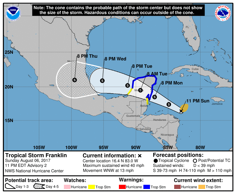
025051_5day_cone_no_line_and_wind.png rb-animated (1).gif

回復

使用道具 舉報

簽到天數: 3279 天

[LV.Master]伴壇終老

t02436|2017-8-8 02:11 | 顯示全部樓層
穩定移動中,有望在登陸前搞出一個風眼來,看能不能衝擊今年大西洋第一個颶風。
000
WTNT42 KNHC 071434
TCDAT2

Tropical Storm Franklin Discussion Number   4
NWS National Hurricane Center Miami FL       AL072017
1000 AM CDT Mon Aug 07 2017

Visible and microwave satellite imagery shows that Franklin's cloud
pattern is becoming better organized with banding features starting
to appear. Inner-core convection is not very abundant over the
southwest quadrant and the center is still estimated to be located
near the southwest edge of the main cloud mass.  Given the increase
in organization after the 12Z Dvorak intensity estimate of 45 kt
from TAFB, the advisory intensity is set to 50 kt.  An Air Force
Hurricane Hunter aircraft is scheduled to investigate Franklin this
afternoon and should provide a better estimate of the strength of
the storm.  The upper-level environment is becoming increasingly
conducive for intensification, with anticyclonic outflow becoming
established over the tropical cyclone during the next couple of
days. Franklin could become a hurricane before its first landfall,
but interaction with the Yucatan Peninsula will cause some weakening
on Tuesday.  Thereafter, Franklin will be moving over SSTs near 30
deg C, which of course favors strengthening.  A complicating factor
at days 2 and 3 could be some northerly shear associated with an
upper-level ridge over northeastern Mexico, as indicated by the
global models.  Nonetheless Franklin should be near or at hurricane
intensity by the time it makes landfall in mainland Mexico.  The
official intensity forecast is a little above the model consensus.

The initial motion continues to be west-northwestward or 300/12 kt.
Little changes have been made to the track forecast from previous
advisories.  The steering environment remains fairly simple, and is
dominated by a zonally-oriented ridge that should cause a
west-northwestward to westward motion for the next several days.
The official track forecast is close to the dynamical model
consensus TVCN and leans slightly toward the ECMWF at the end of
the period.

FORECAST POSITIONS AND MAX WINDS

INIT  07/1500Z 17.7N  85.1W   50 KT  60 MPH
12H  08/0000Z 18.5N  86.8W   60 KT  70 MPH
24H  08/1200Z 19.5N  88.9W   40 KT  45 MPH...INLAND
36H  09/0000Z 20.1N  91.1W   45 KT  50 MPH...OVER WATER
48H  09/1200Z 20.5N  93.3W   60 KT  70 MPH...OVER WATER
72H  10/1200Z 20.8N  97.8W   60 KT  70 MPH...INLAND
96H  11/1200Z...DISSIPATED

$$
Forecaster Pasch

175200_5day_cone_with_line.png

LATEST.jpg

20170807.1238.f18.91pct91h91v.07L.FRANKLIN.45kts.1004mb.17.4N.84.6W.065pc.jpg

20170807.1715.goes-13.ircolor.07L.FRANKLIN.45kts.1004mb.17.4N.84.6W.100pc.jpg

vis-animated.gif
回復

使用道具 舉報

簽到天數: 3279 天

[LV.Master]伴壇終老

t02436|2017-8-8 12:44 | 顯示全部樓層
登陸消息,中心已經登陸墨西哥。
000
WTNT62 KNHC 080402
TCUAT2

Tropical Storm Franklin Tropical Cyclone Update
NWS National Hurricane Center Miami FL       AL072017
1100 PM CDT Mon Aug 07 2017


..FRANKLIN MAKES LANDFALL ALONG THE EAST COAST OF THE YUCATAN
PENINSULA...


High resolution data from the new NOAA GOES-16 satellite, along
with radar imagery from the Belize City Doppler weather radar,
indicate that the center of Tropical Storm Franklin made landfall
near Pulticub, Mexico, at approximately 1045 PM CDT...0345 UTC...

with maximum sustained winds near 60 mph (95 km/h).


SUMMARY OF 1100 PM CDT...0400 UTC...INFORMATION
-----------------------------------------------
LOCATION...19.1N 87.5W
ABOUT 15 MI...25 KM SSW OF PUNTA HERRERO MEXICO
ABOUT 25 MI...45 KM NNE OF PUERTO COSTA MAYA MEXICO
MAXIMUM SUSTAINED WINDS...60 MPH...95 KM/H
PRESENT MOVEMENT...WNW OR 300 DEGREES AT 14 MPH...22 KM/H
MINIMUM CENTRAL PRESSURE...995 MB...29.39 INCHES

$$
Forecaster Stewart/Landsea

024710_5day_cone_with_line.png

rbtop-animated.gif

貝里斯雷達
Franklin_7Aug17_Belize.gif

recon_AF304-0107A-FRANKLIN_timeseries.png

recon_AF304-0107A-FRANKLIN.png
回復

使用道具 舉報

簽到天數: 601 天

[LV.9]以壇為家II

霧峰追風者|2017-8-9 08:22 | 顯示全部樓層
稍早中心已經進入墨西哥灣,結構重新增強,預計2天後再次登陸墨西哥中部。
000
WTNT42 KNHC 082033
TCDAT2

Tropical Storm Franklin Discussion Number   9
NWS National Hurricane Center Miami FL       AL072017
400 PM CDT Tue Aug 08 2017

Visible satellite images and surface synoptic data indicate that
the center of the cyclone is nearing the northwest coast of the
Yucatan Peninsula.  The overall cloud pattern remains fairly well
organized, with distinct banding features and well-defined
upper-level outflow.  Based on the assumption that only slow
weakening has been occurring, the current intensity is set at 35 kt.
Franklin should begin to strengthen very soon, when its center moves
over the warm waters of the Bay of Campeche.  The dynamical
guidance indicates that north-northeasterly shear will begin to
affect the tropical cyclone when it moves farther west in the
southwestern Gulf of Mexico, which should be an impediment for
strengthening. The official intensity forecast is above the SHIPS
and LGEM guidance but close to the intensity model consensus.  Given
that it is quite possible that Franklin could become a hurricane by
the time of landfall, it is prudent to maintain the Hurricane Watch
for the southwest Gulf coast of Mexico.

The motion continues west-northwestward or 290/10 kt.  A
mid-tropospheric high pressure area near the northwestern Gulf
coast should cause a generally westward motion over the next couple
of days.  The official track forecast is similar to the previous
ones, and not far from the latest dynamical model consensus.

FORECAST POSITIONS AND MAX WINDS

INIT  08/2100Z 20.2N  90.3W   35 KT  40 MPH
12H  09/0600Z 20.5N  91.9W   40 KT  45 MPH...OVER WATER
24H  09/1800Z 20.6N  94.0W   50 KT  60 MPH
36H  10/0600Z 20.7N  96.2W   60 KT  70 MPH
48H  10/1800Z 20.4N  98.2W   30 KT  35 MPH...INLAND
72H  11/1800Z...DISSIPATED

$$
Forecaster Pasch
234822_5day_cone_no_line_and_wind.png rbtop-animated (5).gif

回復

使用道具 舉報

12下一頁
快速回覆
您需要登錄後才可以回帖 登錄 | 立即加入

本版積分規則

本平台僅供學術討論之用,預報應以氣象局為準

威普網站虛擬主機贊助公司

臺灣第一個天氣類型社群平台 即時天氣資訊、精準颱風動態

線上客服
FB傳送訊息
廣告行銷
精準行銷 物超所值
官方粉專
發佈 快速回復 返回頂部 返回列表