開啟輔助訪問
 找回密碼
 立即加入

13E.Kenneth 海溫降低 逐漸減弱

簽到天數: 2087 天

[LV.Master]伴壇終老

2017-8-17 11:17 | 顯示全部樓層
本帖最後由 周子堯@FB 於 2017-8-22 13:09 編輯

  四級颶風  
編號:13 E
名稱:Kenneth

  基本資料  
擾動編號日期:2017 08 17 10
命名日期  :2017 08 19 11
撤編日期  :2017 08 00 00
登陸地點  :暫無

  巔峰時期資料  
近中心最強風速
國家颶風中心(NHC):115 kts
海平面最低氣壓 :952 百帕

  過去路徑圖  

  擾動編號資料  
93E.INVEST.25kts.1008mb.10.9N.108.2W

20170817.0118.f18.x.ir1km_bw.93EINVEST.25kts-1008mb-109N-1082W.100pc.jpg

NHC:20%
1. A broad area of low pressure located about 600 miles south-
southwest of Manzanillo, Mexico, is producing disorganized showers
and thunderstorms.  Environmental conditions are expected to be
conducive for some development during the next several days while
the system moves west-northwestward at 10 to 15 mph.
* Formation chance through 48 hours...low...20 percent.
* Formation chance through 5 days...low...30 percent.

93E.PNG
以上資料來自:NHC、颱風論壇整理製作

點評

話說, 寫錯了吧 . 一級颶風下面那行是13E 才對  發表於 2017-8-21 11:50
展望已經High囉  發表於 2017-8-18 14:10
嗯嗯~謝謝總監~  發表於 2017-8-17 11:30
10點就編號囉,圖我幫你補吧  發表於 2017-8-17 11:25

評分

參與人數 1水氣能量 +15 收起 理由
t02436 + 15

查看全部評分

回復

使用道具 舉報

簽到天數: 601 天

[LV.9]以壇為家II

霧峰追風者|2017-8-18 00:13 | 顯示全部樓層
NHC 展望提升至40%
1. An area of low pressure is located about 600 miles south-southwest
of Manzanillo, Mexico.  This system has a broad circulation, but
the associated shower and thunderstorm activity remains
disorganized. Environmental conditions are expected to be generally
conducive for gradual development, and a tropical depression may
form within the next few days while it moves west-northwestward
at 10 to 15 mph.
* Formation chance through 48 hours...medium...40 percent.
* Formation chance through 5 days...medium...60 percent.
two_pac_2d1 (2).png


回復

使用道具 舉報

簽到天數: 601 天

[LV.9]以壇為家II

霧峰追風者|2017-8-18 09:55 | 顯示全部樓層
NHC 展望提升至70%
1. Showers and thunderstorms associated with a low pressure system
located several hundred miles south-southwest of the southern tip
of the Baja California peninsula continue to show some signs of
organization.  Environmental conditions are expected to be
conducive for additional development while the system moves
west-northwestward at about 15 mph, and a tropical depression is
likely to form by early next week before the low reaches colder
waters.
* Formation chance through 48 hours...high...70 percent.
* Formation chance through 5 days...high...80 percent.
two_pac_2d1 (3).png

回復

使用道具 舉報

簽到天數: 3279 天

[LV.Master]伴壇終老

t02436|2017-8-18 22:49 | 顯示全部樓層
升格13E,上望一級颶風。
000
WTPZ43 KNHC 181441
TCDEP3

Tropical Depression Thirteen-E Discussion Number   1
NWS National Hurricane Center Miami FL       EP132017
800 AM PDT Fri Aug 18 2017

Deep convection associated with the disturbance located over the
open eastern Pacific Ocean has become better organized early this
morning, and a primary convective band now wraps around the western
half of the circulation.  Shortwave-IR and first-light visible
imagery suggest that a complex, but closed surface circulation
exists. NHC is therefore initiating advisories on Tropical
Depression Thirteen-E.

The initial intensity is set at 30 kt, in agreement with the max
winds measured in an earlier ASCAT pass and the latest Dvorak
classification from TAFB.  Light easterly vertical wind shear has
thus far limited convection to the western half of the circulation,
but the GFS and ECMWF agree that the shear will lessen as the system
moves farther west.  Overall, the environment appears conducive for
intensification for the next 3 days or so, and the NHC forecast
indicates that the cyclone will become a hurricane by the end of
this weekend.  After that time, the cyclone will begin to weaken
over much cooler waters.  The NHC forecast is very close to the
multi-model consensus, IVCN.

Since the center has only recently formed, the initial motion
estimate is a fairly uncertain 285/13 kt.  There is fairly good
agreement among the global models that the tropical cyclone will
move generally westward to west-northwestward for the next 72 h
along the southern boundary of a mid-level ridge that extends
westward well into the eastern Pacific basin.  A weakness in the
ridge is forecast to develop in about 3 days that should cause
the cyclone to slow and turn more toward the northwest and
eventually toward the north-northwest.  The official forecast is
close to a blend of the GFS and ECMWF models.


FORECAST POSITIONS AND MAX WINDS

INIT  18/1500Z 14.8N 116.5W   30 KT  35 MPH
12H  19/0000Z 15.4N 118.4W   35 KT  40 MPH
24H  19/1200Z 15.9N 121.0W   45 KT  50 MPH
36H  20/0000Z 16.6N 123.6W   55 KT  65 MPH
48H  20/1200Z 17.3N 126.1W   65 KT  75 MPH
72H  21/1200Z 19.1N 130.3W   75 KT  85 MPH
96H  22/1200Z 21.4N 132.4W   65 KT  75 MPH
120H  23/1200Z 23.6N 133.3W   45 KT  50 MPH

$$
Forecaster Zelinsky

144720_5day_cone_with_line.png

rbtop-animated.gif
回復

使用道具 舉報

簽到天數: 3279 天

[LV.Master]伴壇終老

t02436|2017-8-19 11:23 | 顯示全部樓層
命名kenneth
000
WTPZ43 KNHC 190231
TCDEP3

Tropical Storm Kenneth Discussion Number   3
NWS National Hurricane Center Miami FL       EP132017
800 PM PDT Fri Aug 18 2017

Conventional satellite imagery and an earlier SSMI/S overpass show
that the depression has been strengthening during the past several
hours.  Impressive outer curved banding has developed in the eastern
and northern portions of the cyclone, and the last few visible
images are showing early signs of a small central dense overcast, or
inner core formation.  Based on the overall improvement of the cloud
pattern and Dvorak satellite intensity estimates of 35 kt from
SAB and TAFB, the depression is upgraded to Tropical Storm Kenneth.

The northeasterly shear is diminishing, the oceanic temperatures are
warm, and the low to mid levels of the atmosphere are moist, all
bolstering further strengthening through the 48-hour period.
Afterward, decreasing sea surface temperatures and an intruding
stable air mass from the north should result in gradual weakening.
No significant changes were made to the previous intensity forecast,
and the NHC forecast is based primarily on the IVCN multi-model
consensus.

The initial motion is estimated to be westward, or 280/13 kt.
Kenneth is embedded in the easterly mid-level flow of a subtropical
ridge extending over the eastern Pacific from northern Mexico.  The
cyclone should commence a gradual turn toward the west-northwest
around the 24-hour period as a mid- to upper-level low located
just southwest of the southern California coast amplifies and
erodes the ridge to the northwest of Kenneth.  Kenneth's motion is
expected to be further influenced by this growing weakness in the
ridge by decreasing in forward speed, turning northwestward on
day 3, and then north-northwestward around the 96-hour period.  The
guidance suite is surprisingly tightly clustered through the entire
forecast period.  The NHC track forecast is similar to the previous
one, and is hedged toward the HCCA corrected consensus model.


FORECAST POSITIONS AND MAX WINDS

INIT  19/0300Z 15.0N 119.1W   35 KT  40 MPH
12H  19/1200Z 15.4N 121.2W   45 KT  50 MPH
24H  20/0000Z 16.0N 124.1W   55 KT  65 MPH
36H  20/1200Z 16.8N 126.7W   65 KT  75 MPH
48H  21/0000Z 17.7N 128.9W   75 KT  85 MPH
72H  22/0000Z 19.6N 131.8W   70 KT  80 MPH
96H  23/0000Z 22.3N 133.1W   60 KT  70 MPH
120H  24/0000Z 25.2N 133.9W   45 KT  50 MPH

$$
Forecaster Roberts

023737_5day_cone_with_line.png

rbtop-animated.gif
回復

使用道具 舉報

簽到天數: 3279 天

[LV.Master]伴壇終老

t02436|2017-8-21 02:26 | 顯示全部樓層
風眼開了,15Z上C1。
000
WTPZ43 KNHC 201432
TCDEP3

Hurricane Kenneth Discussion Number   9
NWS National Hurricane Center Miami FL       EP132017
800 AM PDT Sun Aug 20 2017

Kenneth is gradually strengthening.  Satellite images show that the
cloud pattern consists of a central dense overcast and curved bands
beyond that feature, especially to the south of the center.  The
Dvorak classifications from TAFB and SAB were both 4.0/65 kt, and
recent ADT values from CIMSS at the University of Wisconsin are
about the same.  Based on these data, the initial intensity is
increased a little to 65 kt, making Kenneth a category 1 hurricane.

The initial motion of the hurricane is the same as before, 280/13
kt.  A turn to the northwest with a decrease in forward speed is
expected to occur on Monday as a mid-level ridge to the northeast of
the system weakens.  After that time, Kenneth is expected to move
even slower to the north-northwest when it moves into a break in the
ridge caused by a cut-off low near the southwestern United States.
Overall the models are in fair agreement with this scenario, but
they differ in where and when Kenneth begins to recurve.  The
consensus aids have been quite consistent over the past few cycles,
and this forecast is largely just an update of the previous one.

The environmental conditions are conducive for Kenneth to strengthen
some more during the next 24 to 36 hours.  After that time,
however, cooler waters along the expected track and drier air
should end the strengthening trend and cause weakening.  In
addition, the global models show a significant increase in
southerly shear beginning in about 72 hours, which should aid in
the weakening trend.  The intensity models are in very good
agreement, and little change was made to the previous forecast.
Kenneth will likely become a post-tropical cyclone in 4 to 5 days
when it will be over SSTs of about 23 deg C.

FORECAST POSITIONS AND MAX WINDS

INIT  20/1500Z 16.3N 127.4W   65 KT  75 MPH
12H  21/0000Z 16.8N 129.1W   70 KT  80 MPH
24H  21/1200Z 17.8N 131.0W   75 KT  85 MPH
36H  22/0000Z 19.0N 132.4W   75 KT  85 MPH
48H  22/1200Z 20.4N 133.4W   70 KT  80 MPH
72H  23/1200Z 23.7N 134.8W   55 KT  65 MPH
96H  24/1200Z 26.7N 136.3W   40 KT  45 MPH
120H  25/1200Z 28.0N 137.0W   30 KT  35 MPH...POST-TROP/REMNT LOW

$$
Forecaster Cangialosi

143725_5day_cone_with_line.png

20170820.1501.f18.91pct91h91v.13E.KENNETH.65kts.990mb.16.1N.126.9W.100pc.jpg

vis-animated.gif
回復

使用道具 舉報

簽到天數: 582 天

[LV.9]以壇為家II

蜜露|2017-8-21 11:48 | 顯示全部樓層


強度上超出預期的發展 .  

從最初C2 發展到可能是C4的情形 .

挑戰中颱上限有可能 .
2017EP13_4KMSRBDC_201708210230.jpg \\


bandicam 2017-08-21 11-39-12-415.jpg


20170821.0156.gpm.x.colorpct_89h_89v.13EKENNETH.95kts-967mb-166N-1287W.64pc.jpg

回復

使用道具 舉報

簽到天數: 3279 天

[LV.Master]伴壇終老

t02436|2017-8-21 11:59 | 顯示全部樓層
03Z直接評價100節:o
000
WTPZ43 KNHC 210252
TCDEP3

Hurricane Kenneth Discussion Number  11
NWS National Hurricane Center Miami FL       EP132017
800 PM PDT Sun Aug 20 2017

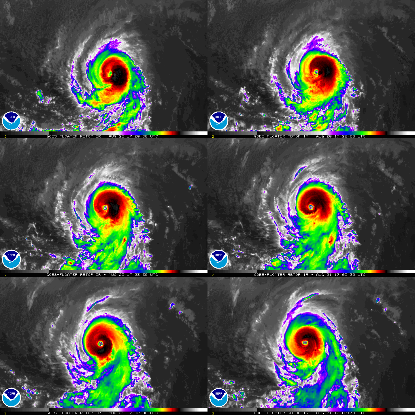
Kenneth has rapidly intensified into a major hurricane this
evening, as the eye has dramatically warmed and the surrounding
cloud tops of the eyewall have cooled.  At 00Z, a blend of TAFB,
SAB, and ADT Dvorak classifications averaged maximum winds of
95 kt. However, the continued convective development in the last
three hours suggests that the advisory intensity be boosted to
100 kt, and even that may be conservative.

While the hurricane has shown an impressive evolution in the last
day, this should not continue much longer.  Kenneth will reach the
26C SST isotherm with drier, less unstable air late Monday, and it
is anticipated that Kenneth will peak by then.  In about three
days, the vertical shear will go up appreciably due to Kenneth
approaching an upper-level trough.  The combination of the hostile
thermodynamics and shear should cause a steady weakening through
the forecast period.  Kenneth's deep convection is likely to
dissipate in three to four days, signaling the system's
transformation to a post-tropical cyclone.  The official intensity
forecast is substantially higher than previously in the short-term
due to the unanticipated rapid intensification, but similar for 36
hours and beyond.  This prediction is closest to a blend of the HMON
dynamical model and the LGEM/SHIPS statistical models.

The hurricane is moving toward the west-northwest at 9 kt, steered
by a weak mid-level ridge to its northeast.  Kenneth should
gradually turn toward the north-northwest during the next couple of
days at about the same rate of forward speed, as it rounds the
mid-level ridge and is impacted by a cut-off mid- to upper-level low
farther north.  Once Kenneth becomes a post-tropical cyclone in
about 4 days, its forward speed should slow as it reaches a weaker
steering flow.  The official track forecast is nearly unchanged
through day 2 and is farther north beyond that time, based upon the
HFIP Corrected Consensus Approach.


FORECAST POSITIONS AND MAX WINDS

INIT  21/0300Z 16.8N 129.1W  100 KT 115 MPH
12H  21/1200Z 17.4N 130.4W  110 KT 125 MPH
24H  22/0000Z 18.7N 131.7W  100 KT 115 MPH
36H  22/1200Z 20.3N 132.7W   85 KT 100 MPH
48H  23/0000Z 22.1N 133.6W   70 KT  80 MPH
72H  24/0000Z 25.5N 135.0W   50 KT  60 MPH
96H  25/0000Z 28.5N 136.0W   40 KT  45 MPH...POST-TROPICAL
120H  26/0000Z 30.0N 136.5W   30 KT  35 MPH...POST-TROP/REMNT LOW

$$
Forecaster Landsea
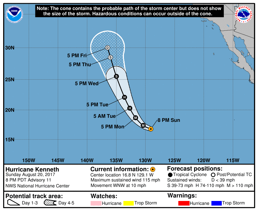
030130_5day_cone_with_line.png

rbtop-animated.gif

點評

上看120kts.930hpa,但時間不多了,sst快低於26度  發表於 2017-8-21 12:33
回復

使用道具 舉報

12下一頁
快速回覆
您需要登錄後才可以回帖 登錄 | 立即加入

本版積分規則

本平台僅供學術討論之用,預報應以氣象局為準

威普網站虛擬主機贊助公司

臺灣第一個天氣類型社群平台 即時天氣資訊、精準颱風動態

線上客服
FB傳送訊息
廣告行銷
精準行銷 物超所值
官方粉專
發佈 快速回復 返回頂部 返回列表