開啟輔助訪問
 找回密碼
 立即加入

17L.Ophelia 少見高緯MH 北上侵襲愛爾蘭轉化溫氣

簽到天數: 3279 天

[LV.Master]伴壇終老

t02436|2017-10-14 21:00 | 顯示全部樓層
北大把握機會季末再刷一波,速報站上MH。
17L OPHELIA 171014 1200  34.2N   27.7W ATL   100   960


20171014.0858.f17.91pct91h91v.17L.OPHELIA.85kts.971mb.33.4N.29.7W.095pc.jpg

20171014.1145.goes-13.ircolor.17L.OPHELIA.85kts.971mb.33.4N.29.7W.100pc.jpg

20171014.1215.goes-13.vis.1km.17L.OPHELIA.85kts.971mb.33.4N.29.7W.100pc.jpg

點評

奇蹟颶風  發表於 2017-10-14 22:14
回復

使用道具 舉報

簽到天數: 3279 天

[LV.Master]伴壇終老

t02436|2017-10-14 22:56 | 顯示全部樓層
正報100節確定!
000
WTNT42 KNHC 141438
TCDAT2

Hurricane Ophelia Discussion Number  22
NWS National Hurricane Center Miami FL       AL172017
1100 AM AST Sat Oct 14 2017

During the past few hours, Ophelia's satellite presentation has
improved significantly. The eye has become even more distinct
with a temperature of 16 deg C, and has been surrounded by very
deep convection.
T-numbers from TAFB and SAB have reached 5.5 on the
Dvorak scale, and the objective numbers from CIMMS have been
oscillating around T5.8 and T5.9 recently. Based on these estimates,
the initial intensity has been increased conservatively to 100 kt,
making Ophelia a category 3 hurricane on the SSHS.  Ophelia is a
quite intense and rare hurricane for its location in the
northeastern Atlantic.
Increasing shear and cold waters will
soon begin to impact Ophelia, and the hurricane should begin to
acquire extratropical characteristics in about 36 hours or sooner.
Although some weakening is anticipated, Ophelia is expected to reach
the British Isles as a powerful extratropical cyclone with hurricane
force winds. Dissipation is forecast in about 4 days after the
system moved over these Isles.

Satellite fixes indicate that Ophelia is moving toward the northeast
or 055 degrees at 22 kt. The hurricane is well embedded within the
southwesterly flow associated with the southern extension of a large
mid-latitude trough, and this pattern should continue to steer the
cyclone northeastward and north-northeastward with increasing
forward speed for the next 2 to 3 days until dissipation. Track
models are in excellent agreement and the guidance envelope is quite
tight. The NHC forecast is not different from previous ones, and it
is very close to the HFIP corrected consensus HCCA and the
multi-model ensemble TVCX.

Given that Ophelia is forecast to become extratropical, the wind
field should expand, resulting in impacts over portions of the
British Isles regardless of its exact location or strength.

Although the center of Ophelia is not forecast to reach Ireland or
the UK for another couple of days, wind and rains will arrive
well in advance of the cyclone center. Individuals in those
locations should consult products from their local meteorological
service for more information on local impacts.

Tropical-storm-force winds are possible throughout the Azores
after Ophelia passes to the south and east later today and tonight
as a cold front moves through the islands.  Interests in the Azores
should refer to products issued by the Azores Weather Forecast and
Watch Center.

KEY MESSAGES:

1. Ophelia is expected to be a powerful extratropical cyclone with
hurricane force winds Monday while it moves near Ireland and the
United Kingdom.  Direct impacts from wind and heavy rain in portions
of these areas are likely, along with dangerous marine conditions.
For more details on the magnitude, timing, and location of impacts
from post-tropical Ophelia, residents in Ireland should refer to
products issued by Met Eireann, and residents in the United Kingdom
should refer to products issued by the Met Office.


FORECAST POSITIONS AND MAX WINDS

INIT  14/1500Z 34.8N  26.6W  100 KT 115 MPH
12H  15/0000Z 36.5N  23.0W   95 KT 110 MPH
24H  15/1200Z 40.5N  18.0W   90 KT 105 MPH
36H  16/0000Z 46.5N  14.0W   85 KT 100 MPH...POST-TROP/EXTRATROP
48H  16/1200Z 51.5N  11.0W   75 KT  85 MPH...POST-TROP/EXTRATROP
72H  17/1200Z 59.0N   6.0W   40 KT  45 MPH...POST-TROP/EXTRATROP
96H  18/1200Z...DISSIPATED

$$
Forecaster Avila

144425_5day_cone_with_line.png

LATEST.jpg

20171014.1415.goes-13.ircolor.17L.OPHELIA.100kts.960mb.34.2N.27.7W.100pc.jpg
回復

使用道具 舉報

簽到天數: 241 天

[LV.8]以壇為家I

krichard2011|2017-10-14 23:15 | 顯示全部樓層
歐菲莉亞颶風(Hurricane Ophelia)
算是一個很特別的颶風 由溫帶氣旋轉暖
附近海溫 24~25度 海洋熱含量完全等於"0"的'ˋ狀態下
不只維持住了自己的強度還增強到3級颶風(100KT)
成為今年大西洋第6個達到強烈颶風等級的颶風
增強機制主要是高層大氣溫度較平均值低
而高低層的溫度差 使得大氣不穩定度增加
這狀況類似之前的 Alex 颶風

以下是 MODIS Terra 衛星拍到的影像
image-download.jpg
2017AL17_OHCNFCST_201710140600.gif
回復

使用道具 舉報

簽到天數: 582 天

[LV.9]以壇為家II

蜜露|2017-10-15 00:58 | 顯示全部樓層
本帖最後由 蜜露 於 2017-10-15 00:59 編輯


颶風歐菲莉亞升格Cat.3  100Kts

今年大西洋颶風真猛

哈維 Cat.4 115Kts  艾瑪 Cat.5 160Kts 荷西 Cat.4 135Kts 卡蒂亞 Cat.2 90Kts 李 Cat.3 100Kts 瑪麗亞 Cat.5 145Kts 耐特 Cat.2 80Kts 歐菲莉亞 Cat.3 100Kts


20170927.1815.goes-13.ircolor.14L.LEE.100kts.963mb.30.3N.56.5W.100pc.jpg
(李)

20171014.1445.goes-13.ircolor.17L.OPHELIA.100kts.960mb.34.2N.27.7W.100pc.jpg

(歐菲莉亞)

這兩個颶風(上圖-李 & 下圖-歐菲莉亞)還真有點相似, 只有B環 , 其中歐菲莉亞未來還有可能擦到愛爾蘭??
對於歐洲從沒有這體驗 , 這路徑簡直真不可思議.

144425_5day_cone_no_line_and_wind.png


回復

使用道具 舉報

簽到天數: 3279 天

[LV.Master]伴壇終老

t02436|2017-10-16 00:28 | 顯示全部樓層
80節,即將轉化,24小時內登陸愛爾蘭。
000
WTNT42 KNHC 151445
TCDAT2

Hurricane Ophelia Discussion Number  26
NWS National Hurricane Center Miami FL       AL172017
1100 AM AST Sun Oct 15 2017

After displaying a distinct eye overnight, recent satellite imagery
indicate that the cloud pattern of Ophelia has begun to deteriorate
and the eye is no longer apparent. The deep convection is also
weakening fast and consequently, Dvorak numbers have begun to
decrease while analysts are trying to lower them as much as the
technique allows. The best estimate of the initial intensity is 80
kt. Given the cold waters of about 20 deg C, and the strong shear,
Ophelia is forecast to gradually weaken and become a post-tropical
cyclone later today.

Satellite fixes indicate that Ophelia is moving toward the
north-northeast or 025 degrees at 33 kt, well embedded within the
fast flow ahead of a large trough. This pattern is expected to
persist, so no significant change in track is anticipated before
dissipation. Guidance continues to be in remarkably good agreement
and most of the models bring a weakened post-tropical Ophelia to the
southern coast of Ireland Monday morning (AST or Miami time).
Thereafter, the cyclone will continue over northern Great Britain
until dissipation.

Strong winds and rains associated with Post-Tropical Ophelia will
arrive well in advance of the cyclone center. Residents in those
locations should consult products from their local meteorological
service for more information on local impacts.

KEY MESSAGES:

1. Ophelia is expected to be a powerful extratropical cyclone with
hurricane force winds while it moves near Ireland and the United
Kingdom.  Direct impacts from wind and heavy rain in portions of
these areas are likely, along with dangerous marine conditions. For
more details on the magnitude, timing, and location of impacts from
post-tropical Ophelia, residents in Ireland should refer to products
issued by Met Eireann, and residents in the United Kingdom should
refer to products issued by the Met Office.


FORECAST POSITIONS AND MAX WINDS

INIT  15/1500Z 41.6N  16.0W   80 KT  90 MPH
12H  16/0000Z 46.0N  13.0W   75 KT  85 MPH...POST-TROP/EXTRATROP
24H  16/1200Z 51.5N   9.5W   65 KT  75 MPH...POST-TROP/EXTRATROP
36H  17/0000Z 57.0N   5.0W   50 KT  60 MPH...POST-TROP/EXTRATROP
48H  17/1200Z 60.5N   1.5W   35 KT  40 MPH...POST-TROP/EXTRATROP
72H  18/1200Z...DISSIPATED

$$
Forecaster Avila

145012_5day_cone_with_line.png

A_e_sfc_color.png

Ophelia_15-16Oct17_ireland.gif

20171015.1530.msg-3.ircolor.17L.OPHELIA.80kts.973mb.40.1N.16.9W.100pc.jpg

al172017.20171015150347.gif

回復

使用道具 舉報

簽到天數: 3279 天

[LV.Master]伴壇終老

t02436|2017-10-16 13:47 | 顯示全部樓層
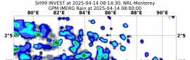
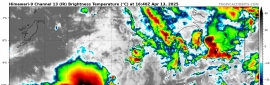
03Z判定以75節強度轉化,首波明顯降雨已抵達愛爾蘭。
000
WTNT42 KNHC 160252
TCDAT2

Post-Tropical Cyclone Ophelia Discussion Number  28
NWS National Hurricane Center Miami FL       AL172017
1100 PM AST Sun Oct 15 2017

Within just the past six hours, the last bit of deep convection
near Ophelia's center has been sheared off well to the north, and
the cyclone has acquired a definitive extratropical structure.
Ophelia has completed its transition to an occluded low, with an
attached warm front extending northeastward across Ireland and a
cold front draped southeastward toward Spain and Portugal.  The
powerful cyclone continues to produce hurricane-force winds, with
recent ASCAT data showing wind vectors as high as 70 kt to the east
of the center.  Based on these data, the initial intensity remains
75 kt to account for undersampling.  The occluded low is forecast to
gradually fill and weaken during the next couple of days, and it is
likely to dissipate near the western coast of Norway by 48 hours.
Despite the expected weakening, the post-tropical cyclone is still
likely to bring hurricane-force winds, especially in gusts, to
portions of western Ireland on Monday.

Ophelia has accelerated and retrograded slightly during the past
6-12 hours during the occlusion process, and the long-term motion
estimate is northward, or 010/38 kt.  Now that occlusion is
complete, the post-tropical cyclone should resume a north-
northeastward motion, with some decrease in forward speed, within
the next 12 hours.  That heading should continue for the ensuing day
or two, bringing the center of the cyclone near the western coast of
Ireland on Monday and then near northern Scotland Monday night.
The dynamical track models remain in good agreement on this
scenario, and the updated NHC forecast is not too different from
the previous one.

This is the last advisory issued by the National Hurricane Center
now that Ophelia has become post-tropical.  Local forecasts,
warnings, and other communications regarding the post-tropical
cyclone that are pertinent to Ireland and the United Kingdom will
continue to be available from Met Eireann and the UK Met Office.


KEY MESSAGES:

1. Ophelia will remain a powerful extratropical cyclone with
hurricane-force winds while it moves near Ireland and the United
Kingdom Monday and Monday night.  Strong winds and heavy rain are
likely in portions of these areas, along with dangerous marine
conditions.  For more details on the magnitude, timing, and location
of impacts from post-tropical Ophelia, residents in Ireland should
refer to products issued by Met Eireann, and residents in the
United Kingdom should refer to products issued by the Met Office.

2. Individuals are urged to not focus on the exact track of Ophelia
since strong winds and heavy rainfall will extend well outside of
the NHC forecast cone.


FORECAST POSITIONS AND MAX WINDS

INIT  16/0300Z 49.2N  13.3W   75 KT  85 MPH...POST-TROP/EXTRATROP
12H  16/1200Z 53.2N  10.1W   65 KT  75 MPH...POST-TROP/EXTRATROP
24H  17/0000Z 57.4N   5.9W   50 KT  60 MPH...POST-TROP/EXTRATROP
36H  17/1200Z 61.9N   0.1W   40 KT  45 MPH...POST-TROP/EXTRATROP
48H  18/0000Z...DISSIPATED

$$
Forecaster Berg

025759_5day_cone_with_line_and_wind.png

20171016.0430.msg-3.ircolor.17L.OPHELIA.70kts.969mb.47.6N.13.4W.100pc.jpg

A_e_sfc_color.png

Ophelia_15-16Oct17_ireland.gif
回復

使用道具 舉報

12
快速回覆
您需要登錄後才可以回帖 登錄 | 立即加入

本版積分規則

本平台僅供學術討論之用,預報應以氣象局為準

威普網站虛擬主機贊助公司

臺灣第一個天氣類型社群平台 即時天氣資訊、精準颱風動態

線上客服
FB傳送訊息
廣告行銷
精準行銷 物超所值
官方粉專
發佈 快速回復 返回頂部 返回列表