開啟輔助訪問
 找回密碼
 立即加入

01S.Dahlia 印尼海域短時間內再迎命名氣旋

簽到天數: 601 天

[LV.9]以壇為家II

霧峰追風者|2017-11-30 09:23 | 顯示全部樓層
JTWC 00Z速報升格"TS",編號01S,逐漸增強。
20171130.0030.himawari-8.ircolor.01S.DAHLIA.35kts.996mb.8.9S.104.4E.100pc.jpg rbtop-animated (1).gif

回復

使用道具 舉報

簽到天數: 601 天

[LV.9]以壇為家II

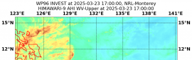
霧峰追風者|2017-12-1 11:28 | 顯示全部樓層
BoM 上望三級熱帶氣旋,逐漸南下。
IDW27700
TROPICAL CYCLONE TECHNICAL BULLETIN: AUSTRALIA - WESTERN REGION
Issued by PERTH TROPICAL CYCLONE WARNING CENTRE
at: 0143 UTC 01/12/2017
Name: Tropical Cyclone Dahlia
Identifier: 03U
Data At: 0000 UTC
Latitude: 9.7S
Longitude: 109.4E
Location Accuracy: within 25 nm [45 km]
Movement Towards: east southeast [120 deg]
Speed of Movement: 8 knots [16 km/h]
Maximum 10-Minute Wind: 45 knots [85 km/h]
Maximum 3-Second Wind Gust: 65 knots [120 km/h]
Central Pressure: 992 hPa
Radius of 34-knot winds NE quadrant: 90 nm [165 km]
Radius of 34-knot winds SE quadrant: 50 nm [95 km]
Radius of 34-knot winds SW quadrant: 60 nm [110 km]
Radius of 34-knot winds NW quadrant: 90 nm [165 km]
Radius of 48-knot winds NE quadrant:   
Radius of 48-knot winds SE quadrant:   
Radius of 48-knot winds SW quadrant:   
Radius of 48-knot winds NW quadrant:   
Radius of 64-knot winds:   
Radius of Maximum Winds: 25 nm [45 km]
Dvorak Intensity Code: T3.0/3.0/D0.5/24HRS STT:S0.0/6HRS
Pressure of outermost isobar: 1004 hPa
Radius of outermost closed isobar: 150 nm [280 km]
FORECAST DATA
Date/Time    : Location    : Loc. Accuracy: Max Wind   : Central Pressure
[UTC]        : degrees     :      nm  [km]: knots[km/h]: hPa
+06:  01/0600: 10.2S 109.9E:     035 [070]:  045  [085]:  991
+12:  01/1200: 10.8S 110.3E:     050 [090]:  050  [095]:  987
+18:  01/1800: 11.5S 110.2E:     060 [115]:  060  [110]:  980
+24:  02/0000: 12.1S 110.0E:     075 [135]:  065  [120]:  977
+36:  02/1200: 13.3S 109.5E:     095 [175]:  065  [120]:  976
+48:  03/0000: 14.5S 109.0E:     115 [210]:  055  [100]:  984
+60:  03/1200: 16.0S 109.1E:     130 [245]:  045  [085]:  991
+72:  04/0000: 17.6S 109.2E:     150 [280]:  040  [075]:  994
+96:  05/0000: 19.7S 110.2E:     195 [365]:  030  [055]:  998
+120: 06/0000: 21.3S 111.9E:     285 [525]:  025  [045]: 1002
REMARKS:
TC Dahlia has continued to move east over the last few hours. It now appears the
low level circulation centre has moved further under the deep convection after
being exposed to the east of the deepest convection. This is consistent with a
decrease in easterly wind shear.

Dvorak analysis: FT/CI=3.0 based on a time-averaged shear pattern and MET,
although the latest imagery is showing indications that it is now closer to 3.5.


Models are consistent with a turn to the south during Saturday.

Further development is expected as the shear eases and forecast intensity has
been increased to category 3 during Saturday. On Sunday model guidance suggests
a weakening trend and this becomes more obvious by Monday as the system
encounters cooler water south of 18S and dry air wraps around from the west.
Gales may persist to the southwest as the system interacts with the synoptic
SE'ly flow associated with the sub-tropical ridge.

Copyright Commonwealth of Australia
==
The next bulletin for this system will be issued by: 01/0730 UTC by Perth TCWC.

IDW60284.png rgb_lalo-animated.gif

回復

使用道具 舉報

簽到天數: 588 天

[LV.9]以壇為家II

Meow|2017-12-2 11:09 | 顯示全部樓層
查帕卡仍在西南側,繼續干擾Dahlia發展。
20171202.0200.himawari8.x.vis2km.01SDAHLIA.50kts-993mb-109S-1108E.100pc.jpg
回復

使用道具 舉報

簽到天數: 601 天

[LV.9]以壇為家II

霧峰追風者|2017-12-3 06:09 | 顯示全部樓層
本帖最後由 霧峰追風者 於 2017-12-3 06:10 編輯

緩慢移動一天,結果中心裸露,發展不如預期。
IDW27700
TROPICAL CYCLONE TECHNICAL BULLETIN: AUSTRALIA - WESTERN REGION
Issued by PERTH TROPICAL CYCLONE WARNING CENTRE
at: 1808 UTC 02/12/2017
Name: Tropical Cyclone Dahlia
Identifier: 03U
Data At: 1800 UTC
Latitude: 11.5S
Longitude: 111.8E
Location Accuracy: within 30 nm [55 km]
Movement Towards: southeast [135 deg]
Speed of Movement: 5 knots [9 km/h]
Maximum 10-Minute Wind: 35 knots [65 km/h]
Maximum 3-Second Wind Gust: 50 knots [95 km/h]
Central Pressure: 998 hPa
Radius of 34-knot winds NE quadrant: 70 nm [130 km]
Radius of 34-knot winds SE quadrant: 30 nm [55 km]
Radius of 34-knot winds SW quadrant: 30 nm [55 km]
Radius of 34-knot winds NW quadrant: 70 nm [130 km]
Radius of 48-knot winds NE quadrant:   
Radius of 48-knot winds SE quadrant:   
Radius of 48-knot winds SW quadrant:   
Radius of 48-knot winds NW quadrant:   
Radius of 64-knot winds:   
Radius of Maximum Winds: 20 nm [35 km]
Dvorak Intensity Code: T2.0/3.0/W0.5/24HRS
Pressure of outermost isobar: 1004 hPa
Radius of outermost closed isobar: 180 nm [335 km]
FORECAST DATA
Date/Time    : Location    : Loc. Accuracy: Max Wind   : Central Pressure
[UTC]        : degrees     :      nm  [km]: knots[km/h]: hPa
+06:  03/0000: 12.0S 111.8E:     040 [075]:  040  [075]:  992
+12:  03/0600: 12.9S 111.5E:     065 [120]:  045  [085]:  992
+18:  03/1200: 13.9S 111.3E:     085 [155]:  045  [085]:  992
+24:  03/1800: 15.1S 111.0E:     100 [185]:  040  [075]:  992
+36:  04/0600: 17.0S 110.5E:     105 [195]:  030  [055]:  997
+48:  04/1800: 17.8S 110.6E:     125 [230]:  030  [055]:  998
+60:  05/0600: 18.1S 111.0E:     140 [260]:  025  [045]: 1001
+72:  05/1800: 17.9S 111.7E:     160 [295]:  020  [035]: 1003
+96:  06/1800: 17.4S 112.9E:     200 [370]:  020  [035]: 1003
+120: 07/1800: 16.9S 112.8E:     290 [535]:  020  [035]: 1003
REMARKS:
TC Dahlia has been located with moderate confidence by microwave imagery.

Intensity of Dahlia has decreased over the past 12 hours. The strong deep layer
shear [above 20 knots] has hindered the system. The deep convection has weakened
and the low level centre has become exposed.

The intensity of the system has been reduced to a 35 knots. Dvorak analysis of
FT=2.0 and CI=3.0 is based on PAT and MET and is consistent with ADT.

The system is likely to track southwards under the influence of a steering
anti-cyclone that builds to the east. Along this path Dahlia may experience less
environmental shear and has the chance to develop during Sunday. Though this
potential window for development is complicated as the remnant circulation of TC
Cempaka to the southwest of Dahlia and another vortex to the southeast compete
for vorticity. The interaction of these three systems will affect the future
motion and development of TC Dahlia.

Some models do not resolve these weaker circulations and these tend to move
Dahlia faster than the forecast track and intensify the system. This scenario is
increasingly less likely and the forecast track reflects a slower motion and no
longer reaches Category 3.

On Monday the system weakens as it encounters cooler water south of 17S. Shear
across the system will also increase and the system is unlikely to be able to
maintain TC intensity by Tuesday.

Copyright Commonwealth of Australia
==
The next bulletin for this system will be issued by: 02/1930 UTC by Perth TCWC.

IDW60284 (1).png 20171202.2130.himawari-8.ircolor.01S.DAHLIA.35kts.1003mb.11.8S.112.4E.100pc.jpg rgb-animated (2).gif


點評

應該可以判FW了,中心全裸,脫衣服.踢被子.  發表於 2017-12-4 21:55
回復

使用道具 舉報

12
快速回覆
您需要登錄後才可以回帖 登錄 | 立即加入

本版積分規則

本平台僅供學術討論之用,預報應以氣象局為準

威普網站虛擬主機贊助公司

臺灣第一個天氣類型社群平台 即時天氣資訊、精準颱風動態

線上客服
FB傳送訊息
廣告行銷
精準行銷 物超所值
官方粉專
發佈 快速回復 返回頂部 返回列表