簽到天數: 1765 天 [LV.Master]伴壇終老
|
 zjk369|2018-6-24 12:45
|
顯示全部樓層
zjk369|2018-6-24 12:45
|
顯示全部樓層


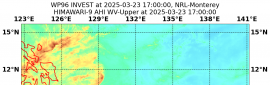
熱帶低氣壓05E(五)警告#01
發佈於24 / 0400Z
TC警告文本
WTPN31 PHNC 240400
MSGID/GENADMIN/JOINT TYPHOON WRNCEN PEARL HARBOR HI//
SUBJ/TROPICAL CYCLONE WARNING//
REF/A/MSG/JOINT TYPHOON WRNCEN PEARL HARBOR HI/231321JUN2018//
APMN/REF A IS A TROPICAL CYCLONE FORMATION ALERT.//
RMKS/
1. TROPICAL DEPRESSION 05E (FIVE) WARNING NR 001
01 ACTIVE TROPICAL CYCLONE IN EASTPAC
MAX SUSTAINED WINDS BASED ON ONE-MINUTE AVERAGE
WIND RADII VALID OVER OPEN WATER ONLY
---
WARNING POSITION:
240000Z --- NEAR 13.9N 115.6W
MOVEMENT PAST SIX HOURS - 355 DEGREES AT 08 KTS
POSITION ACCURATE TO WITHIN 020 NM
POSITION BASED ON CENTER LOCATED BY SATELLITE
PRESENT WIND DISTRIBUTION:
MAX SUSTAINED WINDS - 030 KT, GUSTS 040 KT
WIND RADII VALID OVER OPEN WATER ONLY
REPEAT POSIT: 13.9N 115.6W
---
FORECASTS:
12 HRS, VALID AT:
241200Z --- 15.6N 115.8W
MAX SUSTAINED WINDS - 035 KT, GUSTS 045 KT
WIND RADII VALID OVER OPEN WATER ONLY
RADIUS OF 034 KT WINDS - 030 NM NORTHEAST QUADRANT
030 NM SOUTHEAST QUADRANT
000 NM SOUTHWEST QUADRANT
000 NM NORTHWEST QUADRANT
VECTOR TO 24 HR POSIT: 345 DEG/ 09 KTS
---
24 HRS, VALID AT:
250000Z --- 17.4N 116.3W
MAX SUSTAINED WINDS - 040 KT, GUSTS 050 KT
WIND RADII VALID OVER OPEN WATER ONLY
RADIUS OF 034 KT WINDS - 030 NM NORTHEAST QUADRANT
030 NM SOUTHEAST QUADRANT
020 NM SOUTHWEST QUADRANT
020 NM NORTHWEST QUADRANT
VECTOR TO 36 HR POSIT: 325 DEG/ 08 KTS
---
36 HRS, VALID AT:
251200Z --- 18.7N 117.3W
MAX SUSTAINED WINDS - 040 KT, GUSTS 050 KT
WIND RADII VALID OVER OPEN WATER ONLY
RADIUS OF 034 KT WINDS - 030 NM NORTHEAST QUADRANT
030 NM SOUTHEAST QUADRANT
020 NM SOUTHWEST QUADRANT
020 NM NORTHWEST QUADRANT
VECTOR TO 48 HR POSIT: 310 DEG/ 07 KTS
---
EXTENDED OUTLOOK:
48 HRS, VALID AT:
260000Z --- 19.5N 118.4W
MAX SUSTAINED WINDS - 035 KT, GUSTS 045 KT
WIND RADII VALID OVER OPEN WATER ONLY
RADIUS OF 034 KT WINDS - 030 NM NORTHEAST QUADRANT
020 NM SOUTHEAST QUADRANT
000 NM SOUTHWEST QUADRANT
020 NM NORTHWEST QUADRANT
VECTOR TO 72 HR POSIT: 285 DEG/ 07 KTS
---
72 HRS, VALID AT:
270000Z --- 20.3N 121.3W
MAX SUSTAINED WINDS - 030 KT, GUSTS 040 KT
WIND RADII VALID OVER OPEN WATER ONLY
VECTOR TO 96 HR POSIT: 275 DEG/ 09 KTS
---
LONG RANGE OUTLOOK:
---
96 HRS, VALID AT:
280000Z --- 20.5N 125.0W
MAX SUSTAINED WINDS - 020 KT, GUSTS 030 KT
WIND RADII VALID OVER OPEN WATER ONLY
POST-TROP/REMNT LOW
VECTOR TO 120 HR POSIT: 265 DEG/ 11 KTS
---
120 HRS, VALID AT:
290000Z --- 20.0N 129.5W
MAX SUSTAINED WINDS - 015 KT, GUSTS 025 KT
WIND RADII VALID OVER OPEN WATER ONLY
POST-TROP/REMNT LOW
---
REMARKS:
240400Z POSITION NEAR 14.5N 115.7W.
TROPICAL DEPRESSION 05E (FIVE), LOCATED APPROXIMATELY 1131 NM
SOUTH OF SAN DIEGO, HAS TRACKED NORTHWARD AT 08 KNOTS OVER THE
PAST SIX HOURS. MAXIMUM SIGNIFICANT WAVE HEIGHT AT 240000Z IS 9
FEET. NEXT WARNINGS AT 241000Z, 241600Z, 242200Z AND 250400Z.
2. THIS CANCELS AND SUPERCEDES REF A (WTPN21 PGTW 231330).//
NNNN
|
|


 提升卡
提升卡 千斤頂
千斤頂.png")


.gif")