開啟輔助訪問
 找回密碼
 立即加入

06E.Emilia 整合發展中

簽到天數: 2414 天

[LV.Master]伴壇終老

2018-6-25 23:12 | 顯示全部樓層
  基本資料  
編號    :06 E
擾動編號日期:2018 06 25 23
撤編日期  :2018 06 00 00
96E.INVEST.20kts.1009mb.8N.96W

20180625.0858.f15.goes-15.ir.96E.INVEST.20kts.1009mb.8N.96W.060pc.jpg

NHC : 20%
2. Shower activity associated with a broad low pressure area located
about 500 miles south of eastern Mexico has become a little better
organized during the last 24 hours.  Environmental conditions are
expected to steadily become more conducive for development, and a
tropical depression is likely to form later this week while the
system moves generally westward, well south of the coast of Mexico.
* Formation chance through 48 hours...low...20 percent.
* Formation chance through 5 days...high...80 percent.

two_pac_2d2.png

評分

參與人數 1水氣能量 +15 +1 收起 理由
king111807 + 15 + 1 熱帶擾動首帖

查看全部評分

回復

使用道具 舉報

簽到天數: 601 天

[LV.9]以壇為家II

霧峰追風者|2018-6-26 05:51 | 顯示全部樓層
NHC 展望提升至40%,機構看好發展。
2. Shower activity associated with a broad low pressure area located
about 600 miles south of eastern Mexico has become better organized
during the last 24 hours.   Additional development is forecast, and
a tropical depression is expected to form later this week while the
system moves generally west-northwestward, well south of the coast
of Mexico.
* Formation chance through 48 hours...medium...40 percent.
* Formation chance through 5 days...high...90 percent.
two_pac_2d2.png 20180625.2100.goes-15.ir.96E.INVEST.25kts.1009mb.8.5N.98W.100pc.jpg

回復

使用道具 舉報

簽到天數: 1765 天

[LV.Master]伴壇終老

zjk369|2018-6-26 11:36 | 顯示全部樓層
96E_260200sair.jpg ep9618.gif

熱帶氣旋形成警報WTPN21
於26 / 02ZZ發布
TCFA文本
WTPN21 PHNC 260200
MSGID/GENADMIN/JOINT TYPHOON WRNCEN PEARL HARBOR HI//
SUBJ/TROPICAL CYCLONE FORMATION ALERT//
RMKS/
1. FORMATION OF A SIGNIFICANT TROPICAL CYCLONE IS POSSIBLE WITHIN
180 NM EITHER SIDE OF A LINE FROM 7.9N 95.5W TO 13.2N 103.4W
WITHIN THE NEXT 12 TO 24 HOURS. AVAILABLE DATA DOES NOT JUSTIFY
ISSUANCE OF NUMBERED TROPICAL CYCLONE WARNINGS AT THIS TIME.
WINDS IN THE AREA ARE ESTIMATED TO BE 20 TO 25 KNOTS. METSAT
IMAGERY AT 260130Z INDICATES THAT A CIRCULATION CENTER IS LOCATED
NEAR 8.5N 97.0W. THE SYSTEM IS MOVING WEST-NORTHWESTWARD AT 11
KNOTS.
2. REMARKS: AN AREA OF CONVECTION (INVEST 96E) IS LOCATED NEAR 8.5N
97.0W, APPROXIMATELY 530NM SOUTH-SOUTHEAST OF ACAPULCO, MEXICO.
ANIMATED MULTISPECTRAL SATELLITE IMAGERY AND A 260016Z SSMIS 91GHZ
IMAGE SHOW FORMATIVE BANDING WRAPPING INTO A BROAD LOW LEVEL
CIRCULATION CENTER. UPPER LEVEL ANALYSIS SHOWS A FAVORABLE
ENVIRONMENT WITH GOOD POLEWARD AND EQUATORWARD OUTFLOW AND LOW
VERTICAL WIND SHEAR. DYNAMIC MODELS INDICATE SYSTEM WILL TRACK WEST-
NORTHWESTWARD WITH GRADUAL INTENSIFICATION. MAXIMUM SUSTAINED
SURFACE WINDS ARE ESTIMATED AT 20 TO 25 KNOTS. MINIMUM SEA LEVEL
PRESSURE IS ESTIMATED TO BE NEAR 1006 MB. THE POTENTIAL FOR THE
DEVELOPMENT OF A SIGNIFICANT TROPICAL CYCLONE WITHIN THE NEXT 24
HOURS IS HIGH.
3. THIS ALERT WILL BE REISSUED, UPGRADED TO WARNING OR CANCELLED
BY 270200Z.//NNNN
回復

使用道具 舉報

簽到天數: 601 天

[LV.9]以壇為家II

霧峰追風者|2018-6-26 15:19 | 顯示全部樓層
NHC 展望提升至70%
1. Shower and thunderstorm activity associated with a broad low
pressure area located about 600 miles south of Acapulco,Mexico, has
changed little over the past several hours.  However, environmental
conditions are expected to gradually become more conducive for
development, and a tropical depression is expected to form within
the next couple of days while the system moves generally
west-northwestward, well south of the coast of Mexico.
* Formation chance through 48 hours...high...70 percent.
* Formation chance through 5 days...high...90 percent.
two_pac_2d1 (8).png 20180626.0600.goes-15.ircolor.96E.INVEST.25kts.1008mb.8.5N.97W.100pc.jpg

回復

使用道具 舉報

簽到天數: 601 天

[LV.9]以壇為家II

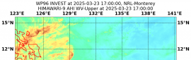
霧峰追風者|2018-6-28 05:28 | 顯示全部樓層
NHC 18Z升格"熱帶低壓06E",巔峰暫時上望50KT。
000
WTPZ41 KNHC 272034
TCDEP1

Tropical Depression Six-E Discussion Number   1
NWS National Hurricane Center Miami FL       EP062018
300 PM MDT Wed Jun 27 2018

Satellite images indicate that the low pressure area south of
Manzanillo has become better defined during the day, with ample
banding features to the north and west of the center.  Thus, this
system is declared a tropical depression, and the initial wind speed
is set to 30 kt, which is based on an overnight scatterometer
pass and a satellite estimate of 30 kt from TAFB.

The center has not been particularly easy to track since it hasn't
had a lot of continuity.  Generally the overall system has been
moving west-northwestward at about 13 kt, so that will be the
initial motion.  A mid-level ridge over Mexico extending westward
into the eastern Pacific is expected to steer the depression
generally west-northwestward for the next several days, with some
gradual decrease in forward speed in a few days due to the ridge
weakening. The biggest uncertainty in the model guidance appears to
be in the shorter term, with several models indicating a
northwestward motion could begin soon.  That motion doesn't make
sense with the west-to-east orientation of the ridge, so the
official forecast is on the southern side of the guidance envelope
and the model consensus.

Moderate northeasterly shear is forecast to wane over the next few
days, which should promote strengthening since the depression is
over warm waters.  However, this intensification could be tempered
by marginal SSTs in 2 or 3 days, and an intrusion of drier mid-level
air as suggested by the GFS/ECMWF models.  Thus only a moderate
amount of strengthening is forecast, and the official forecast is
between the SHIPS model and the NOAA corrected consensus HCCA model.
In about 4 days, the depression will likely be over rather marginal
SSTs with nearby dry air.  These conditions will probably kill off
any remaining deep convection, causing the cyclone to degenerate
into a remnant low by day 5.


FORECAST POSITIONS AND MAX WINDS

INIT  27/2100Z 13.3N 108.5W   30 KT  35 MPH
12H  28/0600Z 14.1N 110.2W   30 KT  35 MPH
24H  28/1800Z 15.1N 112.4W   35 KT  40 MPH
36H  29/0600Z 16.0N 114.4W   40 KT  45 MPH
48H  29/1800Z 16.6N 116.1W   45 KT  50 MPH
72H  30/1800Z 17.5N 119.0W   50 KT  60 MPH
96H  01/1800Z 18.5N 122.5W   40 KT  45 MPH
120H  02/1800Z 19.5N 126.5W   30 KT  35 MPH...POST-TROP/REMNT LOW

$$
203558_5day_cone_no_line_and_wind.png avn-animated.gif

回復

使用道具 舉報

簽到天數: 601 天

[LV.9]以壇為家II

霧峰追風者|2018-6-28 16:52 | 顯示全部樓層
NHC 命名"Emilia",也是六月份第5個命名熱帶系統。
083339_5day_cone_no_line_and_wind.png avn-animated (5).gif

回復

使用道具 舉報

快速回覆
您需要登錄後才可以回帖 登錄 | 立即加入

本版積分規則

0908morakot

    主題

    帖子

    69萬

    積分

    12級[颶風Hurricane]

    Rank: 12Rank: 12Rank: 12

12級[颶風Hurricane]

發訊息

本平台僅供學術討論之用,預報應以氣象局為準

威普網站虛擬主機贊助公司

臺灣第一個天氣類型社群平台 即時天氣資訊、精準颱風動態

線上客服
FB傳送訊息
廣告行銷
精準行銷 物超所值
官方粉專
發佈 快速回復 返回頂部 返回列表