開啟輔助訪問
 找回密碼
 立即加入

03L.Chris 底層建立風眼開啟 沿美東外海北上轉化溫氣

簽到天數: 601 天

[LV.9]以壇為家II

2018-7-6 00:02 | 顯示全部樓層
本帖最後由 霧峰追風者 於 2018-9-26 03:51 編輯

  二級颶風  
編號:03 L
名稱:Chris
800px-Chris_2018-07-10_1815Z.jpg
  基本資料  
擾動編號日期:2018 07 05 23
命名日期  :2018 07 08 17
撤編日期  :2018 07 12 23
登陸地點  :

  巔峰時期資料  
近中心最強風速
國家颶風中心(NHC):90 kts
海平面最低氣壓970 百帕

  過去路徑圖  
1920px-Chris_2018_track.png
  擾動編號資料  
96L.INVEST.15kts-1008mb-30.0N-70.0W

20180705.1500.msg-4.ir.96L.INVEST.15kts.1008mb.30N.70W.080pc.jpg

評分

參與人數 1水氣能量 +15 +1 收起 理由
t02436 + 15 + 1

查看全部評分

回復

使用道具 舉報

簽到天數: 601 天

[LV.9]以壇為家II

霧峰追風者|2018-7-7 04:33 | 顯示全部樓層
NHC 展望提升至70%
1. Showers and thunderstorms associated with a well-defined but
still weak low pressure system located a few hundred miles
southeast of the North Carolina coast are gradually becoming better
organized, although surface pressures in the area remain high.
Environmental conditions are expected to be conducive for additional
development of this system, and a tropical depression is likely to
form over the next couple of days while it moves slowly
northwestward and stalls or meanders near the coast of North
Carolina over the weekend.  Interests along the North Carolina and
South Carolina coasts should monitor the progress of this system
during the next several days.
* Formation chance through 48 hours...high...70 percent.
* Formation chance through 5 days...high...80 percent.
two_atl_2d1.png 96L_gefs_latest.png

回復

使用道具 舉報

簽到天數: 601 天

[LV.9]以壇為家II

霧峰追風者|2018-7-7 05:04 | 顯示全部樓層
NHC 升格熱帶低壓03L,美東近岸徘徊,巔峰上望70KT。
000
WTNT43 KNHC 062039
TCDAT3

Tropical Depression Three Discussion Number   1
NWS National Hurricane Center Miami FL       AL032018
500 PM EDT Fri Jul 06 2018

The area of low pressure located a few hundred miles southeast of
the North Carolina coast has developed enough deep convection
with a well-defined circulation to be classified as a tropical
depression.  This is supported by a Dvorak T-number of 2.0 from
TAFB, and an earlier ASCAT pass with 25-kt winds, which is the
initial intensity assigned to the depression.  Given that the system
is moving over warm waters and in a low-shear environment, gradual
strengthening is indicated, and the NHC forecast shows the
depression becoming a tropical storm on Saturday.  Additional
intensification could occur by the end of the forecast period when
the cyclone moves northeastward away from the U.S coast and
interacts with a mid-level trough. The intensity forecast is very
close to the SHIPS model and the Corrected Consensus HCCA.

The depression is moving toward the north-northwest or 335 degrees
at about 4 knots. The tropical cyclone is currently located on the
southwestern edge of the subtropical ridge, and this weak flow
pattern should keep the depression on the same slow track for the
next 24 hours or so.  After that time, the steering currents are
expected to collapse, and the cyclone should begin to meander for a
couple of days well off the coast of North Carolina.  Then a
mid-level trough is expected to approach from the west and force
the system on a northeastward track.

Most of the guidance suggests that the tropical-storm-force winds
associated with the cyclone will occur in the eastern quadrant
well away from the U.S. coast.  On this basis, no watches or
warnings are required for the U.S coast at this time, however,
interests along the North Carolina coast should monitor the
progress of this system.

Due to a technical issue, the wind speed probability values at land
locations in the wind speed probability text product are too high
and do not reflect reduced probabilities that are expected over
land.  The wind speed probability values provided in the graphics
on the NHC website at hurricanes.gov, and in the publicly
disseminated grid files do correctly reflect the reduced
probabilities over land.  As a result, users should refer to the NHC
website graphics and gridded products instead of the text product
for the most accurate wind speed probability values until this
problem is resolved.

FORECAST POSITIONS AND MAX WINDS

INIT  06/2100Z 32.2N  73.8W   25 KT  30 MPH
12H  07/0600Z 32.9N  74.3W   30 KT  35 MPH
24H  07/1800Z 33.7N  74.5W   35 KT  40 MPH
36H  08/0600Z 34.0N  74.3W   40 KT  45 MPH
48H  08/1800Z 34.0N  74.0W   45 KT  50 MPH
72H  09/1800Z 33.5N  73.7W   50 KT  60 MPH
96H  10/1800Z 33.5N  73.7W   65 KT  75 MPH
120H  11/1800Z 36.5N  69.5W   70 KT  80 MPH

$$
Forecaster Avila
204123_5day_cone_no_line_and_wind.png 20180706.1826.f15.ir.olsircomp.96L.INVEST.x.jpg

回復

使用道具 舉報

簽到天數: 601 天

[LV.9]以壇為家II

霧峰追風者|2018-7-8 19:13 | 顯示全部樓層
NHC 稍早命名"Chris",巔峰上望一級颶風,逐漸北上。
000
WTNT43 KNHC 080858
TCDAT3

Tropical Storm Chris Discussion Number   7
NWS National Hurricane Center Miami FL       AL032018
500 AM EDT Sun Jul 08 2018

An Air Force Reserve reconnaissance aircraft has been investigating
the cyclone early this morning, and found flight-level winds of 45
kt at 925 mb and believable SFMR surface winds of around 34
kt in the southeast quadrant.  On this basis, the system has been
designated as Tropical Storm Chris, the 3rd named storm of the 2018
Atlantic season.

Although the winds associated with the tropical storm have increased
a little, the overall organization of Chris has not changed much
over the past few hours.  The low-level center is still exposed to
the north of a broken band of deep convection and the cyclone lacks
an inner-core.  Chris is located over very warm SSTs and will
remain so for the next several days.  While the broad nature of the
cyclone's circulation and some moderate shear will likely limit the
intensification rate over the next day or so, all of the intensity
guidance indicates that Chris will become a hurricane within about
72-h.  By day 4, the intensity forecast is more uncertain,
and depends strongly on the timing of Chris crossing the Gulf
Stream, since the cyclone is expected to continue to intensify as
long as it remains over warm waters.  Once extratropical transition
begins, weakening should occur as the wind field broadens.  The new
intensity forecast is close to HCCA and IVCN through day 3, and
slightly lower beyond that, closer to the previous forecast.

The track guidance has once again made a large shift with the latest
forecast cycle.  While Chris is generally expected to continue to
meander off the coast of the Carolinas for the next couple of days
before accelerating to the northeast ahead of a deep-layer trough
approaching from the northwest, the timing of this acceleration is
highly uncertain.  Nearly all of the dynamical models have now
shifted to the south and west of their previous forecasts throughout
most of the forecast period.  The NHC track forecast has been
adjusted in that direction, but now lies on the eastern side of the
guidance envelope, and shows a faster motion than most of the
models.  Given the large run-to-run inconsistency of the guidance
over the past 24 hours, I would prefer to wait to make a more
significant change to the forecast until a more clear pattern
emerges.

The Air Force reconnaissance plane also measured winds to
gale-force about 20 miles off the coast of North Carolina.  These
winds are associated with the tight pressure gradient between
Chris and high pressure over the northeastern U.S.  See products
issued by the National Weather Service forecast offices for more
details.


FORECAST POSITIONS AND MAX WINDS

INIT  08/0900Z 33.0N  75.5W   35 KT  40 MPH
12H  08/1800Z 33.0N  75.4W   40 KT  45 MPH
24H  09/0600Z 32.8N  75.3W   45 KT  50 MPH
36H  09/1800Z 32.6N  75.1W   55 KT  65 MPH
48H  10/0600Z 32.7N  74.7W   60 KT  70 MPH
72H  11/0600Z 35.2N  71.5W   70 KT  80 MPH
96H  12/0600Z 41.5N  64.0W   70 KT  80 MPH
120H  13/0600Z 49.0N  54.5W   55 KT  65 MPH...POST-TROP/EXTRATROP

$$
Forecaster Zelinsky
090009_5day_cone_no_line_and_wind.png 20180708.072500.aqua.modis.Infrared.tc1803LTHREE.covg89p1.modislance.res1km.jpg

回復

使用道具 舉報

簽到天數: 3291 天

[LV.Master]伴壇終老

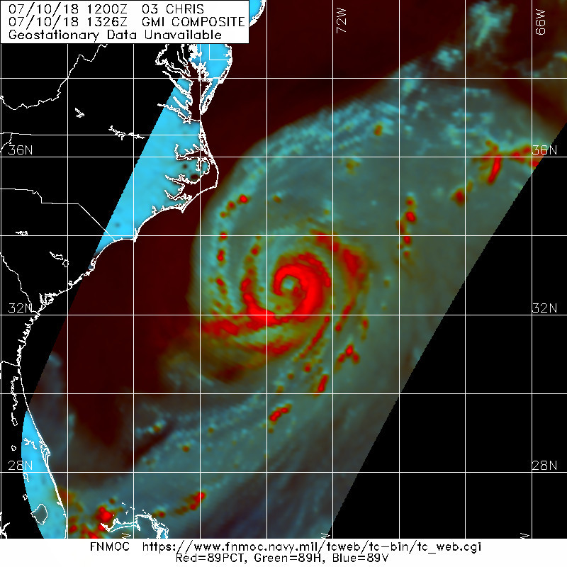
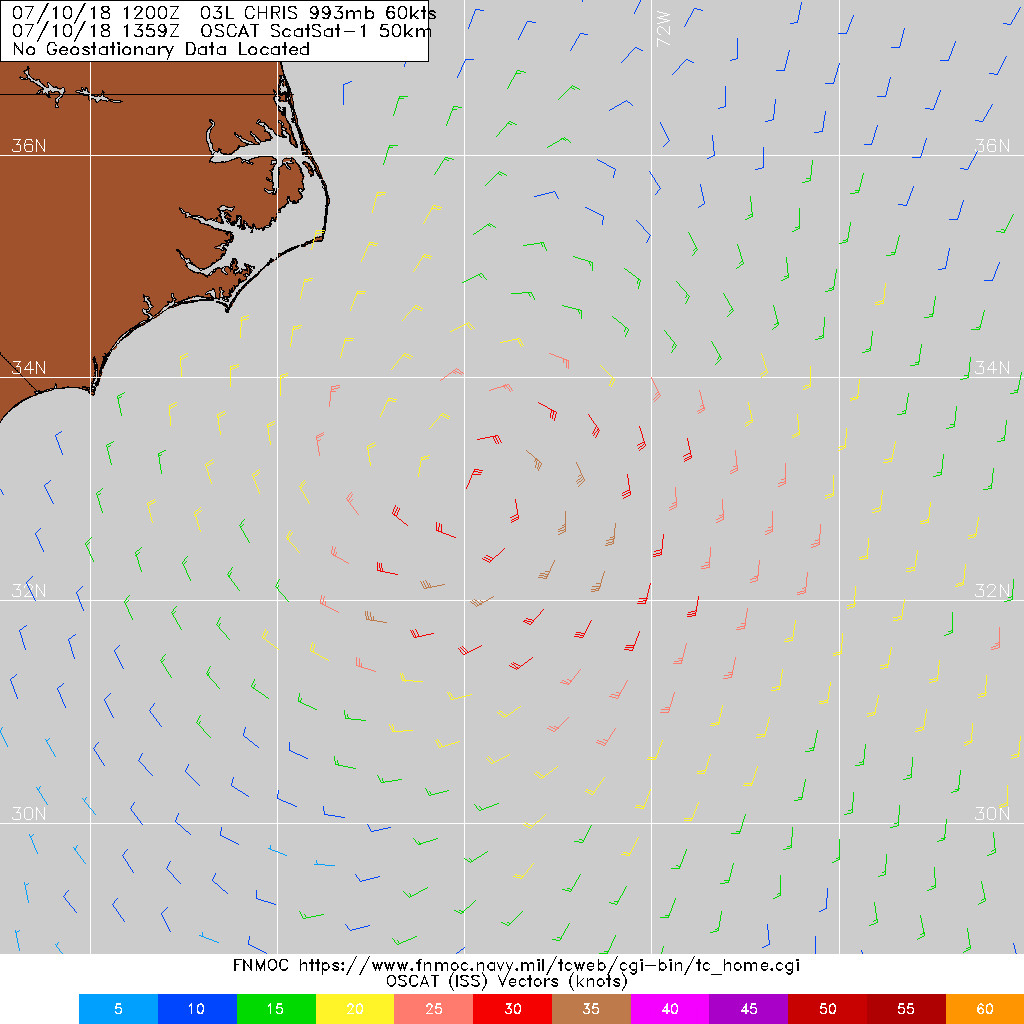
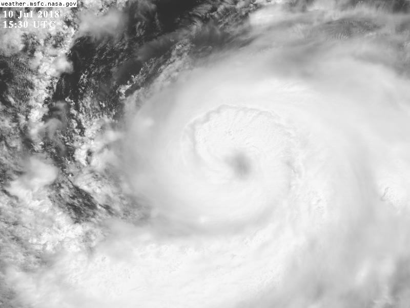
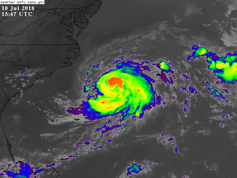
t02436|2018-7-11 00:13 | 顯示全部樓層
底層就緒,高層開眼中,00Z以前就會站上C1,5天之後以溫帶氣旋性質影響英國。
034
WTNT43 KNHC 101452
TCDAT3

Tropical Storm Chris Discussion Number  16
NWS National Hurricane Center Miami FL       AL032018
1100 AM EDT Tue Jul 10 2018

During the past 6 hours, Chris has developed a well-defined eye in
both satellite and radar imagery at times, with a diameter that has
varied in size from 30 nmi to the present 20 nmi. The overall
convective pattern has also become more symmetrical with
well-established outflow present in all quadrants. Satellite
intensity estimates are T3.5/55 kt from TAFB, and T4.0/65 kt from
SAB and UW-CIMSS ADT, and Chris certainly has the satellite
appearance of being a hurricane. However, the intensity is being
maintained at 60 kt for this advisory due to significant cold
upwelling that has occurred beneath the cyclone when Chris was
moving slowly during the previous 48 hours. The colder waters have
likely stabilized the boundary layer, which has inhibited stronger
winds aloft from mixing down to the surface. The cold upwelling is
supported by sea-surface temperature (SST) data from nearby NOAA
Buoy 41002, which has shown 6 deg F of cooling during the past 48
hours, and is currently sitting at 76F. An Air Force Reserve
reconnaissance aircraft is scheduled to investigate Chris this
afternoon to provide a better intensity estimate.

Recent satellite and radar fixes indicate that Chris is finally
moving northeastward at a faster forward speed, and the initial
motion estimate is now 050/08 kt. The narrow subtropical ridge to
the southeast of the cyclone is getting pushed northward by the
remnants of Beryl, which has helped to finally nudge Chris toward
the northeast. A further increase in forward speed is expected as a
strong deep-layer trough digs southeastward along the U.S. east
coast, accelerating the cyclone at forward speeds of 25-30 kt by 48
hours and beyond. Chris is forecast to pass well southeast of Nova
Scotia in a couple of days, and move near or over southeastern
Newfoundland in about 60 hours. The NHC track guidance remains in
good agreement on the evolving steering flow regime, but there
continues to be some pronounced speed differences. The new NHC track
forecast is similar to the previous advisory, and lies close to the
consensus models HCCA, FSSE, and TVCN.

My best estimate, based on the data from Buoy 41002, is that
significant upwelling likely occurred within the 30-kt wind radii
while Chris was nearly stationary. Assuming that that is the case,
then Chris will be moving over warmer waters shortly, which should
allow for an increase in convection to occur and also for winds
aloft to better mix downward to the surface. The vertical wind shear
is forecast to remain modest at 10-15 kt for the next 24 hours, so
gradual intensification is expected during that time. By 48 hours,
Chris will have crossed over the north wall of the Gulfstream and be
moving over SSTs colder than 20 deg C, which will combine with
strong southwesterly wind shear, and cause Chris to rapidly
transition to an extratropical cyclone. The official intensity
forecast follows the FSSE intensity model through 36 hours, and then
shows more significant weakening after that, similar to the SHIPS,
LGEM, and HCCA models.

FORECAST POSITIONS AND MAX WINDS

INIT  10/1500Z 33.1N  73.1W   60 KT  70 MPH
12H  11/0000Z 33.9N  71.9W   70 KT  80 MPH
24H  11/1200Z 35.6N  69.4W   75 KT  85 MPH
36H  12/0000Z 38.4N  65.5W   75 KT  85 MPH
48H  12/1200Z 42.0N  60.6W   65 KT  75 MPH
72H  13/1200Z 48.1N  49.3W   50 KT  60 MPH...POST-TROP/EXTRATROP
96H  14/1200Z 52.0N  31.9W   35 KT  40 MPH...POST-TROP/EXTRATROP
120H  15/1200Z 54.0N  18.0W   35 KT  40 MPH...POST-TROP/EXTRATROP

$$
Forecaster Stewart
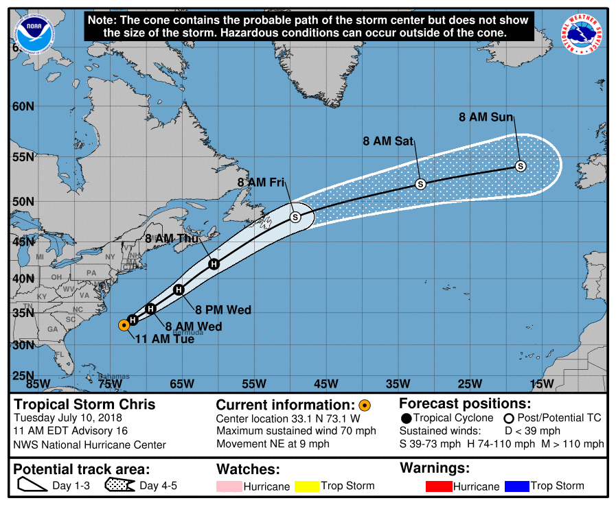
145514_5day_cone_with_line.png

20180710.1326.gpm.89pct89h89v.03L.CHRIS.60kts.993mb.32.8N.73.5W.065pc.jpg

LATEST.jpg

GOES153020181912kY7B7.jpg

GOES15472018191VkDdtY.jpg
回復

使用道具 舉報

簽到天數: 601 天

[LV.9]以壇為家II

霧峰追風者|2018-7-11 13:07 | 顯示全部樓層
本帖最後由 霧峰追風者 於 2018-7-11 13:25 編輯

風眼開啟,強度升二級颶風。
001
WTNT43 KNHC 110244
TCDAT3

Hurricane Chris Discussion Number  18
NWS National Hurricane Center Miami FL       AL032018
1100 PM EDT Tue Jul 10 2018

Chris has been rapidly intensifying since the center moved out of
the area of upwelled cold water about 18 h ago, likely due to an
inner core convective ring seen earlier in microwave imagery
becoming a fully-developed eyewall as the cyclone encountered warmer
water.  Satellite intensity estimates from SAB and TAFB at 00Z were
90 kt and 77 kt, and the CIMSS SATCON technique estimate was 90 kt.
Based on this and a subsequent increase in organization, the initial
intensity is increased to a possibly conservative 90 kt.

The initial motion remains 050/9.  Chris is becoming embedded in
the mid-latitude westerlies between the subtropical ridge to the
southeast and a large deep-layer trough over eastern Canada and the
northeastern United states.  The combination of these features
should cause Chris to accelerate northeastward into the North
Atlantic through 96 h, passing near southeastern Newfoundland in
about 48 h. The new forecast track is a blend of the previous track
and the HCCA and TVCN consensus models, and it is a little faster
than the previous forecast.

The eye of Chris is about to move over an area of slightly cooler
water south of the core of the Gulf Stream, and this will likely
slow the intensification rate.  Otherwise, conditions appear
favorable for intensification for the next 18-24 h, and the
intensity forecast shows a little more strengthening before Chris
moves north of the Gulf Stream.  Extratropical transition should
begin after Chris moves north of the Gulf Stream and be complete
before the cyclone passes near southeastern Newfoundland.  After
that, the extratropical low should gradually decay as it crosses
the North Atlantic.  The new intensity forecast is increased from
the previous forecast for the first 36 h based on current trends,
and it has been lowered from the previous forecast between 72-120 h
based on the latest guidance.


FORECAST POSITIONS AND MAX WINDS

INIT  11/0300Z 34.2N  71.4W   90 KT 105 MPH
12H  11/1200Z 35.8N  69.1W   95 KT 110 MPH
24H  12/0000Z 38.8N  64.8W   95 KT 110 MPH
36H  12/1200Z 42.8N  59.4W   80 KT  90 MPH
48H  13/0000Z 46.6N  53.1W   60 KT  70 MPH...POST-TROP/EXTRATROP
72H  14/0000Z 53.0N  36.0W   45 KT  50 MPH...POST-TROP/EXTRATROP
96H  15/0000Z 57.0N  19.0W   40 KT  45 MPH...POST-TROP/EXTRATROP
120H  16/0000Z 61.5N  10.0W   40 KT  45 MPH...POST-TROP/EXTRATROP

$$
Forecaster Beven
024624_5day_cone_no_line_and_wind.png 20180710.2250.f18.ir.olsircomp.03L.CHRIS.x.jpg goes16_vis_03L_201807101251.jpg goes16_vis-swir_03L_201807110206.jpg
回復

使用道具 舉報

快速回覆
您需要登錄後才可以回帖 登錄 | 立即加入

本版積分規則

本平台僅供學術討論之用,預報應以氣象局為準

威普網站虛擬主機贊助公司

臺灣第一個天氣類型社群平台 即時天氣資訊、精準颱風動態

線上客服
FB傳送訊息
廣告行銷
精準行銷 物超所值
官方粉專
發佈 快速回復 返回頂部 返回列表