開啟輔助訪問
 找回密碼
 立即加入

12E.John 風眼開啟 將達顛峰

簽到天數: 2414 天

[LV.Master]伴壇終老

2018-8-4 14:06 | 顯示全部樓層
  二級颶風  
編號:12 E
名稱:John

  基本資料  
擾動編號日期:2018 08 04 13
升格熱低日期:2018 08 06 05
命名日期  :2018 08 06 11
撤編日期  :2018 08 00 00
登陸地點  :暫無

  巔峰時期資料  
近中心最強風速 :90 kt
海平面最低氣壓 :969 百帕

  過去路徑圖  

  討論帖圖片  
95E.INVEST.25kts.1009mb.10.5N.101.2W

20180804.0600.goes-15.ircolor.95E.INVEST.25kts.1009mb.10.5N.101.2W.100pc.jpg

以上資料來自:NHC、颱風論壇整理製作

評分

參與人數 1水氣能量 +15 +1 收起 理由
t02436 + 15 + 1

查看全部評分

回復

使用道具 舉報

簽到天數: 601 天

[LV.9]以壇為家II

霧峰追風者|2018-8-4 14:12 | 顯示全部樓層
本帖最後由 霧峰追風者 於 2018-8-4 14:19 編輯

NHC 展望提升至70%,看好發展。
2. A large area of disturbed weather centered several hundred miles
southwest of the Gulf of Tehuantepec continues to show signs of
becoming better organized.  Environmental conditions appear
conducive for development and a tropical depression or tropical
storm is expected form within the next few days while the system
moves west-northwestward off the coast of Mexico.
* Formation chance through 48 hours...high...70 percent.
* Formation chance through 5 days...high...90 percent.
two_pac_2d2.png
回復

使用道具 舉報

簽到天數: 2141 天

[LV.Master]伴壇終老

周子堯@FB|2018-8-4 17:58 | 顯示全部樓層
TCFA!

2. REMARKS:
AN AREA OF CONVECTION (INVEST 95E) HAS PERSISTED NEAR 10.5N 101.2W
APPROXIMATELY 390NM SOUTH-SOUTHWEST OF ACAPULCO, MEXICO. ANIMATED
ENHANCED INFRARED IMAGERY DEPICTS DISORGANIZED, FLARING CONVECTION
REVOLVING OVER A LOW LEVEL CIRCULATION CENTER. THE ENVIRONMENT IS
OVERALL FAVORABLE, WITH WARM (28-29C) SSTS AND LOW (5-10KTS)
VERTICAL WIND SHEAR. GLOBAL MODELS GENERALLY SHOW THAT 95E WILL
TRACK WEST-NORTHWESTWARD ALONG THE COAST OF MEXICO OVER THE NEXT FEW
DAYS AS IT GAINS IN INTENSITY, POSSIBLY INTERACTING WITH 94E IN THE
LATE TERM. MAXIMUM SUSTAINED SURFACE WINDS ARE ESTIMATED AT 25 TO 30
KNOTS. MINIMUM SEA LEVEL PRESSURE IS ESTIMATED TO BE NEAR 1000 MB.
THE POTENTIAL FOR THE DEVELOPMENT OF A SIGNIFICANT TROPICAL CYCLONE
WITHIN THE NEXT 24 HOURS IS HIGH.


回復

使用道具 舉報

簽到天數: 601 天

[LV.9]以壇為家II

霧峰追風者|2018-8-6 05:01 | 顯示全部樓層
NHC 升格熱帶低壓12E,巔峰暫時上望90KT。

360
WTPZ42 KNHC 052039
TCDEP2

Tropical Depression Twelve-E Discussion Number   1
NWS National Hurricane Center Miami FL       EP122018
400 PM CDT Sun Aug 05 2018

The low pressure area located a few hundred miles south of the
southwest coast of Mexico has become better defined today and the
associated deep convection has enough organization to classify the
system as a tropical depression, the twelfth tropical cyclone of the
2018 eastern Pacific hurricane season.  The initial intensity is
set at 30 kt, which is in agreement with Dvorak satellite intensity
estimates from both TAFB and SAB.

The initial motion estimate is northwestward at about 6 kt.  The
track and intensity forecast for the depression is complicated due
to the close proximity of Tropical Storm Ileana to its
east-southeast.  Somewhat surprisingly, however, the track guidance
is in relatively good agreement on a general northwestward motion
around the western portion of a mid-level ridge over northern
Mexico during the next several days.  Since the depression is larger
than Ileana, most of the global models suggest that Ileana will move
around the northeastern portion of the new tropical cyclone's
circulation and weaken and dissipate.  The NHC track forecast is
near the middle of the guidance envelope between the slower ECMWF
solution, and the faster GFS, HWRF, and HMON tracks.

The depression is currently over very warm SSTs, within low shear,
and a moist atmosphere.  These factors suggest that the depression
will steadily strengthen and the intensity guidance is quite
aggressive in intensifying the system.  The NHC forecast is slightly
more conservative during the first 36 h since the system is still
quite broad and lacks an inner core.  Regardless, the NHC forecast
brings the system to hurricane strength within 36 h, and shows a
peak intensity of 90 kt in 3 days, which is in agreement with the
HFIP corrected consensus model.  Cool waters and less favorable
thermodynamic conditions should lead to steady to rapid weakening
late in the forecast period.


FORECAST POSITIONS AND MAX WINDS

INIT  05/2100Z 14.6N 105.8W   30 KT  35 MPH
12H  06/0600Z 15.2N 106.5W   40 KT  45 MPH
24H  06/1800Z 16.0N 107.4W   50 KT  60 MPH
36H  07/0600Z 16.9N 108.3W   65 KT  75 MPH
48H  07/1800Z 17.9N 109.6W   75 KT  85 MPH
72H  08/1800Z 20.5N 112.8W   90 KT 105 MPH
96H  09/1800Z 23.2N 117.0W   65 KT  75 MPH
120H  10/1800Z 25.5N 121.5W   45 KT  50 MPH

$$
Forecaster Brown
204038_5day_cone_no_line_and_wind.png 20180805.1401.f17.ir.olsircomp.95E.INVEST.x.jpg

回復

使用道具 舉報

簽到天數: 3291 天

[LV.Master]伴壇終老

t02436|2018-8-6 11:18 | 顯示全部樓層
命名John,上望95節。
792
WTPZ42 KNHC 060250
TCDEP2

Tropical Storm John Discussion Number   2
NWS National Hurricane Center Miami FL       EP122018
900 PM MDT Sun Aug 05 2018

Convection associated with Tropical Depression Twelve-E has
continued to become better organized, although recent microwave
satellite data suggest the low-level center is elongated from
northwest to southeast.  Satellite intensity estimates from TAFB and
SAB have increased to 35 kt, and based on these the depression is
upgraded to Tropical Storm John.

The initial motion is 315/7.  A westward-moving mid- to upper-level
trough over northern Mexico has weakened the subtropical ridge over
the northeastern Pacific, and the large-scale models are in good
agreement that John will move northwestward at an increasing
forward speed toward this weakness.  A complicating factor is that
John may interact with Tropical Storm Ileana to the east.  However,
John is much larger than Ileana, and the most likely impact of this
interaction is that John could move a little slower than currently
forecast.  The new forecast track is a little to the north of the
previous track after 48 h, but is otherwise similar to the previous
forecast.  The new track also lies just south of the cluster of
consensus models.

John is expected to be in an environment of very warm SSTs, low
shear, and a moist atmosphere through about 60 h.  This environment
is quite favorable for rapid intensification (RI), as indicated by
high probabilities in the SHIPS RI index, and it is likely that RI
will begin as soon as the inner core of the storm becomes better
organized.  The NHC forecast calls for the storm to become a
hurricane in 24-36 h and to reach a peak intensity of 95 kt in about
three days.  After that, the forecast track takes John over rapidly
cooling sea surface temperatures, which should cause at least a
steady weakening.  The intensity forecast is in best agreement with
the intensity consensus.  It should be noted, however, that the
SHIPS and LGEM models both show more intensification than the
official forecast and make John a major hurricane in about three
days.


FORECAST POSITIONS AND MAX WINDS

INIT  06/0300Z 14.9N 106.2W   35 KT  40 MPH
12H  06/1200Z 15.6N 107.0W   45 KT  50 MPH
24H  07/0000Z 16.3N 107.9W   60 KT  70 MPH
36H  07/1200Z 17.3N 108.9W   75 KT  85 MPH
48H  08/0000Z 18.5N 110.3W   90 KT 105 MPH
72H  09/0000Z 21.5N 113.5W   95 KT 110 MPH
96H  10/0000Z 24.0N 118.0W   65 KT  75 MPH
120H  11/0000Z 26.0N 122.0W   40 KT  45 MPH

$$
Forecaster Beven
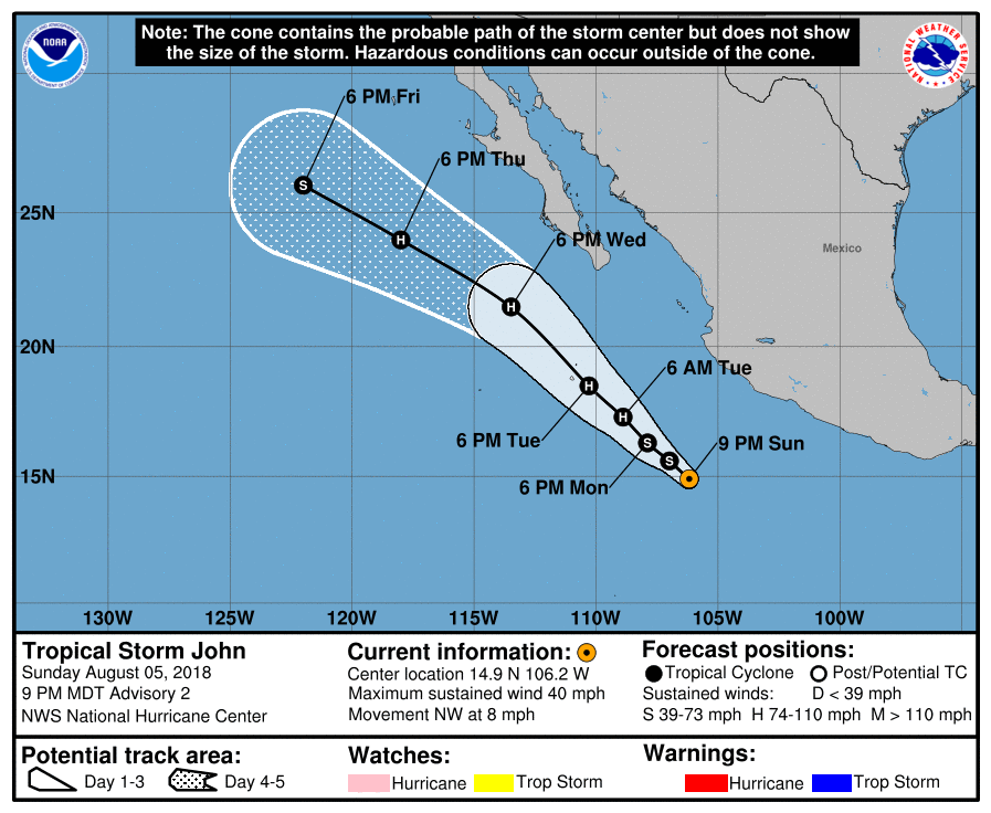
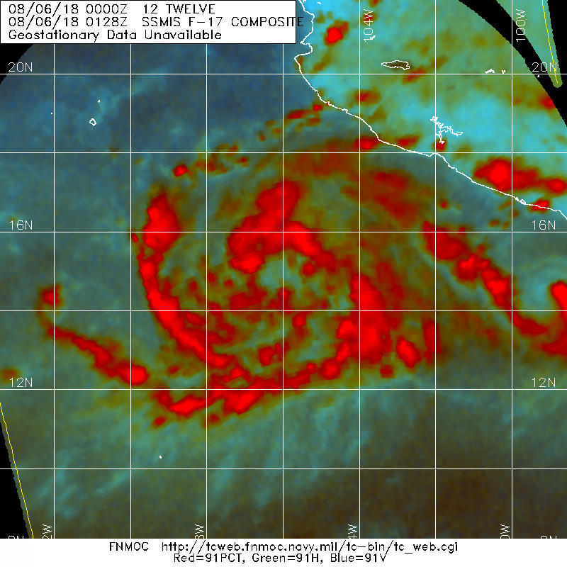
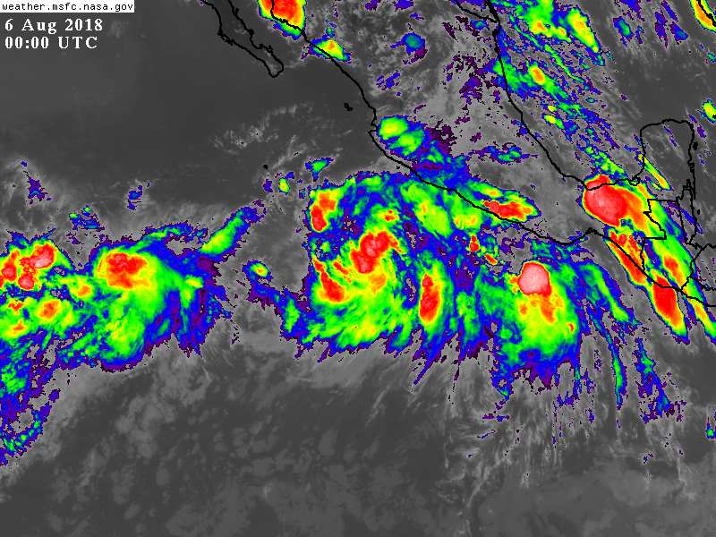
025245_5day_cone_with_line.png

20180806.0128.f17.91pct91h91v.12E.TWELVE.35kts.1004mb.14.7N.106W.100pc.jpg

GOES00002018218rSSaxN.jpg
回復

使用道具 舉報

簽到天數: 601 天

[LV.9]以壇為家II

霧峰追風者|2018-8-7 08:24 | 顯示全部樓層
風眼隱現,NHC 21Z強度升一級颶風,巔峰上望110KT。
038
WTPZ42 KNHC 062048
TCDEP2

Hurricane John Discussion Number   5
NWS National Hurricane Center Miami FL       EP122018
300 PM MDT Mon Aug 06 2018

John has continued to intensify since the previous advisory.
Visible satellite images continue to indicate an increase in
banding and very recent pictures show the formation of a banding
eye.  As a result, the initial intensity is increased to 65 kt,
which is based on a TAFB Dvorak T-number of 4.0 and UW/CIMSS
objective Dvorak estimates that are close to 65 kt.  John becomes
the fifth hurricane of the 2018 eastern North Pacific hurricane
season.

John is forecast to remain within a very favorable environment for
strengthening during the next day or so.  Although some of the
intensity guidance is not quite as aggressive as this morning, the
various rapid intensification indices still show a high likelihood
of rapid strengthening during the next 24 hours.  The NHC forecast
once again calls for rapid intensification and brings John to major
hurricane strength within 36 h. The updated NHC intensity forecast
is near the upper-end of the guidance in best agreement with the
latest SHIPS, HCCA, and FSSE models.  After 48 h, John will be
moving over much cooler waters and into a less conducive
thermodynamic environment.  This should result in rapid weakening,
and John is forecast to become a remnant low by day 5.

John is moving northwestward at about 7 kt.  The hurricane is
forecast to move northwestward around the western periphery of a
mid-level ridge over northern Mexico during the next few days.  Once
the system weakens and becomes a more shallow cyclone late in the
forecast period, it should turn westward in the low-level flow.
The overall track envelope has shifted eastward this cycle, with
the GFS and HWRF along the eastern edge of the track guidance
envelope while the ECMWF and UKMET are along the western side.
The new NHC forecast has been adjusted eastward and lies between
the ECMWF and the various consensus aids.

Due to the eastward shift in the forecast track and the predicted
increase in the size of John, interests in the southern portion of
the Baja California peninsula should monitor the progress of this
system.

FORECAST POSITIONS AND MAX WINDS

INIT  06/2100Z 16.0N 108.0W   65 KT  75 MPH
12H  07/0600Z 16.8N 108.7W   80 KT  90 MPH
24H  07/1800Z 18.1N 109.9W   95 KT 110 MPH
36H  08/0600Z 19.6N 111.3W  110 KT 125 MPH
48H  08/1800Z 21.0N 112.8W  105 KT 120 MPH
72H  09/1800Z 24.3N 117.0W   70 KT  80 MPH
96H  10/1800Z 26.6N 121.2W   45 KT  50 MPH
120H  11/1800Z 27.2N 124.8W   30 KT  35 MPH...POST-TROP/REMNT LOW

$$
Forecaster Brown
212725_5day_cone_no_line_and_wind.png avn-animated.gif

點評

甜心 夏威夷?沒這趨勢...  發表於 2018-8-7 17:48
未來路徑看起來怎麼好像會朝美國的夏威夷群島撲去...。  發表於 2018-8-7 13:31
回復

使用道具 舉報

簽到天數: 2141 天

[LV.Master]伴壇終老

周子堯@FB|2018-8-7 17:51 | 顯示全部樓層
逐漸吸收11E
20180807.0930.goes-15.ir.11E.ILEANA.45kts.1002mb.19N.106W.100pc.jpg
EP112018_5day_cone_no_line.png


回復

使用道具 舉報

簽到天數: 3291 天

[LV.Master]伴壇終老

t02436|2018-8-7 23:21 | 顯示全部樓層
吞了Ileana,15Z評價90節,明天到巔峰。
784
WTPZ42 KNHC 071447
TCDEP2

Hurricane John Discussion Number   8
NWS National Hurricane Center Miami FL       EP122018
900 AM MDT Tue Aug 07 2018

Visible and infrared satellite images have continued to show the
ragged eye of John this morning, but the surrounding convective
cloud tops have become more symmetric and cooled since the previous
advisory.  The latest Dvorak satellite intensity estimates from
TAFB and SAB were T5.0/90 kt, which support increasing the initial
wind speed to that value.  John has about another 24 hours over
warm water in which to intensify, and the NHC intensity forecast
calls for John to attain major hurricane strength later today or
tonight.  After that time, decreasing SSTs and a more stable
environment should lead to steady or rapid weakening, and John is
expected to become a post-tropical cyclone by day 4.  The NHC
intensity forecast is near the SHIPS and HCCA models for the first
12 to 24 hours, and then is between the aforementioned models and
the intensity consensus thereafter.

John is moving northwestward or 320/8 kt.  The track guidance is in
good agreement on taking the hurricane northwestward around the
western portion of a mid-level ridge centered over northern Mexico.
Once John weakens and becomes a vertically shallow system it should
turn westward in the low-level flow.  The NHC track forecast is
near the middle of the tightly clustered guidance envelope.

The dangerous core of John is forecast to remain well offshore of
the Baja California Peninsula.  However, an eastward shift of the
forecast track or an unexpected increase in the size of the outer
wind field of the hurricane could bring tropical-storm-force winds
to portions of the west coast of the peninsula. Therefore, interests
in the southern portion of the Baja California Peninsula should
monitor the progress of this hurricane.

FORECAST POSITIONS AND MAX WINDS

INIT  07/1500Z 17.9N 109.8W   90 KT 105 MPH
12H  08/0000Z 18.9N 110.7W  100 KT 115 MPH
24H  08/1200Z 20.5N 112.2W  105 KT 120 MPH
36H  09/0000Z 22.0N 114.0W   90 KT 105 MPH
48H  09/1200Z 23.5N 116.1W   80 KT  90 MPH
72H  10/1200Z 26.2N 120.2W   50 KT  60 MPH
96H  11/1200Z 27.0N 123.8W   40 KT  45 MPH...POST-TROPICAL
120H  12/1200Z 27.0N 126.8W   30 KT  35 MPH...POST-TROP/REMNT LOW

$$
Forecaster Brown

144821_5day_cone_with_line.png

20180807.1350.f17.91pct91h91v.12E.JOHN.90kts.980mb.17.5N.109.5W.085pc.jpg

20180807.1445.goes-15.vis.1km.12E.JOHN.90kts.980mb.17.5N.109.5W.100pc.jpg
回復

使用道具 舉報

快速回覆
您需要登錄後才可以回帖 登錄 | 立即加入

本版積分規則

本平台僅供學術討論之用,預報應以氣象局為準

威普網站虛擬主機贊助公司

臺灣第一個天氣類型社群平台 即時天氣資訊、精準颱風動態

線上客服
FB傳送訊息
廣告行銷
精準行銷 物超所值
官方粉專
發佈 快速回復 返回頂部 返回列表