開啟輔助訪問
 找回密碼
 立即加入

15L.Nadine 環境不利發展 減弱消散

簽到天數: 2141 天

[LV.Master]伴壇終老

2018-10-8 20:33 | 顯示全部樓層
本帖最後由 周子堯@FB 於 2018-10-13 11:27 編輯

  熱帶風暴  
編號:15 L
名稱:Nadine


  基本資料  
擾動編號日期:2018 10 08 19
命名日期  :2018 10 09 23
撤編日期  :2018 10 13 11
登陸地點  :

  巔峰時期資料  
近中心最強風速:55  kt ( TS )
海平面最低氣壓:997 百帕


  過去路徑圖  


  討論帖圖片  
93L.INVEST.15kts-1004mb-8.0N-23.0W
20181008.1130.msg-4.vis.93L.INVEST.15kts.1004mb.8N.23W.100pc.jpg

  NHC:40%  
2. An area of low pressure, associated with a tropical wave, is locatedseveral hundred miles south of the Cabo Verde Islands. Shower andthunderstorm activity has become more concentrated since last night,and a tropical depression could form during next few days while itmoves west-northwestward. By late this week, however, upper-levelwinds are expected to become unfavorable for development.* Formation chance through 48 hours...medium...40 percent.* Formation chance through 5 days...medium...50 percent.

two_atl_2d2.png

以上資料來自:NHC、颱風論壇整理製作

評分

參與人數 1水氣能量 +15 +1 收起 理由
king111807 + 15 + 1 熱帶擾動首帖

查看全部評分

回復

使用道具 舉報

簽到天數: 3291 天

[LV.Master]伴壇終老

t02436|2018-10-9 20:27 | 顯示全部樓層
10Z加報升格15L,巔峰僅上望40節。
000
WTNT45 KNHC 090952
TCDAT5

Tropical Depression Fifteen Special Discussion Number   1
NWS National Hurricane Center Miami FL       AL152018
600 AM AST Tue Oct 09 2018

Geostationary satellite and recent microwave data indicate that the
low pressure system over the eastern Atlantic Ocean has developed
sufficently organized deep convection and a well-defined center of
circulation to be considered a tropical depression, the fifteenth
one of the 2018 Atlantic hurricane season.  The initial intensity is
set at 30 kt, in agreement with Dvorak 2.0/30 kt classifications
from both TAFB and SAB.  The depression is expected to strengthen a
little during the next 36 to 48 hours while it remains in favorable
oceanic and atmospheric conditions.  Thereafter, a significant
increase in west-southwesterly shear, drier air, and slightly cooler
SSTs should cause weakening.  The global models all show the
depression opening up into a trough by day 5, and the official
forecast predicts dissipation accordingly.

The initial motion is uncertain since the system just formed a
well-defined center, but my best guess is 285/10 kt.  The
depression is expected to turn northwestward tonight and continue in
that general direction on Wednesday and Thursday as it moves
toward a broad trough over the central Atlantic, the same one that
Leslie is embedded in.  After that time, when the system weakens and
becomes shallow, a turn back to the left is forecast.  The models
are in fair agreement, and the NHC track forecast lies near the
middle of the guidance envelope.


FORECAST POSITIONS AND MAX WINDS

INIT  09/1000Z 10.3N  29.7W   30 KT  35 MPH
12H  09/1800Z 10.6N  30.8W   30 KT  35 MPH
24H  10/0600Z 11.3N  32.1W   35 KT  40 MPH
36H  10/1800Z 12.4N  33.0W   40 KT  45 MPH
48H  11/0600Z 13.6N  34.0W   40 KT  45 MPH
72H  12/0600Z 16.1N  36.0W   35 KT  40 MPH
96H  13/0600Z 17.5N  39.5W   30 KT  35 MPH
120H  14/0600Z...DISSIPATED

$$
Forecaster Cangialosi
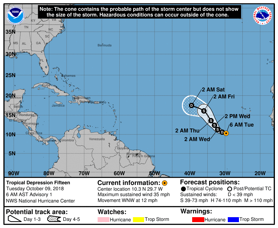
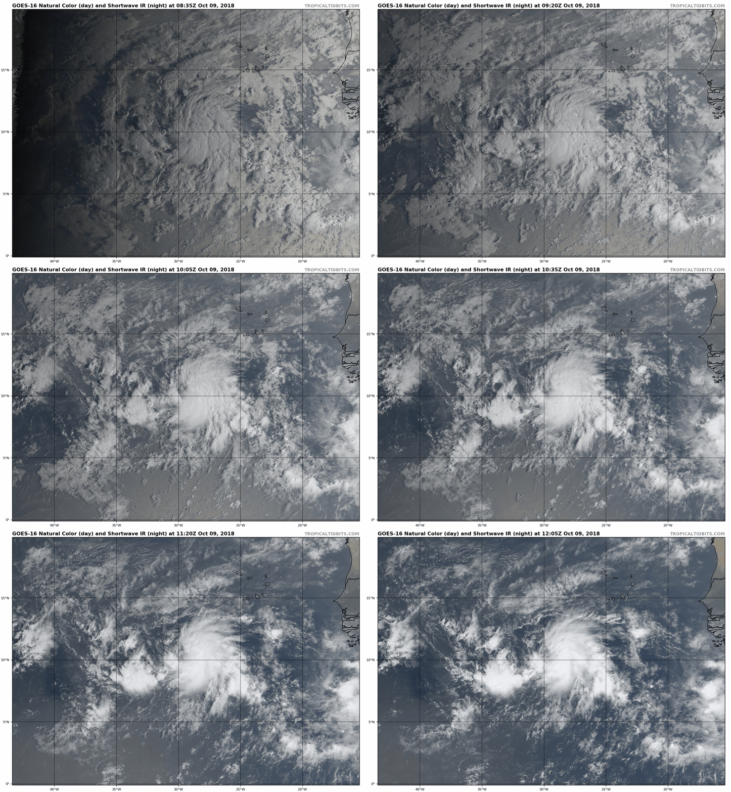
095407_5day_cone_with_line.png

goes16_truecolor_15L.gif
回復

使用道具 舉報

簽到天數: 3291 天

[LV.Master]伴壇終老

t02436|2018-10-10 01:08 | 顯示全部樓層
15Z馬上命名Nadine
000
WTNT45 KNHC 091435
TCDAT5

Tropical Storm Nadine Discussion Number   2
NWS National Hurricane Center Miami FL       AL152018
1100 AM AST Tue Oct 09 2018

The cloud pattern of the cyclone features a curved band that wraps
around the eastern and southern parts of the circulation. Dvorak
estimates from TAFB and SAB are both T2.5/35 kt, and that is used
for the initial intensity, making the system a tropical storm. The
environment appears conducive for some additional strengthening
during the next 24 hours or so, with SSTs above 28C and generally
light to moderate westerly shear. After that time, the shear
increases to 25-30 kt and SSTs along the forecast track fall below
27C by 72 hours. These factors should result in weakening, and all
of the global models show the cyclone dissipating in 4 to 5 days.
The NHC forecast follows these trends and is close to the various
consensus aids through the forecast period.

Based on geostationary imagery and a 0815Z SSMIS pass, the initial
motion estimate is a somewhat uncertain 285/08, with Nadine
currently situated south of a narrow mid-level ridge. The ridge will
weaken as a mid/upper-level trough that Leslie is embedded in digs
southward along 40W longitude. This pattern will cause Nadine to
turn more northwestward by 24 hours. By 96 hours, a weakening Nadine
should bend back to the west as a shallow system. The new NHC track
forecast is a bit to the right of the previous one due to the new
initial position, and lies near HCCA through 48 hours and closer to
the TVCA multi-model consensus after that time.

FORECAST POSITIONS AND MAX WINDS

INIT  09/1500Z 10.5N  30.0W   35 KT  40 MPH
12H  10/0000Z 11.1N  31.0W   40 KT  45 MPH
24H  10/1200Z 11.9N  32.1W   45 KT  50 MPH
36H  11/0000Z 13.0N  33.0W   45 KT  50 MPH
48H  11/1200Z 14.3N  34.1W   40 KT  45 MPH
72H  12/1200Z 16.7N  36.6W   30 KT  35 MPH
96H  13/1200Z 18.0N  40.0W   25 KT  30 MPH...POST-TROP/REMNT LOW
120H  14/1200Z...DISSIPATED

$$
Forecaster Brennan

143651_5day_cone_with_line.png

976021e0-68fe-4156-85a8-8f65901433d2.gif
回復

使用道具 舉報

簽到天數: 3291 天

[LV.Master]伴壇終老

t02436|2018-10-13 11:05 | 顯示全部樓層
已退化成東風波,03Z判定消散。巔峰強度55節、997百帕。
ZCZC MIATCDAT5 ALL
TTAA00 KNHC DDHHMM

Remnants Of Nadine Discussion Number  16
NWS National Hurricane Center Miami FL       AL152018
1100 PM AST Fri Oct 12 2018

ASCAT data indicate that Nadine no longer has a closed circulation
nor a well-defined center.  This is also confirmed by low cloud
motions from GOES-16.  Thus Nadine has degenerated into an open
wave, and this is the last advisory on this system. The initial wind
speed is reduced to 30 kt to match the value from the scatterometer.
Strong shear should cause the remnants to slowly weaken as the
system moves quickly westward beneath the Atlantic subtropical
ridge.

Future information on the remnants of Nadine can be found in High
Seas Forecasts issued by the National Weather Service, under AWIPS
header NFDHSFAT1, WMO header FZNT01 KWBC, and available on the Web
at https://ocean.weather.gov/shtml/NFDHSFAT1.shtml.


FORECAST POSITIONS AND MAX WINDS

INIT  13/0300Z 16.0N  39.5W   30 KT  35 MPH...REMNANTS OF NADINE
12H  13/1200Z...DISSIPATED

$$
Forecaster Blake

NNNN

15L #16.png

LATEST.jpg

20181013.0230.goes-16.ir.15L.NADINE.30kts.1008mb.16N.38.5W.100pc.jpg
回復

使用道具 舉報

快速回覆
您需要登錄後才可以回帖 登錄 | 立即加入

本版積分規則

周子堯@FB

    主題

    帖子

    94萬

    積分

    13級[一級颶風]

    Rank: 13Rank: 13Rank: 13Rank: 13

13級[一級颶風]

發訊息

本平台僅供學術討論之用,預報應以氣象局為準

威普網站虛擬主機贊助公司

臺灣第一個天氣類型社群平台 即時天氣資訊、精準颱風動態

線上客服
FB傳送訊息
廣告行銷
精準行銷 物超所值
官方粉專
發佈 快速回復 返回頂部 返回列表