簽到天數: 3291 天 [LV.Master]伴壇終老
|
 t02436|2018-10-23 19:45
|
顯示全部樓層
t02436|2018-10-23 19:45
|
顯示全部樓層
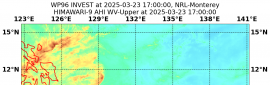
減弱到115節,持續接近陸地,一天以內登陸。
000
WTPZ44 KNHC 230838
TCDEP4
Hurricane Willa Discussion Number 13
NWS National Hurricane Center Miami FL EP242018
300 AM MDT Tue Oct 23 2018
Willa's overall satellite presentation has continued to slowly
degrade since the previous advisory, with the exception of a few
brief attempts at redevelopment of an inner-core ring of deep
convection. However, dry intrusions from the moat region between the
larger outer eyewall and the smaller inner core have thus far
prevented the reformation of an inner eyewall. Satellite intensity
estimates have been steadily decreasing, and the advisory intensity
is set at 115 kt, based on a average of the subjective T- and
CI-numbers from TAFB and a UW-CIMSS ADT objective estimate of
T6.0/115 kt. An Air Force Reserve Unit reconnaissance aircraft is
scheduled to reconnoiter Hurricane Willa later this morning,
providing more detailed intensity information.
The initial motion estimate remains northward, but at a slower
forward speed, or 360/04 kt. There are no significant changes to the
previous track forecast or reasoning. Willa is expected to move
slowly northward this morning around the western periphery of a
deep-layer ridge located over central Mexico, and then recurve
toward the north-northeast and northeast at a faster forward speed
by this afternoon ahead of an approaching mid-latitude trough, with
that motion continuing into this evening and Wednesday. The new NHC
track forecast is near the eastern edge of the tightly packed
guidance envelope, near the FSSE and GFS model tracks.
There has been no microwave imagery since around 0100Z to provide
information on the eyewall replacement cycle (ERC). However,
conventional infrared satellite imagery suggests that the ERC is
still ongoing based on the appearance of a partial moat or clear
region in the northern semicircle of the inner core. Willa is
currently moving over warmer and deeper water as indicated by
upper-ocean heat content (UOHC) values greater than 50 units. This
favorable ocean condition is expected to continue along the forecast
track for another 12 hours or so, which could help to offset the
weakening rate due to the gradual increase in the southwesterly wind
shear. By 18 h, or just before landfall, the shear is forecast to
increase to more than 20 kt and the warm water beneath the hurricane
is expected to become more shallow, a combination that could lead to
significant upwelling and weakening. However, the official intensity
forecast follows the consensus of the various intensity models,
keeping Willa's intensity near 100 kt at landfall, which is similar
to the FSSE and HCCA corrected-consensus models. Despite the
forecast decrease in the peak winds, Willa is expected to remain a
dangerous major hurricane through landfall, bringing
life-threatening storm surge, wind, and rainfall hazards to Las
Islas Marias and portions of west-central and southwestern Mexico
later today. After moving inland, Willa will rapidly weaken, with
dissipation forecast by Wednesday over the high terrain of Mexico.
However, deep moisture from the remnants of Willa is forecast to
spread northeastward over northern Mexico and portions of Texas
where a swath of heavy rainfall is expected midweek.
Key Messages:
1. A life-threatening storm surge is expected today along the coasts
of the Isla Marias, and along the coast of southern Sinaloa and
Nayarit states in west-central and southwestern Mexico near the
path of Willa. Residents should rush preparations to completion to
protect life and property and follow any advice given by local
officials.
2. Everyone in the Isla Marias, and within the hurricane warning
area along the coast of west-central Mexico should prepare for life-
threatening major hurricane winds associated with the core of
Willa. Hurricane force winds will also extend inland across the
mountainous areas of west-central Mexico as Willa moves inland.
3. Heavy rainfall from Willa is likely to produce life-threatening
flash flooding and landslides over much of southwestern and
west-central Mexico.
FORECAST POSITIONS AND MAX WINDS
INIT 23/0900Z 20.8N 107.3W 115 KT 130 MPH
12H 23/1800Z 22.0N 106.5W 100 KT 115 MPH
24H 24/0600Z 23.8N 104.5W 40 KT 45 MPH...INLAND
36H 24/1800Z 25.8N 102.3W 20 KT 25 MPH...POST-TROP/INLAND
48H 25/0600Z...DISSIPATED INLAND
$$
Forecaster Stewart


|
|


 提升卡
提升卡 千斤頂
千斤頂


.gif")