簽到天數: 1650 天 [LV.Master]伴壇終老
|
 老農民版夜神月|2020-2-12 19:18
|
顯示全部樓層
本帖最後由 老農民版夜神月 於 2020-2-13 07:47 編輯
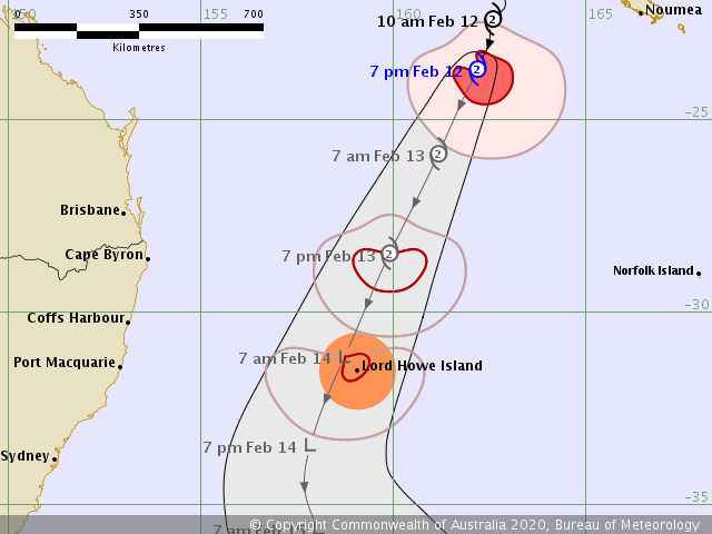
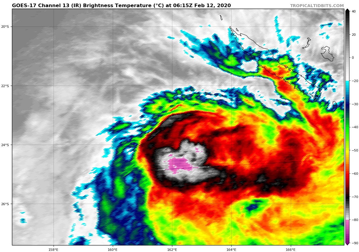
FMS12/06Z對於Uesi發出最後一報TROPICAL DISTURBANCE ADVISORY,同時BoM開始發報,編號06U,定強60KT,預測系統將於未來12H~24H逐步轉化
TROPICAL DISTURBANCE ADVISORY NUMBER A17 ISSUED FROM RSMC NADI
Feb 120820 UTC.
TROPICAL CYCLONE UESI CENTRE 980HPA WAS LOCATED NEAR 23.5S 162.3E AT
120600 UTC. POSITION POOR BASED ON HIMAWARI-8 IR IMAGERY AND
PERIPHERAL SURFACE REPORTS. CYCLONE MOVING SOUTH-SOUTHWEST AT ABOUT
12 KNOTS. MAXIMUM 10-MINUTE AVERAGE WINDS NEAR THE CENTRE ESTIMATED
AT ABOUT 60 KNOTS.
ORGANISATION REMAINS GOOD BUT SYSTEM IS ENCOUNTERING DRY AIR
ENTRAINMENT FROM THE SOUTHEAST. DEEP CONVECTION TRYING TO WRAP ONTO
SUPPOSED LLCC BUT HAS REDUCED IN RADIAL VERTICAL EXTENT. SYSTEM LIES
IN A MODERATE SHEARED ENVIRONMENT WITH GOOD POLEWARD OUTFLOW. SST IS
AROUND 28 DEGREES CELSIUS. UESI IS MOVING SOUTHWARDS ALONG THE
WESTERN PERIPHERY OF SUB TROPICAL RIDGE.
DVORAK ANALYSIS BASED ON EMBEDDED CENTRE IN OW WHICH YIELDS A DT=3.5,
MET AND PT AGREE. FT BASED ON DT THUS, YIELDS T3.5/4.0/W0.5/24HRS.
FORECASTS :
AT 12 HRS VALID AT 121800 UTC 25.4S 161.4E MOV SSW AT 09 KT WITH 50
KT CLOSE TO CENTRE
AT 24 HRS VALID AT 130600 UTC 27.8S 160.1E MOV SSW AT 10 KT WITH 40
KT CLOSE TO CENTRE
OUTLOOK :
AT 36 HRS VALID AT 131800 UTC 30.2S 158.8E MOV SSW AT 11 KT WITH 35
KT CLOSE TO CENTRE
AT 48 HRS VALID AT 140600 UTC 32.4S 157.9E MOV SSW AT 12 KT WITH 30
KT CLOSE TO CENTRE
THIS WILL BE THE LAST TROPICAL DISTURBANCE ADVISORY ON UESI. BRISBANE
TCWC WILL TAKE OVER RESPONSIBILITY FOR UESI FROM THE NEXT ISSUE.
IDQ20018
TROPICAL CYCLONE TECHNICAL BULLETIN: AUSTRALIA - EASTERN REGION
Issued by BRISBANE TROPICAL CYCLONE WARNING CENTRE
at: 0701 UTC 12/02/2020
Name: Tropical Cyclone Uesi
Identifier: 06U
Data At: 0600 UTC
Latitude: 23.4S
Longitude: 162.3E
Location Accuracy: within 25 nm [45 km]
Movement Towards: south southwest [195 deg]
Speed of Movement: 11 knots [20 km/h]
Maximum 10-Minute Wind: 60 knots [110 km/h]
Maximum 3-Second Wind Gust: 85 knots [155 km/h]
Central Pressure: 975 hPa
Radius of 34-knot winds NE quadrant: 90 nm [165 km]
Radius of 34-knot winds SE quadrant: 150 nm [280 km]
Radius of 34-knot winds SW quadrant: 120 nm [220 km]
Radius of 34-knot winds NW quadrant: 60 nm [110 km]
Radius of 48-knot winds NE quadrant: 30 nm [55 km]
Radius of 48-knot winds SE quadrant: 60 nm [110 km]
Radius of 48-knot winds SW quadrant: 40 nm [75 km]
Radius of 48-knot winds NW quadrant:
Radius of 64-knot winds:
Radius of Maximum Winds: 25 nm [45 km]
Dvorak Intensity Code: T3.0/4.0/W1.0/24HRS STT:W0.5/06HRS
Pressure of outermost isobar: 1002 hPa
Radius of outermost closed isobar: 200 nm [370 km]
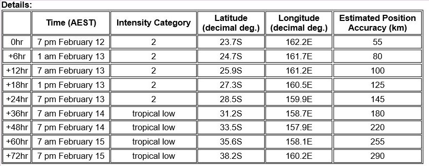
FORECAST DATA
Date/Time : Location : Loc. Accuracy: Max Wind : Central Pressure
[UTC] : degrees : nm [km]: knots[km/h]: hPa
+06: 12/1200: 24.3S 161.9E: 035 [070]: 055 [100]: 980
+12: 12/1800: 25.4S 161.4E: 050 [090]: 055 [100]: 980
+18: 13/0000: 26.8S 160.7E: 060 [115]: 050 [095]: 984
+24: 13/0600: 28.1S 160.1E: 075 [135]: 050 [095]: 983
+36: 13/1800: 30.6S 158.9E: 095 [175]: 045 [085]: 986
+48: 14/0600: 33.1S 157.9E: 115 [210]: 045 [085]: 984
+60: 14/1800: 35.3S 157.6E: 130 [245]: 040 [075]: 986
+72: 15/0600: 37.7S 159.4E: 150 [280]: 040 [075]: 986
+96: 16/0600: 43.1S 164.5E: 195 [365]: 035 [065]: 986
+120: 17/0600: 44.6S 162.4E: 285 [525]: 030 [055]: 989
REMARKS:
Tropical Cyclone Uesi, category 2, lies to the southwest of New Caledonia and is
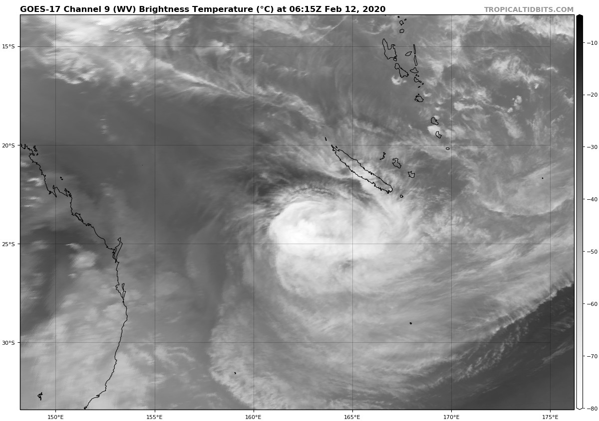
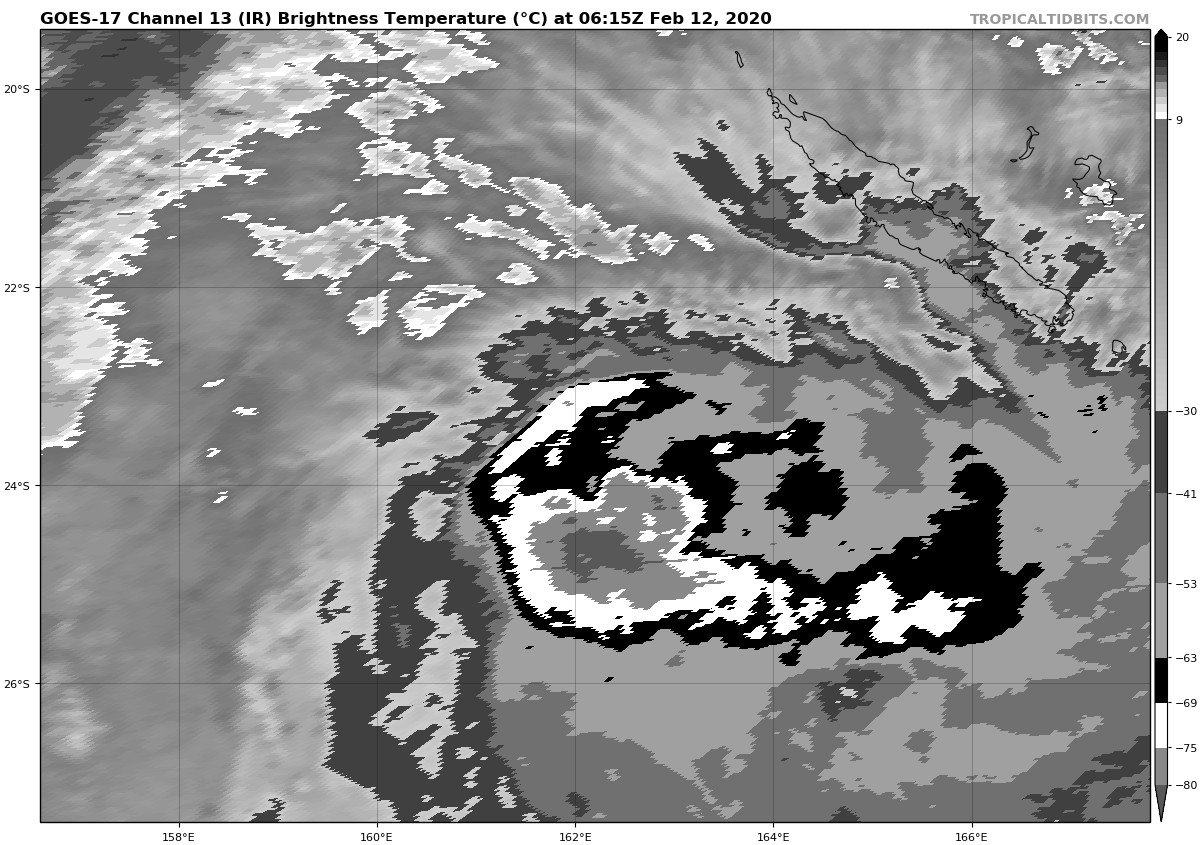
moving towards the south-southwest. Animated satellite imagery and microwave
imagery indicates a sheared system with the LLCC exposed to the northwest of the
deep convection. Dvorak analysis is based on shear pattern gives DT=3.0. Met
agrees. CI is held at 4.0. CIMSS ADT has CI=4.8, FT=3.9, RawT=2.0 [NOAA is
similar].
Despite the increased shear, Uesi maintains a strong core in the lower levels.
Moving further south, Uesi is likely to lose its cloud structure but may
maintain its structure in the lower troposphere as it transitions to an
extra-tropical system in the next 12 to 24 hours. Gale to storm force winds may
persist or expand in the southern quadrants as it moves past Lord Howe Island
during Friday morning.
The steering is determined by the slow-moving upper trough over eastern
Australia and by a blocking high pressure system to the southeast. Model
guidance, both deterministic and ensemble forecasts are showing strong
consistency with a continued southwestwards movement passing close to Lord Howe
Island, and then turning towards the southeast on Saturday. All model guidance
indicates the system will remain offshore, closer to Lord Howe Island.
Copyright Commonwealth of Australia
==
The next bulletin for this system will be issued by: 12/1330 UTC by Brisbane
TCWC.
|
|