開啟輔助訪問
 找回密碼
 立即加入

01L.Arthur 北大首個熱帶風暴

簽到天數: 1650 天

[LV.Master]伴壇終老

2020-5-15 07:54 | 顯示全部樓層
本帖最後由 周子堯@FB 於 2020-5-17 12:16 編輯

  基本資料  
編號    :01 L
擾動編號日期:2020 05 15 04
撤編日期  :2020 05 00 00

90L INVEST 200514 1800 23.7N 81.2W ATL 30 1013
065501z9yy12gyv949kqzv.jpg

  NHC:70%  

1. A trough of low pressure over the Straits of Florida is producing a
large area of cloudiness and thunderstorms. Environmental conditions
are expected to become conducive for development, and this system
is likely to become a tropical or subtropical storm by late Friday
or Saturday when it is located near the northwestern Bahamas. The
system is then forecast to move generally northeastward over the
western Atlantic early next week.

Regardless of development, the disturbance has the potential to
bring heavy rainfall to portions of the Florida Keys, southeast
Florida, and the Bahamas through Saturday. Tropical-storm-force wind
gusts are also possible in the Florida Keys, southeast Florida, and
the Bahamas during the next day or two. Hazardous marine conditions
are also expected along the Florida east coast and in the Bahamas
where Gale Warnings are in effect. See products from your local
weather office and High Seas Forecasts for more details. An Air
Force Reserve Hurricane Hunter aircraft is scheduled to investigate
this system tomorrow, if necessary. The next Special Tropical
Weather Outlook on this system will be issued by 9 PM EDT today, or
earlier, if necessary.
* Formation chance through 48 hours...high...70 percent.
* Formation chance through 5 days...high...80 percent.

two_atl_2d1.png two_atl_5d0.png
two_atl_5d1.png

評分

參與人數 1水氣能量 +15 +1 收起 理由
king111807 + 15 + 1 熱帶擾動首帖

查看全部評分

回復

使用道具 舉報

簽到天數: 1650 天

[LV.Master]伴壇終老

老農民版夜神月|2020-5-16 11:49 | 顯示全部樓層
FWC-N已發布TCFA
SUBJ/TROPICAL CYCLONE FORMATION ALERT//
RMKS/ 1. FORMATION OF A SIGNIFICANT TROPICAL CYCLONE IS POSSIBLE
WITHIN 100 NM EITHER SIDE OF A LINE FROM 25.1N 79.5W TO 27.8N 78.7W
WITHIN THE NEXT 24 HOURS. AVAILABLE DATA DOES NOT JUSTIFY
ISSUANCE OF NUMBERED TROPICAL CYCLONE WARNINGS AT THIS TIME.
WINDS IN THE AREA ARE ESTIMATED TO BE 20 TO 25 KNOTS. METSAT
IMAGERY AT 151800Z INDICATES THAT A CIRCULATION CENTER IS LOCATED
NEAR 25.1N 79.5W. THE SYSTEM IS MOVING NORTHEASTWARD AT 07 KNOTS.
2. AN ELONGATED AREA OF LOW PRESSURE IS LOCATED ABOUT HALF WAY
BETWEEN ANDROS ISLAND, BAHAMAS, AND THE SOUTHEAST COAST OF FLORIDA.
THIS SYSTEM IS PRODUCING A LARGE AREA OF DISORGANIZED SHOWERS AND
THUNDERSTORMS WITH GUSTY WINDS ACROSS THE SOUTHEAST COAST OF
FLORIDA, THE STRAITS OF FLORIDA, AND THE NORTHWESTERN BAHAMAS.
GRADUAL DEVELOPMENT IS ANTICIPATED AND THE LOW PRESSURE SYSTEM
IS EXPECTED TO BECOME A TROPICAL OR SUBTROPICAL STORM DURING THE
NEXT 24 HOURS WHILE IT MOVES NEAR THE NORTHWESTERN BAHAMAS.
3. THIS ALERT WILL BE REISSUED, UPGRADED TO WARNING OR CANCELLED
BY 162000Z.//

未命名.png GOES03302020137saZcxY.jpg
90L_gefs_latest.png
回復

使用道具 舉報

簽到天數: 1650 天

[LV.Master]伴壇終老

老農民版夜神月|2020-5-17 06:58 | 顯示全部樓層
本帖最後由 老農民版夜神月 於 2020-5-17 07:00 編輯

NHC於16/21Z升格90L為TD01L,首報預測其將逐漸增強至50KT後轉化
WTNT41 KNHC 162039
TCDAT1

Tropical Depression One Discussion Number   1
NWS National Hurricane Center Miami FL       AL012020
500 PM EDT Sat May 16 2020

Satellite images, Doppler radar data, and surface observations
indicate that the low pressure system located just east of the coast
of central Florida has developed sufficient organization to now be
classified as a tropical depression.  The low-level center is well
defined and deep convection has persisted near the center and in
bands on the east side of the circulation for the past several
hours.  The cyclone is considered tropical instead of subtropical
because it has central deep convection and a relatively small radius
of maximum wind.  The initial intensity is estimated to be 30 kt
based on data collected earlier today by the Air Force Hurricane
Hunters.  Another aircraft is scheduled to investigate the system
this evening.

Based on satellite data and the earlier reconnaissance fixes, the
initial motion of the system is north-northeastward at 11 kt.  A
continued north-northeastward motion at about the same forward speed
is expected during the next 24 hours or so, keeping the cyclone
offshore, but parallel to, the east coast of Florida.  After that
time,
the model solutions begin to diverge and the details of the track
forecast become more complicated.  The important features for the
future track of the depression appear to be a pair of mid- to
upper-level troughs currently over the central U.S. The specific
amplitude, timing, and location of those troughs will ultimately
result in how close to the coast of North Carolina this system gets.
The GFS and HWRF models are on the left side of the guidance and
bring the system inland or along the coast, while the ECMWF and
UKMET models show an offshore track. The NHC track forecast splits
the difference of these solutions, and lies close to the various
consensus models, which usually perform best.  It should be noted
that forecast uncertainty is typically larger for weak systems like
this one.

The system should gradually strengthen during the next couple of
days as it remains over the Gulf Stream current and in relatively
low wind shear conditions. However, the surrounding air mass is not
particularly moist, so that and the marginally warm SSTs should
limit significant intensification. The NHC intensity forecast calls
for the system to become a tropical storm tonight or on Sunday with
continued slow strengthening as it nears the North Carolina coast.
Extratropical transition should occur in about 3 days, or sooner.
The NHC intensity forecast generally lies roughly near the middle of
the guidance envelope.

Key Messages:

1. A tropical storm watch has been issued for a portion of the
North Carolina coast.  Tropical-storm-force winds and heavy rains
are possible there on Monday.

2. Dangerous coastal surf conditions and rip currents are expected
to spread northward from Florida to the mid-Atlantic states during
the next few days.  See products from your local National Weather
Service for more details.


FORECAST POSITIONS AND MAX WINDS

INIT  16/2100Z 28.4N  78.6W   30 KT  35 MPH
12H  17/0600Z 29.7N  78.0W   35 KT  40 MPH
24H  17/1800Z 31.4N  77.4W   35 KT  40 MPH
36H  18/0600Z 33.0N  76.6W   40 KT  45 MPH
48H  18/1800Z 35.2N  74.8W   45 KT  50 MPH
60H  19/0600Z 37.1N  72.3W   50 KT  60 MPH
72H  19/1800Z 38.0N  70.0W   50 KT  60 MPH...POST-TROP/EXTRATROP
96H  20/1800Z 38.0N  68.5W   45 KT  50 MPH...POST-TROP/EXTRATROP
120H  21/1800Z...DISSIPATED

$$
Forecaster Cangialosi

AL012020_5day_cone_no_line_and_wind.png
goes16_ir_01L_202005162132.gif
goes16_vis_01L_202005162137.gif
回復

使用道具 舉報

簽到天數: 2088 天

[LV.Master]伴壇終老

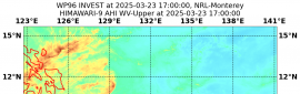
周子堯@FB|2020-5-17 12:15 | 顯示全部樓層

北大首個熱帶風暴生成,NHC判定副熱帶風暴,並於17/03Z命名Arthur
WTNT41 KNHC 170253
TCDAT1

Tropical Storm Arthur Discussion Number   2
NWS National Hurricane Center Miami FL       AL012020
1100 PM EDT Sat May 16 2020

An Air Force Reserve reconnaissance aircraft that has been
investigating the tropical cyclone east of Florida has recently
found maximum 925-mb flight-level winds of 45-46 kt to the
southeast and east of the center, which equates to surface winds
of 34-35 kt, along with uncontaminated SFMR surface wind speeds of
33-36 kt. Based on these data, the depression has been upgraded to
Tropical Storm Arthur, the first named storm of the 2020 Atlantic
hurricane season.

The initial motion estimate remains north-northeastward or 030/11
kt. Arthur made a slight northeastward jog earlier this evening,
but now appears to have returned to its previous base course. A
motion toward the north-northeast is forecast to continue for the
next 24 hours or so, keeping the cyclone well offshore the coasts
of Florida and Georgia. A sharp shortwave trough currently moving
across the southern Plains is forecast to dig east-southeast to
southeastward over the next 48 hours, which will act to accelerate
and eject Arthur more poleward. The more the shortwave trough digs
and loses latitude, the more Arthur could get pulled closer to
the North Carolina Outer Banks as per the GFS and HWRF scenarios.
In contrast, the ECMWF and UKMET models show the shortwave losing
amplitude quickly and lifting out, which acts to push Arthur
farther away from the United States east coast. For now, the new
NHC forecast track closely follows the various consensus models,
which are about midway between the GFS-HWRF and ECMWF-UKMET
solutions. However, the track was adjusted slightly to the right of
the previous advisory track due mainly to the more eastward initial
position. It should be noted that forecast track uncertainty is
typically larger for weak systems like Arthur.

Arthur has moved off of the warm waters of the Gulfstream current
and currently is passing over a cold pool with SSTs near 24.5 deg
C. These cooler waters should prevent any significant strengthening
in the very near term. By 24 hours however, the cyclone is forecast
to pass back over the warmer waters of the Gulfstream while moving
into a very low vertical wind shear regime. These conditions,
coupled with some cooler air aloft, should allow more vigorous
convection to develop near the center, resulting in more
strengthening as Arthur passes near the North Carolina coast.
Extratropical transition should occur in about 48-60 hours over the
much cooler waters of the North Atlantic. The NHC intensity
forecast follows a blend of the consensus models HCCA and IVCN, and
is similar to the previous intensity forecast.

Key Messages:

1. A tropical storm watch is in effect for a portion of the
North Carolina coast.  Tropical-storm-force winds and heavy rains
are possible there on Monday.

2. Dangerous coastal surf conditions and rip currents are expected
to spread northward from Florida to the mid-Atlantic states during
the next few days.  See products from your local National Weather
Service Forecast Office for more details.


FORECAST POSITIONS AND MAX WINDS

INIT  17/0300Z 29.4N  77.7W   35 KT  40 MPH
12H  17/1200Z 30.5N  77.2W   35 KT  40 MPH
24H  18/0000Z 32.2N  76.4W   40 KT  45 MPH
36H  18/1200Z 34.1N  75.2W   45 KT  50 MPH
48H  19/0000Z 36.2N  73.0W   45 KT  50 MPH
60H  19/1200Z 37.5N  70.6W   50 KT  60 MPH...POST-TROP/EXTRATROP
72H  20/0000Z 38.0N  69.1W   50 KT  60 MPH...POST-TROP/EXTRATROP
96H  21/0000Z 38.0N  67.6W   45 KT  50 MPH...POST-TROP/EXTRATROP
120H  22/0000Z...DISSIPATED

$$
Forecaster Stewart
110456jqa1gqse1qj33jxo.png
d65a0484-5b2f-40b1-9334-27f5da943195.gif
回復

使用道具 舉報

簽到天數: 1650 天

[LV.Master]伴壇終老

老農民版夜神月|2020-5-19 23:58 | 顯示全部樓層
本帖最後由 老農民版夜神月 於 2020-5-20 00:26 編輯

NHC19/15Z報判定Arthur已轉化為溫帶氣旋
ZCZC MIATCDAT1 ALL
TTAA00 KNHC DDHHMM

Post-Tropical Cyclone Arthur Discussion Number  12
NWS National Hurricane Center Miami FL       AL012020
1100 AM AST Tue May 19 2020

Arthur has transitioned into an extratropical low this morning with
a warm front extending northeastward from the circulation, any deep
convection only along the front, and lots of more stable cumulus
clouds near the center.  Thus this is the last advisory.  The
initial intensity remains 50 kt based on continuity and model
analyses.

The main adjustments to the previous forecast include a quicker
dissipation of the post-tropical cyclone, somewhat linked to the
models showing a faster weakening after 12 hours, and a
continuation of the westward shift in the track forecast in a day
or two.  These changes are consistent with the latest model
consensus for track and similar to a GFS/ECMWF blend for intensity.

Dangerous coastal surf conditions and rip currents are expected to
continue along portions of the mid-Atlantic and southeast U.S.
coasts during the next couple of days.  See products from your local
National Weather Service Forecast Office for more details.


FORECAST POSITIONS AND MAX WINDS

INIT  19/1500Z 36.8N  68.6W   50 KT  60 MPH...POST-TROPICAL
12H  20/0000Z 36.4N  66.9W   50 KT  60 MPH...POST-TROP/EXTRATROP
24H  20/1200Z 35.2N  65.6W   45 KT  50 MPH...POST-TROP/EXTRATROP
36H  21/0000Z 33.6N  65.0W   40 KT  45 MPH...POST-TROP/EXTRATROP
48H  21/1200Z 32.0N  64.5W   30 KT  35 MPH...POST-TROP/EXTRATROP
60H  22/0000Z...DISSIPATED

$$
Forecaster Blake

NNNN

goes16_vis_01L_202005191502.gif 144748_5day_cone_with_line_and_wind.png
goes16_ir_01L_202005191432.gif GOES15362020140A6RABE.jpg
回復

使用道具 舉報

快速回覆
您需要登錄後才可以回帖 登錄 | 立即加入

本版積分規則

本平台僅供學術討論之用,預報應以氣象局為準

威普網站虛擬主機贊助公司

臺灣第一個天氣類型社群平台 即時天氣資訊、精準颱風動態

線上客服
FB傳送訊息
廣告行銷
精準行銷 物超所值
官方粉專
發佈 快速回復 返回頂部 返回列表