開啟輔助訪問
 找回密碼
 立即加入

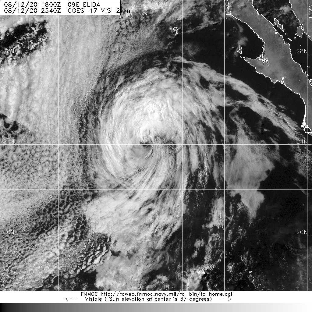
09E.Elida 曾達C2強度 後減弱消散

簽到天數: 601 天

[LV.9]以壇為家II

霧峰追風者|2020-8-13 08:08 | 顯示全部樓層
強度減弱至45KT。
000
WTPZ44 KNHC 122036
TCDEP4

Tropical Storm Elida Discussion Number  16
NWS National Hurricane Center Miami FL       EP092020
200 PM PDT Wed Aug 12 2020

Elida's last remaining deep convection dissipated just after the
issuance of the previous advisory, brought on by cold ocean water
of only 22-23 degrees Celsius.  Of the two ASCAT passes near the
cyclone today, neither caught the likely area of strongest winds.
Therefore, the maximum winds are lowered to 45 kt based on a blend
of subjective estimates between 45-55 kt and objective numbers
between 30-40 kt.  Cold water and increasing shear should continue
Elida's quick weakening trend, and the cyclone is expected to
degenerate into a remnant low by tonight, barring the unlikely
chance that deep convection redevelops.  The remnant low is then
forecast to dissipate in 48 hours in accordance with global model
guidance.

The initial motion is still west-northwestward, or 295/10 kt.  A
low- to mid-level trough extending southwest of California, which
has caused a break in the subtropical ridge, is expected to allow
Elida to turn northwestward and then north-northwestward soon.
This forecast reasoning has not changed, however one change to the
new NHC track forecast is that it is not as fast as is being shown
by the model trackers.  Global model fields suggest that
Elida's low- to mid-level circulation will get pulled northward by
increasing shear (which is reflected by the model trackers),
leaving the surface circulation to the south.  Given this
discrepancy, the NHC forecast is to the south of most of the
guidance to account for the actual location of the surface center.


FORECAST POSITIONS AND MAX WINDS

INIT  12/2100Z 23.7N 119.6W   45 KT  50 MPH
12H  13/0600Z 24.5N 120.6W   30 KT  35 MPH...POST-TROP/REMNT LOW
24H  13/1800Z 25.8N 121.4W   25 KT  30 MPH...POST-TROP/REMNT LOW
36H  14/0600Z 27.2N 121.9W   20 KT  25 MPH...POST-TROP/REMNT LOW
48H  14/1800Z...DISSIPATED

$$
Forecaster Berg
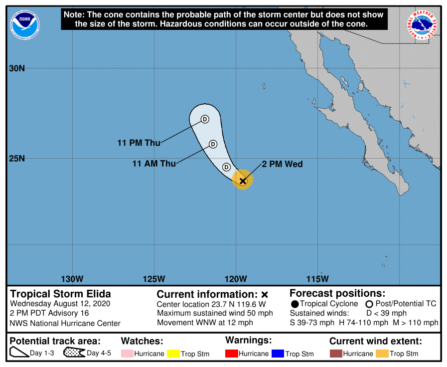
203802_5day_cone_no_line_and_wind.png 20200812.2340.goes-17.vis.2km.09E.ELIDA.45kts.1000mb.23.5N.119.3W.pc.jpg
回復

使用道具 舉報

簽到天數: 53 天

[LV.5]常住居民I

天篷大元帥|2020-8-13 11:04 | 顯示全部樓層

GG
原文:
000
WTPZ44 KNHC 130235
TCDEP4

Post-Tropical Cyclone Elida Discussion Number  17
NWS National Hurricane Center Miami FL       EP092020
800 PM PDT Wed Aug 12 2020

Elida has been devoid of deep convection for more than 12 hours, and
since it is over SSTs of 22-23 degrees Celsius, it is unlikely that
organized deep convection will return.  As a result, the system
has become a post-tropical cyclone
, and this will be the last NHC
advisory on Elida.  The initial intensity has been set at 35 kt,
which is a blend of the latest Dvorak T- and CI-numbers from TAFB
and SAB.  The cyclone is heading toward even cooler waters and a
more stable environment.  Continued weakening is therefore
expected, and the remnant low is forecast to dissipate by Friday
morning.

The initial motion estimate is 315/8 kt. A low- to mid-level
trough located to the northwest of the cyclone has caused a break
in the subtropical ridge.  This has allowed the system to turn
northwestward, and a northwestward to north-northwestward motion is
expected to continue until dissipation occurs on Friday. The global
model guidance continues to suggest that the low-level center will
decelerate as the mid-level circulation is pulled northward ahead
of the aforementioned trough.  The new NHC track foreast is similar
to the previous advisory and again shows a slower forward motion
than the global model trackers.

This is the last NHC advisory on Elida.  For additional information
on this system please see High Seas Forecasts issued by the
National Weather Service, under AWIPS header NFDHSFEPI, WMO header
FZPN02 KWBC, and on the web at ocean.weather.gov/shtml/NFDHSFEPI.php


FORECAST POSITIONS AND MAX WINDS

INIT  13/0300Z 24.4N 120.2W   35 KT  40 MPH...POST-TROPICAL
12H  13/1200Z 25.3N 121.0W   25 KT  30 MPH...POST-TROP/REMNT LOW
24H  14/0000Z 26.6N 121.5W   20 KT  25 MPH...POST-TROP/REMNT LOW
36H  14/1200Z...DISSIPATED

$$
Forecaster Brown

機器翻譯(翻譯品質差僅供參考):
000
WTPZ44 KNHC 130235 TCDEP4
埃里達

熱帶風暴後討論編號17
NWS邁阿密颶風中心美國佛羅里達州EP092020
800 PM PDT 2020年8月12日星期三

Elida一直沒有深對流超過12個小時,並且
由於其SST超過22-23攝氏度,
有組織的深對流不太可能恢復。結果,該系統
已成為熱帶後氣旋
,這將是
Elida 上最新的NHC 諮詢。初始強度設定為35 kt,
是TAFB
和SAB 的最新Dvorak T和CI編號的混合。旋風正朝著更涼的水和
更穩定的環境。因此,
預計將持續走弱,預計剩餘的低點將在周五
早上消散。

初始運動估計為315/8 kt。
旋风西北部的低至中層低谷造成了
亞熱帶海脊的破裂。這使系統可以向
西北轉動,並且從西北向北向西北的運動
預計將持續到星期五消散。全球
模型指南繼續表明,
隨著中層環流
在上述谷底之前向北拉動,低層中心將減速。新的NHC東方賽道類似
到先前的諮詢,並且再次顯示出
比全局模型跟踪器慢的前進速度。

這是NHC關於Elida的最新諮詢。有關
此系統的更多信息,請參閱
國家氣象局發布的“公海預報” ,位於AWIPS標頭NFDHSFEPI,WMO標頭
FZPN02 KWBC下,以及位於以下網址的網絡ocean.weather.gov/shtml/NFDHSFEPI.php


預測位置和最大風速

INIT 13 / 0300Z 24.4N 120.2W 35 KT 40 MPH ...後熱帶
12H 13 / 1200Z 25.3N 121.0W 25 KT 30 MPH ...後熱帶/短低
24H 14 / 0000Z 26.6N 121.5W 20 KT 25 MPH ...後低/後低
36H 14 / 1200Z ...已分發

$$
Forecaster Brown

回復

使用道具 舉報

12
快速回覆
您需要登錄後才可以回帖 登錄 | 立即加入

本版積分規則

本平台僅供學術討論之用,預報應以氣象局為準

威普網站虛擬主機贊助公司

臺灣第一個天氣類型社群平台 即時天氣資訊、精準颱風動態

線上客服
FB傳送訊息
廣告行銷
精準行銷 物超所值
官方粉專
發佈 快速回復 返回頂部 返回列表