開啟輔助訪問
 找回密碼
 立即加入

93E 環境轉差 一度發佈TCFA

簽到天數: 601 天

[LV.9]以壇為家II

2020-8-12 02:36 | 顯示全部樓層
  基本資料  
編號    :93 E
擾動編號日期:2020 08 13 02
撤編日期  :2020 08 16 09
93E.INVEST.20kts-1008mb-14N-104W

20200812.2110.goes-17.vis.2km.93E.INVEST.20kts.1008mb.14N.104W.pc.jpg
NHC:70%
2. A large area of disturbed weather associated with a trough of low
pressure extends several hundred miles southwest of the
southwestern coast of Mexico.  Environmental conditions appear
conducive for development, and a tropical depression is
expected to form during the next few days before the system
reaches cooler waters over the weekend.  This system is forecast to
move west-northwestward at about 15 mph away from the coast of
southwestern Mexico.
* Formation chance through 48 hours...high...70 percent.
* Formation chance through 5 days...high...90 percent.

two_pac_2d2 (2).png

評分

參與人數 1水氣能量 +15 +1 收起 理由
king111807 + 15 + 1 熱帶擾動首帖

查看全部評分

回復

使用道具 舉報

簽到天數: 601 天

[LV.9]以壇為家II

霧峰追風者|2020-8-13 05:54
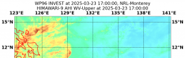
 | 顯示全部樓層
21Z 發布"TCFA"。
WTPN22 PHNC 122100
MSGID/GENADMIN/JOINT TYPHOON WRNCEN PEARL HARBOR HI//
SUBJ/TROPICAL CYCLONE FORMATION ALERT (INVEST 93E)//
REF/A/JOINT TYPHOON WRNCEN PEARL HARBOR HI/120651Z AUG 20//
AMPN/REF A IS TROPICAL CYCLONE FORMATION ALERT (WTPN21 PHNC 120700)//
RMKS/
1. FORMATION OF A SIGNIFICANT TROPICAL CYCLONE IS POSSIBLE WITHIN
160 NM EITHER SIDE OF A LINE FROM 13.5N 103.2W TO 17.5N 110.2W
WITHIN THE NEXT 12 TO 24 HOURS. AVAILABLE DATA DOES NOT JUSTIFY
ISSUANCE OF NUMBERED TROPICAL CYCLONE WARNINGS AT THIS TIME.
WINDS IN THE AREA ARE ESTIMATED TO BE 10 TO 15 KNOTS. METSAT
IMAGERY AT 121800Z INDICATES THAT A CIRCULATION CENTER IS LOCATED
NEAR 14.0N 104.0W. THE SYSTEM IS MOVING WESTWARD AT 16 KNOTS.
2. REMARKS: AN AREA OF CONVECTION (INVEST 93E) HAS PERSISTED NEAR
14.0N 104.0W, APPROXIMATELY 299 NM SOUTH OF MANZANILLA, MEXICO.
ANIMATED MULTISPECTRAL SATELLITE IMAGERY DEPICTS A VERY BROAD, WEAK
LOW LEVEL CIRCULATION WITH A SMALL AREA OF BUILDING DEEP CONVECTION
OVERHEAD. A 121502Z METOP-B ASCAT PASS REVEALS AN LLC DOMINATED BY
TROUGHING WITH SWATHS OF 15 TO 20 KNOT WINDS OFFSET TO THE NORTH-
AND SOUTH-EAST. 93E IS CURRENTLY IN A FAVORABLE ENVIRONMENT WITH
GOOD EQUATORWARD OUTFLOW, LOW (5 TO 10 KNOT) VERTICAL WIND SHEAR,
AND WARM (30 TO 31 CELSIUS) SEA SURFACE TEMPERATURES. GLOBAL MODELS
ARE IN GOOD AGREEMENT THAT 93E WILL TRACK GENERALLY NORTHWESTWARD;
HOWEVER, DISAGREE ON DEVELOPMENT, WITH GFS SHOWING SIGNIFICANT
INTENSIFICATION AND NAVGEM SHOWING ALMOST NO INTENSIFICATION.
MAXIMUM SUSTAINED SURFACE WINDS ARE ESTIMATED AT 10 TO 15 KNOTS.
MINIMUM SEA LEVEL PRESSURE IS ESTIMATED TO BE NEAR 1010 MB. THE
POTENTIAL FOR THE DEVELOPMENT OF A SIGNIFICANT TROPICAL CYCLONE
WITHIN THE NEXT 24 HOURS IS HIGH.
3. THIS ALERT WILL BE REISSUED, UPGRADED TO WARNING OR CANCELLED BY
132100Z.
4. SEE REF A (WTPN21 PHNC) FOR DETAILS ON A TROPICAL CYCLONE
FORMATION ALERT LOCATED NEAR 11.3N 128.2W.//
NNNN
0D4C2F94-72D4-4C8E-B131-B4637EBF7252.gif A9D6CF0B-8142-4030-8F0D-6938B01C6C42.jpeg

評分

參與人數 1水氣能量 +15 收起 理由
king111807 + 15 TCFA

查看全部評分

回復

使用道具 舉報

簽到天數: 3198 天

[LV.Master]伴壇終老

king111807|2020-8-14 21:57 | 顯示全部樓層
NHC展望提升至80%
1. An elongated area of low pressure stretches from a few hundred miles
south of the southern tip of the Baja California peninsula
southwestward several hundred miles. The northeastern portion of the
trough has slowly organized during the past couple of days and is
producing persistent shower and thunderstorm activity.
Environmental conditions are expected to be conducive for
development and a tropical depression is likely to form during the
next day or so while the system moves west-northwestward or
northwestward at 10 to 15 mph.  The system is forecast to move over
colder waters over the weekend and further development is unlikely
after that time.
* Formation chance through 48 hours...high...80 percent.
* Formation chance through 5 days...high...80 percent.
two_pac_2d1.png
回復

使用道具 舉報

簽到天數: 601 天

[LV.9]以壇為家II

霧峰追風者|2020-8-15 08:48 | 顯示全部樓層
NHC 展望降低至60。
1. Satellite data indicate that the circulation associated with an area
of low pressure located about 175 miles south-southwest of the
southern tip of the Baja California peninsula has become a little
better defined since yesterday. However, the associated shower
activity remains limited.  While some additional development of this
system is possible, the low is forecast to reach cooler waters on
Saturday and the chance of this system becoming a tropical
depression appears to be decreasing.
* Formation chance through 48 hours...medium...60 percent.
* Formation chance through 5 days...medium...60 percent.
two_pac_2d1.png 20200815.0020.goes-17.ir.93E.INVEST.25kts.1006mb.20.9N.111.3W.100pc.jpg
回復

使用道具 舉報

簽到天數: 3198 天

[LV.Master]伴壇終老

king111807|2020-8-15 21:20 | 顯示全部樓層
NHC展望降至Low,20%
1. An area of low pressure located a few hundred miles west of the
southern tip of the Baja California Peninsula is producing a small
area of showers. This system has moved over colder waters and
further development is unlikely.
* Formation chance through 48 hours...low...20 percent.
* Formation chance through 5 days...low...20 percent.
two_pac_2d1.png
回復

使用道具 舉報

簽到天數: 1650 天

[LV.Master]伴壇終老

老農民版夜神月|2020-8-16 03:02 | 顯示全部樓層
NHC展望已降至0%
1. A trough of low pressure located a few hundred miles west of the
southern tip of the Baja California Peninsula is producing a small
area of showers. This system has moved over colder waters and
further development is unlikely.
* Formation chance through 48 hours...low...near 0 percent.
* Formation chance through 5 days...low...near 0 percent.

two_pac_2d1.png 20200815.1820.goes-17.vis.2km.93E.INVEST.25kts.1006mb.22.2N.114.1W.pc.jpg
LATEST.jpg
回復

使用道具 舉報

快速回覆
您需要登錄後才可以回帖 登錄 | 立即加入

本版積分規則

本平台僅供學術討論之用,預報應以氣象局為準

威普網站虛擬主機贊助公司

臺灣第一個天氣類型社群平台 即時天氣資訊、精準颱風動態

線上客服
FB傳送訊息
廣告行銷
精準行銷 物超所值
官方粉專
發佈 快速回復 返回頂部 返回列表