開啟輔助訪問
 找回密碼
 立即加入

12E.Genevieve 東太今年最強颶風 自下加利福尼亞半島西岸北上

簽到天數: 601 天

[LV.9]以壇為家II

2020-8-15 08:22 | 顯示全部樓層
  基本資料  
編號    :12 E
擾動編號日期:2020 08 15 08
撤編日期  :2020 08 23 02
95E.INVEST.15kts-1004mb-10.0N-95W

20200815.0000.goes-17.ir.95E.INVEST.15kts.1004mb.10N.95W.100pc.jpg
3. A trough of low pressure continues to produce disorganized
showers and thunderstorms just offshore of the Pacific coast of
Central America. Conditions are expected to be conducive for a low
pressure system to develop from this trough over the next day or
so, and a tropical depression or storm is likely to form this
weekend or early next week while the system moves generally
west-northwestward just offshore of the southwestern coast of
Mexico.
* Formation chance through 48 hours...high...70 percent.
* Formation chance through 5 days...high...90 percent

two_pac_2d3 (1).png

巔峰強度:115KT/950hPa

評分

參與人數 1水氣能量 +15 +1 收起 理由
周子堯@FB + 15 + 1 95E

查看全部評分

回復

使用道具 舉報

簽到天數: 2141 天

[LV.Master]伴壇終老

周子堯@FB|2020-8-15 09:42 | 顯示全部樓層
JTWC 01Z亦發布TCFA
1. FORMATION OF A SIGNIFICANT TROPICAL CYCLONE IS POSSIBLE WITHIN
160 NM EITHER SIDE OF A LINE FROM 9.9N 85.7W TO 11.5N 93.5W
WITHIN THE NEXT 12 TO 24 HOURS. AVAILABLE DATA DOES NOT JUSTIFY
ISSUANCE OF NUMBERED TROPICAL CYCLONE WARNINGS AT THIS TIME.
WINDS IN THE AREA ARE ESTIMATED TO BE 15 TO 20 KNOTS. METSAT
IMAGERY AT 150000Z INDICATES THAT A CIRCULATION CENTER IS LOCATED
NEAR 10.1N 86.5W. THE SYSTEM IS MOVING WESTWARD AT 16 KNOTS.
2. REMARKS: AN AREA OF CONVECTION (INVEST 95E) HAS PERSISTED NEAR
10.1N 86.5W, APPROXIMATELY 74 NM SOUTH-SOUTHWEST OF SAN JUAN DEL
SUR, NICARAGUA. ANIMATED ENHANCED INFRARED SATELLITE IMAGERY, ALONG
WITH A 150006Z SSMIS 91GHZ MICROWAVE IMAGE, SHOWS 95E TO BE A WEAK
LOW LEVEL CIRCULATION (LLC) THAT RECENTLY MOVED OVER THE PACIFIC
OCEAN. THERE IS SPARSE, DISORGANIZED DEEP CONVECTION ASSOCIATED WITH
THE LLC AT THIS TIME. 95E IS CURRENTLY IN A FAVORABLE ENVIRONMENT
WITH EXCELLENT EQUATORWARD OUTFLOW, DEVELOPING POLEWARD OUTFLOW, LOW
(15 TO 20 KNOT) VERTICAL WIND SHEAR, AND WARM (29 TO 30 CELSIUS) SEA
SURFACE TEMPERATURES. GLOBAL MODELS ARE IN GOOD AGREEMENT THAT 95E
WILL TRACK GENERALLY WEST-NORTHWESTWARD WITH QUICK CONSOLIDATION AND
INTENSIFICATION. MAXIMUM SUSTAINED SURFACE WINDS ARE ESTIMATED AT 15
TO 20 KNOTS. MINIMUM SEA LEVEL PRESSURE IS ESTIMATED TO BE NEAR 1007
MB. THE POTENTIAL FOR THE DEVELOPMENT OF A SIGNIFICANT TROPICAL
CYCLONE WITHIN THE NEXT 24 HOURS IS HIGH.
ep9520.gif


評分

參與人數 1水氣能量 +15 收起 理由
king111807 + 15 TCFA

查看全部評分

回復

使用道具 舉報

簽到天數: 3206 天

[LV.Master]伴壇終老

king111807|2020-8-15 21:12 | 顯示全部樓層
NHC展望提升至80%
3. Showers and thunderstorms associated with a trough of low pressure
located several hundred miles southeast of the Gulf of Tehuantepec
are beginning to show signs of organization. Conditions appear
conducive for further development and a tropical depression or
tropical storm is likely to form later this weekend or early next
week while the system moves generally west-northwestward just
offshore of the southwestern coast of Mexico.
* Formation chance through 48 hours...high...80 percent.
* Formation chance through 5 days...high...90 percent.
two_pac_2d3.png
回復

使用道具 舉報

簽到天數: 1650 天

[LV.Master]伴壇終老

老農民版夜神月|2020-8-16 02:47 | 顯示全部樓層
NHC展望持續提升至90%
3. A low pressure system located several hundred miles southeast of the
Gulf of Tehuantepec continues to show signs of development. A broad
and elongated closed low pressure system has formed, and the
associated shower and thunderstorm activity is beginning to organize
into bands. Although recent satellite-derived wind data indicate
that the system does not yet have a well-defined center, environment
conditions appear conducive for further development. A tropical
depression or tropical storm will likely form tonight or on Sunday
while the system moves generally west-northwestward just offshore of
the southwestern coast of Mexico.
* Formation chance through 48 hours...high...90 percent.
* Formation chance through 5 days...high...90 percent.

two_pac_2d3.png 20200815.1810.goes-17.vis.2km.95E.INVEST.25kts.1008mb.9.7N.90.2W.pc.jpg
20200815.1244.f17.composite.95E.INVEST.25kts.1008mb.9.7N.90.2W.100pc.jpg LATEST.jpg

回復

使用道具 舉報

簽到天數: 12 天

[LV.3]偶爾看看II

趙育成|2020-8-16 20:37 來自手機 | 顯示全部樓層
本帖最後由 趙育成 於 2020-8-16 20:49 編輯

NHC展望提升到100%
引用1. Showers and thunderstorms associated with a low pressure system
located a few hundred miles south of the Gulf of Tehuantepec have
continued to become better organized overnight, and it appears
that a tropical depression or storm is forming.  If these
development trends continue, advisories will be issued on this
system this morning.  The low is expected to move generally
west-northwestward, well offshore of the southwestern coast of
Mexico during the next few days.  Additional information on this
system can be found in High Seas Forecasts issued by the National
Weather Service.
* Formation chance through 48 hours...high...near 100 percent.
* Formation chance through 5 days...high...near 100 percent.
two_pac_2d0.png
回復

使用道具 舉報

簽到天數: 3291 天

[LV.Master]伴壇終老

t02436|2020-8-16 22:49 | 顯示全部樓層
15Z升格12E,看好發展,初報巔峰上望MH。
000
WTPZ42 KNHC 161445
TCDEP2

Tropical Depression Twelve-E Discussion Number   1
NWS National Hurricane Center Miami FL       EP122020
1000 AM CDT Sun Aug 16 2020

Deep convection associated with the area of low pressure located
south-southwest of the Gulf of Tehuantepec has increased and become
better organized overnight and this morning.  In fact, bands of
convection can be seen in both visible and infrared satellite
imagery around the northwestern portion of the circulation. Dvorak
T-numbers from SAB and TAFB are a consensus 2.0, which supports an
initial intensity of 30 kt.  The depression lies within a very
favorable environment for strengthening. These conditions
consisting of warm waters and low vertical wind shear are expected
to allow for rapid strengthening over the next 48-60 hours. Since
the system is still in its organizational stage, intensification is
likely to be a little more tempered today, but given these very
favorable conditions a period of rapid strengthening is anticipated
to begin by Monday and continue into Tuesday.  The statistical
guidance and dynamical hurricane models are quite bullish on
deepening, as are the global models.  The SHIPS RI index is
showing a 64 percent chance of a 65 kt increase in wind speed over
the next 72 hours.  Since nearly all of the intensity guidance is
calling for a rather rapid increase in strength, this gives
relatively high confidence that the system will become a hurricane
in a day or two, and likely become a major hurricane within 72
hours. The NHC intensity forecast is a blend of the SHIPS and HFIP
correct consensus models.

The depression is moving west-northwestward or 285/16 kt.  A strong
deep layer ridge of high pressure over the western United States
should steer the cyclone on a steady west-northwestward heading over
the next several days.  The guidance suggests that there will be
some reduction in forward speed and a turn toward the northwest
later in the period as an upper-level low/trough retrogrades
westward well west of the Baja California peninsula. For the first
advisory package, the dynamical model guidance is tightly clustered
and the NHC track lies closest to the HFIP corrected consensus
model.

Although the tropical cyclone is forecast to remain well offshore
of the southern coast of Mexico, large swell generated by the
strengthening system are expected to begin affecting portions of
the coast of southern Mexico over the next day or so.


FORECAST POSITIONS AND MAX WINDS

INIT  16/1500Z 11.3N  97.3W   30 KT  35 MPH
12H  17/0000Z 11.9N  99.5W   40 KT  45 MPH
24H  17/1200Z 12.9N 102.4W   55 KT  65 MPH
36H  18/0000Z 14.3N 105.1W   75 KT  85 MPH
48H  18/1200Z 15.9N 107.4W   90 KT 105 MPH
60H  19/0000Z 17.5N 109.3W  105 KT 120 MPH
72H  19/1200Z 19.2N 111.0W  105 KT 120 MPH
96H  20/1200Z 21.6N 113.8W   85 KT 100 MPH
120H  21/1200Z 23.8N 117.7W   60 KT  70 MPH

$$
Forecaster Brown

144725_5day_cone_with_line.png

GOES1430202022907O4R7.jpg
回復

使用道具 舉報

簽到天數: 1650 天

[LV.Master]伴壇終老

老農民版夜神月|2020-8-16 22:51 | 顯示全部樓層
NHC15Z升格其為12E,上望MH,105KT
000
WTPZ42 KNHC 161445
TCDEP2

Tropical Depression Twelve-E Discussion Number   1
NWS National Hurricane Center Miami FL       EP122020
1000 AM CDT Sun Aug 16 2020

Deep convection associated with the area of low pressure located
south-southwest of the Gulf of Tehuantepec has increased and become
better organized overnight and this morning.  In fact, bands of
convection can be seen in both visible and infrared satellite
imagery around the northwestern portion of the circulation. Dvorak
T-numbers from SAB and TAFB are a consensus 2.0, which supports an
initial intensity of 30 kt.  The depression lies within a very
favorable environment for strengthening. These conditions
consisting of warm waters and low vertical wind shear are expected
to allow for rapid strengthening over the next 48-60 hours. Since
the system is still in its organizational stage, intensification is
likely to be a little more tempered today, but given these very
favorable conditions a period of rapid strengthening is anticipated
to begin by Monday and continue into Tuesday.  The statistical
guidance and dynamical hurricane models are quite bullish on
deepening, as are the global models.  The SHIPS RI index is
showing a 64 percent chance of a 65 kt increase in wind speed over
the next 72 hours.  Since nearly all of the intensity guidance is
calling for a rather rapid increase in strength, this gives
relatively high confidence that the system will become a hurricane
in a day or two, and likely become a major hurricane within 72
hours. The NHC intensity forecast is a blend of the SHIPS and HFIP
correct consensus models.

The depression is moving west-northwestward or 285/16 kt.  A strong
deep layer ridge of high pressure over the western United States
should steer the cyclone on a steady west-northwestward heading over
the next several days.  The guidance suggests that there will be
some reduction in forward speed and a turn toward the northwest
later in the period as an upper-level low/trough retrogrades
westward well west of the Baja California peninsula. For the first
advisory package, the dynamical model guidance is tightly clustered
and the NHC track lies closest to the HFIP corrected consensus
model.

Although the tropical cyclone is forecast to remain well offshore
of the southern coast of Mexico, large swell generated by the
strengthening system are expected to begin affecting portions of
the coast of southern Mexico over the next day or so.


FORECAST POSITIONS AND MAX WINDS

INIT  16/1500Z 11.3N  97.3W   30 KT  35 MPH
12H  17/0000Z 11.9N  99.5W   40 KT  45 MPH
24H  17/1200Z 12.9N 102.4W   55 KT  65 MPH
36H  18/0000Z 14.3N 105.1W   75 KT  85 MPH
48H  18/1200Z 15.9N 107.4W   90 KT 105 MPH
60H  19/0000Z 17.5N 109.3W  105 KT 120 MPH
72H  19/1200Z 19.2N 111.0W  105 KT 120 MPH
96H  20/1200Z 21.6N 113.8W   85 KT 100 MPH
120H  21/1200Z 23.8N 117.7W   60 KT  70 MPH

$$
Forecaster Brown
144725_5day_cone_with_line_and_wind.png GOES14002020229V5VaoQ.jpg
20200816.1104.f18.91h.95E.INVEST.30kts.1006mb.11.1N.95W.090pc.jpg 20200816.1104.f18.91pct91h91v.95E.INVEST.30kts.1006mb.11.1N.95W.090pc.jpg
回復

使用道具 舉報

簽到天數: 1650 天

[LV.Master]伴壇終老

老農民版夜神月|2020-8-17 05:09 | 顯示全部樓層
本帖最後由 老農民版夜神月 於 2020-8-17 05:15 編輯

NHC21Z升格TS,命名Genevieve
551
WTPZ42 KNHC 162042
TCDEP2

Tropical Storm Genevieve Discussion Number   2
NWS National Hurricane Center Miami FL       EP122020
400 PM CDT Sun Aug 16 2020

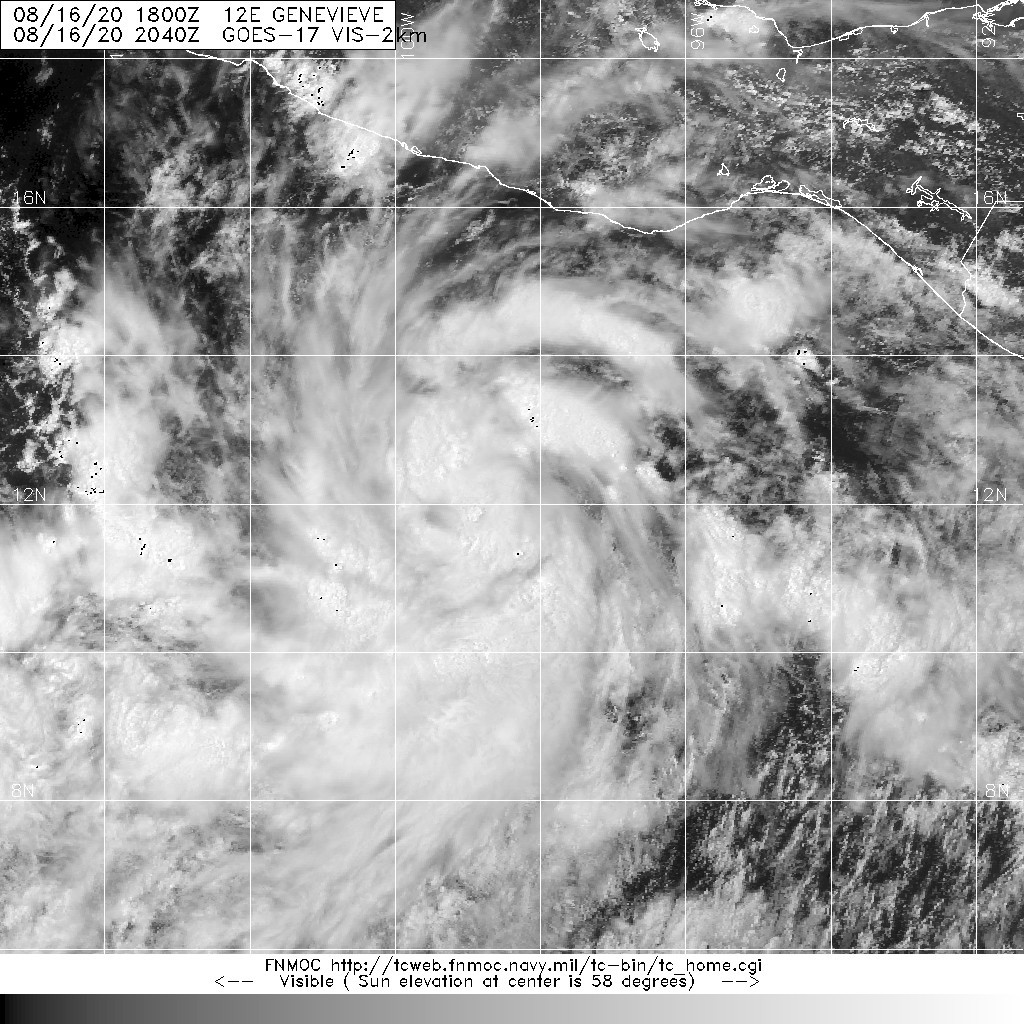
Visible satellite imagery shows that the tropical cyclone is quickly
becoming better organized.  Several bands of deep convection are
located around the center, and there is a concentration of
convection near the estimated center, suggesting that a CDO may
already be starting to form.  The various satellite intensity
estimates were around 35 kt at 18z, and an earlier ASCAT overpass
revealed a couple of wind vectors slightly higher than that value.
Based on the continued increase in organization, the advisory
intensity has been set at 40 kt.  Genevieve becomes the seventh
named storm in the eastern Pacific basin this hurricane season.

Although there are a few dry slots noted within the bands of deep
convection, environmental conditions of warm water, low shear, and
plenty of low- to mid-level moisture along the forecast track
suggest that Genevieve will intensify quite rapidly over the next
couple of days.  The statistical and dynamical guidance, along with
the global models, deepen the cyclone rapidly over the next 2-3
days.  The latest SHIPS Rapid Intensification Index shows about a
65-percent chance of 65-kt increase in wind speed over the next 72
hours, and DTOPS gives a 90-percent chance of a similar increase in
intensity over that same time period.  All of this leads to an
unusually high level of confidence that Genevieve will rapidly
strengthen, likely becoming a hurricane in 24 hours and a major
hurricane within 48 hours. The NHC intensity forecast is similar to
both the SHIPS and HFIP corrected consensus models.  After 72 h,
Genevieve is expected to reach cooler waters, and a fairly quick
rate of weakening is forecast after that time.

Recent satellite fixes suggest that the center is located slightly
north of the previous track, but Genevieve's motion remains
west-northwestward at a brisk 17 kt. The track forecast philosophy
is unchanged from before.  Genevieve should move west-northwestward
to the south of a deep layer ridge over the western United States
during the next couple of days.  After that time, the cyclone will
be approaching the western portion of the ridge and a slightly
slower northwestward motion is expected.  The new NHC track forecast
is slightly north of the previous advisory through 24 hours due to
the more northward initial position, otherwise the updated forecast
is similar to the previous advisory, and is close to the HFIP
corrected consensus model.

Although the tropical cyclone is forecast to remain well offshore
the southern coast of Mexico, large swells generated by the
strengthening system are expected to begin affecting portions of
the coast of southern Mexico over the next day or so.


FORECAST POSITIONS AND MAX WINDS

INIT  16/2100Z 12.2N  99.2W   40 KT  45 MPH
12H  17/0600Z 12.9N 101.5W   50 KT  60 MPH
24H  17/1800Z 14.3N 104.5W   65 KT  75 MPH
36H  18/0600Z 15.7N 107.2W   85 KT 100 MPH
48H  18/1800Z 17.2N 109.3W  100 KT 115 MPH
60H  19/0600Z 18.6N 110.9W  110 KT 125 MPH
72H  19/1800Z 20.2N 112.4W  105 KT 120 MPH
96H  20/1800Z 22.5N 115.3W   80 KT  90 MPH
120H  21/1800Z 24.7N 119.1W   55 KT  65 MPH

$$
Forecaster Brown
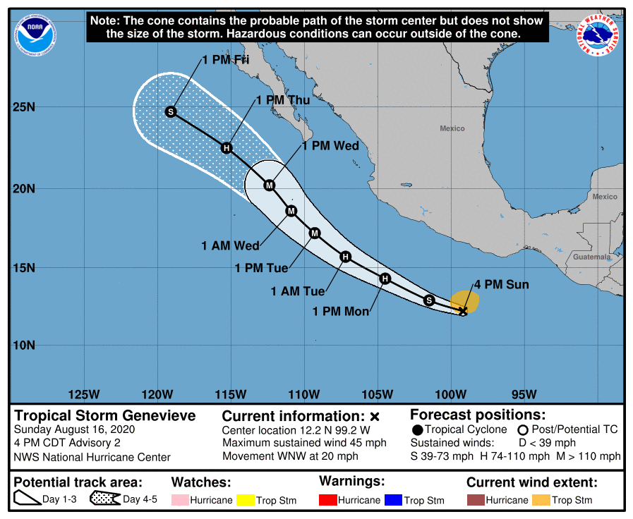
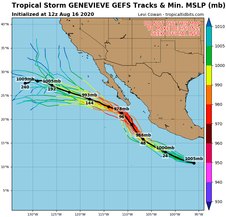
203855_5day_cone_with_line_and_wind.png 12E_gefs_latest.png
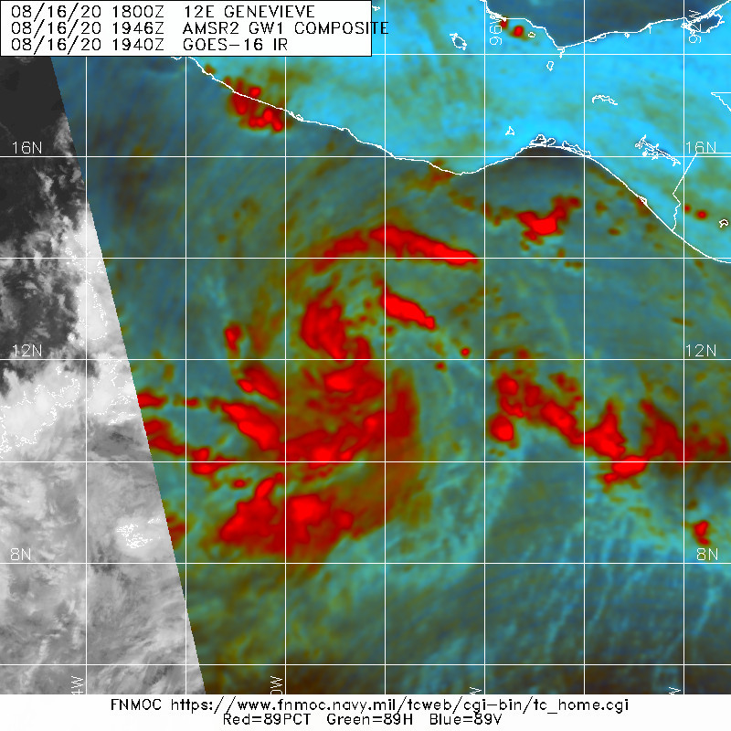
20200816.2040.goes-17.vis.2km.12E.GENEVIEVE.35kts.1004mb.11.9N.98.4W.pc.jpg 20200816.1946.gw1.89pct89h89v.12E.GENEVIEVE.35kts.1004mb.11.9N.98.4W.83pc.jpg
回復

使用道具 舉報

123下一頁
快速回覆
您需要登錄後才可以回帖 登錄 | 立即加入

本版積分規則

霧峰追風者

    主題

    帖子

    221萬

    積分

    16級[四級颶風]

    Rank: 16Rank: 16Rank: 16Rank: 16

16級[四級颶風]

發訊息

本平台僅供學術討論之用,預報應以氣象局為準

威普網站虛擬主機贊助公司

臺灣第一個天氣類型社群平台 即時天氣資訊、精準颱風動態

線上客服
FB傳送訊息
廣告行銷
精準行銷 物超所值
官方粉專
發佈 快速回復 返回頂部 返回列表