開啟輔助訪問
 找回密碼
 立即加入

17L.Paulette 高緯南落 冷心轉暖重回TS

簽到天數: 1650 天

[LV.Master]伴壇終老

老農民版夜神月|2020-9-13 00:45 | 顯示全部樓層
15Z新報定強達TS上限,60KT
NHC於新報中上調上望至95KT,有機會達標MH
al172020.20200912154423.gif PAULETTE.png
20200912.1610.goes-16.vis.2km.17L.PAULETTE.60kts.987mb.27.3N.56.7W.pc.jpg GOES162020202560agb6B.jpg

回復

使用道具 舉報

簽到天數: 53 天

[LV.5]常住居民I

天篷大元帥|2020-9-13 10:45 | 顯示全部樓層
經飛機實測確認增強為颶風
颶風警告稍早在百慕達生效
原文:
ZCZC MIATCDAT2 ALL
TTAA00 KNHC DDHHMM

Hurricane Paulette Discussion Number  25
NWS National Hurricane Center Miami FL       AL172020
1100 PM AST Sat Sep 12 2020

An Air Force Reserve Hurricane Hunter aircraft made multiple passes
through the center of Paulette earlier this evening. The plane
reported max 850-mb flight-level winds of 78 kt and believable SFMR
winds of 58 kt. A dropsonde in the southeast quadrant measured
adjusted mean boundary layer winds of just over 60 kt while multiple
center drops revealed that the minimum pressure is now down to 981
mb. Taken together, these observations support an intensity of 65
kt, making Paulette the 6th hurricane of the 2020 Atlantic season.


The plane found the Paulette has turned west-northwestward and is
nearly exactly on the previous forecast track. With no major changes
in the track guidance either, there is no reason to make any changes
of note to the previous NHC track forecast at this time. A mid-level
ridge building to the north of Paulette should keep the hurricane
moving generally west-northwestward for the next day or so. The
ridge and a mid-level trough to the west should then slide eastward
by early Monday, causing Paulette to slow and turn northward, moving
very near or over Bermuda Monday morning. Paulette is then forecast
to turn northeastward and accelerate in that direction by Tuesday.
The NHC forecast remains in the middle of the tightly clustered
guidance suite at all forecast hours.

Paulette appears to be getting more vertically aligned as the shear
that has affected the cyclone for the past several days slowly
decreases. Further intensification appears likely through early
Monday given the warm SSTs below Paulette and favorable upper-air
environment that is expected to develop around the cyclone. Dry air
in the surrounding environment could be a limiting factor, but all
of the intensity guidance continues to indicate that Paulette will
be a dangerous hurricane when it approaches Bermuda late Sunday and
early Monday. Further intensification will then be possible for
another day or so after the hurricane begins to move away from
Bermuda and it could be near major hurricane strength by the middle
of next week. The NHC intensity forecast is near the middle of the
latest intensity guidance throughout the forecast period.


Key Messages:

1. Paulette is expected to approach Bermuda as a hurricane on Sunday
and will be near the island Sunday night and Monday.  A prolonged
period of strong winds, storm surge, and heavy rainfall is expected
on Bermuda beginning Sunday evening, and a hurricane warning is in
effect for the island
.  Preparations to protect life and property
should be rushed to completion.

2. Swells produced by Paulette are affecting portions of the
Leeward Islands, the Greater Antilles, the Bahamas, Bermuda, and
the east coast of the United States. These swells could cause
life-threatening surf and rip current conditions.


FORECAST POSITIONS AND MAX WINDS

INIT  13/0300Z 28.9N  59.7W   65 KT  75 MPH
12H  13/1200Z 29.7N  61.6W   70 KT  80 MPH
24H  14/0000Z 31.0N  63.8W   80 KT  90 MPH
36H  14/1200Z 32.6N  65.0W   85 KT 100 MPH
48H  15/0000Z 34.5N  64.0W   90 KT 105 MPH
60H  15/1200Z 36.2N  61.0W   95 KT 110 MPH
72H  16/0000Z 37.7N  57.5W   95 KT 110 MPH
96H  17/0000Z 41.0N  49.0W   85 KT 100 MPH
120H  18/0000Z 43.5N  42.0W   70 KT  80 MPH

$$
Forecaster Zelinsky

NNNN


機器翻譯(翻譯粗劣僅供參考):
ZCZC MIATCDAT2 ALL
TTAA00 KNHC DDHHMM

颶風保萊特討論區編號25
NWS國家颶風中心邁阿密FL AL172020
1100 PM AST 2020年9月12日星期六

空軍預備役颶風獵人飛機
今晚早些時候多次穿過保萊特中心。這架飛機
報告的最大飛行高度風為850-mb,風速為78海裡,而SFMR
風為58海裡。東南象限中的一個探空儀測得的
經調整的平均邊界層風剛好超過60 kt,而多次
中心降落表明最低壓力現在降至981
mb。綜上所述,這些觀察結果支持強度為65
kt,使Paulette成為2020年大西洋季節的第六場颶風


飛機發現波萊特(Paulette)已向西北偏西轉,
幾乎正好在先前的預報軌道上。
跟踪指南也沒有重大變化,因此也沒有理由
在此之前對以前的NHC跟踪預測進行任何更改。
保萊特(Paulette)北部的中層山脊建築應使颶風
在第二天左右大致向西北偏西移動。然後,
山脊和向西的中層低谷應
在周一早些時候向東滑動,導致保萊特放慢速度並向北轉,
星期一早上非常接近或越過百慕大。然後預測保萊特
向東北轉,並在星期二朝那個方向加速。
NHC預測
在所有預測時間都位於緊密結合的指導套件的中間。
隨著過去幾天影響旋風分離器

的剪切力逐漸
降低,Paulette似乎越來越垂直對齊。
由於保萊特(Palette)下方的SST溫暖
,並且預計旋風附近將形成有利的高空環境,因此可能在周一初進一步加劇。
周圍環境中的干燥空氣可能是一個限制因素,但所有
強度指南仍表明,保萊特
在星期日晚些時候到達百慕大和在百慕大時將是危險的颶風。
星期一早。
在颶風開始從
百慕大轉移後的另一天左右,可能還會進一步加劇,到
下周中旬可能接近主要颶風強度。在
整個預測期內,NHC強度預報接近最新強度指南的中間值。


重要信息:

1.保萊特預計將在周日作為颶風襲擊百慕大
,並將在周日晚上和周一在島附近。
從周日晚上開始,
預計百慕大將出現長時間的強風,風暴潮和大雨,並且
該島也受到颶風警告
。保護生命和財產的準備
應該趕緊完成。

2.保萊特(Paulette)產生的海浪正在影響
背風群島,大安的列斯群島,巴哈馬,百慕大和
美國東海岸的部分地區。這些膨脹可能會導致
危及生命的海浪和翻滾電流狀況。


預測位置和最大

風速初始化13 / 0300Z 28.9N 59.7W 65 KT 75 MPH
12H 13 / 1200Z 29.7N 61.6W 70 KT 80 MPH
24H 14 / 0000Z 31.0N 63.8W 80 KT 90 MPH
36H 14 / 1200Z 32.6N 65.0W 85 KT 100 MPH
48H 15 / 0000Z 34.5N 64.0W 90 KT 105 MPH
60H 15 / 1200Z 36.2N 61.0W 95 KT 110 MPH
72H 16 / 0000Z 37.7N 57.5W 95 KT 110 MPH
96H 17 / 0000Z 41.0N 49.0W 85 KT 100 MPH
120H 18 / 0000Z 43.5N 42.0W 70 KT 80 MPH

$$
預報員Zelinsky

NNNN

颶風警告.png
回復

使用道具 舉報

簽到天數: 1650 天

[LV.Master]伴壇終老

老農民版夜神月|2020-9-14 01:18 | 顯示全部樓層
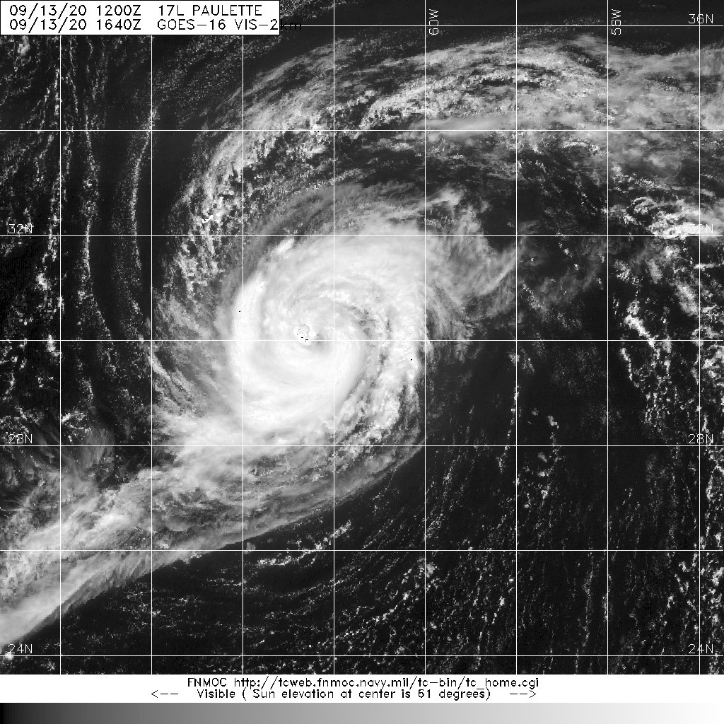
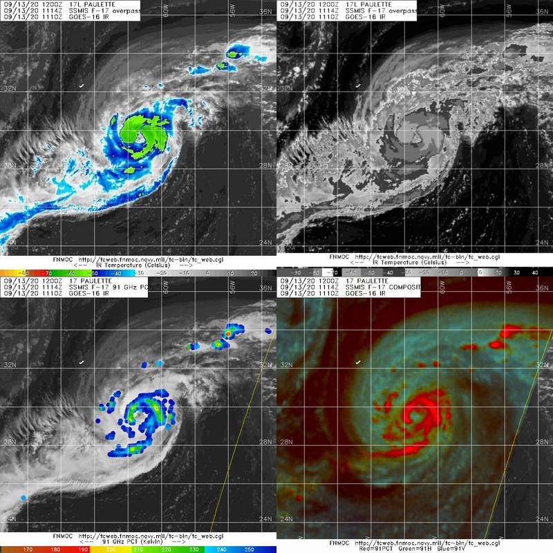
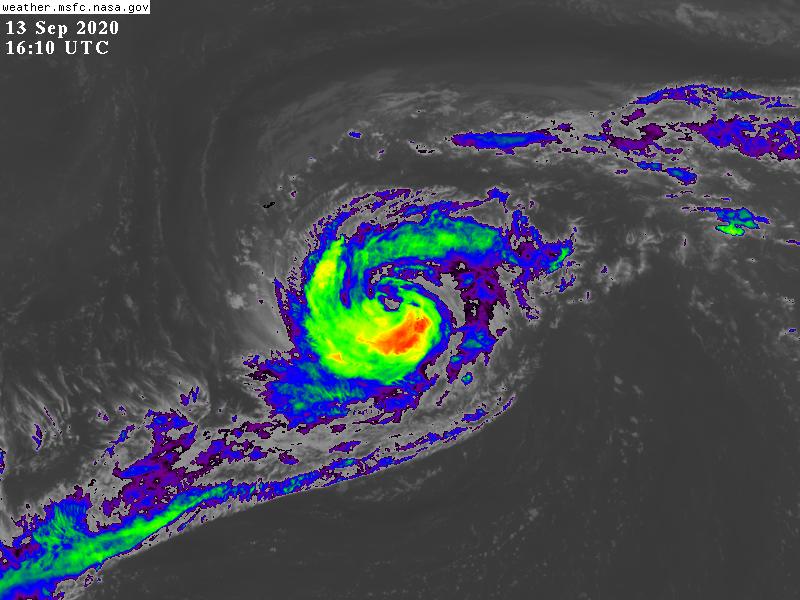
Pauiette結構持續轉好,風眼隱現
NHC新報正式上調上望至MH,100KT
409
WTNT42 KNHC 131450
TCDAT2

Hurricane Paulette Discussion Number  27
NWS National Hurricane Center Miami FL       AL172020
1100 AM AST Sun Sep 13 2020

An Air Force Hurricane Hunter aircraft investigating Paulette this
morning found peak 700-mb flight-level winds of 92 kt, which reduces
to around 75 kt at the surface. However, around that same time the
peak winds measured by the SFMR instrument on board the aircraft
were only 58 kt. It is possible that the stronger winds suggested by
the flight-level values were not reaching the surface at that
location. Later on in the flight, the SFMR measured 64-kt winds in
the northwestern quadrant. Since there has been no notable change to
the structure of the hurricane since the aircraft was in the system
a few hours ago, the initial intensity is being held at 70 kt and is
a compromise of those two different peak values measured by the
aircraft.

Infrared satellite imagery has been showing some dry air intrusion
over the eastern portion of the circulation, causing a break in the
eyewall there over the past few hours. There is currently deep
convection firing around the remainder of the eyewall, and therefore
it is anticipated the dry air will be worked out of the system soon.
Very low wind shear and warm waters will support strengthening over
the next couple of days, and Paulette is expected to be a dangerous
hurricane as it nears Bermuda Monday morning. The window for
strengthening should continue for another 12-24 h after the cyclone
passes Bermuda, and Paulette could become a major hurricane during
that time. After 48 h, vertical wind shear is forecast to rapidly
increase. After 72 h, Paulette is expected to cross the 26 degree C
SST isotherm, and by 120 h those SSTs will be near 22 degrees C.
The NHC forecast shows a weakening trend beginning after 48 h due to
the negative environmental factors. By 120 h, the global models
suggest that Paulette will have completed a transition to an
extratropical cyclone.  The only change to the NHC intensity
forecast from the previous advisory was a slight upward adjustment
over the first few days due to the increase in strength found by
the aircraft this morning. This forecast is in between the LGEM and
HFIP corrected consensus, HCCA.

Paulette is now moving northwestward at 12 kt, to the southwest of a
mid-level ridge. This motion should continue until just after the
cyclone passes Bermuda. Later on Monday, the hurricane should turn
north, then on Monday night northeastward, as it rounds the
periphery of the ridge. After turning northeastward, the cyclone
is expected to accelerate as it gets picked up in the mid-latitude
flow ahead of an approaching mid- to upper-level trough. Later on
in the forecast period, a slower eastward motion is indicated once
the aforementioned trough bypasses the cyclone. The latest NHC
forecast track is little changed from the previous one through 48 h
and lies in the middle of the latest global and regional track
model guidance. Beyond 48 h, the NHC forecast is a little faster
than the previous one, and lies near the tightly clustered consensus
track guidance. On the forecast track, tropical storm conditions
should reach Bermuda by this evening, with hurricane force winds
arriving there overnight.  

Key Messages:

1. Paulette is expected to approach Bermuda as a hurricane today
and will be near the island tonight and Monday.  A prolonged
period of strong winds, storm surge, and heavy rainfall is expected
on Bermuda beginning this evening, and a hurricane warning is in
effect for the island.  Preparations to protect life and property
should be rushed to completion.

2. Swells produced by Paulette are affecting portions of the
Leeward Islands, the Greater Antilles, the Bahamas, Bermuda, and
the east coast of the United States. These swells could cause
life-threatening surf and rip current conditions.


FORECAST POSITIONS AND MAX WINDS

INIT  13/1500Z 29.9N  61.9W   70 KT  80 MPH
12H  14/0000Z 30.9N  63.6W   80 KT  90 MPH
24H  14/1200Z 32.8N  64.8W   90 KT 105 MPH
36H  15/0000Z 35.0N  63.5W   95 KT 110 MPH
48H  15/1200Z 37.0N  60.0W  100 KT 115 MPH
60H  16/0000Z 39.1N  55.1W   95 KT 110 MPH
72H  16/1200Z 41.4N  49.1W   85 KT 100 MPH
96H  17/1200Z 43.9N  42.0W   65 KT  75 MPH
120H  18/1200Z 44.0N  36.6W   50 KT  60 MPH...POST-TROP/EXTRATROP

$$
Forecaster Latto
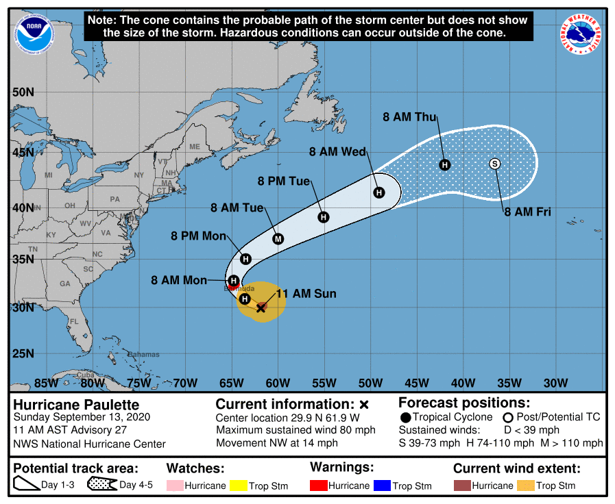
150001_5day_cone_no_line_and_wind.png 20200913.1640.goes-16.vis.2km.17L.PAULETTE.70kts.976mb.29.6N.61.4W.pc.jpg
20200913.1114.f17.composite.17L.PAULETTE.70kts.976mb.29.6N.61.4W.090pc.jpg GOES16102020257rSj4g8.jpg
回復

使用道具 舉報

簽到天數: 1650 天

[LV.Master]伴壇終老

老農民版夜神月|2020-9-15 01:56 | 顯示全部樓層
15Z升格C2,再上調上望至110KT,有望C4
ZCZC MIATCDAT2 ALL
TTAA00 KNHC DDHHMM

Hurricane Paulette Discussion Number  31
NWS National Hurricane Center Miami FL       AL172020
1100 AM AST Mon Sep 14 2020

The 53rd Air Force Reserve hurricane hunter aircraft observed a
peak 700 mb flight-level wind of 93 kt and a SFMR wind of 80 kt 25
miles to the northeast of the center of the 35 mile wide eye.  The
central pressure, also reported by the aircraft, has fallen to 970
mb.  Based on these data, the initial intensity is increased to 85
kt for this advisory.

Additional strengthening is expected as Paulette moves away from
Bermuda and accelerates northeastward over the North Atlantic.  
Paulette should be at or near major hurricane strength within the
next 24 hours.  At the 48 hour forecast period, weakening will
commence as the cyclone becomes involved with a mid-latitude
shortwave trough approaching from the Canadian Maritimes.  Paulette
should begin losing its tropical characteristics toward the end of
the week. The peak intensity is increased a little at the 24 hour
period to agree with the HCCA and IVCN intensity multi-models and
follows these aids through the remaining portion of the forecast
period.

The initial motion estimate is 355/12 kt.  Paulette will begin
accelerating northeastward by Tuesday morning then turn
east-northeastward with a further increased in forward motion early
Wednesday morning.  A slower eastward to southeastward motion is
forecast on Friday in response to a larger mid- to upper
tropospheric cut-off low approaching the eastern Atlantic.  The NHC
forecast is a little faster than the previous one beyond the 36
hour period and basically lies down the middle of the tightly
clustered deterministic and regional model guidance.

Key Messages:

1. The eye of Paulette will gradually move away from Bermuda
today, however, hurricane and tropical storm conditions, storm
surge, and very heavy rainfall will likely continue into this
afternoon.

2. Swells produced by Paulette are affecting portions of the
Leeward Islands, the Greater Antilles, the Bahamas, Bermuda, and
the east coast of the United States. These swells could cause
life-threatening surf and rip current conditions.


FORECAST POSITIONS AND MAX WINDS

INIT  14/1500Z 33.4N  64.7W   85 KT 100 MPH
12H  15/0000Z 35.1N  63.6W   95 KT 110 MPH
24H  15/1200Z 37.5N  59.8W  110 KT 125 MPH
36H  16/0000Z 40.1N  54.2W  110 KT 125 MPH
48H  16/1200Z 42.9N  47.6W   90 KT 105 MPH
60H  17/0000Z 45.5N  41.1W   75 KT  85 MPH
72H  17/1200Z 47.1N  36.8W   65 KT  75 MPH
96H  18/1200Z 45.5N  33.2W   50 KT  60 MPH
120H  19/1200Z 40.1N  32.1W   45 KT  50 MPH...POST-TROP/EXTRATROP

$$
Forecaster Roberts

NNNN
al172020.20200914155233.gif 20200914.1710.goes-16.vis.2km.17L.PAULETTE.85kts.970mb.32.9N.64.9W.pc.jpg
GOES17402020258MGvh0v.jpg goes16_vis_17L_202009141515.gif
回復

使用道具 舉報

簽到天數: 1650 天

[LV.Master]伴壇終老

老農民版夜神月|2020-9-16 00:43 | 顯示全部樓層
緯度漸高,風眼堵塞,可能已達巔峰
INIT  15/1500Z 38.3N  57.9W   90 KT 105 MPH
12H  16/0000Z 40.1N  53.6W   95 KT 110 MPH
24H  16/1200Z 42.7N  46.8W   85 KT 100 MPH
36H  17/0000Z 45.0N  40.1W   70 KT  80 MPH
48H  17/1200Z 46.2N  35.7W   55 KT  65 MPH...POST-TROP/EXTRATROP
60H  18/0000Z 45.6N  33.9W   45 KT  50 MPH...POST-TROP/EXTRATROP
72H  18/1200Z 43.9N  33.3W   40 KT  45 MPH...POST-TROP/EXTRATROP
96H  19/1200Z 39.9N  32.2W   35 KT  40 MPH...POST-TROP/EXTRATROP
120H  20/1200Z 37.0N  31.5W   35 KT  40 MPH...POST-TROP/EXTRATROP
20200915.1610.goes-16.vis.2km.17L.PAULETTE.90kts.965mb.37.7N.59.3W.pc.jpg 20200915.1045.f17.91pct91h91v.17L.PAULETTE.90kts.965mb.36.3N.61.7W.070pc.jpg
GOES16202020259xIDS8D.jpg 20200915.1045.f17.91hw.17L.PAULETTE.90kts.965mb.36.3N.61.7W.070pc.jpg
回復

使用道具 舉報

簽到天數: 1650 天

[LV.Master]伴壇終老

老農民版夜神月|2020-9-17 00:49 | 顯示全部樓層
判定於15Z轉溫帶氣旋
ZCZC MIATCDAT2 ALL
TTAA00 KNHC DDHHMM

Post-Tropical Cyclone Paulette Discussion Number  39
NWS National Hurricane Center Miami FL       AL172020
1100 AM AST Wed Sep 16 2020

Conventional GOES-16 visible and enhanced BD-curve satellite imagery
show that Paulette has merged with the large baroclinic zone
extending over the north-central Atlantic.  Deep convection just to
the north of the surface center that was noted on earlier microwave
images has dissipated.  Therefore, the system is now classified as
extratropical cyclone and this is the last NHC advisory. The initial
intensity is conservatively lowered to 75 kt based on 1221 UTC
scatterometer data, earlier Dvorak intensity estimates and a SATCON
analysis of 64 kt.

The NHC intensity forecast is based on a blend of the global models
and is just above the HCCA multi-model consensus. Although not
specified in the NHC forecast, there is some chance that Paulette
could reacquire tropical or subtropical characteristics later this
week or over the weekend when it turns southward back over warmer
oceanic temperatures. This possibility will be monitored for
inclusion in future Tropical Weather Outlooks, if necessary.

The post-tropical cyclone's initial motion is east-northeastward,
or 060/30 kt. The low is expected to continue quickly in this
general motion through Thursday morning within the deep-layer
mid-latitude flow.  By mid-period, Post-Tropical Paulette is
expected to slow down and turn southeastward to southward as it
moves on the west side of mid- to upper-level low to the east of the
cyclone.  The new track forecast is based primarily on the HCCA and
TVCA consensus aids.

Paulette is producing a large area of high seas.  The maximum seas
estimated by the Ocean Prediction Center near the core of the
hurricane are up to 50 feet.  Swells from Post-Tropical Cyclone
Paulette have spread far away from the center and continue to affect
Atlantic Canada, Bermuda, and portions of the U.S. east coast.

This is the last NHC advisory on Paulette. Additional information
on this system can be found in High Seas Forecasts issued by the
National Weather Service, under AWIPS header NFDHSFAT1, WMO header
FZNT01 KWBC, and online at ocean.weather.gov/shtml/NFDHSFAT1.php

FORECAST POSITIONS AND MAX WINDS

INIT  16/1500Z 43.3N  45.2W   75 KT  85 MPH...POST-TROP/EXTRATROP
12H  17/0000Z 45.0N  39.9W   60 KT  70 MPH...POST-TROP/EXTRATROP
24H  17/1200Z 46.2N  35.3W   50 KT  60 MPH...POST-TROP/EXTRATROP
36H  18/0000Z 45.1N  33.1W   40 KT  45 MPH...POST-TROP/EXTRATROP
48H  18/1200Z 42.5N  32.5W   35 KT  40 MPH...POST-TROP/EXTRATROP
60H  19/0000Z 39.5N  32.5W   35 KT  40 MPH...POST-TROP/EXTRATROP
72H  19/1200Z 37.0N  32.7W   35 KT  40 MPH...POST-TROP/EXTRATROP
96H  20/1200Z 35.0N  32.9W   35 KT  40 MPH...POST-TROP/EXTRATROP
120H  21/1200Z 34.0N  32.4W   35 KT  40 MPH...POST-TROP/EXTRATROP

$$
Forecaster Roberts

NNNN
152343_5day_cone_no_line_and_wind.png al172020.20200916153148.gif
20200916.1550.goes-16.vis.2km.17L.PAULETTE.75kts.973mb.42.6N.46.9W.pc.jpg GOES161020202605324Ig.jpg
回復

使用道具 舉報

簽到天數: 1650 天

[LV.Master]伴壇終老

老農民版夜神月|2020-9-18 14:57 | 顯示全部樓層
NHC重新展望10%,後期有南落後轉暖的可能
3. Post-tropical cyclone Paulette is located several hundred miles
north-northwest of the Azores. The cyclone is forecast to move
quickly southward for the next several days and then stall over
marginally warm waters a few hundred miles south or south-southwest
of the Azores by the end of the weekend. The cyclone could
subsequently redevelop tropical characteristics late this weekend or
early next week while it moves little.
* Formation chance through 48 hours...low...10 percent.
* Formation chance through 5 days...low...20 percent.
two_atl_2d3.png two_atl_5d3.png 20200918.0620.goes-16.ir.17L.PAULETTE.45kts.986mb.44.6N.31.4W.100pc.jpg
回復

使用道具 舉報

簽到天數: 3279 天

[LV.Master]伴壇終老

t02436|2020-9-19 13:33 | 顯示全部樓層
持續南下,展望已提升至40%
1. Post-Tropical Cyclone Paulette is moving southward and is now
located just south of the western Azores. The cyclone is forecast to
continue southward for the next day or two and then stall over
marginally warm waters a few hundred miles south of the Azores. The
cyclone could subsequently develop tropical or subtropical
characteristics by early next week while it moves little. For more
information about marine hazards associated with this system, see
High Seas Forecasts issued by Meteo France.
* Formation chance through 48 hours...medium...40 percent.
* Formation chance through 5 days...medium...50 percent.

two_atl_2d1.png
two_atl_5d1.png

ab2aebc7-2270-41c9-b3c9-b6db88421d5d.jpg

17L_gefs_latest.png
回復

使用道具 舉報

快速回覆
您需要登錄後才可以回帖 登錄 | 立即加入

本版積分規則

本平台僅供學術討論之用,預報應以氣象局為準

威普網站虛擬主機贊助公司

臺灣第一個天氣類型社群平台 即時天氣資訊、精準颱風動態

線上客服
FB傳送訊息
廣告行銷
精準行銷 物超所值
官方粉專
發佈 快速回復 返回頂部 返回列表