開啟輔助訪問
 找回密碼
 立即加入

98S 一度發布TCFA 無緣升格

簽到天數: 1650 天

[LV.Master]伴壇終老

2021-3-25 18:03 | 顯示全部樓層
  熱帶低壓  
編號:15-20202021 ( 98 S )
名稱:

  基本資料     
擾動編號日期:2021 03 25 17
撤編日期  :2021 03 31 00
登陸地點  :


  巔峰時期資料  
近中心最強風速
法國留尼旺氣象局 (MFR) :30 kt
聯合颱風警報中心(JTWC):30 kt ( TD )
海平面最低氣壓998 百帕

  擾動編號資料  

98S.INVEST.15kts.996mb.7.8S.63.8E
20210325.0930.himawari-8.ir.98S.INVEST.15kts.996mb.7.8S.63.8E.090pc.jpg
以上資料來自:MFR、JTWC、颱風論壇整理製作

評分

參與人數 1水氣能量 +15 +1 收起 理由
s6815711 + 15 + 1

查看全部評分

回復

使用道具 舉報

簽到天數: 1650 天

[LV.Master]伴壇終老

老農民版夜神月|2021-3-26 02:53 | 顯示全部樓層
JTWC18Z略微提升定強至20節,GFS部分系集支持發展
98S INVEST 210325 1800 8.4S 64.7E SHEM 20 1005
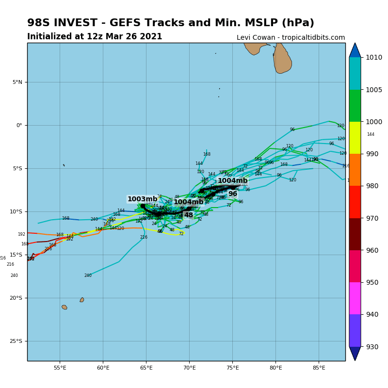
20210325.1438.f17.91pct91h91v.98S.INVEST.15kts.1010mb.8S.64E.085pc.jpg 20210325.1438.f17.91h.98S.INVEST.15kts.1010mb.8S.64E.085pc.jpg LATEST - 2021-03-26T025202.128.jpg 98S_gefs_latest (5).png
回復

使用道具 舉報

簽到天數: 483 天

[LV.9]以壇為家II

dom|2021-3-26 12:07 | 顯示全部樓層
JTWC評級low
  (2) AN AREA OF CONVECTION (INVEST 98S) HAS PERSISTED NEAR 8.3S
64.7E, APPROXIMATELY 466 NM WEST-SOUTHWEST OF DIEGO GARCIA. ANIMATED
ENHANCED INFRARED (EIR) IMAGERY AND A 252136Z SSMIS 91GHZ SATELLITE
PARTIAL IMAGE DEPICT FORMATIVE, ALBEIT FRAGMENTED, BANDING WRAPPING
INTO A LOW LEVEL CIRCULATION CENTER THAT IS OBSCURED BY BUILDING
CONVECTION. 98S IS CURRENTLY IN A FAVORABLE ENVIRONMENT WITH
POLEWARD OUTFLOW, WARM (29 TO 30 CELSIUS) SEA SURFACE TEMPERATURES,
AND LOW TO MODERATE (10 TO 20 KNOTS) VERTICAL WIND SHEAR (VWS).
GLOBAL MODELS ARE IN OVERALL DISAGREEMENT. THE SYSTEM IS EXPECTED TO
REMAIN QUASISTATIONARY FOR THE NEXT 24-48 HOURS. MAXIMUM SUSTAINED
SURFACE WINDS ARE ESTIMATED AT 15 TO 20 KNOTS. MINIMUM SEA LEVEL
PRESSURE IS ESTIMATED TO BE NEAR 1005 MB. THE POTENTIAL FOR THE
DEVELOPMENT OF A SIGNIFICANT TROPICAL CYCLONE WITHIN THE NEXT 24
HOURS IS LOW.
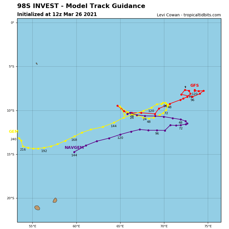
98S_tracks_latest.png 98S_gefs_latest.png
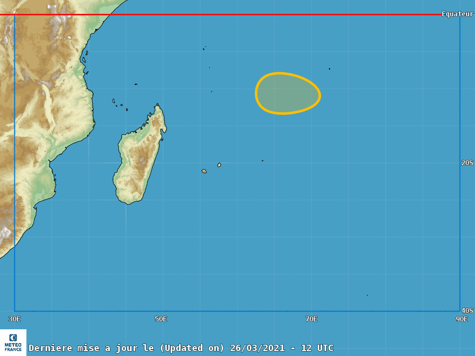
MFR認為發展機會中等
cyclogenese.png

回復

使用道具 舉報

簽到天數: 1650 天

[LV.Master]伴壇終老

老農民版夜神月|2021-3-26 12:51 | 顯示全部樓層
MFR於昨日12Z報文後段提及了查哥斯群島西南的一個系統,據定位而言應即是98S
AWIO21 FMEE 251011
CENTRE DES CYCLONES TROPICAUX / CMRS DE LA REUNION / METEO-FRANCE
BULLETIN SUR L'ACTIVITE CYCLONIQUE ET LES CONDITIONS
METEOROLOGIQUES TROPICALES SUR LE SUD-OUEST DE L'OCEAN INDIEN
LE 25/03/2021 A 1200 UTC
PARTIE 1:
AVIS SPECIAUX EN COURS:
Néant.
PARTIE 2 :
ACTIVITE DANS LE DOMAINE TROPICAL:
Le bassin est en configuration de talweg de mousson (TM) axé entre 8S et 10S à l'Est de 55E.
L'activité convective est modérée à forte sur la face équatoriale de ce TM, mais aussi dans la zone
de ralentissement du flux d'alizé au sud d'une large circulation centrée approximativement vers
8S/65E.
En limite Est du bassin, dans la zone de responsabilité Australienne, la large circulation
dépressionnaire 21U continue d'être suivie par le Bom, via les bulletins IDW10800
En zone australienne :
Localisé vers 11.6S/92.2E par le BoM à 06UTC, le centre de circulation, présentant des vents
maximaux de l'ordre de 25kt dans le secteur Sud-Ouest, pourrait rentrer dans notre zone de
responsabilité à partir de demain Vendredi. Cependant, les conditions environnementales ne
laissent pas vraiment de potentiel d'intensification pour cette circulation au cours des prochains
jours.
Le risque de formation d'une tempête tropicale modérée reste faible à partir de Vendredi sur
l'extrémité Est du bassin.
Au sud-ouest de l'archipel des Chagos :
La passe ASCAT partielle de 0403UTC ne permet pas de définir précisément une circulation fermée
au Sud-Ouest des Chagos dont une localisation vers 7.5S/63.8E pourrait être faite à 0900UTC. Il
faut attendre que cette circulation se consolide au cours des prochains jours pour que le potentiel de
développement soit un peu plus marqué. Ainsi un risque d'atteindre le seuil de tempête tropicale
modérée commence à être notable dans les guidances à partir de 3/4 jours
Le risque de formation d'une tempête tropicale modérée est modéré à partir de Lundi au
sud-ouest de l'archipel des Chagos.

NOTA BENE: La probabilité donnée est une estimation des "chances" de formation d'une tempête
tropicale modérée sur le bassin au cours des 5 prochains jours:
Très faible: inf. à 10% Modérée: 30% à 60% Très importante: sup. à 90%
Faible: 10% à 30% Importante: 60% à 90%
Le bassin du Sud-Ouest de l'Océan Indien s'étend de l'équateur à 40S et des côtes africaines
jusqu'à 90E.
20210326.033000.SH982021.seviri.msg-4.Infrared-Gray.20kts.57p9.1p0.jpg 20210326.014300.SH982021.ssmis.F17.color89.20kts.65p0.1p0.jpg 20210326.014400.SH982021.ssmis.F17.89H.20kts.65p0.1p0.jpg
回復

使用道具 舉報

簽到天數: 483 天

[LV.9]以壇為家II

dom|2021-3-26 14:54 | 顯示全部樓層
JTWC06Z升格TD
98S INVEST 210326 0600 8.7S 64.5E SHEM 25 1003
77E70927-2A5D-47D0-802B-E1754DAC5CFD.jpeg
回復

使用道具 舉報

簽到天數: 1650 天

[LV.Master]伴壇終老

老農民版夜神月|2021-3-27 06:04 | 顯示全部樓層
本帖最後由 老農民版夜神月 於 2021-3-27 06:25 編輯

MFR新報維持此系統發展至中度熱帶風暴以上強度的概率為中
AWIO20 FMEE 261242

TROPICAL CYCLONE CENTER / RSMC LA REUNION / METEO-FRANCE

BULLETIN FOR CYCLONIC ACTIVITY AND SIGNIFICANT TROPICAL WEATHER IN
THE SOUTHWEST INDIAN OCEAN

DATE: 2021/03/26 AT 1200 UTC

PART 1:

WARNING SUMMARY:


Nil.

PART 2 :
TROPICAL WEATHER DISCUSSION:


The basin is in a monsoon trough (MT) configuration between 50 and 75E centered between 8S and 10S. Further east, a Near Equatorial Trough (NET) pattern persists with westerlies just south of the equator. The convective activity is moderate in the flows slowing down area but also near the two suspect areas located east of Agalega and in the Australian AoR.

In the Australian region:

Located near 10.7S/91.0E according to the BoM at 06UTC, the system is still weak given to the latest scatterometer data. The 0833Z SSMI swath shows that the convective activity is shallow near the center.

Despite a good upper level divergence, this minimum is restrained by a moderate westerly shear bringing dry air, and a lack of surface convergence. Indeed, over the next few days, the circulation should progressively lose its equatorial feeding due to the strengthening of the westerlies and their bending towards the northern hemisphere (Kelvin wave + MRG) but also due to the lack of surface convergence on the polar side north of a deep trough. This minimum should disappear in the next few days over the extreme east of our area of responsibility.

Development of a moderate tropical storm over the easternmost parts of our basin is not expected anymore.

East of Agalega:

Thanks to good feeding on the equatorial side (20/25kt monsoon flow) and to a lesser extent on the polar side, the suspect area between Agalega and Diego-Garcia is showing signs of development with increasing curvature in the cloud pattern. Nevertheless, according to partial ASCAT data and high resolution satellite images, it seems that the inner core of the circulation is still quite broad. A swirl of clouds rotating around a center drowned in the convective mass, can be seen around 9.4S/66.6E at 11Z.

This system does not benefit from particularly favorable conditions. Despite a good feeding on the equatorial side, the trade wind flow is weak on the far edge of the subtropical ridge. A weak to moderate easterly shear also seems to limit the potential for development at shorter range. On Sunday, while the trade wind flow is strengthening with the arrival of the new high-pressure cell to the south, the surface convergence on the northern side is weakening, with the westerly flow bending towards the northern hemisphere (Kelvin wave + MRG). Mid next week, on the edge of the NET, the system could find a more conducive environment for its deepening. But for now, the main guidance is now keen to significantly deepen that low, especially those of NOAA. IFS in its last run still suggest gale force winds on Sunday.

The risk of development of a moderate tropical storm, south-west of the Chagos Islands is moderate up to Monday, and then low from Tuesday.
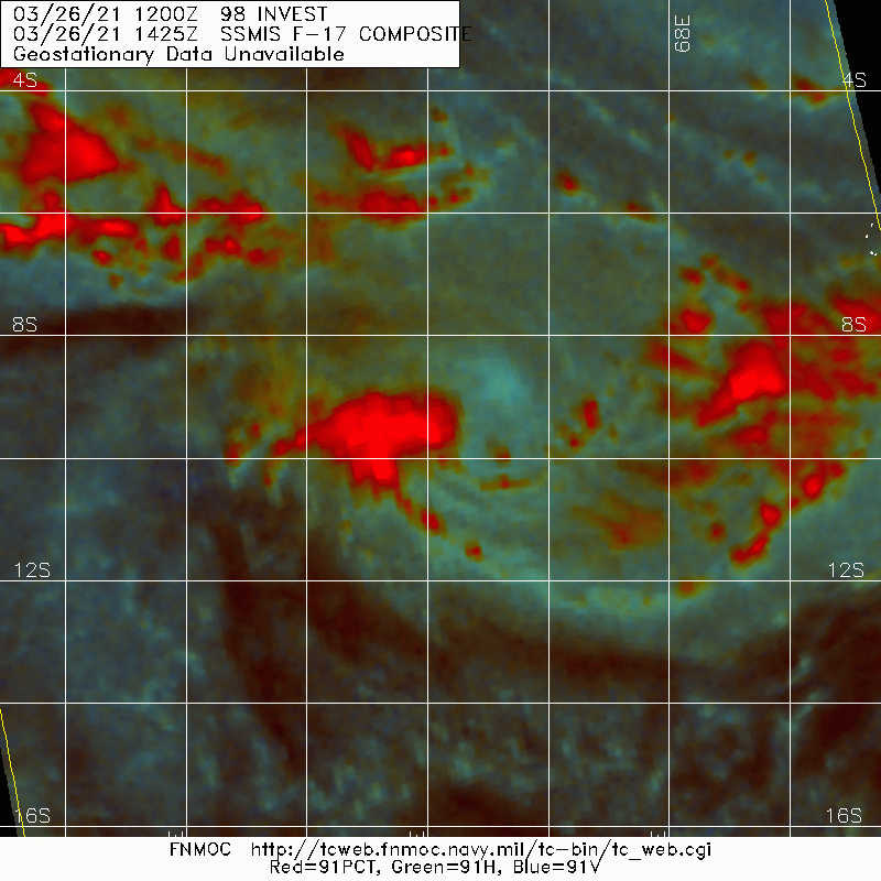
LATEST - 2021-03-27T053117.143.jpg 20210326.1425.f17.91pct91h91v.98S.INVEST.25kts.1003mb.9.7S.64.2E.100pc.jpg
cyclogenese (8).png 98S_tracks_latest (1).png
98S_gefs_latest (6).png
回復

使用道具 舉報

簽到天數: 1650 天

[LV.Master]伴壇終老

老農民版夜神月|2021-3-27 06:23 | 顯示全部樓層
本帖最後由 老農民版夜神月 於 2021-3-27 06:35 編輯

JTWC開始對其進行分析
TPXS11 PGTW 262126

A. TROPICAL DISTURBANCE 98S (W OF DIEGO GARCIA)

B. 26/2045Z

C. 10.25S

D. 65.06E

E. FIVE/GOES-IO

F. T1.0/1.0

G. IR/EIR

H. REMARKS: 38A/PBO SBC/ANMTN. CNVCTN WRAPS .25 ON LOG10 SPIRAL
YIELDING A DT OF 1.0. MET/PT AGREE. DBO DT.

I. ADDITIONAL POSITIONS: NONE


   MARTIN

20210326.204500.SH982021.seviri.msg-1.Infrared-Gray.25kts.100p0.1p0.jpg 20210326.2048.gw1.89pct89h89v.98S.INVEST.25kts.1004mb.9.9S.64.9E.72pc.jpg 20210326.2048.gw1.89hbt.98S.INVEST.25kts.1004mb.9.9S.64.9E.72pc.jpg
回復

使用道具 舉報

簽到天數: 483 天

[LV.9]以壇為家II

dom|2021-3-27 09:11 | 顯示全部樓層
JTWC評級提升至medium
     (2) THE AREA OF CONVECTION (INVEST 98S) PREVIOUSLY LOCATED
NEAR 9.48S 64.55E IS NOW LOCATED NEAR 9.9S 64.9E, APPROXIMATELY 474
NM WEST-SOUTHWEST OF DIEGO GARCIA. ANIMATED EIR IMAGERY AND A
262048Z AMSR2 89GHZ MICROWAVE IMAGE DEPICT FORMATIVE BANDING AND
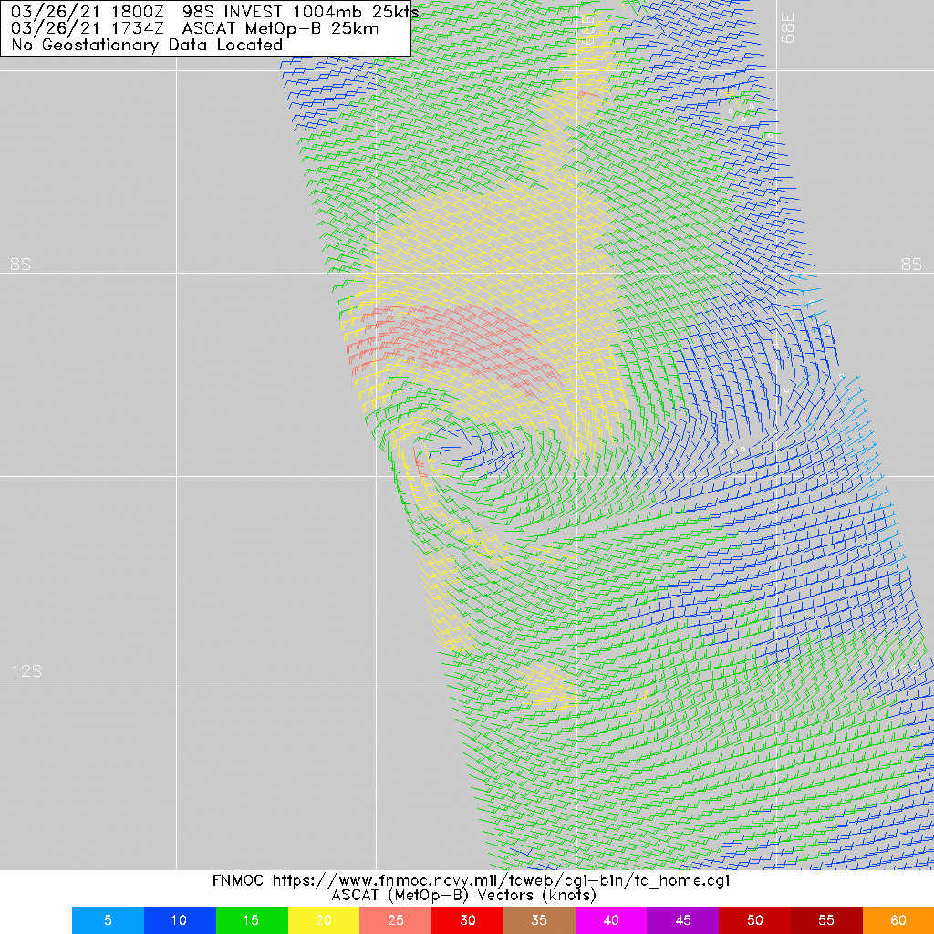
PERSISTENT CONVECTION FLARING NEAR A LLCC. A 261734Z ASCAT-B IMAGE
SHOWS 25-30KT WINDS IN THE NORTHERN PERIPHERY OF A SLIGHTLY
ELONGATED LLCC. 98S IS CURRENTLY IN A FAVORABLE ENVIRONMENT WITH
GOOD POLEWARD OUTFLOW, MODERATE (15 TO 20 KNOTS) VERTICAL WIND SHEAR
(VWS) AND WARM (29 TO 30 CELSIUS) SEA SURFACE TEMPERATURES. GLOBAL
MODELS ARE IN OVERALL DISAGREEMENT OF BOTH TRACK AND POTENTIAL
TROPICAL DEVELOPMENT OVER THE NEXT 24-48 HOURS. MAXIMUM SUSTAINED
SURFACE WINDS ARE ESTIMATED AT 25 TO 30 KNOTS. MINIMUM SEA LEVEL
PRESSURE IS ESTIMATED TO BE NEAR 1002 MB. THE POTENTIAL FOR THE
DEVELOPMENT OF A SIGNIFICANT TROPICAL CYCLONE WITHIN THE NEXT 24
HOURS IS UPGRADED TO MEDIUM.
732C54A8-291A-4E63-8C9D-A128DE1557AD.jpeg
回復

使用道具 舉報

123下一頁
快速回覆
您需要登錄後才可以回帖 登錄 | 立即加入

本版積分規則

本平台僅供學術討論之用,預報應以氣象局為準

威普網站虛擬主機贊助公司

臺灣第一個天氣類型社群平台 即時天氣資訊、精準颱風動態

線上客服
FB傳送訊息
廣告行銷
精準行銷 物超所值
官方粉專
發佈 快速回復 返回頂部 返回列表