開啟輔助訪問
 找回密碼
 立即加入

26S.Seroja 曾增強至澳式C3 登陸澳洲

簽到天數: 483 天

[LV.9]以壇為家II

dom|2021-4-2 21:15 | 顯示全部樓層
JTWC12Z升格TD
99S INVEST 210402 1200 11.0S 122.3E SHEM 25 1002
C20BA6B9-2C3B-4F44-B1FC-6A7301258111.jpeg
回復

使用道具 舉報

簽到天數: 1650 天

[LV.Master]伴壇終老

老農民版夜神月|2021-4-2 22:21 | 顯示全部樓層
GFS對99S的訊號亦逐漸強烈
20210402.1340.himawari-8.ir.99S.INVEST.25kts.1002mb.11S.122.3E.100pc.jpg 99S_tracks_latest (3).png 99S_gefs_latest (6).png
回復

使用道具 舉報

簽到天數: 1650 天

[LV.Master]伴壇終老

老農民版夜神月|2021-4-3 16:43 | 顯示全部樓層
發展日益成熟,稍晚可能就會發布TCFA 20210403.0810.himawari-8.vis.99S.INVEST.25kts.1001mb.11.7S.123E.100pc.jpg LATEST - 2021-04-03T164137.535.jpg
20210403.0743.f15.85rgb.99S.INVEST.25kts.1001mb.11.7S.123E.065pc.jpg 99S_gefs_latest (7).png
回復

使用道具 舉報

簽到天數: 483 天

[LV.9]以壇為家II

dom|2021-4-3 22:36 | 顯示全部樓層
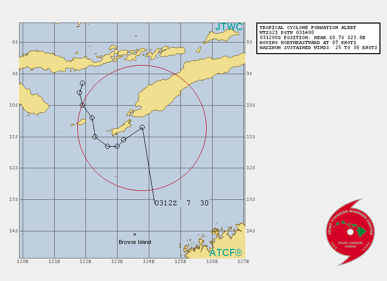
JTWC1400Z發佈TCFA
WTXS21 PGTW 031400
MSGID/GENADMIN/JOINT TYPHOON WRNCEN PEARL HARBOR HI//
SUBJ/TROPICAL CYCLONE FORMATION ALERT (INVEST 99S)//
RMKS/
1. FORMATION OF A SIGNIFICANT TROPICAL CYCLONE IS POSSIBLE WITHIN
080 NM EITHER SIDE OF A LINE FROM 9.9S 124.6E TO 11.3S 122.9E
WITHIN THE NEXT 12 TO 24 HOURS. AVAILABLE DATA DOES NOT JUSTIFY
ISSUANCE OF NUMBERED TROPICAL CYCLONE WARNINGS AT THIS TIME.
WINDS IN THE AREA ARE ESTIMATED TO BE 25 TO 30 KNOTS. METSAT
IMAGERY AT 031200Z INDICATES THAT A CIRCULATION CENTER IS LOCATED
NEAR 10.7S 123.8E. THE SYSTEM IS MOVING NORTHEASTWARD AT 07
KNOTS.
2. REMARKS: THE AREA OF CONVECTION (INVEST 99S) PREVIOUSLY LOCATED
NEAR 11.0S 122.3E IS NOW LOCATED NEAR 10.7S 123.8E, APPROXIMATELY
209 NM NORTH OF BROWSE ISLAND, AUSTRALIA. ANIMATED MULTISPECTRAL
SATELLITE IMAGERY AND A 031054Z SSMIS F-17 91GHZ MICROWAVE IMAGE
DEPICT FLARING DEEP CONVECTION CIRCLING A PARTIALLY OBSCURED LOW
LEVEL CIRCULATION CENTER (LLCC) WITH FRAGMENTED FORMATIVE BANDING
WRAPPING IN FROM THE SOUTH AND EAST. A 031150Z METOP-A ASCAT PASS
REVEALS A TIGHT LLCC WITH A SMALL, BUT ENHANCED, WIND FIELD OF 20 TO
30 KNOTS WITH A COUPLE 35 KNOT WIND BARBS TO THE NORTH. 99S IS
CURRENTLY IN A FAVORABLE ENVIRONMENT WITH WARM (30 CELSIUS) SEA
SURFACE TEMPERATURES, LOW (10 TO 15 KNOT) VERTICAL WIND SHEAR, AND
GOOD RADIAL OUTFLOW. GLOBAL MODELS ARE IN GENERAL AGREEMENT THAT 99S
WILL REMAIN LARGELY QUASISTATIONARY WITH SLIGHTLY NORTHEASTWARD
MOVEMENT BEFORE TURNING 180 DEGREES TO THE SOUTHWEST IN AROUND 18 TO
24 HOURS. IN THAT TIME, 99S WILL CONTINUE TO INTENSIFY; HOWEVER,
MODELS DISAGREE ON TIMING WITH THE MAJORITY PREDICTING 99S REACHING
WARNING THRESHOLD IN APPROXIMATELY 36 HOURS, WHILE ECMWF, THE ONLY
OUTLIER, PREDICTS A QUICKER INTENSIFICATION, REACHING WARNING
THRESHOLD IN 12 TO 24 HOURS. MAXIMUM SUSTAINED SURFACE WINDS ARE
ESTIMATED AT 25 TO 30 KNOTS. MINIMUM SEA LEVEL PRESSURE IS ESTIMATED
TO BE NEAR 1000 MB. THE POTENTIAL FOR THE DEVELOPMENT OF A
SIGNIFICANT TROPICAL CYCLONE WITHIN THE NEXT 24 HOURS IS HIGH.
3. THIS ALERT WILL BE REISSUED, UPGRADED TO WARNING OR CANCELLED BY
041400Z.//
NNNN
D9F61D33-7947-4C1A-AD67-1064DA637503.gif 194FEEF5-6ACE-4EEF-9CFD-120DD2E7196B.jpeg
回復

使用道具 舉報

簽到天數: 483 天

[LV.9]以壇為家II

dom|2021-4-3 22:46 | 顯示全部樓層
最新風場掃描出30KT旗子,BoM預測明後天便有機會將其升格
99S INVEST 210403 1200 10.7S 123.8E SHEM 30 999
A tropical low (22U) lies just to the south of the island of Timor. It is expected to gradually intensify while remaining slow moving well to the north of the Kimberley coast untill Monday. The system will likely develop into a tropical cyclone during Sunday or Monday.
From Monday, 22U is likely to move in a southwesterly direction, roughly parallel to the WA coast. The environment in this area is favourable, and it should continue to develop. It will remain far enough offshore to not directly impact the WA mainland until at least the middle of the week, but people in the north of WA are urged to keep up-to-date with the latest forecasts and warnings.

Likelihood of this system being a tropical cyclone in the Western Region on:
Sunday:Moderate
Monday:High
Tuesday:High
A63C907D-E008-4DC1-A04D-120F810C1ABC.jpeg 1C993238-7C84-40BA-A93E-FC12725D7525.jpeg 3B60882B-153F-460D-A6A8-8B27D090236A.jpeg
回復

使用道具 舉報

簽到天數: 1650 天

[LV.Master]伴壇終老

老農民版夜神月|2021-4-3 23:02 | 顯示全部樓層
本帖最後由 老農民版夜神月 於 2021-4-3 23:03 編輯

雖然預報的路徑略有不同,但EC,GFS均已同樣的對其上望高強度,未來發展可期
ecmwf_z500_mslp_io_8.png 13BEC10A90C5E5690B75EDC74C36DCF4.jpg
99S_gefs_latest (8).png
回復

使用道具 舉報

簽到天數: 483 天

[LV.9]以壇為家II

dom|2021-4-4 08:32 | 顯示全部樓層
本帖最後由 dom 於 2021-4-4 15:04 編輯

BoM初報上望澳式C3, 80KT
IDW27600
TROPICAL CYCLONE TECHNICAL BULLETIN: AUSTRALIA - WESTERN REGION
Issued by AUSTRALIAN BUREAU OF METEOROLOGY TROPICAL CYCLONE WARNING CENTRE
at: 0234 UTC 04/04/2021
Name: Tropical Low  
Identifier: 22U
Data At: 0000 UTC
Latitude: 10.6S
Longitude: 123.6E
Location Accuracy: within 45 nm [85 km]
Movement Towards: northeast [044 deg]
Speed of Movement: 1 knots [3 km/h]
Maximum 10-Minute Wind: 30 knots [55 km/h]
Maximum 3-Second Wind Gust: 45 knots [85 km/h]
Central Pressure: 996 hPa
Radius of 34-knot winds NE quadrant:   
Radius of 34-knot winds SE quadrant:   
Radius of 34-knot winds SW quadrant:   
Radius of 34-knot winds NW quadrant:   
Radius of 48-knot winds NE quadrant:   
Radius of 48-knot winds SE quadrant:   
Radius of 48-knot winds SW quadrant:   
Radius of 48-knot winds NW quadrant:   
Radius of 64-knot winds:
Radius of Maximum Winds:   
Dvorak Intensity Code: T2.0/2.0/D0.5/24HRS STT:D0.5/3HRS
Pressure of outermost isobar: 1002 hPa
Radius of outermost closed isobar: 110 nm [205 km]
FORECAST DATA
Date/Time    : Location    : Loc. Accuracy: Max Wind   : Central Pressure
[UTC]        : degrees     :      nm  [km]: knots[km/h]: hPa
+06:  04/0600: 10.5S 123.6E:     060 [115]:  035  [065]:  993
+12:  04/1200: 10.4S 123.4E:     065 [120]:  035  [065]:  992
+18:  04/1800: 10.5S 123.2E:     065 [125]:  040  [075]:  990
+24:  05/0000: 10.7S 122.8E:     065 [120]:  045  [085]:  990
+36:  05/1200: 11.3S 121.5E:     060 [110]:  050  [095]:  984
+48:  06/0000: 12.1S 120.0E:     070 [135]:  055  [100]:  981
+60:  06/1200: 13.1S 118.5E:     095 [175]:  060  [110]:  977
+72:  07/0000: 14.5S 116.7E:     115 [215]:  070  [130]:  974
+96:  08/0000: 17.5S 112.5E:     185 [345]:  080  [150]:  964
+120: 09/0000: 18.7S 110.7E:     270 [500]:  075  [140]:  962
REMARKS:
Fair position based on overnight Ascat passes [1151 & 1305 UTC] and Kupang
radar, close to southern coast of Timor with slow movement. Scatterometer passes
show a tight circulation with 30kn winds within 50km of LLCC, but lighter winds
elsewhere within 1.5 degrees of the centre. A band of near gale-force winds lies
to the south over the Timor Sea under a band of deep convection.

Convective structure has gradually improved overnight with spiral bands of deep
convection and tighter curvature near the centre. A small convective blow up is
evident near the centre with overshooting tops. 0000 UTC Dvorak analysis based
on covered centre pattern [110km diameter, CF=2.0] with 0.5 deg banding feature
in western quadrants, resulting in DT=2.5. FT=2.0 based on MET due to temporal
fluctuation in covered centre feature. Intensity is set at 30kn.  

Environment is favourable for further development in the short term with deep
moisture, low vertical wind shear under the axis of an upper ridge and good
outflow to the north. Gales are forecast in southern sectors later today over
exposed waters, but TC development is inhibited in the short term by proximity
to mountainous islands to the north and west. TC intensity forecast early Monday
close to Rote island.

Southwest movement is forecast during Monday as the mid-level ridge strengthens
to the south, taking the system away from the Indonesian archipelago. Further
intensification is likely, despite a slight increase in shear with the cyclone
possibly reaching category 3 intensity over open waters north of WA early
Wednesday. Interaction with another tropical system to the west makes the
extended forecast uncertain, with further intensification restricted by shear
and movement over cooler seas and various track scenarios possible.      

Copyright Commonwealth of Australia
==
The next bulletin for this system will be issued by: 04/0730 UTC.
87CA58D9-259D-473C-8D96-46F5B7CCCDFE.png
回復

使用道具 舉報

簽到天數: 483 天

[LV.9]以壇為家II

dom|2021-4-4 15:10 | 顯示全部樓層
JTWC06Z判定其中心觸陸
TPXS11 PGTW 040607

A. TROPICAL DISTURBANCE 99S (OVER TIMOR)

B. 04/0540Z

C. 10.06S

D. 123.87E

E. FIVE/HMWRI8

F. N/A

G. IR/EIR/VIS/MSI

H. REMARKS: 49A/PBO PTLY XPSD LLCC/ANMTN. DVORAK VALUES
UNAVAILABLE DUE TO LLCC OVER LAND.

I. ADDITIONAL POSITIONS: NONE


   RHOADES
3E37404D-D433-4FBF-8C82-78599DA7E3EE.jpeg E6CFEB09-A666-4B6A-A86E-43D0C7333D3D.jpeg
回復

使用道具 舉報

快速回覆
您需要登錄後才可以回帖 登錄 | 立即加入

本版積分規則

本平台僅供學術討論之用,預報應以氣象局為準

威普網站虛擬主機贊助公司

臺灣第一個天氣類型社群平台 即時天氣資訊、精準颱風動態

線上客服
FB傳送訊息
廣告行銷
精準行銷 物超所值
官方粉專
發佈 快速回復 返回頂部 返回列表