開啟輔助訪問
 找回密碼
 立即加入

09E.Jimena 整合數日終命名 進入中太

簽到天數: 1650 天

[LV.Master]伴壇終老

老農民版夜神月|2021-8-2 05:26 | 顯示全部樓層
NHC展望30%,依然有進入中太發展的可能
2. A low pressure system, the remnants of former Tropical Depression
Nine-E, is producing disorganized showers and a few thunderstorms
about 1400 miles west-southwest of the southern tip of the Baja
California peninsula. Regeneration of this system into a tropical
depression could occur over the next couple days if the low moves
away from the suppressing influence of Hurricane Hilda located less
than 500 miles to the east.  The low is forecast to move slowly
northward or northwestward today and tonight, followed by a slow
west-northwestward motion on Monday and Tuesday.
* Formation chance through 48 hours...low...30 percent.
* Formation chance through 5 days...low...30 percent.
two_pac_2d2 (8).png two_pac_5d2 (7).png
09E_tracks_latest.png 09E_gefs_latest.png
回復

使用道具 舉報

簽到天數: 1650 天

[LV.Master]伴壇終老

老農民版夜神月|2021-8-2 08:23 | 顯示全部樓層
NHC展望重回40% two_pac_2d1 (28).png two_pac_5d1 (27).png
1. An area of low pressure associated with the remnants of Tropical
Depression Nine-E is located about 1400 miles west-southwest of the
southern tip of the Baja California peninsula.  The low is producing
disorganized showers and a few thunderstorms, mainly to the
southwest of its center.  Other than its proximity to Hurricane
Hilda, somewhat favorable environmental conditions could allow this
system to redevelop into a tropical depression early this week as
the low moves west-northwestward or northwestward at 5 to 10 mph.
* Formation chance through 48 hours...medium...40 percent.
* Formation chance through 5 days...medium...40 percent.

回復

使用道具 舉報

簽到天數: 3198 天

[LV.Master]伴壇終老

king111807|2021-8-2 22:58 | 顯示全部樓層
NHC展望提升到50%
1. A low pressure system associated with the remnants of Tropical
Depression Nine-E is producing a broad area of disorganized showers
and thunderstorms about 1400 miles west-southwest of the southern
tip of the Baja California peninsula.  Other than its proximity to
Hurricane Hilda, somewhat favorable environmental conditions could
allow this system to redevelop into a tropical depression in a
couple of days while the low moves west-northwestward to
northwestward at 5 to 10 mph.
* Formation chance through 48 hours...medium...50 percent.
* Formation chance through 5 days...medium...50 percent.
two_pac_2d1.png
回復

使用道具 舉報

簽到天數: 1650 天

[LV.Master]伴壇終老

老農民版夜神月|2021-8-3 08:37 | 顯示全部樓層
NHC展望重新再提升至70%,High two_pac_2d1 (29).png two_pac_5d1 (28).png

1. A low pressure system associated with the remnants of Tropical
Depression Nine-E is located more than 1500 miles west-southwest of
the southern tip of the Baja California peninsula.  The associated
shower activity continues to show signs of organization, but
satellite-derived wind data indicate the low-level circulation is
still somewhat elongated.  Environmental conditions are expected to
remain conducive for continued development early this week, and a
tropical depression is likely to form during the next day or so
while the system moves west-northwestward to northwestward at 5 to
10 mph.  By late Thursday, the system is forecast to move over
cooler waters and further development is not expected.
* Formation chance through 48 hours...high...70 percent.
* Formation chance through 5 days...high...70 percent.


回復

使用道具 舉報

簽到天數: 1650 天

[LV.Master]伴壇終老

老農民版夜神月|2021-8-3 09:08 | 顯示全部樓層
JTWC再發TCFA
WTPN21 PHNC 022330
MSGID/GENADMIN/JOINT TYPHOON WRNCEN PEARL HARBOR HI//
SUBJ/TROPICAL CYCLONE FORMATION ALERT (INVEST 09E)//
RMKS/
1. FORMATION OF A SIGNIFICANT TROPICAL CYCLONE IS POSSIBLE WITHIN
110 NM EITHER SIDE OF A LINE FROM 13.1N 130.8W TO 17.3N 135.7W
WITHIN THE NEXT 12 TO 24 HOURS. AVAILABLE DATA DOES NOT JUSTIFY
ISSUANCE OF NUMBERED TROPICAL CYCLONE WARNINGS AT THIS TIME.
WINDS IN THE AREA ARE ESTIMATED TO BE 25 TO 30 KNOTS. METSAT
IMAGERY AT 021808Z INDICATES THAT A CIRCULATION CENTER IS LOCATED
NEAR 13.2N 130.9W. THE SYSTEM IS MOVING WESTWARD AT 08 KNOTS.
2. REMARKS: THE AREA OF CONVECTION (INVEST 09E) HAS PERSISTED NEAR
13.2N 130.9W, APPROXIMATELY 1440 NM EAST-SOUTHEAST OF HILO, HAWAII.
ANIMATED MULTISPECTRAL SATELLITE IMAGERY AND A 022221Z ASMR2 89GHZ
MICROWAVE IMAGE DEPICT A CONSOLIDATING LOW LEVEL CIRCULATION (LLC)
WITH FRAGMENTED BANDING AND FLARING CONVECTION. UPPER-LEVEL ANALYSIS
REVEALS A FAVORABLE ENVIRONMENT WITH LOW TO MODERATE VERTICAL WIND
SHEAR (10-15 KTS), GOOD EQUATORWARD OUTFLOW, AND WARM SEA SURFACE
TEMPERATURES (27-28C). GLOBAL MODELS ARE IN GOOD AGREEMENT THAT 09E
WILL CONTINUE TO TRACK GENERALLY NORTHWESTWARD AS IT INTENSIFIES.
MAXIMUM SUSTAINED SURFACE WINDS ARE ESTIMATED AT 25 TO 30 KNOTS.
MINIMUM SEA LEVEL PRESSURE IS ESTIMATED TO BE NEAR 1000 MB. THE
POTENTIAL FOR THE DEVELOPMENT OF A SIGNIFICANT TROPICAL CYCLONE
WITHIN THE NEXT 24 HOURS IS HIGH.
3. THIS ALERT WILL BE REISSUED, UPGRADED TO WARNING OR CANCELLED BY
032330Z.//
NNNN
ep0921.gif 09E_022330sair.jpg
回復

使用道具 舉報

簽到天數: 3198 天

[LV.Master]伴壇終老

king111807|2021-8-4 00:35 | 顯示全部樓層
NHC展望提升至80%
1. A low pressure system associated with the remnants of Tropical
Depression Nine-E is located more than 1500 miles west-southwest of
the southern tip of the Baja California peninsula.  The associated
shower activity is showing signs of organization, and environmental
conditions are expected to remain conducive for additional
development over the next couple of days.  A tropical depression is
likely to form tonight or Wednesday while the system moves
west-northwestward to northwestward at 5 to 10 mph.  By late
Thursday, the system is forecast to move over cooler waters and
further development by that time is not expected.
* Formation chance through 48 hours...high...80 percent.
* Formation chance through 5 days...high...80 percent.
two_pac_2d1.png
回復

使用道具 舉報

簽到天數: 1650 天

[LV.Master]伴壇終老

老農民版夜神月|2021-8-5 04:57 | 顯示全部樓層
NHC再度升格TD 203244_5day_cone_no_line_and_wind.png

000
WTPZ44 KNHC 042035
TCDEP4

Tropical Depression Nine-E Discussion Number   8
NWS National Hurricane Center Miami FL       EP092021
1100 AM HST Wed Aug 04 2021

Satellite images today indicate that the system has been maintaining
two hooking bands of convection to the north and south of the
center.  In addition, scatterometer data shows a well-defined,
albeit a touch elongated, center and 30-kt winds. Thus, advisories
are being re-started on Tropical Depression Nine-E after a 3-day
hiatus, with an initial intensity of 30 kt.  

The depression probably only has a few days as a tropical cyclone
again because SSTs begin to drop off in a day or so, along with
increasing shear and mid-level dry air.  Nine-E does have a chance
to finally become a tropical storm in the meantime before
the aforementioned environmental conditions get less conducive on
Friday.  The system is likely to degenerate into a remnant low
again this weekend (or sooner) as it encounters a very hostile
environment.  The NHC wind speed forecast is close to the model
consensus, but is a smidge higher near peak intensity, owing to the
HCCA corrected-consensus guidance.

The depression has been moving slowly toward the north-northwest
today. A distant mid-level ridge to the northeast is providing the
steering for the cyclone.  This ridge should strengthen somewhat
during the next few days, causing the depression to gradually turn
to the northwest on Thursday and continue that motion through late
week.  Similar to a lot of forecasts this year, the GFS-based
guidance is on the right side of the track envelope while the ECMWF
and UKMET solutions lie on the left side.  The official track
assumes that the GFS shows a bit too deep of a tropical cyclone, and
so the NHC prediction leans just west of the consensus throughout
the forecast period.  


FORECAST POSITIONS AND MAX WINDS

INIT  04/2100Z 14.9N 135.7W   30 KT  35 MPH
12H  05/0600Z 15.6N 136.1W   35 KT  40 MPH
24H  05/1800Z 16.5N 136.8W   40 KT  45 MPH
36H  06/0600Z 17.4N 138.0W   35 KT  40 MPH
48H  06/1800Z 18.4N 139.4W   30 KT  35 MPH
60H  07/0600Z 19.5N 141.0W   30 KT  35 MPH
72H  07/1800Z 20.5N 142.5W   25 KT  30 MPH...POST-TROP/REMNT LOW
96H  08/1800Z 21.5N 146.0W   25 KT  30 MPH...POST-TROP/REMNT LOW
120H  09/1800Z...DISSIPATED

$$
Forecaster Blake
20210804.2000.goes-16.vis.2km.09E.NINE.30kts.1007mb.14.5N.135.7W.pc.jpg LATEST (31).jpg


回復

使用道具 舉報

簽到天數: 2092 天

[LV.Master]伴壇終老

周子堯@FB|2021-8-5 17:01 | 顯示全部樓層
最終仍獲得命名09E.Jimena
WTPZ44 KNHC 050835
TCDEP4

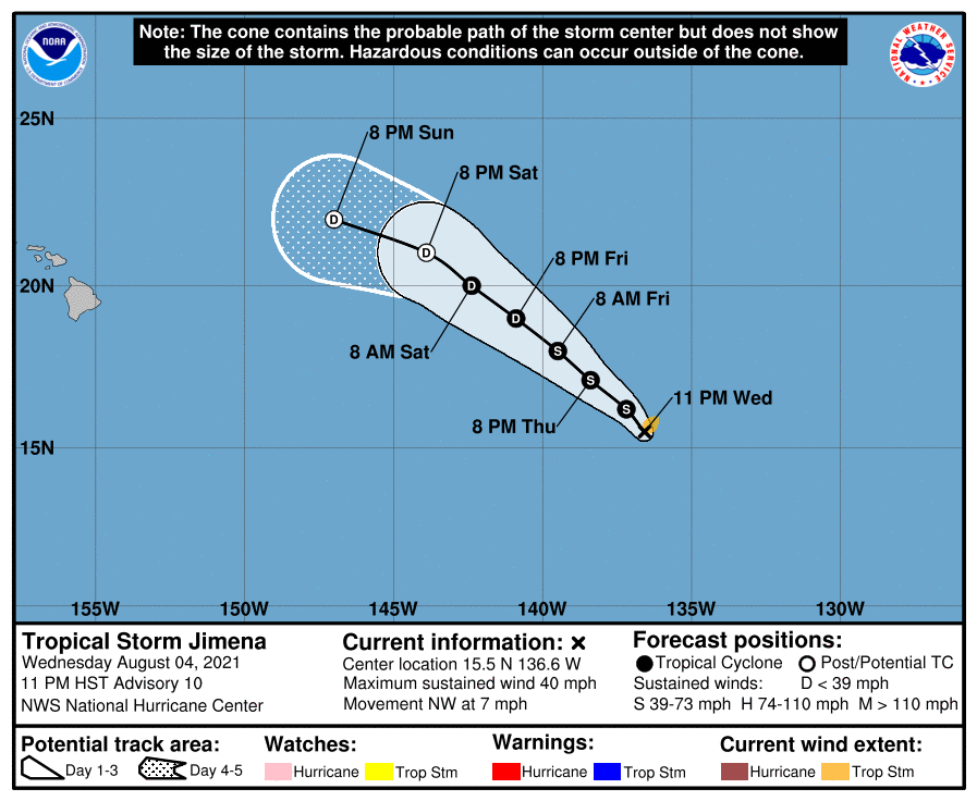
Tropical Storm Jimena Discussion Number  10
NWS National Hurricane Center Miami FL       EP092021
1100 PM HST Wed Aug 04 2021

Deep convection has increased near the center of the cyclone during
the last several hours, and an outer convective band is present in
the southeastern semicircle.  Subjective satellite intensity
estimates are 35 kt from TAFB and SAB, and the CIMSS satellite
consensus estimate is 39 kt.  Based on these data, the system is
upgraded to Tropical Storm Jimena with 35-kt winds.

The initial motion is 315/6 kt.  A mid-level ridge to the northeast
of the tropical cyclone is forecast to continue for the next 2-3
days, and this should keep Jimena moving generally northwestward.  
After that time, a west-northwestward motion is expected as the
weakening system is steered more by the low-level flow.  The track
guidance models have shifted a bit to the right since the previous
advisory. Therefore, the official forecast will also be nudged to
the right.  However, the new forecast track still lies to the left
of the consensus models.

While Jimena is in a moist and low-shear environment, the storm is
moving over decreasing sea surface temperatures, with the center
forecast to be over 25 C water in about 24 h.  Thus, little
additional strengthening is expected.  After 24 h, the system
should weaken due to even colder SSTs and increasing shear.  The
new intensity forecast has only minor tweaks from the previous
forecast, and it lies near the upper edge of the intensity guidance.


FORECAST POSITIONS AND MAX WINDS

INIT  05/0900Z 15.5N 136.6W   35 KT  40 MPH
12H  05/1800Z 16.2N 137.2W   35 KT  40 MPH
24H  06/0600Z 17.1N 138.4W   35 KT  40 MPH
36H  06/1800Z 18.0N 139.5W   35 KT  40 MPH
48H  07/0600Z 19.0N 140.9W   30 KT  35 MPH
60H  07/1800Z 20.0N 142.4W   30 KT  35 MPH
72H  08/0600Z 21.0N 143.9W   25 KT  30 MPH...POST-TROP/REMNT LOW
96H  09/0600Z 22.0N 147.0W   20 KT  25 MPH...POST-TROP/REMNT LOW
120H  10/0600Z...DISSIPATED

$$
Forecaster Beven
005543gspn84yf4mm08paf.png
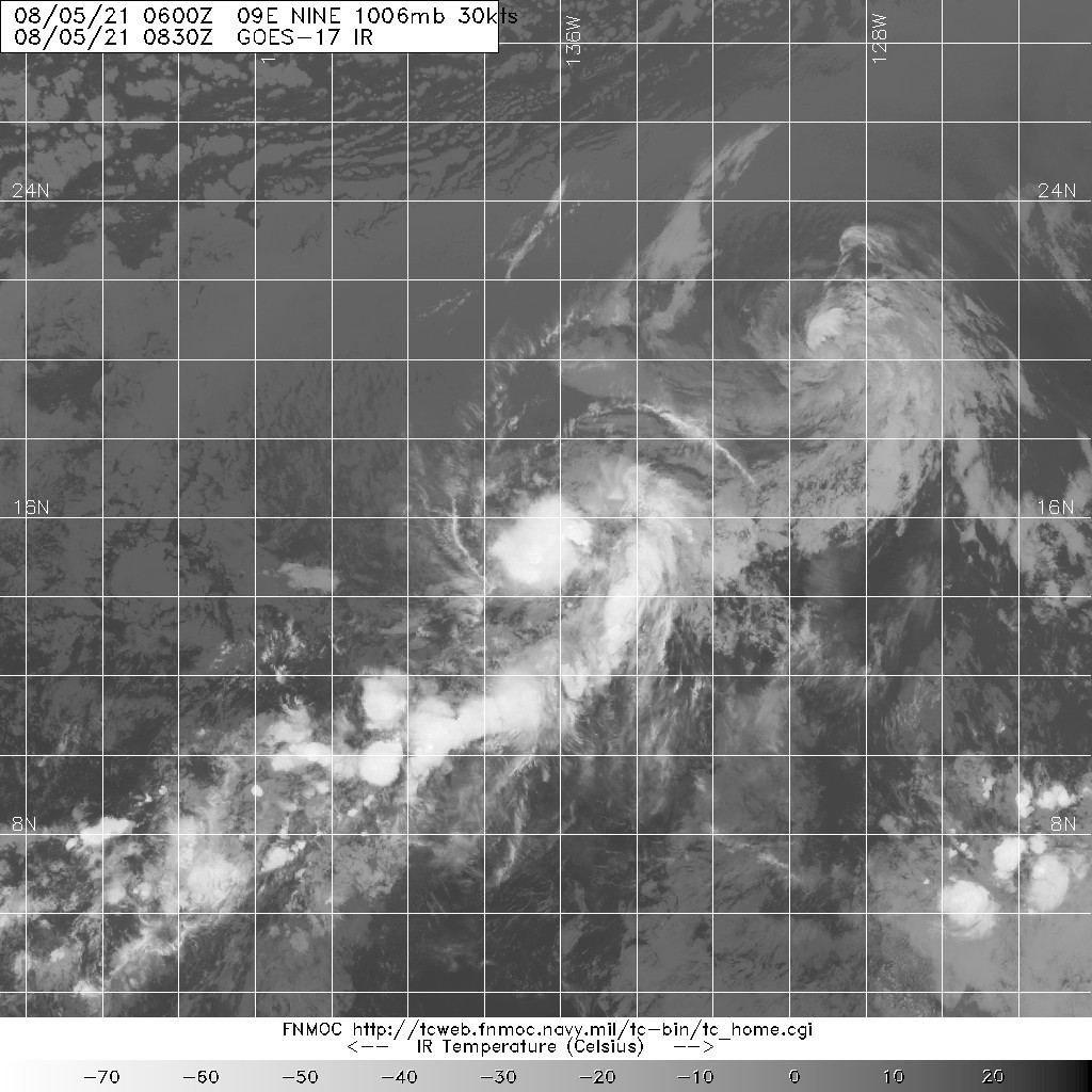
20210805.0830.goes-17.ir.09E.NINE.30kts.1006mb.15.3N.136.4W.100pc.jpg
回復

使用道具 舉報

快速回覆
您需要登錄後才可以回帖 登錄 | 立即加入

本版積分規則

本平台僅供學術討論之用,預報應以氣象局為準

威普網站虛擬主機贊助公司

臺灣第一個天氣類型社群平台 即時天氣資訊、精準颱風動態

線上客服
FB傳送訊息
廣告行銷
精準行銷 物超所值
官方粉專
發佈 快速回復 返回頂部 返回列表