開啟輔助訪問
 找回密碼
 立即加入

10E.Ignacio 短暫成旋

簽到天數: 1650 天

[LV.Master]伴壇終老

2021-7-31 14:00 | 顯示全部樓層
  熱帶風暴  
編號:10 E
名稱:Ignacio
20210803.0200.goes-17.ir.10E.IGNACIO.35kts.1005mb.19.3N.115.4W.100pc.jpg
  基本資料  
擾動編號日期:2021 07 31 13
命名日期  :2021 08 02 23
撤編日期  :2021 08 05 14
登陸地點  :

  巔峰時期資料  
近中心最強風速 :35  kt ( TS )
海平面最低氣壓 :1005 百帕

  擾動編號資料  
91E.INVEST.15kts.1007mb.10N.102W

20210731.0500.goes-17.ir.91E.INVEST.15kts.1007mb.10N.102W.100pc.jpg
NHC:50%
1. Recent satellite-derived wind data indicate that a broad area of
low pressure has formed a few hundred miles south-southwest of the
coast of southern Mexico.  Conditions appear conducive for
continued development of this system, and a tropical depression is
likely to form early next week while it moves west-northwestward at
10 to 15 mph, away from the coast of Mexico.
* Formation chance through 48 hours...medium...50 percent.
* Formation chance through 5 days...high...70 percent.

two_pac_2d1 (26).png two_pac_5d1 (25).png
以上資料來自:NHC、颱風論壇整理製作

評分

參與人數 1水氣能量 +15 +1 收起 理由
t02436 + 15 + 1

查看全部評分

回復

使用道具 舉報

簽到天數: 1650 天

[LV.Master]伴壇終老

老農民版夜神月|2021-8-1 00:12 | 顯示全部樓層
JTWC發布TCFA 214822tj4m4p72pk794prp.gif 233134jkkk6iuuj22228r7.jpeg

WTPN21 PHNC 311330
MSGID/GENADMIN/JOINT TYPHOON WRNCEN PEARL HARBOR HI//
SUBJ/TROPICAL CYCLONE FORMATION ALERT (INVEST 91E)//
RMKS/
1. FORMATION OF A SIGNIFICANT TROPICAL CYCLONE IS POSSIBLE WITHIN
150 NM EITHER SIDE OF A LINE FROM 11.8N 104.8W TO 15.2N 110.9W
WITHIN THE NEXT 12 TO 24 HOURS. AVAILABLE DATA DOES NOT JUSTIFY
ISSUANCE OF NUMBERED TROPICAL CYCLONE WARNINGS AT THIS TIME.
WINDS IN THE AREA ARE ESTIMATED TO BE 18 TO 23 KNOTS. METSAT
IMAGERY AT 311200Z INDICATES THAT A CIRCULATION CENTER IS LOCATED
NEAR 11.9N 105.2W. THE SYSTEM IS MOVING WEST-NORTHWESTWARD AT 10
KNOTS.
2. REMARKS: AN AREA OF CONVECTION (INVEST 91E) HAS PERSISTED NEAR
11.9N 105.2W, APPROXIMATELY 1415 NM SOUTH-SOUTHEAST OF SAN DIEGO,
CALIFORNIA. ANIMATED ENHANCED INFRARED SATELLITE IMAGERY AND A
311200Z SSMIS 91GHZ MICROWAVE IMAGE DEPICT DEEPENED CONVECTION
WRAPPING INTO A CONSOLIDATING LOW LEVEL CIRCULATION (LLC). UPPER-
LEVEL ANALYSIS INDICATES THE DISTURBANCE IS LOCATED IN AN AREA OF
FAVORABLE CONDITIONS WITH WARM SEA SURFACE TEMPERATURES (27-28 C),
GOOD EQUATORWARD OUTFLOW, OFFSET BY LOW-MODERATE VERTICAL WIND SHEAR
(10-20 KTS). MAXIMUM SUSTAINED SURFACE WINDS ARE ESTIMATED AT 18 TO
23 KNOTS. MINIMUM SEA LEVEL PRESSURE IS ESTIMATED TO BE NEAR 1005
MB. THE POTENTIAL FOR THE DEVELOPMENT OF A SIGNIFICANT TROPICAL
CYCLONE WITHIN THE NEXT 24 HOURS IS HIGH.
3. THIS ALERT WILL BE REISSUED, UPGRADED TO WARNING OR CANCELLED BY
011330Z.
//
NNNN
20210731.1350.f17.91pct91h91v.91E.INVEST.20kts.1010mb.11.9N.105.2W.090pc.jpg 20210731.120000.ASCAT.mta.r76695.wrave2.91E.INVEST.gif
回復

使用道具 舉報

簽到天數: 1650 天

[LV.Master]伴壇終老

老農民版夜神月|2021-8-1 07:52 | 顯示全部樓層
NHC展望提升至80%,High
1. Showers and thunderstorms associated with a broad area of low
pressure located about 400 miles southwest of the coast of southern
Mexico are becoming better organized.  Continued gradual
development of this system is expected, and a tropical depression
is likely to form during the next day or two before environmental
conditions become less conducive for development.  This disturbance
is expected to move west-northwestward at 10 to 15 mph, away from
the coast of Mexico.
* Formation chance through 48 hours...high...80 percent.
* Formation chance through 5 days...high...80 percent.
two_pac_2d1 (27).png two_pac_5d1 (26).png
91E_gefs_latest (1).png
回復

使用道具 舉報

簽到天數: 1650 天

[LV.Master]伴壇終老

老農民版夜神月|2021-8-2 05:05 | 顯示全部樓層
NHC升格10E 203743_5day_cone_with_line_and_wind.png 20210801.2000.goes-16.vis.2km.10E.TEN.30kts.1007mb.17.1N.111.4W.pc.jpg
20210801.1734.mtb.ASCAT.wind.91E.INVEST.30kts-1007mb.171N.1114W.25km.noqc.jpeg

000
WTPZ45 KNHC 012037
TCDEP5

Tropical Depression Ten-E Discussion Number   1
NWS National Hurricane Center Miami FL       EP102021
300 PM MDT Sun Aug 01 2021

The well-defined low pressure system located well offshore the
southwestern coast of Mexico that the National Hurricane Center has
been monitoring the past few days has developed enough organized
deep convection to be designated as a tropical depression. Although
the convection is strongly sheared and displaced to the west of the
slightly elongated low-level center, barely meeting the criteria for
a tropical cyclone, a recent 1733Z ASCAT-B scatterometer pass
revealed a few 28-kt surface wind vectors in the northeastern
quadrant. Thus, the initial intensity is set at what could be a
generous 30 kt. Socorro Island reported a wind gust to 34 kt in a
passing narrow band of showers around 1630 UTC.

The initial motion estimate is west-northwestward or 300/12 kt.
Embedded within deep-layer east-southeasterly steering flow between
Hurricane Hilda to the west-southwest and a sprawling subtropical
ridge to the north, the cyclone is forecast to continue moving
west-northwestward throughout the relatively short forecast period.
The NHC forecast track lies down the middle of the tightly packed
simple- and corrected-consensus models.

The depression has a very narrow window of opportunity of about 24 h
to strengthen. Moderate-to-strong northeasterly vertical wind shear
that has been hindering development the past few days is expected to
gradually decrease from the current 19-22 kt down to around 10-12 kt
in 18-24 h, which could allow for some slight intensification late
tonight and/or early Monday morning when another nocturnal burst of
convection is likely to occur. By 36 h, however, the cyclone is
forecast to move over sub-26C sea-surface temperatures and into a
drier and more stable air mass, which could induce rapid weakening,
with the system degenerating into a remnant low by 48 h and
dissipation expected by 72 h. The official intensity forecast is
similar to but slightly above the simple- and corrected-consensus
intensity models IVCN and HCCA, respectively.


FORECAST POSITIONS AND MAX WINDS

INIT  01/2100Z 17.4N 111.9W   30 KT  35 MPH
12H  02/0600Z 18.1N 113.5W   30 KT  35 MPH
24H  02/1800Z 19.0N 115.7W   35 KT  40 MPH
36H  03/0600Z 19.9N 117.5W   30 KT  35 MPH
48H  03/1800Z 20.6N 119.3W   25 KT  30 MPH...POST-TROP/REMNT LOW
60H  04/0600Z 20.9N 120.9W   20 KT  25 MPH...POST-TROP/REMNT LOW
72H  04/1800Z...DISSIPATED

$$
Forecaster Stewart
10E_gefs_latest.png
回復

使用道具 舉報

簽到天數: 3279 天

[LV.Master]伴壇終老

t02436|2021-8-2 23:54 | 顯示全部樓層
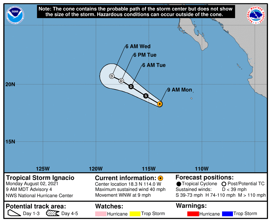
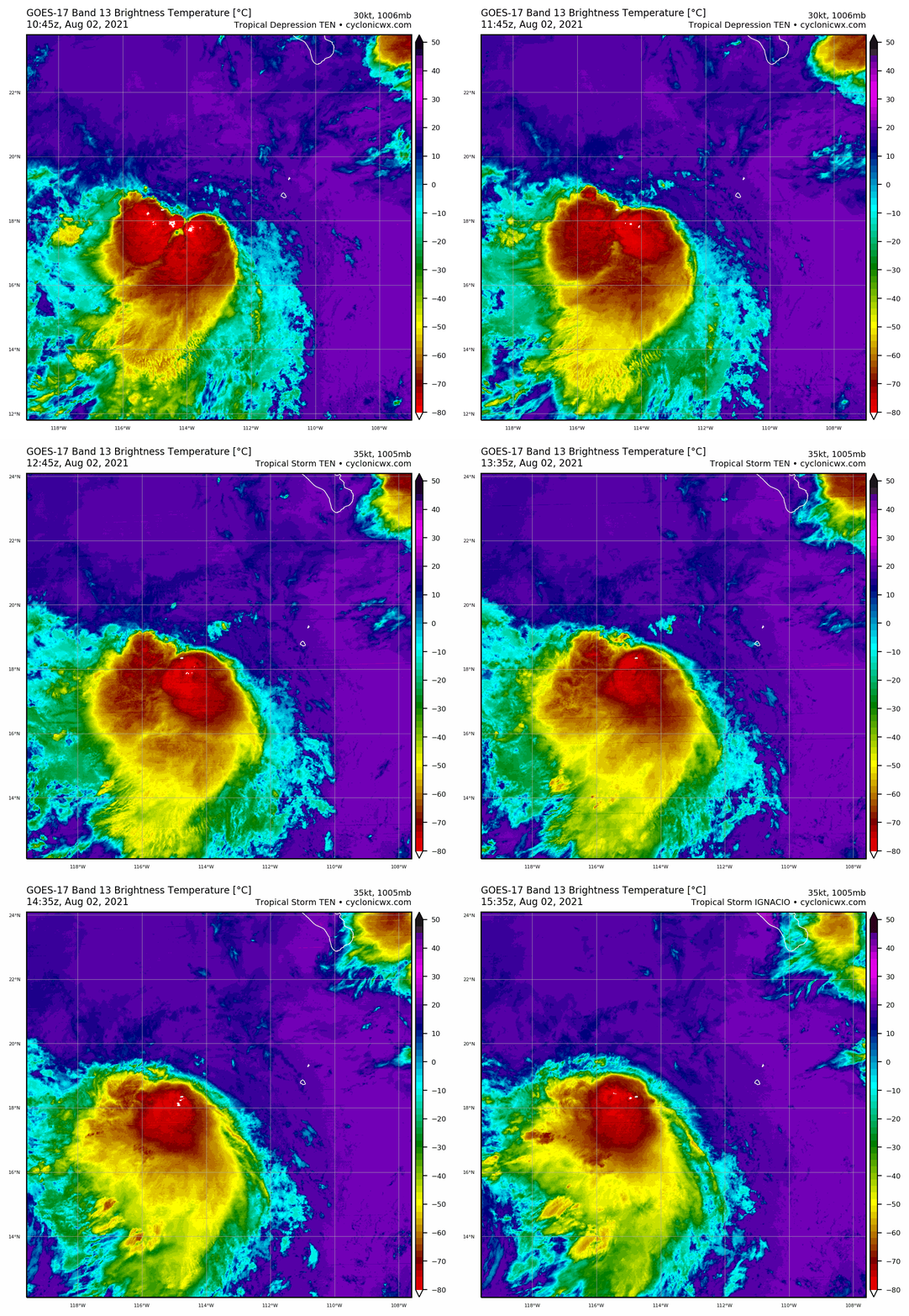
15Z命名Ignacio
000
WTPZ45 KNHC 021433
TCDEP5

Tropical Storm Ignacio Discussion Number   4
NWS National Hurricane Center Miami FL       EP102021
900 AM MDT Mon Aug 02 2021

A large burst of deep convection has developed near the center and
over most of the southwestern semicircle of the cyclone. Recent
subjective satellite intensity estimates are a consensus T2.5/35 kt
from TAFB and SAB, and objective estimates from UW-CIMSS ADT and
SATCON are 37 kt and 39 kt, respectively. Based on these data, the
intensity has been increased to 35 kt, making the system the ninth
tropical storm of the 2021 eastern North Pacific hurricane season.

Tropical Storm Ignacio has continued to move west-northwestward, and
the initial motion estimate is 295/08 kt. Both the track forecast
and synoptic reasoning remain unchanged for this advisory. Ignacio
is expected to maintain a west-northwestward motion, wedged between
a strong mid-/upper-level ridge to the north and Hurricane Hilda to
the southwest throughout the 48-hour forecast period. The new track
forecast is essentially just an update of the previous advisory
track, and lies down the middle of the tightly packed consensus
track models.

Ignacio is likely near its peak intensity given that northeasterly
vertical wind shear of 18-20 kt is expected to keep the strongest
convection displaced away from the strongest surface winds that are
likely occurring in the northeastern semicircle. By 24 hours or so,
Ignacio will be moving over sub-26C sea-surface temperatures and
into even stronger wind shear, which should induce steady weakening,
with dissipation expected by 60 hours. The new NHC intensity
forecast is similar to the previous advisory, and closely follows a
blend of the NOAA-HCCA and IVCN consensus intensity models.


FORECAST POSITIONS AND MAX WINDS

INIT  02/1500Z 18.3N 114.0W   35 KT  40 MPH
12H  03/0000Z 19.0N 115.3W   35 KT  40 MPH
24H  03/1200Z 19.8N 116.7W   30 KT  35 MPH
36H  04/0000Z 20.3N 117.6W   25 KT  30 MPH...POST-TROP/REMNT LOW
48H  04/1200Z 20.7N 118.5W   20 KT  25 MPH...POST-TROP/REMNT LOW
60H  05/0000Z...DISSIPATED

$$
Forecaster Stewart
143414_5day_cone_with_line.png

goes17_rainbow_10E.gif
回復

使用道具 舉報

簽到天數: 1650 天

[LV.Master]伴壇終老

老農民版夜神月|2021-8-4 06:05 | 顯示全部樓層
NHC認為即將成為殘餘低氣壓
000
WTPZ45 KNHC 032036
TCDEP5

Tropical Depression Ignacio Discussion Number   9
NWS National Hurricane Center Miami FL       EP102021
200 PM PDT Tue Aug 03 2021

Ignacio has been devoid of deep convection within 75 nmi of the
center for the more than 6 hours now due to strong easterly vertical
wind shear. The initial intensity has been lowered to 25 kt based on
the continued degradation in the convective pattern and a 1536Z
ASCAT-A scatterometer pass that revealed a patch of 27-kt surface
wind vectors south of the center. The small cyclone is expected to
meander over water temperatures near 26 deg C for the next 12-24
hours, while the shear is forecast to increase to near 30 kt during
that time. Owing to these unfavorable environmental conditions,
Ignacio is forecast to degenerate into a remnant low pressure system
by late this afternoon, followed by dissipation on Wednesday.

The initial motion estimate is now 090/03 kt. Ignacio is forecast to
make a small clockwise loop within weak low-level steering flow
until the system dissipates around 36 hours. The new NHC official
track forecast is similar to the previous advisory track, and lies
close to the tightly clustered simple- and corrected-consensus
models.


FORECAST POSITIONS AND MAX WINDS

INIT  03/2100Z 20.4N 115.7W   25 KT  30 MPH
12H  04/0600Z 20.4N 115.3W   25 KT  30 MPH...POST-TROP/REMNT LOW
24H  04/1800Z 19.9N 114.5W   20 KT  25 MPH...POST-TROP/REMNT LOW
36H  05/0600Z...DISSIPATED

$$
Forecaster Stewart
203751_5day_cone_no_line_and_wind.png 20210803.2130.goes-16.vis.2km.10E.IGNACIO.25kts.1009mb.20.4N.115.8W.pc.jpg
LATEST (30).jpg
回復

使用道具 舉報

簽到天數: 1650 天

[LV.Master]伴壇終老

老農民版夜神月|2021-8-4 10:57 | 顯示全部樓層
NHC停編 023724_5day_cone_no_line_and_wind.png

439
WTPZ45 KNHC 040236
TCDEP5

Post-Tropical Cyclone Ignacio Discussion Number  10
NWS National Hurricane Center Miami FL       EP102021
800 PM PDT Tue Aug 03 2021

Ignacio consists of a swirl of low-level clouds and has been devoid
of deep convection anywhere near its center since this morning.  
Therefore the system no longer qualifies as a tropical cyclone and
is now a remnant low, or a post-tropical cyclone.

The low has been moving east-southeastward, or about 120/6 kt.  A
turn toward the southeast and south is expected on Wednesday while
the system moves around the northern side of a low-level ridge.

Although the low will be moving over slightly warmer waters, strong
easterly shear should prevent regeneration, and the system should
dissipate in 24 h or so.

This is the last advisory issued by the National Hurricane Center
on Ignacio.  For additional information on the remnant low please
see High Seas Forecasts issued by the National Weather Service,
under AWIPS header NFDHSFEPI, WMO header FZPN02 KWBC, and on the web
at ocean.weather.gov/shtml/NFDHSFEPI.php


FORECAST POSITIONS AND MAX WINDS

INIT  04/0300Z 20.1N 115.0W   25 KT  30 MPH...POST-TROPICAL
12H  04/1200Z 19.6N 114.6W   20 KT  25 MPH...POST-TROP/REMNT LOW
24H  05/0000Z...DISSIPATED

$$
Forecaster Pasch
20210804.0120.goes-17.vis.2km.10E.IGNACIO.25kts.1009mb.20.2N.115.2W.pc.jpg
回復

使用道具 舉報

快速回覆
您需要登錄後才可以回帖 登錄 | 立即加入

本版積分規則

本平台僅供學術討論之用,預報應以氣象局為準

威普網站虛擬主機贊助公司

臺灣第一個天氣類型社群平台 即時天氣資訊、精準颱風動態

線上客服
FB傳送訊息
廣告行銷
精準行銷 物超所值
官方粉專
發佈 快速回復 返回頂部 返回列表