開啟輔助訪問
 找回密碼
 立即加入

13E.Marty 原07L出海重編 短暫發展

簽到天數: 1650 天

[LV.Master]伴壇終老

2021-8-22 14:15 | 顯示全部樓層
  熱帶風暴  
編號:13 E
名稱:Marty
025251giiyovnqi3qnpmmp.jpg
  基本資料  
擾動編號日期:2021 08 22 14
命名日期  :2021 08 23 14
撤編日期  :2021 08 27 02
登陸地點  :


  巔峰時期資料  
近中心最強風速 :40  kt (
TS )
海平面最低氣壓 :1000 百帕

  擾動編號資料  

94E.INVEST.15kts.1005mb.19N.109W.
20210822.0540.goes-16.ir.94E.INVEST.15kts.1005mb.19N.109W.100pc.jpg
NHC:80%
1. A large area of disorganized showers and thunderstorms along and
offshore of the coast of west-central Mexico is associated with
the remnants of Grace.  Environmental conditions are forecast to be
conducive for development, and a tropical depression is likely to
form within the next day or so while the system moves westward at
10 to 15 mph away from the coast of Mexico.
* Formation chance through 48 hours...high...80 percent.
* Formation chance through 5 days...high...80 percent.

two_pac_2d1 (37).png two_pac_5d1 (37).png
以上資料來自:NHC、颱風論壇整理製作

評分

參與人數 1水氣能量 +15 +1 收起 理由
周子堯@FB + 15 + 1 熱帶擾動首帖

查看全部評分

回復

使用道具 舉報

簽到天數: 1650 天

[LV.Master]伴壇終老

老農民版夜神月|2021-8-23 04:29 | 顯示全部樓層
NHC展望提升至90%
1. Showers and thunderstorms associated with an area of low pressure
located about 100 miles west of the coast of west-central Mexico are
becoming better organized.  Environmental conditions are expected to
be conducive for further development, and a tropical depression is
likely to form later today or on Monday while the system moves
westward at 10 to 15 mph, away from the coast of Mexico.
* Formation chance through 48 hours...high...90 percent.
* Formation chance through 5 days...high...90 percent.
two_pac_2d1 (38).png two_pac_5d1 (38).png
94E_gefs_latest.png 20210822.1543.mta.ASCAT.wind.94E.INVEST.30kts-1004mb.193N.1076W.25km.noqc.jpeg
回復

使用道具 舉報

簽到天數: 1650 天

[LV.Master]伴壇終老

老農民版夜神月|2021-8-23 09:40 | 顯示全部樓層
JTWC續發TCFA
WTPN21 PHNC 230100
MSGID/GENADMIN/JOINT TYPHOON WRNCEN PEARL HARBOR HI//
SUBJ/TROPICAL CYCLONE FORMATION ALERT (INVEST 94E) REISSUED//
RMKS/
1. FORMATION OF A SIGNIFICANT TROPICAL CYCLONE IS POSSIBLE WITHIN
120 NM EITHER SIDE OF A LINE FROM 19.2N 106.9W TO 20.5N 114.5W
WITHIN THE NEXT 12 TO 24 HOURS. AVAILABLE DATA DOES NOT JUSTIFY
ISSUANCE OF NUMBERED TROPICAL CYCLONE WARNINGS AT THIS TIME.
WINDS IN THE AREA ARE ESTIMATED TO BE 25 TO 30 KNOTS. METSAT
IMAGERY AT 221800Z INDICATES THAT A CIRCULATION CENTER IS LOCATED
NEAR 19.3N 107.6W. THE SYSTEM IS MOVING WESTWARD AT 17 KNOTS.
2. REMARKS: THE AREA OF CONVECTION (INVEST 94E, PREVIOUSLY REMNANTS
OF HURRICANE 07L) PREVIOUSLY LOCATED NEAR 19.7N 99.5W IS NOW LOCATED
NEAR 19.3N 107.6W, APPROXIMATELY 194 NM EAST OF SOCORRO ISLAND.
ANIMATED MULTISPECTRAL SATELLITE IMAGERY (MSI) DEPICTS A PARTIALLY
OBSCURED LOW-LEVEL CIRCULATION CENTER (LLCC) WITH CONVECTION
CONSOLIDATING OVER THE CENTER. INVEST 94E IS IN A FAVORABLE
ENVIRONMENT FOR DEVELOPMENT CHARACTERIZED BY WARM (29-30C) SEA
SURFACE TEMPERATURES (SST), POLEWARD OUTFLOW ALOFT, AND LOW (<15 KT)
VERTICAL WIND SHEAR (VWS). GLOBAL MODELS INDICATE A SHORT TERM
CONSOLIDATION AS IT PROPAGATES WEST-NORTHWESTWARD. MAXIMUM SUSTAINED
SURFACE WINDS ARE ESTIMATED AT 25 TO 30 KNOTS. MINIMUM SEA LEVEL
PRESSURE IS ESTIMATED TO BE NEAR 1000 MB. THE POTENTIAL FOR THE
DEVELOPMENT OF A SIGNIFICANT TROPICAL CYCLONE WITHIN THE NEXT 24
HOURS IS HIGH.
3. THIS ALERT WILL BE REISSUED, UPGRADED TO WARNING OR CANCELLED BY
240100Z.//
NNNN
ep9421.gif 94E_230100sair.jpg
回復

使用道具 舉報

簽到天數: 1650 天

[LV.Master]伴壇終老

老農民版夜神月|2021-8-23 15:50 | 顯示全部樓層
本帖最後由 老農民版夜神月 於 2021-8-23 15:53 編輯

NHC直接升格TS,命名Marty
13E MARTY 210823 0600 19.9N 110.3W EPAC 35 1000
20210823.0720.goes-16.ir.13E.MARTY.35kts.1000mb.19.9N.110.3W.100pc.jpg LATEST (36).jpg
回復

使用道具 舉報

簽到天數: 1650 天

[LV.Master]伴壇終老

老農民版夜神月|2021-8-24 05:22 | 顯示全部樓層
本帖最後由 老農民版夜神月 於 2021-8-24 05:24 編輯

對流開始減弱,NHC認為目前便是13E的巔峰 20210823.1522.mta.ASCAT.wind.13E.MARTY.40kts-1001mb.208N.1134W.25km.noqc.jpeg
FORECAST POSITIONS AND MAX WINDS

INIT  23/2100Z 20.9N 114.1W   40 KT  45 MPH
12H  24/0600Z 21.0N 116.2W   40 KT  45 MPH
24H  24/1800Z 21.0N 118.6W   35 KT  40 MPH
36H  25/0600Z 21.0N 120.6W   30 KT  35 MPH
48H  25/1800Z 20.9N 122.6W   30 KT  35 MPH...POST-TROP/REMNT LOW
60H  26/0600Z 20.9N 124.8W   25 KT  30 MPH...POST-TROP/REMNT LOW
72H  26/1800Z 20.8N 127.0W   20 KT  25 MPH...POST-TROP/REMNT LOW
96H  27/1800Z 19.4N 131.9W   20 KT  25 MPH...POST-TROP/REMNT LOW
120H  28/1800Z...DISSIPATED

204319_5day_cone_no_line_and_wind.png 13E_BAND01.gif
13E_RBTOP.gif 13E_CA.gif
回復

使用道具 舉報

簽到天數: 1650 天

[LV.Master]伴壇終老

老農民版夜神月|2021-8-25 02:54 | 顯示全部樓層
NHC降格TD
000
WTPZ43 KNHC 241433
TCDEP3

Tropical Depression Marty Discussion Number   6
NWS National Hurricane Center Miami FL       EP132021
800 AM PDT Tue Aug 24 2021

There has been no significant deep convection within 100 nmi of
Marty's center since about 0600 UTC. The cyclone's cloud pattern now
consists of some mid-level clouds and mostly low-level cold-air
stratocumulus clouds. The current intensity of 30 kt is based on a
unanimous Dvorak satellite classification of T1.5/2.5 (25 kt/35 kt)
from TAFB and SAB, which has resulted in Marty being downgraded to
a tropical depression. Due to the cyclone's future track remaining
over sub-26C sea-surface temperatures, coupled with additional
entrainment of stable low clouds, Marty is now forecast to
degenerate to a post-tropical remnant low later today. The new
NHC intensity forecast closely follows the trends of the intensity
consensus models IVCN and NOAA-HCCA.

The initial motion remains westward, or 270/10 kt. The strong
deep-layer ridge to the north of the weakening shallow cyclone is
expected to keep Marty on a generally westward track over the next
36 hours or so, followed by a west-southwestward motion thereafter
until the cyclone dissipates.  The new official forecast track lies
near the extreme southern edge of the model guidance envelope, owing
to the models' slight poleward bias noted over the past 36 hours.


FORECAST POSITIONS AND MAX WINDS

INIT  24/1500Z 20.6N 118.1W   30 KT  35 MPH
12H  25/0000Z 20.6N 119.9W   25 KT  30 MPH...POST-TROP/REMNT LOW
24H  25/1200Z 20.6N 121.9W   25 KT  30 MPH...POST-TROP/REMNT LOW
36H  26/0000Z 20.6N 124.0W   20 KT  25 MPH...POST-TROP/REMNT LOW
48H  26/1200Z 20.5N 126.1W   20 KT  25 MPH...POST-TROP/REMNT LOW
60H  27/0000Z 20.2N 128.4W   20 KT  25 MPH...POST-TROP/REMNT LOW
72H  27/1200Z 19.6N 130.9W   20 KT  25 MPH...POST-TROP/REMNT LOW
96H  28/1200Z...POST-TROP/REMNT LOW

$$
Forecaster Stewart
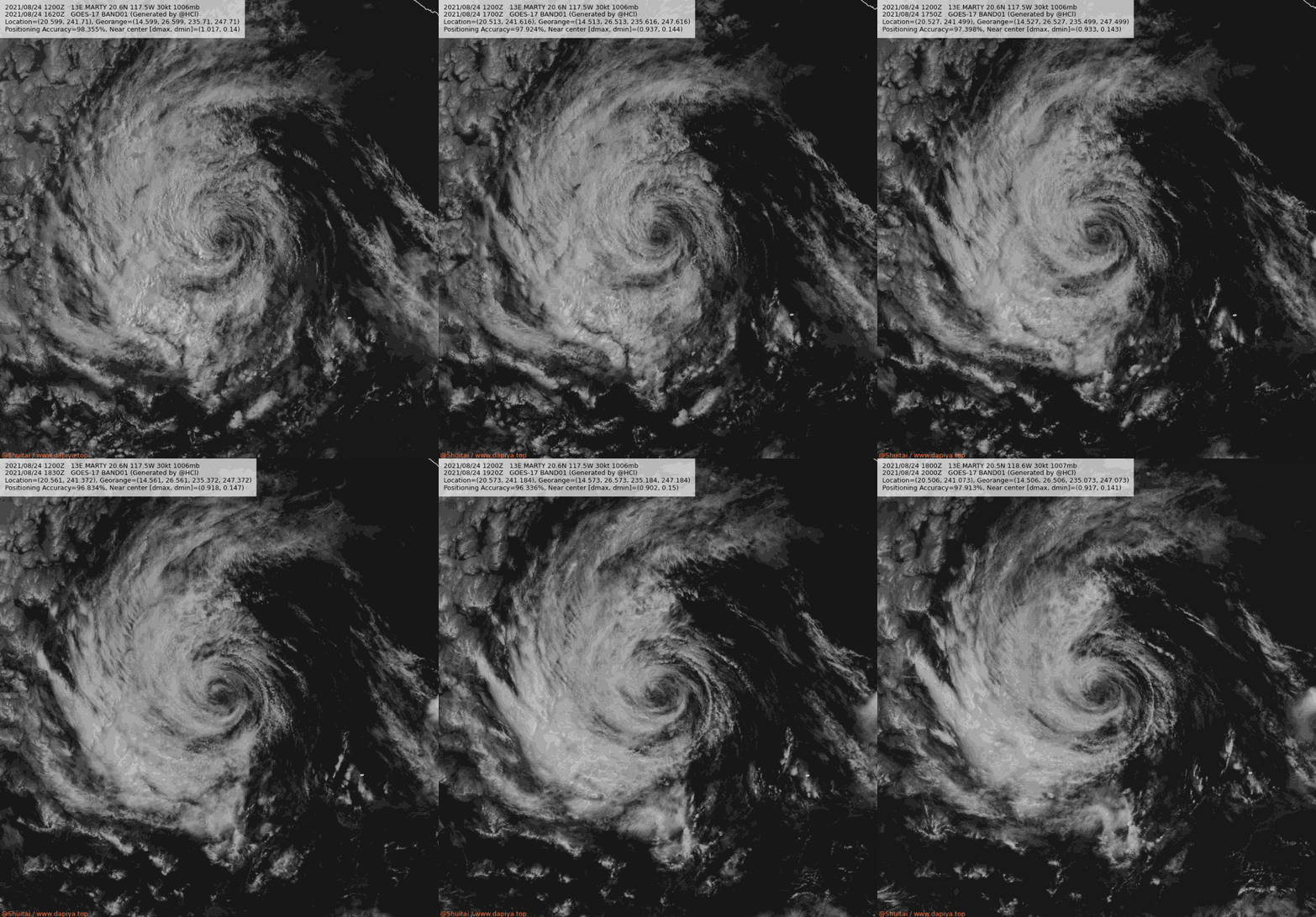
143401_5day_cone_no_line_and_wind.png 20210824.1820.goes-17.vis.2km.13E.MARTY.30kts.1006mb.20.6N.117.5W.pc.jpg
13E_241200sair.jpg
回復

使用道具 舉報

簽到天數: 1650 天

[LV.Master]伴壇終老

老農民版夜神月|2021-8-25 04:49 | 顯示全部樓層
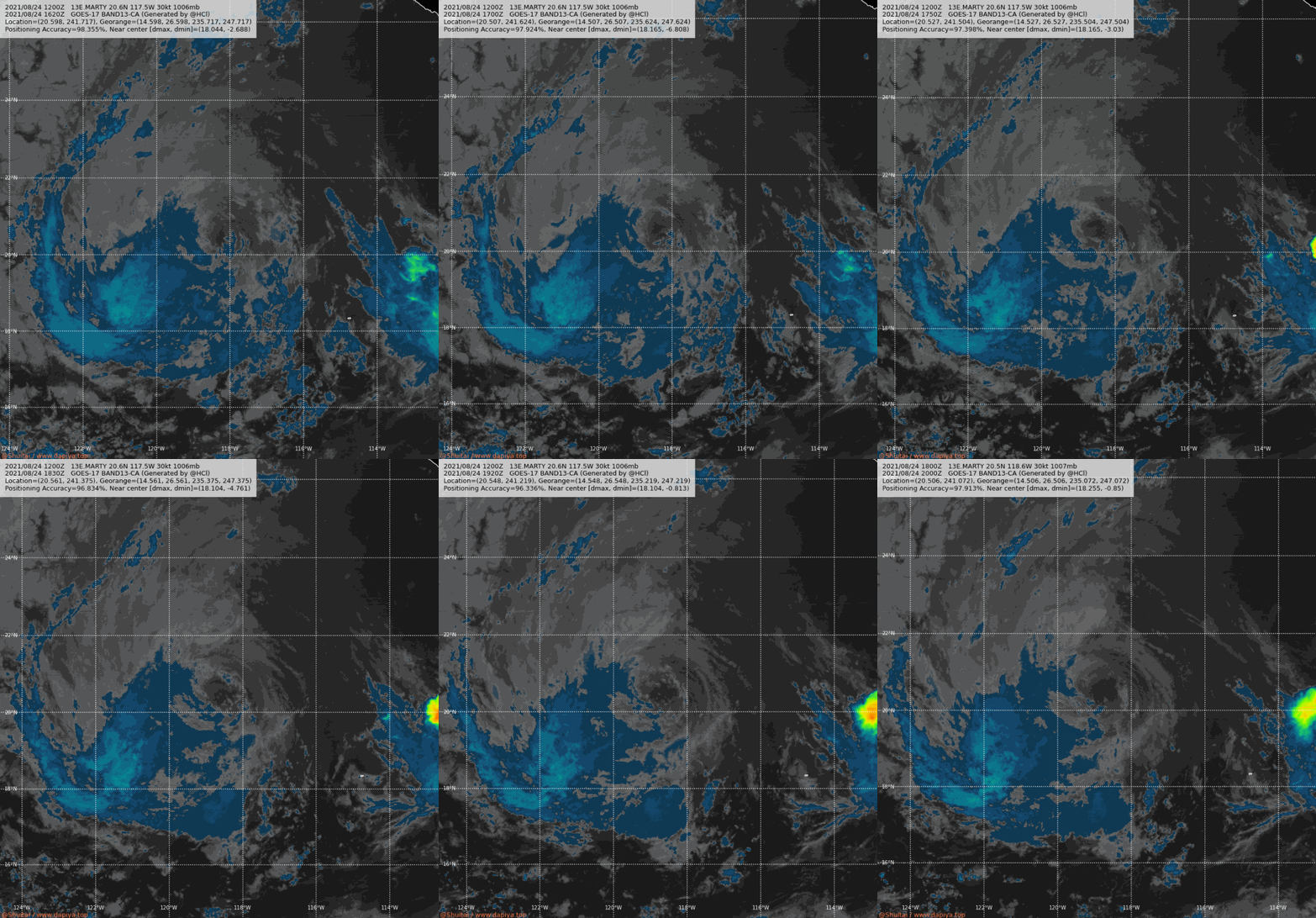
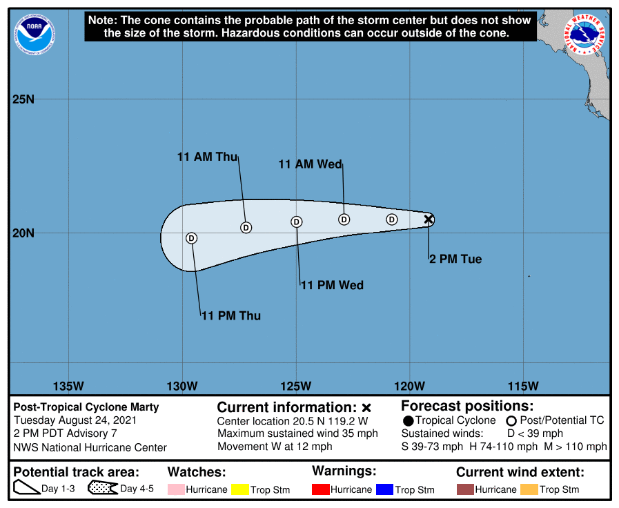
NHC判定已成為後熱帶氣旋 LATEST (44).jpg 13E_BAND01 (1).gif
13E_CA (1).gif 204455_5day_cone_no_line_and_wind.png

738
WTPZ43 KNHC 242041
TCDEP3

Post-Tropical Cyclone Marty Discussion Number   7
NWS National Hurricane Center Miami FL       EP132021
200 PM PDT Tue Aug 24 2021

There has been no significant deep convection within 100 nmi of
Marty's center for more than 12 hours. As a result, Marty has
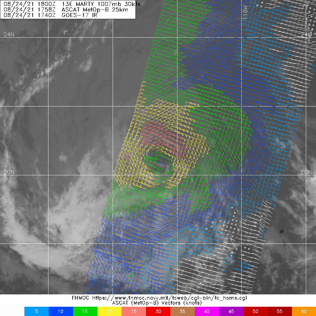
degenerated into a remnant low. The initial intensity has been
maintained at 30 kt based on ASCAT-B/-A passes between 1700-1800
UTC that still showed a significant fetch of 25-kt winds over much
of the northern quadrant, including a few embedded 28-kt vectors.
Since Marty is forecast to remain over sub-26C sea-surface
temperatures and within a large field of cold-air stratocumulus
clouds, gradual spin down of the vortex and weakening of the
cyclone's peak winds are expected until dissipation occurs in about
72 hours. The new NHC intensity forecast is similar to the previous
advisory, and closely follows a blend of the IVCN and NOAA-HCCA
intensity consensus models.

The initial motion estimate remains westward, or 270/10 kt.  For
the next 36 hours or so, the remnant low is forecast to move
westward along the southern periphery of a sprawling deep-layer
ridge located northwest through northeast of Marty. Thereafter, a
motion toward the west-southwest is expected until the cyclone
dissipates. The new NHC forecast track is essentially just an
extension of the previous advisory track, and lies down the middle
of the tightly packed consensus models, which have shifted a little
to the south on this forecast cycle.

This is the last advisory being issued on Marty.  For additional
information on the remnant low, please see High Seas Forecasts
issued by the National Weather Service under AWIPS header NFDHSFEPI
and WMO header FZPN02 KWBC.


FORECAST POSITIONS AND MAX WINDS

INIT  24/2100Z 20.5N 119.2W   30 KT  35 MPH...POST-TROP/REMNT LOW
12H  25/0600Z 20.5N 120.8W   25 KT  30 MPH...POST-TROP/REMNT LOW
24H  25/1800Z 20.5N 122.9W   25 KT  30 MPH...POST-TROP/REMNT LOW
36H  26/0600Z 20.4N 125.0W   20 KT  25 MPH...POST-TROP/REMNT LOW
48H  26/1800Z 20.2N 127.2W   20 KT  25 MPH...POST-TROP/REMNT LOW
60H  27/0600Z 19.8N 129.6W   20 KT  25 MPH...POST-TROP/REMNT LOW
72H  27/1800Z...DISSIPATED

$$
Forecaster Stewart
回復

使用道具 舉報

快速回覆
您需要登錄後才可以回帖 登錄 | 立即加入

本版積分規則

本平台僅供學術討論之用,預報應以氣象局為準

威普網站虛擬主機贊助公司

臺灣第一個天氣類型社群平台 即時天氣資訊、精準颱風動態

線上客服
FB傳送訊息
廣告行銷
精準行銷 物超所值
官方粉專
發佈 快速回復 返回頂部 返回列表