簽到天數: 2141 天 [LV.Master]伴壇終老
|
 周子堯@FB|2022-4-25 17:23
|
顯示全部樓層
周子堯@FB|2022-4-25 17:23
|
顯示全部樓層
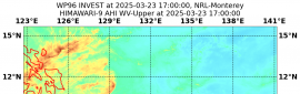
螺旋性、風場等狀況都還不錯,JTWC發布TCFA;BOM開始發報,惟不看好成旋
IDW24000
Australian Bureau of Meteorology
Tropical Cyclone Warning Centre
TROPICAL CYCLONE INFORMATION BULLETIN
Issued at 2:23 pm WST on Monday 25 April 2022
A Tropical Low was located at 2:00 pm AWST (12:30 pm CCT) near 14.8S 100.9E,
that is 530 km east southeast of Cocos Island and moving south at 11 kilometres
per hour.
Tropical Low 34U is expected to turn north-northwest within the next 12 to 24
hours and begin weakening. It is not forecast to develop into a tropical
cyclone, but there is a moderate chance that it will do so tonight or on
Tuesday, and this may persist into Wednesday.
Tropical Low 34U poses no threat to the Australian mainland. It may pass near
or to the north of the Cocos (Keeling) Islands on Thursday or Friday, and
produce a period of strong winds and heavy rainfall over the islands.
The next Information Bulletin will be issued at 9 pm AWST (7:30 pm CCT).
IDW27600
TROPICAL CYCLONE TECHNICAL BULLETIN: AUSTRALIA - WESTERN REGION
Issued by AUSTRALIAN BUREAU OF METEOROLOGY TROPICAL CYCLONE WARNING CENTRE
at: 0709 UTC 25/04/2022
Name: Tropical Low
Identifier: 34U
Data At: 0600 UTC
Latitude: 14.8S
Longitude: 100.9E
Location Accuracy: within 20nm (35 km)
Movement Towards: south (180 deg)
Speed of Movement: 6 knots (11 km/h)
Maximum 10-Minute Wind: 40 knots (75 km/h)
Maximum 3-Second Wind Gust: 55 knots (100 km/h)
Central Pressure: 996 hPa
Radius of 34-knot winds NE quadrant: 120 nm (220 km)
Radius of 34-knot winds SE quadrant:
Radius of 34-knot winds SW quadrant:
Radius of 34-knot winds NW quadrant:
Radius of 48-knot winds NE quadrant:
Radius of 48-knot winds SE quadrant:
Radius of 48-knot winds SW quadrant:
Radius of 48-knot winds NW quadrant:
Radius of 64-knot winds: nm ( km)
Radius of Maximum Winds: nm ( km)
Dvorak Intensity Code: T2.5/2.5/D1.0/24HRS STT:D0.5/06HRS
Pressure of outermost isobar: 1008 hPa
Radius of outermost closed isobar: 180 nm (335 km)
FORECAST DATA
Date/Time : Location : Loc. Accuracy: Max Wind : Central Pressure
(UTC) : degrees : nm (km): knots(km/h): hPa
+06: 25/1200: 14.6S 100.8E: 045 (080): 040 (075): 996
+12: 25/1800: 14.2S 100.8E: 060 (115): 040 (075): 997
+18: 26/0000: 13.9S 100.7E: 075 (140): 040 (075): 997
+24: 26/0600: 13.4S 100.6E: 090 (165): 035 (065): 1000
+36: 26/1800: 12.5S 100.1E: 100 (180): 030 (055): 1003
+48: 27/0600: 12.0S 99.5E: 125 (235): 030 (055): 1002
+60: 27/1800: 11.5S 98.9E: 140 (260): 030 (055): 1002
+72: 28/0600: 10.9S 98.4E: 165 (305): 030 (055): 1002
+96: 29/0600: 10.2S 97.3E: 195 (365): 030 (055): 1002
+120: 30/0600: 9.7S 96.6E: 225 (415): 030 (055): 1002
REMARKS:
Tropical low 34U has improved in structure during the past 24 hours, with
convection consolidating around the low level circulation centre and displaying
improved curvature and banding.
Dvorak analysis is based on a curved band pattern with average 3 hour curvature
of 0.45 to 0.5. This could arguably be higher on the most recent imagery,
though a gap has developed between the large convective swathe to the northeast
and the smaller area to the SW (the latter likely associated with the LLCC). DT
is 2.5. MET is also 2.5 based on a 24 hour D trend with no PAT adjustment.
Final T and CI 2.5. An ASCAT pass at 02Z depicted patchy gales in the NE
quadrant peaking at about 40 knots. These gales have likely migrated to the SE
quadrant given the convective evolution since then. No objective intensity
estimates are currently available. Intensity is analysed at 40 knots (10 minute
mean).
34U is currently located to the west of an upper anticyclone. CIMSS upper level
winds suggest that the system is being influenced by some northwesterly shear,
and this is reflected somewhat in the satellite signature. However, analysed
shear near the centre is low (10-15 knots). Upper poleward outflow from the
system is good. There is therefore a moderate chance that the system will
intensify further into a tropical cyclone tonight.
Beyond that, the atmospheric environment is expected to deteriorate as an
amplifying upper trough to the south will increase wind shear across the
system. Most guidance indicates that 34U will begin to shear and weaken during
Tuesday in response. The remnant shallow system will be steered to the north
and then northwest by a low level southeasterly surge through the remainder of
the week.
Copyright Commonwealth of Australia
==
The next bulletin for this system will be issued by: 25/1330 UTC.

2. REMARKS: THE AREA OF CONVECTION (INVEST 98S) PREVIOUSLY LOCATED
NEAR 13.6S 99.9E IS NOW LOCATED NEAR 14.2S 101.0E, APPROXIMATELY 268
NM EAST-SOUTHEAST OF COCOS ISLAND. ENHANCED MULTISPECTRAL SATELLITE
IMAGERY DEPICTS DEEP CONVECTION OVERHEAD A PARTIALLY EXPOSED LOW
LEVEL CIRCULATION (LLC). RECENT SCATTEROMETRY DATA INDICATES WINDS
OF UP TO 30 KNOTS IN THE EASTERN SEMICIRCLE OF THE LLC.
ENVIRONMENTAL ANALYSIS REVEALS FAVORABLE CONDITIONS FOR DEVELOPMENT
DEFINED BY; ROBUST POLEWARD OUTFLOW ALOFT, LOW (10-15KT) VERTICAL
WIND SHEAR, AND WARM (28-29C) SEA SURFACE TEMPERATURES. GLOBAL
MODELS ARE IN GOOD AGREEMENT THAT INVEST 98S WILL HAVE LITTLE
DEVELOPMENT AS IT REMAINS QUASI-STATIONARY OVER THE NEXT 24-36 HOURS
AND THEN HAVING A SLIGHT NORTHWARD TRACK THERE AFTER. MAXIMUM
SUSTAINED SURFACE WINDS ARE ESTIMATED AT 25 TO 30 KNOTS. MINIMUM SEA
LEVEL PRESSURE IS ESTIMATED TO BE NEAR 1000 MB. THE POTENTIAL FOR
THE DEVELOPMENT OF A SIGNIFICANT TROPICAL CYCLONE WITHIN THE NEXT 24
HOURS REMAINS HIGH. THIS SUPERSEDES REF A.


|
|


 提升卡
提升卡 千斤頂
千斤頂.jpg")