簽到天數: 3291 天 [LV.Master]伴壇終老
|
 t02436|2022-6-14 23:15
|
顯示全部樓層
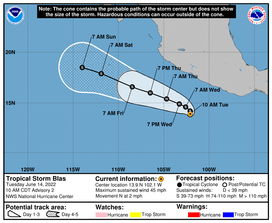
命名Blas,上望70節。
000
WTPZ42 KNHC 141458
TCDEP2
Tropical Storm Blas Discussion Number 2
NWS National Hurricane Center Miami FL EP022022
1000 AM CDT Tue Jun 14 2022
Satellite images indicate that the tropical cyclone southwest of
Mexico continues to become better organized, with plenty of banding
in the eastern semicircle and increased central deep convection.
Dvorak estmates have increased to 35-45 kt, and the initial wind
speed is raised to 40 kt, making this system the second tropical
storm of the season.
The environment near Blas looks conducive for further
intensification during the next couple of days, with very warm
waters and generally light shear. However, increased northeasterly
shear is likely to begin on Thursday due to a building upper-level
anticyclone over Mexico. Model guidance is higher than the last
cycle, mostly due to the initial wind speed, and the NHC intensity
forecast matches that trend. Weakening should commence by the end
of the week due to stronger shear and cooler waters.
Blas is drifting northward, caught in an area of light steering
beneath a distant mid-tropospheric low over northern Mexico. The
tropical cyclone should move little today and then start moving to
the west-northwest at a faster pace due to the low moving out and a
ridge building over Mexico. This motion should take the system
gradually away from southwestern Mexico later in the week. Similar
to the last cycle, although there is some spread in the models,
especially in terms of forward speed, they generally agree on the
overall scenario. This track forecast lies near the various
consensus aids, a bit north of the last NHC track forecast.
Even though the system is forecast to remain well off the coast of
Mexico, the associated swells are expected to affect portions of
the coast of southwestern Mexico in a day or so.
FORECAST POSITIONS AND MAX WINDS
INIT 14/1500Z 13.9N 102.1W 40 KT 45 MPH
12H 15/0000Z 14.2N 102.1W 50 KT 60 MPH
24H 15/1200Z 14.6N 102.6W 60 KT 70 MPH
36H 16/0000Z 14.9N 103.3W 70 KT 80 MPH
48H 16/1200Z 15.4N 104.7W 70 KT 80 MPH
60H 17/0000Z 16.0N 106.5W 65 KT 75 MPH
72H 17/1200Z 16.6N 108.5W 60 KT 70 MPH
96H 18/1200Z 17.9N 111.9W 50 KT 60 MPH
120H 19/1200Z 18.5N 114.0W 40 KT 45 MPH
$$
Forecaster Blake/Bucci

|
|