簽到天數: 3291 天 [LV.Master]伴壇終老
|
 t02436|2022-7-11 00:02
|
顯示全部樓層
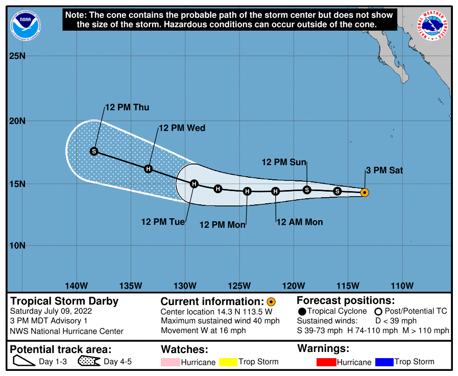
9日21Z報已編號05E並直接命名Darby
ZCZC MIATCDEP5 ALL
TTAA00 KNHC DDHHMM
Tropical Storm Darby Discussion Number 1
NWS National Hurricane Center Miami FL EP052022
300 PM MDT Sat Jul 09 2022
The area of low pressure we have been monitoring well offshore the
southwestern coast of Mexico has become much better organized on
conventional satellite imagery throughout the day. The current
structure on visible satellite imagery consists of a well-defined
curved band to the north and west with what already appears to be a
small central dense overcast forming near the estimated center. In
fact, there is already a small dimple beginning to appear on the
last few frames of visible satellite imagery which could be the
initial indications that a small inner core is forming. While C-band
scatterometer imagery (ASCAT-B/C) largely missed the small storm
earlier today, there was a KU-band scatterometer late this morning
that had enough non-rain contaminated vectors to indicate the system
likely possesses a closed circulation. The subjective Dvorak
classifications at 1800 UTC from TAFB/SAB were both T2.0/30 kt, but
given the continued improvement on satellite imagery since then,
advisories are being initiated on Tropical Storm Darby at this time,
with winds of 35 kt.
The current motion of Darby is just north of due west at 280/14 kt.
A general due westward motion is expected over the next 24-48 h as
the small storm is situated on the south side of a expansive
deep-layer subtropical ridge centered over the southwestern United
States. Towards the end of the forecast period, Darby will be
approaching a weakness in this ridge, which may allow the storm to
start gaining latitude after 48 hours. The initial track forecast of
Darby is very close to the reliable track consensus aids, though is
just a shade further north, in deference to both the GFS and ECMWF
forecasts.
The structure of Darby is quite impressive for a system that has
only recently formed. In addition, both the GFS- and ECMWF-based
SHIPS guidance indicate that the small storm will remain in a low
shear (under 10 kt), warm sea-surface temperatures (above 28C), and
sufficient mid-level moisture for the next 2-3 days. Assuming an
inner core forms relatively soon, this environment likely favors
quick intensification. In fact, the ECMWF SHIPS-RII guidance
indicates a 44 percent chance of a 25 kt or higher increase in
intensity over the next 24 hours. While the current NHC intensity
forecast will not go that high quite yet, it does make Darby a
hurricane in only 36 h. This intensity forecast is on the upper-end
of the guidance envelope, but not far off the HFIP corrected
consensus approach (HCCA) that is also near hurricane intensity in
36 h. Late in the forecast, Darby will likely encounter cooler ocean
waters and much higher shear, which should begin to induce weakening
by the end of the forecast period.
FORECAST POSITIONS AND MAX WINDS
INIT 09/2100Z 14.3N 113.5W 35 KT 40 MPH
12H 10/0600Z 14.4N 116.0W 45 KT 50 MPH
24H 10/1800Z 14.5N 118.8W 55 KT 65 MPH
36H 11/0600Z 14.4N 121.7W 65 KT 75 MPH
48H 11/1800Z 14.4N 124.3W 75 KT 85 MPH
60H 12/0600Z 14.6N 127.0W 80 KT 90 MPH
72H 12/1800Z 15.0N 129.2W 80 KT 90 MPH
96H 13/1800Z 16.2N 133.4W 65 KT 75 MPH
120H 14/1800Z 17.6N 138.4W 45 KT 50 MPH
$$
Forecaster Papin
NNNN 
|
|