開啟輔助訪問
 找回密碼
 立即加入

04L 登陸墨西哥 無緣命名

簽到天數: 601 天

[LV.9]以壇為家II

2022-8-19 10:13 | 顯示全部樓層
本帖最後由 霧峰追風者 於 2022-8-22 04:07 編輯

基本資料  
編號    :99 L
擾動編號日期:2022 08 19 02
撤編日期  :2022 00 00 00
99L.INVEST.20kts-1010mb-17.7N-90.7W
AL, 99, 2022081818,   , BEST,   0, 177N,  907W,  20, 1010, DB,.jpeg
1. Southwestern Gulf of Mexico:
Showers and thunderstorms associated with a tropical wave located
over northern Guatemala and southeastern Mexico have become a little
better organized since yesterday. This system is forecast to emerge
into the Bay of Campeche tomorrow, where an area of low pressure
could form. After that, additional slow development of this system
is possible while it moves northwestward over the southwestern Gulf
of Mexico.  By Saturday night, the system is expected to move
inland over northeastern Mexico.  An Air Force Reserve Hurricane
Hunter aircraft is scheduled to investigate the system on Friday,
if necessary.
* Formation chance through 48 hours...low...30 percent.
* Formation chance through 5 days...low...30 percent.

two_atl_2d1.png

評分

參與人數 1水氣能量 +15 +1 收起 理由
周子堯@FB + 15 + 1 熱帶擾動首帖

查看全部評分

回復

使用道具 舉報

簽到天數: 601 天

[LV.9]以壇為家II

霧峰追風者|2022-8-19 10:14 | 顯示全部樓層
1. Southwestern Gulf of Mexico:
Scattered showers and thunderstorms are associated with a tropical
wave located over southeastern Mexico that is expected to emerge
into the Bay of Campeche tomorrow morning. Environmental conditions
appear favorable for additional development, and a tropical
depression could form while the system moves northwestward over the
southwestern Gulf of Mexico on Friday or Saturday. However, by
Saturday night, the system is expected to move inland over
northeastern Mexico, which will end its chances of development. An
Air Force Reserve Hurricane Hunter aircraft is scheduled to
investigate the system tomorrow, if necessary.
* Formation chance through 48 hours...medium...40 percent.
* Formation chance through 5 days...medium...40 percent.
two_atl_2d1 (1).png
回復

使用道具 舉報

簽到天數: 601 天

[LV.9]以壇為家II

霧峰追風者|2022-8-20 04:10 | 顯示全部樓層
1. Southwestern Gulf of Mexico:
Satellite imagery indicates that showers and thunderstorms
associated with the broad low pressure area over the southwestern
Gulf of Mexico and the Bay of Campeche continue to become better
organized.  Environmental conditions appear favorable for
additional development, and a tropical depression could form later
today, tonight, or on Saturday while the system moves northwestward
across the southwestern and western Gulf of Mexico.  However, by
Saturday night, the system is expected to move inland over
northeastern Mexico, which will end its chances of development. An
Air Force Reserve Hurricane Hunter aircraft is currently enroute to
investigate the system.  Interests along the northeastern coast of
Mexico and the lower Texas coast should monitor the progress of
this system.  Regardless of development, this system could bring
locally heavy rains to portions of northeastern Mexico and southern
Texas over the weekend.
* Formation chance through 48 hours...high...70 percent.
* Formation chance through 5 days...high...70 percent.
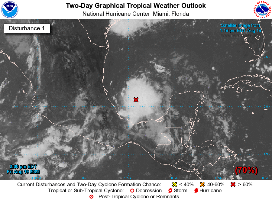
two_atl_2d1.png
回復

使用道具 舉報

簽到天數: 601 天

[LV.9]以壇為家II

霧峰追風者|2022-8-20 04:43 | 顯示全部樓層
升格04L
04L.INVEST.30kts.1009mb.20.4N.94W.
20220819.2000.goes-16.vis.2km.04L.INVEST.30kts.1009mb.20.4N.94W.pc.jpg
回復

使用道具 舉報

簽到天數: 601 天

[LV.9]以壇為家II

霧峰追風者|2022-8-22 04:05 | 顯示全部樓層
登陸墨西哥,無緣命名。
838
WTNT44 KNHC 210235
TCDAT4

Potential Tropical Cyclone Four Discussion Number   6
NWS National Hurricane Center Miami FL       AL042022
1000 PM CDT Sat Aug 20 2022

Satellite imagery, surface observations, and radar data indicate
that the main vorticity center of the disturbance has moved inland
over northeastern Mexico and the associated convection has
decreased.  Based on this, the chance for development has ended and
the coastal warnings are being discontinued.  Therefore, this will
be the last NHC advisory on this system.  Additional information on
this system can be found in statements from local Weather Forecast
Offices in the United States and from the Meteorological Service of
Mexico.

The disturbance should move north-northwestward for the next 12 h
or so before it becomes absorbed in a larger weather system
developing over Texas.


KEY MESSAGES:

1. Locally gusty winds may occur in squalls over portions of
northeastern Mexico and southern Texas tonight.

2. Rain from the disturbance should affect the northeastern coast
of Mexico across the state of Tamaulipas tonight and Sunday. This
rainfall could produce isolated flash flooding. The system could
also produce isolated moderate to heavy rainfall across portions of
South Texas, but significant flooding impacts are not expected
there.

FORECAST POSITIONS AND MAX WINDS

INIT  21/0300Z 25.3N  97.9W   30 KT  35 MPH...INLAND
12H  21/1200Z 26.7N  98.7W   20 KT  25 MPH...INLAND
24H  22/0000Z...DISSIPATED

$$
Forecaster Beven
104501f53gt2shd3t2vdw4.png 112511z0ii91q0ts4hsi91.gif 104505jzdjdq6jqzjat8dg.jpg
回復

使用道具 舉報

快速回覆
您需要登錄後才可以回帖 登錄 | 立即加入

本版積分規則

本平台僅供學術討論之用,預報應以氣象局為準

威普網站虛擬主機贊助公司

臺灣第一個天氣類型社群平台 即時天氣資訊、精準颱風動態

線上客服
FB傳送訊息
廣告行銷
精準行銷 物超所值
官方粉專
發佈 快速回復 返回頂部 返回列表