開啟輔助訪問
 找回密碼
 立即加入

15L.Lisa 加勒比海西行 趨向猶加敦半島

簽到天數: 2414 天

[LV.Master]伴壇終老

2022-10-31 22:49 | 顯示全部樓層
基本資料  
編號    :15 L
擾動編號日期:2022 10 28 02
撤編日期  :2022 00 00 00
95L.INVEST.20kts.1009mb.12N.66W

20221028.1220.goes-16.vis.2km.95L.INVEST.20kts.1009mb.12N.66W.pc.jpg
NHC:20%
1. Eastern Caribbean:
A broad area of low pressure over the southeastern Caribbean Sea
is producing a large area of disorganized showers and thunderstorms
extending from the Windward Islands west-northwestward for several
hundred miles.  Environmental conditions are forecast to be
conducive for gradual development over the next few days, and a
tropical depression is likely to form this weekend or early
next week while the disturbance moves slowly westward or
west-northwestward over the central Caribbean Sea.  Regardless of
development, locally heavy rainfall is possible over portions of
the Lesser Antilles, the Virgin Islands, and Puerto Rico through
this weekend.
* Formation chance through 48 hours...low...20 percent.
* Formation chance through 5 days...high...70 percent.

two_atl_2d1.png

評分

參與人數 1水氣能量 +15 +1 收起 理由
t02436 + 15 + 1

查看全部評分

回復

使用道具 舉報

簽到天數: 2414 天

[LV.Master]伴壇終老

0908morakot|2022-10-31 22:51 | 顯示全部樓層
053
WTNT45 KNHC 302058
TCDAT5

Potential Tropical Cyclone Fifteen Discussion Number   1
NWS National Hurricane Center Miami FL       AL152022
500 PM EDT Sun Oct 30 2022

This morning we were fortunate to have concurrent NOAA and Air Force
Reserve Hurricane Hunter missions, which provided a wealth of
flight-level, Tail Doppler Radar, and dropsonde data over the system
in the central Caribbean Sea. The data indicated that a
well-defined, while somewhat broad, circulation had formed with a
minimum pressure of 1005 mb. A combination of SFMR winds and surface
dropsonde data also suggested that the system had 35-kt winds in its
northern semicircle. With that said, the satellite presentation of
the system currently lacks sufficient convective organization to be
considered a tropical cyclone. However, given the well-defined
center and tropical-storm-force winds, there is significant risk for
tropical storm conditions in the near future in portions of Jamaica
and Grand Cayman Island. With the expectation that this system will
likely become a tropical storm soon, advisories have been initiated
on Potential Tropical Cyclone Fifteen.

The estimated motion of the disturbance is off to the west-northwest
at 290/9 kt. This general motion is forecast to continue for the
next day or so, as an expansive mid-level ridge is currently
centered north of the system and expected to move westward with
the cyclone. Toward the end of the forecast period, the ridge may
nose further westward as a deep-layer trough becomes established
well to the the northeast, which could result in a south of due
west motion when the system approaches the coast of
Belize.  Landfall is expected between the 72- and 96-hour forecast
points. The initial NHC track forecast is roughly a blend of the
latest GFS and ECMWF guidance, which is also quite close to  
the HCCA and TCVA consensus aids.

Based on the current structure, it may take a bit longer for the
convection to become sufficently organized to allow the formation of
a tropical cyclone, but this is forecast to occur at some point
tonight, likely during the typical diurnal maximum. After deep
convection become better established, environmental conditions
appear to be conducive for further intensification, especially in
the 24-48 hour period when the vertical wind shear is expected to be
lowest (5-15 kt) as the system traverses 29-30 C sea-surface
temperatures. Mid-level relative humidity is quite low (55-60
percent), but given the relatively low shear, this may act to keep
the system's structure small with a constricted radius of maximum
winds. The initial intensity forecast after 24 hours closely follows
the latest HCCA and ICON intensity guidance, making the system a
Category 1 hurricane in 60-72 hours. The system should weaken
quickly over land and is forecast to dissipate before day 5.

Based on the latest forecast, the government of Jamaica has issued
a Tropical Storm Watch for Jamaica, and the government in the
Cayman Islands has issued a Tropical Storm Watch for Grand Cayman
Island.


Key Messages:

1. Tropical storm conditions are possible within the Tropical Storm
Watch areas beginning Monday for Jamaica and on Tuesday for Grand
Cayman Island.

2. Interests along the coast of Central America, especially near
Belize, should monitor the progress of this system. Additional
watches and warnings will likely be required early this week.


FORECAST POSITIONS AND MAX WINDS

INIT  30/2100Z 15.7N  73.6W   35 KT  40 MPH...POTENTIAL TROP CYCLONE
12H  31/0600Z 16.0N  74.9W   35 KT  40 MPH...TROPICAL CYCLONE
24H  31/1800Z 16.3N  76.6W   40 KT  45 MPH
36H  01/0600Z 16.7N  78.8W   50 KT  60 MPH
48H  01/1800Z 17.2N  81.3W   60 KT  70 MPH
60H  02/0600Z 17.5N  83.6W   65 KT  75 MPH
72H  02/1800Z 17.4N  85.7W   70 KT  80 MPH
96H  03/1800Z 16.4N  89.5W   35 KT  40 MPH...INLAND
120H  04/1800Z...DISSIPATED

$$
Forecaster Papin/Cangialosi
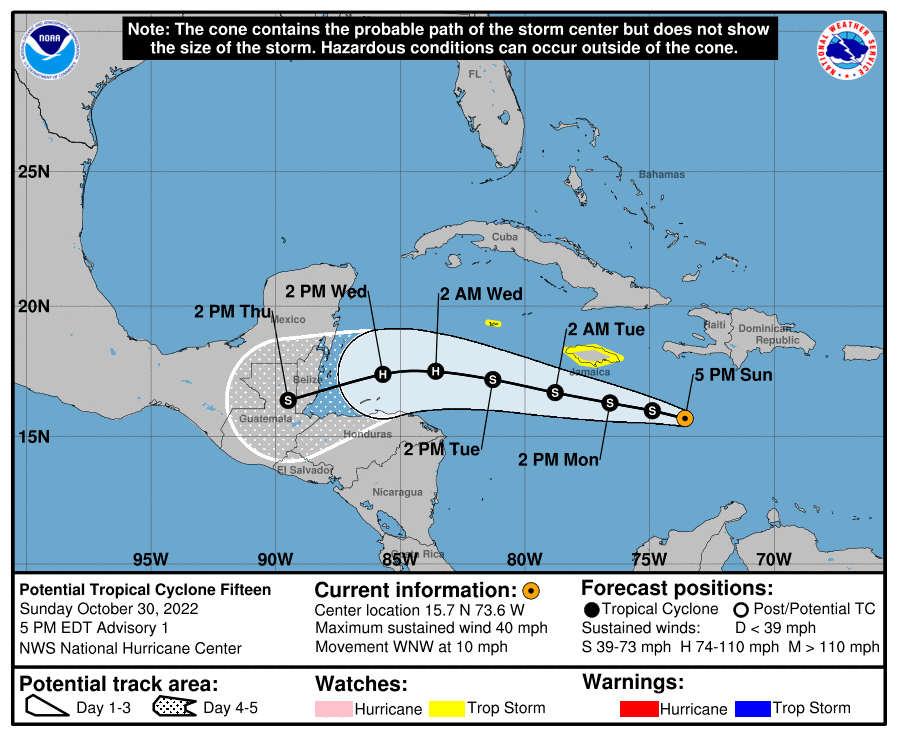
15L.png
回復

使用道具 舉報

簽到天數: 3291 天

[LV.Master]伴壇終老

t02436|2022-10-31 22:57 | 顯示全部樓層
15Z命名Lisa
145415_5day_cone_with_line.png
538
WTNT45 KNHC 311453
TCDAT5

Tropical Storm Lisa Discussion Number   4
NWS National Hurricane Center Miami FL       AL152022
1100 AM EDT Mon Oct 31 2022

GOES-16 1-minute visible imagery indicates that the low-level
circulation of the system has closed off again, although the system
is still a bit elongated north-to-south.  Westerly shear has caused
the center to be exposed to the west and north of the primary
convective banding features.  NOAA Hurricane Hunter tail Doppler
radar data also show that the low is tilted southeastward with
height, a reflection of the current shear.  Still, the plane had
numerous SFMR values of around 35 kt, and dropsonde data showed the
pressure has dropped to 1003 mb.  These values are sufficient to
call the system a tropical storm with an initial wind speed of 35
kt.

After a dip southward overnight, Lisa is moving westward again at
about 12 kt.  The storm should move westward to west-northwestward
for the next day or two under a mid-level ridge to the north.  As
the ridge intensifies in a few days, Lisa is likely to move
westward, or possibly a little south-of-west, while it approaches
Belize.  Model guidance remains in very good agreement, and
only a small southward adjustment was made to the previous forecast.

Lisa should encounter more conducive atmospheric and oceanic
conditions for the next few days, with increasing mid-level
humidities and generally lower shear.  The storm will likely still
have some bouts with drier air infiltrating in the northwestern
quadrant of the circulation, but the diminishing shear should lessen
the impact of this factor.  Thus slow intensification is shown for
the next few days, consistent with the interpolated previous
forecast.  It should be noted that the new NHC forecast is on the
high side of the guidance for this cycle, with a notable decrease of
the forecast intensity in many of the models.  The official
forecast is lower than the previous one, owing to the model trend,
but it is preferable to wait another cycle to make any larger
changes after the model suite ingests the plentiful aircraft data
for the 12 UTC suite.


Key Messages:

1. Tropical storm conditions are possible on Jamaica today.

2. Interests along the coast of Central America, especially near
Belize and the Yucatan Peninsula of Mexico, should monitor the
progress of this system. Additional watches and warnings will
likely be required by late today.


FORECAST POSITIONS AND MAX WINDS

INIT  31/1500Z 15.5N  77.3W   35 KT  40 MPH
12H  01/0000Z 15.8N  79.0W   40 KT  45 MPH
24H  01/1200Z 16.3N  81.4W   45 KT  50 MPH
36H  02/0000Z 16.8N  83.9W   50 KT  60 MPH
48H  02/1200Z 17.1N  86.3W   55 KT  65 MPH
60H  03/0000Z 17.1N  88.2W   65 KT  75 MPH
72H  03/1200Z 16.7N  90.0W   40 KT  45 MPH...INLAND
96H  04/1200Z...DISSIPATED

$$
Forecaster Blake

GOES14402022304ZJr4t6.jpg
回復

使用道具 舉報

快速回覆
您需要登錄後才可以回帖 登錄 | 立即加入

本版積分規則

0908morakot

    主題

    帖子

    69萬

    積分

    12級[颶風Hurricane]

    Rank: 12Rank: 12Rank: 12

12級[颶風Hurricane]

發訊息

本平台僅供學術討論之用,預報應以氣象局為準

威普網站虛擬主機贊助公司

臺灣第一個天氣類型社群平台 即時天氣資訊、精準颱風動態

線上客服
FB傳送訊息
廣告行銷
精準行銷 物超所值
官方粉專
發佈 快速回復 返回頂部 返回列表