開啟輔助訪問
 找回密碼
 立即加入

27P.Narelle 巔峰曾達澳式C5 登陸澳洲

簽到天數: 3419 天

[LV.Master]伴壇終老

king111807|2026-3-20 04:12 | 顯示全部樓層
BoM上看澳式C5

IDQ20018
TROPICAL CYCLONE TECHNICAL BULLETIN: AUSTRALIA - EASTERN REGION
Issued by AUSTRALIAN BUREAU OF METEOROLOGY TROPICAL CYCLONE WARNING CENTRE
at: 0106 UTC 18/03/2026
Name: Tropical Cyclone Narelle
Identifier: 34U
Data At: 0000 UTC
Latitude: 12.1S
Longitude: 153.5E
Location Accuracy: within 25nm (45 km)
Movement Towards: west (280 deg)
Speed of Movement: 9 knots (17 km/h)
Maximum 10-Minute Wind: 60 knots (110 km/h)
Maximum 3-Second Wind Gust: 85 knots (155 km/h)
Central Pressure: 984 hPa
Radius of 34-knot winds NE quadrant: 100 nm (185 km)
Radius of 34-knot winds SE quadrant: 90 nm (165 km)
Radius of 34-knot winds SW quadrant: 60 nm (110 km)
Radius of 34-knot winds NW quadrant: 50 nm (95 km)
Radius of 48-knot winds NE quadrant: 25 nm (45 km)
Radius of 48-knot winds SE quadrant: 30 nm (55 km)
Radius of 48-knot winds SW quadrant: 30 nm (55 km)
Radius of 48-knot winds NW quadrant: 25 nm (45 km)
Radius of 64-knot winds:   nm (  km)
Radius of Maximum Winds: 15 nm (30 km)
Dvorak Intensity Code: T4.0/4.0/D2.0/24HRS STT:0.5/6HRS
Pressure of outermost isobar: 1007 hPa
Radius of outermost closed isobar: 210 nm (390 km)
FORECAST DATA
Date/Time    : Location    : Loc. Accuracy: Max Wind   : Central Pressure
(UTC)        : degrees     :      nm  (km): knots(km/h): hPa
+06:  18/0600: 12.6S 152.0E:     035 (070):  070  (130):  978
+12:  18/1200: 13.0S 150.8E:     045 (085):  075  (140):  973
+18:  18/1800: 13.4S 149.5E:     055 (100):  090  (165):  960
+24:  19/0000: 13.7S 148.2E:     055 (105):  090  (165):  960
+36:  19/1200: 13.8S 145.9E:     060 (115):  105  (195):  944
+48:  20/0000: 13.9S 143.8E:     070 (130):  105  (195):  944
+60:  20/1200: 13.9S 141.6E:     080 (145):  045  (085):  994
+72:  21/0000: 14.0S 139.1E:     090 (165):  060  (110):  985
+96:  22/0000: 14.0S 134.2E:     100 (185):  040  (075):  998
+120: 23/0000: 14.2S 129.7E:     120 (220):  030  (055): 1003
REMARKS:
Tropical Cyclone Narelle (34U) continues to develop in the northern Coral Sea.
However, intensification has stalled somewhat in recent hours, possibly due to
Narelle's proximity to southeastern PNG islands. Position is based on visible
satellite imagery and recent ASCAT (2218 UTC) passes with good confidence.
SSMIS microwave imagery at 1742Z shows a microwave eye. No eye is visible on
visible or EIR imagery.

Dvorak analysis using a curved band pattern with a 3-hour averaged wrap of
0.9-1.2 yields a DT of 3.5-4.0, although the banding pattern in unclear. A CDO
of 90-100 with BF yields DF 4.0. A 24-hour D+ trend yields a MET of 3.5, and PT
adjusted to 4.0. FT/CI is based on PT and is 4.0. Intensity is estimated at 60
knots based on Dvorak and generally in line with objective aids. Objective
guidance at 2300 UTC unless otherwise stated (all one-minute mean); ADT 59 kn,
AidT 65 kn, DPRINT 64 kn, SATCON 64 kn (1600 UTC).  

Environmental conditions are favourable for further intensification. Narelle
lies in a region of low vertical wind shear, in the range of 5 to 10 knots, and
is expected to remain in this region with favourable low shear and good upper
outflow. Other parameters remain supportive at least until landfall, including,
warm sea surface temperatures of around 28  30  C, and generally deep moisture,
dry air is currently remaining well to the west and is unlikely to impact
development.  

Steady to rapid intensification is forecast until landfall.  The rate of
intensification may be aided from Thursday by the approach of a new upper
trough which leads to an increase in upper divergence and poleward outflow. A
category 5 peak intensity is forecast. This is expected to occur shortly before
interactions with the Queensland east coast increase, and consequently some
weakening before the centre of Narelle is anticipated. If Narelle tracks a
little further north it may maintain category 5 intensity until landfall.  

There is very good confidence in the westward tracks of Narelle, with the
subtropical ridge to the south the dominating steering mechanism. There
remains, however, some variation in how quickly Narelle moves west, and Narelle
may approach the north east Queensland coast as early as Thursday afternoon,
which is earlier than the current most likely forecast track. This uncertainty
in timing also impacts the intensification forecast, and there is a chance that
Narelle either begins to interact with land and weaken earlier, or slows and
intensifies more than forecast.

After crossing the east Queensland Coast Narelle is expected to continue to be
steered to the west by the subtropical ridge, moving back over waters of the
Gulf of Carpentaria, most likely overnight Friday or during Saturday. As
Narelle moves across the Cape York Peninsula it is likely to considerably
weaken, though is expected to remain a tropical cyclone. Once over Gulf waters,
the environment continues to be favourable and re-intensification is forecast.
There is forecast to be enough time over the warm waters of the Gulf (SSTs are
around 30  C), with light wind shear continuing, and sufficient deep moisture
for Narelle to intensify to a severe tropical cyclone again before crossing the
eastern coast of the Northern Territory.

Looking further ahead, after crossing the Northern Territory coast, Narelle is
expected to weaken below tropical cyclone intensity and continue its track
west, moving across the Top End and then the Kimberly as a tropical low.

Copyright Commonwealth of Australia
==
The next bulletin for this system will be issued by: 18/0730 UTC.
BoM.png
回復

使用道具 舉報

簽到天數: 3419 天

[LV.Master]伴壇終老

king111807|2026-3-20 04:13 | 顯示全部樓層
JTWC升格C1

WTPS31 PGTW 180300
MSGID/GENADMIN/JOINT TYPHOON WRNCEN PEARL HARBOR HI//
SUBJ/TROPICAL CYCLONE 27P (NARELLE) WARNING NR 003//
RMKS/
1. TROPICAL CYCLONE 27P (NARELLE) WARNING NR 003   
   01 ACTIVE TROPICAL CYCLONE IN SOUTHPAC
   MAX SUSTAINED WINDS BASED ON ONE-MINUTE AVERAGE
   WIND RADII VALID OVER OPEN WATER ONLY
    ---
   WARNING POSITION:
   180000Z --- NEAR 12.4S 153.3E
     MOVEMENT PAST SIX HOURS - 265 DEGREES AT 10 KTS
     POSITION ACCURATE TO WITHIN 060 NM
     POSITION BASED ON CENTER LOCATED BY SATELLITE
   PRESENT WIND DISTRIBUTION:
   MAX SUSTAINED WINDS - 065 KT, GUSTS 080 KT
   WIND RADII VALID OVER OPEN WATER ONLY
   RADIUS OF 064 KT WINDS - 020 NM NORTHEAST QUADRANT
                            020 NM SOUTHEAST QUADRANT
                            020 NM SOUTHWEST QUADRANT
                            000 NM NORTHWEST QUADRANT
   RADIUS OF 050 KT WINDS - 025 NM NORTHEAST QUADRANT
                            025 NM SOUTHEAST QUADRANT
                            025 NM SOUTHWEST QUADRANT
                            025 NM NORTHWEST QUADRANT
   RADIUS OF 034 KT WINDS - 050 NM NORTHEAST QUADRANT
                            065 NM SOUTHEAST QUADRANT
                            055 NM SOUTHWEST QUADRANT
                            050 NM NORTHWEST QUADRANT
   REPEAT POSIT: 12.4S 153.3E
    ---
   FORECASTS:
   12 HRS, VALID AT:
   181200Z --- 13.0S 151.0E
   MAX SUSTAINED WINDS - 080 KT, GUSTS 100 KT
   WIND RADII VALID OVER OPEN WATER ONLY
   RADIUS OF 064 KT WINDS - 020 NM NORTHEAST QUADRANT
                            020 NM SOUTHEAST QUADRANT
                            020 NM SOUTHWEST QUADRANT
                            000 NM NORTHWEST QUADRANT
   RADIUS OF 050 KT WINDS - 030 NM NORTHEAST QUADRANT
                            030 NM SOUTHEAST QUADRANT
                            030 NM SOUTHWEST QUADRANT
                            020 NM NORTHWEST QUADRANT
   RADIUS OF 034 KT WINDS - 080 NM NORTHEAST QUADRANT
                            100 NM SOUTHEAST QUADRANT
                            090 NM SOUTHWEST QUADRANT
                            070 NM NORTHWEST QUADRANT
   VECTOR TO 24 HR POSIT: 255 DEG/ 13 KTS
    ---
   24 HRS, VALID AT:
   190000Z --- 13.6S 148.4E
   MAX SUSTAINED WINDS - 100 KT, GUSTS 125 KT
   WIND RADII VALID OVER OPEN WATER ONLY
   RADIUS OF 064 KT WINDS - 020 NM NORTHEAST QUADRANT
                            020 NM SOUTHEAST QUADRANT
                            020 NM SOUTHWEST QUADRANT
                            020 NM NORTHWEST QUADRANT
   RADIUS OF 050 KT WINDS - 040 NM NORTHEAST QUADRANT
                            040 NM SOUTHEAST QUADRANT
                            040 NM SOUTHWEST QUADRANT
                            030 NM NORTHWEST QUADRANT
   RADIUS OF 034 KT WINDS - 090 NM NORTHEAST QUADRANT
                            100 NM SOUTHEAST QUADRANT
                            100 NM SOUTHWEST QUADRANT
                            080 NM NORTHWEST QUADRANT
   VECTOR TO 36 HR POSIT: 265 DEG/ 11 KTS
    ---
   36 HRS, VALID AT:
   191200Z --- 13.8S 146.1E
   MAX SUSTAINED WINDS - 115 KT, GUSTS 140 KT
   WIND RADII VALID OVER OPEN WATER ONLY
   RADIUS OF 064 KT WINDS - 020 NM NORTHEAST QUADRANT
                            020 NM SOUTHEAST QUADRANT
                            020 NM SOUTHWEST QUADRANT
                            020 NM NORTHWEST QUADRANT
   RADIUS OF 050 KT WINDS - 040 NM NORTHEAST QUADRANT
                            040 NM SOUTHEAST QUADRANT
                            040 NM SOUTHWEST QUADRANT
                            040 NM NORTHWEST QUADRANT
   RADIUS OF 034 KT WINDS - 090 NM NORTHEAST QUADRANT
                            100 NM SOUTHEAST QUADRANT
                            090 NM SOUTHWEST QUADRANT
                            070 NM NORTHWEST QUADRANT
   VECTOR TO 48 HR POSIT: 265 DEG/ 11 KTS
    ---
   EXTENDED OUTLOOK:
   48 HRS, VALID AT:
   200000Z --- 13.9S 143.9E
   MAX SUSTAINED WINDS - 110 KT, GUSTS 135 KT
   WIND RADII VALID OVER OPEN WATER ONLY
   RADIUS OF 064 KT WINDS - 020 NM NORTHEAST QUADRANT
                            000 NM SOUTHEAST QUADRANT
                            020 NM SOUTHWEST QUADRANT
                            010 NM NORTHWEST QUADRANT
   RADIUS OF 050 KT WINDS - 030 NM NORTHEAST QUADRANT
                            030 NM SOUTHEAST QUADRANT
                            030 NM SOUTHWEST QUADRANT
                            030 NM NORTHWEST QUADRANT
   RADIUS OF 034 KT WINDS - 095 NM NORTHEAST QUADRANT
                            080 NM SOUTHEAST QUADRANT
                            050 NM SOUTHWEST QUADRANT
                            060 NM NORTHWEST QUADRANT
   VECTOR TO 72 HR POSIT: 270 DEG/ 11 KTS
    ---
   72 HRS, VALID AT:
   210000Z --- 13.9S 139.2E
   MAX SUSTAINED WINDS - 055 KT, GUSTS 070 KT
   WIND RADII VALID OVER OPEN WATER ONLY
   RADIUS OF 050 KT WINDS - 030 NM NORTHEAST QUADRANT
                            020 NM SOUTHEAST QUADRANT
                            020 NM SOUTHWEST QUADRANT
                            030 NM NORTHWEST QUADRANT
   RADIUS OF 034 KT WINDS - 070 NM NORTHEAST QUADRANT
                            090 NM SOUTHEAST QUADRANT
                            090 NM SOUTHWEST QUADRANT
                            090 NM NORTHWEST QUADRANT
   VECTOR TO 96 HR POSIT: 265 DEG/ 12 KTS
    ---
   LONG RANGE OUTLOOK:
    ---
   96 HRS, VALID AT:
   220000Z --- 14.2S 134.2E
   MAX SUSTAINED WINDS - 050 KT, GUSTS 065 KT
   WIND RADII VALID OVER OPEN WATER ONLY
   RADIUS OF 050 KT WINDS - 030 NM NORTHEAST QUADRANT
                            030 NM SOUTHEAST QUADRANT
                            030 NM SOUTHWEST QUADRANT
                            030 NM NORTHWEST QUADRANT
   RADIUS OF 034 KT WINDS - 100 NM NORTHEAST QUADRANT
                            090 NM SOUTHEAST QUADRANT
                            080 NM SOUTHWEST QUADRANT
                            080 NM NORTHWEST QUADRANT
   VECTOR TO 120 HR POSIT: 265 DEG/ 12 KTS
    ---
   120 HRS, VALID AT:
   230000Z --- 14.6S 129.3E
   MAX SUSTAINED WINDS - 035 KT, GUSTS 045 KT
   WIND RADII VALID OVER OPEN WATER ONLY
   RADIUS OF 034 KT WINDS - 110 NM NORTHEAST QUADRANT
                            110 NM SOUTHEAST QUADRANT
                            060 NM SOUTHWEST QUADRANT
                            100 NM NORTHWEST QUADRANT
    ---
REMARKS:
180300Z POSITION NEAR 12.6S 152.7E.
18MAR26. TROPICAL CYCLONE 27P (NARELLE), LOCATED APPROXIMATELY
512 NM EAST-NORTHEAST OF CAIRNS, AUSTRALIA, HAS TRACKED WESTWARD
AT 10 KNOTS OVER THE PAST SIX HOURS.
MINIMUM CENTRAL PRESSURE AT 180000Z IS 986 MB. MAXIMUM
SIGNIFICANT WAVE HEIGHT AT 180000Z IS 25 FEET. NEXT WARNINGS AT
181500Z AND 190300Z.
//
NNNN
C1.gif
C1.jpg
回復

使用道具 舉報

簽到天數: 3419 天

[LV.Master]伴壇終老

king111807|2026-3-20 04:14 | 顯示全部樓層
BoM升格澳式C3

IDQ20023

Australian Bureau of Meteorology
Tropical Cyclone Warning Centre

Media: The Standard Emergency Warning Signal should NOT be used with this warning.

TOP PRIORITY FOR IMMEDIATE BROADCAST
TROPICAL CYCLONE ADVICE NUMBER 6
Issued at 4:42 pm EST on Wednesday 18 March 2026

Headline:
Severe Tropical Cyclone Narelle is intensifying in the northern Coral Sea, and is expected to bring severe impacts to Far North Queensland.

Areas Affected:
Warning Zone
Lockhart River to Cape Tribulation.

Watch Zone
Cape Tribulation to Port Douglas, extending across the Central Peninsula to Weipa and Kowanyama.

Cancelled Zone
None.

Details of Severe Tropical Cyclone Narelle 34U at 4:00 pm AEST:
Intensity: Category 3, sustained winds near the centre of 120 kilometres per hour with wind gusts to 165 kilometres per hour.

Location: within 35 kilometres of 12.7 degrees South 151.9 degrees East, estimated to be 780 kilometres east northeast of Cooktown and 950 kilometres east of Coen.

Movement: west southwest at 22 kilometres per hour.

Severe Tropical Cyclone Narelle (34U) is currently at category 3 intensity in the northern Coral Sea. Narelle is expected to move steadily to the west and approach the far northeast Queensland coast between Lockhart River and Port Douglas. A severe impact is likely late on Thursday or during Friday.

After crossing the northeast Queensland coast, most likely on Friday morning, Narelle is forecast to continue its westward path, moving across the Cape York Peninsula and into the Gulf of Carpentaria. As is crosses the Cape York Peninsula Narelle is likely to weaken, however, it is expected to remain a tropical cyclone. Narelle will continue to move west across the Gulf of Carpentaria, and is forecast have renewed intensification, developing again to a severe tropical cyclone before moving towards the Northern Territory.

Hazards:
VERY DESTRUCTIVE WIND GUSTS in excess of 250 km/h are possible near the centre of Tropical Cyclone Narelle as it crosses the coast.

DESTRUCTIVE WIND GUSTS to 155 km/hr are likely from south of Lockhart River to Cape Flattery from Thursday night and may extend south to Cooktown if Narelle takes a more southerly path.

Gales with DAMAGING WIND GUSTS to 120 km/hr are likely between Lockhart River and Cooktown from Thursday evening, and may extend south to Port Douglas if Narelle takes a more southerly path.

Gales and GUSTS may begin earlier in the warning area during Thursday if Narelle moves faster than the current forecast.

Gales with DAMAGING WIND GUSTS to 120 km/hr will also possibly extend across the Cape York Peninsula, including areas between Weipa and Kowanyama from Friday.

HEAVY RAINFALL which may lead to FLASH FLOODING is possible between Cape Melville and Port Douglas from Thursday evening, extending northwards and to inland areas west of Coen during Friday. LOCALLY INTENSE RAINFALL is likely in an area of the Peninsula bounded by Lockhart River, Cape Flattery, Pormpuraaw, and Weipa during Friday.

Tides will be higher than normal between Coen and Port Douglas as Narelle approaches and crosses the coast. LARGE WAVES may produce MINOR FLOODING of low-lying coastal areas. There is a small risk that tides may approach the highest tide of the year during Friday.

Tides in Princess Charlotte Bay are likely to rise significantly above the normal high tide, with DAMAGING WAVES and DANGEROUS FLOODING. Any coastal residents in this area are specifically warned of a possible DANGEROUS STORM TIDE as the cyclone centre crosses the coast.

Once Narelle moves into the Gulf of Carpentaria, tides on the western Peninsula between Weipa and Kowanyama may be higher than normal. LARGE WAVES may produce MINOR FLOODING of low-lying coastal areas.

Recommended Action:
People between Lockhart River and Cape Tribulation should take precautions and listen to the next advice.

-IF YOUR LIFE IS IN DANGER PHONE TRIPLE ZERO (000) IMMEDIATELY.

People between Cape Tribulation to Port Douglas, extending across the Central Peninsula to Weipa and Kowanyama should stay informed and listen to the next advice.

- Stay informed by checking your local government's Disaster Dashboards for the latest updates.

- For cyclone preparedness and safety advice, visit the Get Ready Queensland website www.getready.qld.gov.au

- For non-life threatening emergency assistance contact State Emergency Services (SES) online via the SES Assistance QLD App, Apple , Android, online www.132500.qld.gov.au, or call 132 500 from anywhere in Queensland.

Next Advice:
The next advice will be issued by 8:00 pm AEST Wednesday 18 March.

This warning is also available through TV and Radio Broadcasts; the Bureau's website at www.bom.gov.au or call 1300 659 210. The Bureau and the State Emergency Service would appreciate this warning being broadcast regularly.

A map showing the track of the cyclone is available at: http://www.bom.gov.au/cyclone
C3.png
回復

使用道具 舉報

簽到天數: 3419 天

[LV.Master]伴壇終老

king111807|2026-3-20 04:16 | 顯示全部樓層
JTWC升格C2

WTPS31 PGTW 181500
MSGID/GENADMIN/JOINT TYPHOON WRNCEN PEARL HARBOR HI//
SUBJ/TROPICAL CYCLONE 27P (NARELLE) WARNING NR 004//
RMKS/
1. TROPICAL CYCLONE 27P (NARELLE) WARNING NR 004   
   01 ACTIVE TROPICAL CYCLONE IN SOUTHPAC
   MAX SUSTAINED WINDS BASED ON ONE-MINUTE AVERAGE
   WIND RADII VALID OVER OPEN WATER ONLY
    ---
   WARNING POSITION:
   181200Z --- NEAR 13.0S 150.6E
     MOVEMENT PAST SIX HOURS - 255 DEGREES AT 13 KTS
     POSITION ACCURATE TO WITHIN 030 NM
     POSITION BASED ON EYE FIXED BY SATELLITE
   PRESENT WIND DISTRIBUTION:
   MAX SUSTAINED WINDS - 090 KT, GUSTS 110 KT
   WIND RADII VALID OVER OPEN WATER ONLY
   RADIUS OF 064 KT WINDS - 025 NM NORTHEAST QUADRANT
                            025 NM SOUTHEAST QUADRANT
                            025 NM SOUTHWEST QUADRANT
                            025 NM NORTHWEST QUADRANT
   RADIUS OF 050 KT WINDS - 040 NM NORTHEAST QUADRANT
                            040 NM SOUTHEAST QUADRANT
                            035 NM SOUTHWEST QUADRANT
                            035 NM NORTHWEST QUADRANT
   RADIUS OF 034 KT WINDS - 070 NM NORTHEAST QUADRANT
                            080 NM SOUTHEAST QUADRANT
                            070 NM SOUTHWEST QUADRANT
                            060 NM NORTHWEST QUADRANT
   REPEAT POSIT: 13.0S 150.6E
    ---
   FORECASTS:
   12 HRS, VALID AT:
   190000Z --- 13.5S 147.8E
   MAX SUSTAINED WINDS - 105 KT, GUSTS 130 KT
   WIND RADII VALID OVER OPEN WATER ONLY
   RADIUS OF 064 KT WINDS - 025 NM NORTHEAST QUADRANT
                            025 NM SOUTHEAST QUADRANT
                            025 NM SOUTHWEST QUADRANT
                            025 NM NORTHWEST QUADRANT
   RADIUS OF 050 KT WINDS - 040 NM NORTHEAST QUADRANT
                            040 NM SOUTHEAST QUADRANT
                            040 NM SOUTHWEST QUADRANT
                            040 NM NORTHWEST QUADRANT
   RADIUS OF 034 KT WINDS - 100 NM NORTHEAST QUADRANT
                            100 NM SOUTHEAST QUADRANT
                            090 NM SOUTHWEST QUADRANT
                            080 NM NORTHWEST QUADRANT
   VECTOR TO 24 HR POSIT: 270 DEG/ 12 KTS
    ---
   24 HRS, VALID AT:
   191200Z --- 13.5S 145.3E
   MAX SUSTAINED WINDS - 115 KT, GUSTS 140 KT
   WIND RADII VALID OVER OPEN WATER ONLY
   RADIUS OF 064 KT WINDS - 030 NM NORTHEAST QUADRANT
                            025 NM SOUTHEAST QUADRANT
                            025 NM SOUTHWEST QUADRANT
                            025 NM NORTHWEST QUADRANT
   RADIUS OF 050 KT WINDS - 040 NM NORTHEAST QUADRANT
                            040 NM SOUTHEAST QUADRANT
                            040 NM SOUTHWEST QUADRANT
                            040 NM NORTHWEST QUADRANT
   RADIUS OF 034 KT WINDS - 090 NM NORTHEAST QUADRANT
                            100 NM SOUTHEAST QUADRANT
                            100 NM SOUTHWEST QUADRANT
                            080 NM NORTHWEST QUADRANT
   VECTOR TO 36 HR POSIT: 275 DEG/ 10 KTS
    ---
   36 HRS, VALID AT:
   200000Z --- 13.4S 143.2E
   MAX SUSTAINED WINDS - 090 KT, GUSTS 110 KT
   WIND RADII VALID OVER OPEN WATER ONLY
   RADIUS OF 064 KT WINDS - 020 NM NORTHEAST QUADRANT
                            020 NM SOUTHEAST QUADRANT
                            020 NM SOUTHWEST QUADRANT
                            020 NM NORTHWEST QUADRANT
   RADIUS OF 050 KT WINDS - 030 NM NORTHEAST QUADRANT
                            030 NM SOUTHEAST QUADRANT
                            030 NM SOUTHWEST QUADRANT
                            030 NM NORTHWEST QUADRANT
   RADIUS OF 034 KT WINDS - 090 NM NORTHEAST QUADRANT
                            090 NM SOUTHEAST QUADRANT
                            060 NM SOUTHWEST QUADRANT
                            080 NM NORTHWEST QUADRANT
   VECTOR TO 48 HR POSIT: 270 DEG/ 10 KTS
    ---
   EXTENDED OUTLOOK:
   48 HRS, VALID AT:
   201200Z --- 13.4S 141.2E
   MAX SUSTAINED WINDS - 065 KT, GUSTS 080 KT
   WIND RADII VALID OVER OPEN WATER ONLY
   RADIUS OF 064 KT WINDS - 020 NM NORTHEAST QUADRANT
                            020 NM SOUTHEAST QUADRANT
                            020 NM SOUTHWEST QUADRANT
                            020 NM NORTHWEST QUADRANT
   RADIUS OF 050 KT WINDS - 030 NM NORTHEAST QUADRANT
                            030 NM SOUTHEAST QUADRANT
                            030 NM SOUTHWEST QUADRANT
                            030 NM NORTHWEST QUADRANT
   RADIUS OF 034 KT WINDS - 070 NM NORTHEAST QUADRANT
                            060 NM SOUTHEAST QUADRANT
                            070 NM SOUTHWEST QUADRANT
                            080 NM NORTHWEST QUADRANT
   VECTOR TO 72 HR POSIT: 270 DEG/ 11 KTS
    ---
   72 HRS, VALID AT:
   211200Z --- 13.4S 136.6E
   MAX SUSTAINED WINDS - 065 KT, GUSTS 080 KT
   WIND RADII VALID OVER OPEN WATER ONLY
   RADIUS OF 064 KT WINDS - 020 NM NORTHEAST QUADRANT
                            020 NM SOUTHEAST QUADRANT
                            020 NM SOUTHWEST QUADRANT
                            020 NM NORTHWEST QUADRANT
   RADIUS OF 050 KT WINDS - 040 NM NORTHEAST QUADRANT
                            030 NM SOUTHEAST QUADRANT
                            030 NM SOUTHWEST QUADRANT
                            040 NM NORTHWEST QUADRANT
   RADIUS OF 034 KT WINDS - 100 NM NORTHEAST QUADRANT
                            110 NM SOUTHEAST QUADRANT
                            100 NM SOUTHWEST QUADRANT
                            090 NM NORTHWEST QUADRANT
   VECTOR TO 96 HR POSIT: 265 DEG/ 12 KTS
    ---
   LONG RANGE OUTLOOK:
    ---
   96 HRS, VALID AT:
   221200Z --- 13.8S 131.6E
   MAX SUSTAINED WINDS - 040 KT, GUSTS 050 KT
   WIND RADII VALID OVER OPEN WATER ONLY
   RADIUS OF 034 KT WINDS - 080 NM NORTHEAST QUADRANT
                            050 NM SOUTHEAST QUADRANT
                            050 NM SOUTHWEST QUADRANT
                            100 NM NORTHWEST QUADRANT
   VECTOR TO 120 HR POSIT: 260 DEG/ 11 KTS
    ---
   120 HRS, VALID AT:
   231200Z --- 14.6S 127.0E
   MAX SUSTAINED WINDS - 035 KT, GUSTS 045 KT
   WIND RADII VALID OVER OPEN WATER ONLY
   RADIUS OF 034 KT WINDS - 100 NM NORTHEAST QUADRANT
                            100 NM SOUTHEAST QUADRANT
                            050 NM SOUTHWEST QUADRANT
                            100 NM NORTHWEST QUADRANT
    ---
REMARKS:
181500Z POSITION NEAR 13.1S 149.9E.
18MAR26. TROPICAL CYCLONE 27P (NARELLE), LOCATED APPROXIMATELY
364 NM NORTHEAST OF CAIRNS, AUSTRALIA, HAS TRACKED WEST-SOUTHWESTWARD
AT 13 KNOTS OVER THE PAST SIX HOURS. MINIMUM CENTRAL PRESSURE AT
181200Z IS 968 MB. MAXIMUM SIGNIFICANT WAVE HEIGHT AT 181200Z IS 28
FEET. NEXT WARNINGS AT 190300Z AND 191500Z.//
NNNN
C2.gif
C2.jpg
回復

使用道具 舉報

簽到天數: 3419 天

[LV.Master]伴壇終老

king111807|2026-3-20 04:17 | 顯示全部樓層
BoM升格澳式C4
IDQ20023
Australian Bureau of Meteorology
Tropical Cyclone Warning Centre

Media: The Standard Emergency Warning Signal should NOT be used with this
warning.

TOP PRIORITY FOR IMMEDIATE BROADCAST

TROPICAL CYCLONE ADVICE NUMBER 10
Issued at 4:52 am EST on Thursday 19 March 2026

Headline:
Severe Tropical Cyclone Narelle expected to bring severe impacts to Far North
Queensland during Friday.

Areas Affected:
Warning zone: Lockhart River to Cape Tribulation.

Watch zone: Kowanyama to Weipa.

Cancelled zone: Port Douglas.

Details of Severe Tropical Cyclone Narelle 34U at 4:00 am AEST:
Intensity: Category 4, sustained winds near the centre of 165 kilometres per
hour with wind gusts to 230 kilometres per hour.
Location: within 30 kilometres of 13.2 degrees South 149.4 degrees East,
estimated to be 515 kilometres east northeast of Cooktown and 670 kilometres
east of Coen.
Movement: west southwest at 22 kilometres per hour.

Severe Tropical Cyclone Narelle (34U) is currently at category 4 intensity in
the northern Coral Sea. Narelle is moving steadily to the west and will
approach the far northeast Queensland coast between Lockhart River and
Cooktown. A severe impact is likely during Friday.

After crossing the northeast Queensland coast, most likely on Friday morning,
Narelle is forecast to continue tracking westwards. Narelle is likely to
temporarily weaken as it crosses Cape York Peninsula, however it is expected to
remain a tropical cyclone. Narelle will then continue to move west across the
Gulf of Carpentaria, and is forecast to intensify to a severe tropical cyclone
before impacting the Northern Territory over the weekend.

Hazards:
VERY DESTRUCTIVE WIND GUSTS in excess of 230 km/h are possible near the centre
of Severe Tropical Cyclone Narelle as it crosses the coast.

DESTRUCTIVE WIND GUSTS to 160 km/hr are likely from Lockhart River to Cape
Flattery from Thursday night and may extend south to Cooktown if Narelle takes
a more southerly path. DESTRUCTIVE WIND GUSTS are possible near the centre of
Narelle as it moves further inland across Cape York Peninsula during Friday.

Gales with DAMAGING WIND GUSTS to 120 km/hr are likely between Lockhart River
and Cooktown from Thursday evening, and may extend south to Cape Tribulation if
Narelle takes a more southerly path.

Gales with DAMAGING WIND GUSTS to 120 km/hr will also possibly extend across
Cape York Peninsula, including areas between Weipa and Kowanyama from Friday.

HEAVY RAINFALL which may lead to FLASH FLOODING is possible between Cape
Melville and Cape Tribulation from Thursday evening, extending northwards and
to inland areas west of Coen during Friday. LOCALLY INTENSE RAINFALL is likely
in an area of the Peninsula bounded by Lockhart River, Cape Flattery,
Pormpuraaw, and Weipa during Friday.

Tides will be higher than normal between Coen and Cape Tribulation as Narelle
approaches and crosses the coast. LARGE WAVES may produce MINOR FLOODING of
low-lying coastal areas. There is a small risk that tides may approach the
highest tide of the year during Friday.

Tides in Princess Charlotte Bay are likely to rise significantly above the
normal high tide, with DAMAGING WAVES and DANGEROUS FLOODING. Any coastal
residents in this area are specifically warned of a possible DANGEROUS STORM
TIDE as the cyclone centre crosses the coast.

Once Narelle moves into the Gulf of Carpentaria, tides on the western Peninsula
between Weipa and Kowanyama may be higher than normal. LARGE WAVES may produce
MINOR FLOODING of low-lying coastal areas.

Recommended Action:
People between Lockhart River and Cape Tribulation should take precautions and
listen to the next advice.

-IF YOUR LIFE IS IN DANGER PHONE TRIPLE ZERO (000) IMMEDIATELY.

People between Weipa and Kowanyama, and adjacent inland areas of the Central
Peninsula, should stay informed and listen to the next advice.

- Stay informed by checking your local government  s Disaster Dashboards for
the latest updates.

- For cyclone preparedness and safety advice, visit the Get Ready Queensland
website www.getready.qld.gov.au

- For non-life threatening emergency assistance contact State Emergency
Services (SES) online via the SES Assistance QLD App, Apple , Android, online
www.132500.qld.gov.au, or call 132 500 from anywhere in Queensland.

Next Advice:
The next advice will be issued by 8:00 am AEST Thursday 19 March.

This warning is also available through TV and Radio Broadcasts; the Bureau's
website at www.bom.gov.au or call 1300 659 210.  The Bureau and the State
Emergency Service would appreciate this warning being broadcast regularly.

A map showing the track of the cyclone is available at:
http://www.bom.gov.au/cyclone
C4.png
回復

使用道具 舉報

簽到天數: 3419 天

[LV.Master]伴壇終老

king111807|2026-3-20 04:19 | 顯示全部樓層
BoM升格澳式C5
IDQ20023

Australian Bureau of Meteorology
Tropical Cyclone Warning Centre

Media: The Standard Emergency Warning Signal should NOT be used with this warning.

TOP PRIORITY FOR IMMEDIATE BROADCAST
TROPICAL CYCLONE ADVICE NUMBER 12
Issued at 11:50 am EST on Thursday 19 March 2026

Headline:
Severe Tropical Cyclone Narelle now category 5, bringing severe impacts to Far North Queensland during Friday.

Areas Affected:
Warning Zone
Lockhart River to Cape Tribulation, including Coen and Cooktown.

Watch Zone
Western Cape York Peninsula between Mapoon and Pormpuraaw, including Weipa and Aurukun.

Cancelled Zone
Kowanyama.

Details of Severe Tropical Cyclone Narelle 34U at 10:00 am AEST:
Intensity: Category 5, sustained winds near the centre of 205 kilometres per hour with wind gusts to 285 kilometres per hour.

Location: within 30 kilometres of 13.6 degrees South 147.9 degrees East, estimated to be 355 kilometres northeast of Cooktown and 505 kilometres east of Coen.

Movement: west southwest at 26 kilometres per hour.

Severe Tropical Cyclone Narelle has intensified to category 5 east of the Cape York Peninsula, and is moving westwards towards the Queensland coast. Narelle is forecast to cross the Queensland coast between Lockhart River and Cape Melville on Friday morning. A severe impact is very likely.

Narelle is forecast to cross over Cape York Peninsula as a tropical cyclone during Friday while weakening. Narelle will then continue to move west across the Gulf of Carpentaria, and is forecast to strengthen again to a severe tropical cyclone before impacting the Northern Territory over the weekend.

Hazards:
VERY DESTRUCTIVE WIND GUSTS in excess of 250 km/h are possible near the centre of Severe Tropical Cyclone Narelle as it crosses the coast. VERY DESTRUCTIVE WIND GUSTS will persist about the centre of Narelle for some distance inland.

DESTRUCTIVE WIND GUSTS to 160 km/h are likely from Lockhart River to Cape Flattery from Thursday night and may extend south to Cooktown if Narelle takes a more southerly path. DESTRUCTIVE WIND GUSTS are possible near the centre of Narelle as it moves across Cape York Peninsula during Friday.

Gales with DAMAGING WIND GUSTS to 120 km/h are likely between Lockhart River and Cooktown from Thursday evening, and may extend south to Cape Tribulation if Narelle takes a more southerly path.

Gales with DAMAGING WIND GUSTS to 120 km/h are also forecast to extent across Cape York Peninsula, including areas between Mapoon and Pormpuraaw from Friday.

HEAVY RAINFALL which may lead to FLASH FLOODING is possible between Cape Melville and Cape Tribulation from Thursday evening, extending northwards and to inland areas west of Coen during Friday. LOCALLY INTENSE RAINFALL is likely in an area of the Peninsula bounded by Lockhart River, Cape Flattery, Pormpuraaw, and Weipa during Friday.

Tides will be higher than normal between Coen and Cape Tribulation as Narelle approaches and crosses the coast. LARGE WAVES may produce MINOR FLOODING of low-lying coastal areas. There is a small risk that tides may approach the highest tide of the year during Friday.

Tides in Princess Charlotte Bay are likely to rise significantly above the normal high tide, with DAMAGING WAVES and DANGEROUS FLOODING. Any coastal residents in this area are specifically warned of a possible DANGEROUS STORM TIDE as the cyclone centre crosses the coast.

Once Narelle moves into the Gulf of Carpentaria, tides on the western Peninsula between Weipa and Kowanyama may be higher than normal. LARGE WAVES may produce MINOR FLOODING of low-lying coastal areas.

Recommended Action:
People between Lockhart River and Cape Tribulation and adjacent inland areas should finalise preparations, especially securing boats and property using available daylight hours if safe to do so.

-IF YOUR LIFE IS IN DANGER PHONE TRIPLE ZERO (000) IMMEDIATELY.

People between Mapoon and Pormpuraaw, and adjacent inland areas of the Western Peninsula, should stay informed and listen to the next advice.

- Stay informed by checking your local government s Disaster Dashboards for the latest updates.

- For cyclone preparedness and safety advice, visit the Get Ready Queensland website www.getready.qld.gov.au

- For non-life threatening emergency assistance contact State Emergency Services (SES) online via the SES Assistance QLD App, Apple , Android, online www.132500.qld.gov.au, or call 132 500 from anywhere in Queensland.

Next Advice:
The next advice will be issued by 2:00 pm AEST Thursday 19 March.

This warning is also available through TV and Radio Broadcasts; the Bureau's website at www.bom.gov.au or call 1300 659 210. The Bureau and the State Emergency Service would appreciate this warning being broadcast regularly.

A map showing the track of the cyclone is available at: http://www.bom.gov.au/cyclone
C5.png
回復

使用道具 舉報

簽到天數: 3419 天

[LV.Master]伴壇終老

king111807|2026-3-20 04:20 | 顯示全部樓層
JTWC升格C4

WTPS31 PGTW 190300
MSGID/GENADMIN/JOINT TYPHOON WRNCEN PEARL HARBOR HI//
SUBJ/TROPICAL CYCLONE 27P (NARELLE) WARNING NR 005//
RMKS/
1. TROPICAL CYCLONE 27P (NARELLE) WARNING NR 005   
   01 ACTIVE TROPICAL CYCLONE IN SOUTHPAC
   MAX SUSTAINED WINDS BASED ON ONE-MINUTE AVERAGE
   WIND RADII VALID OVER OPEN WATER ONLY
    ---
   WARNING POSITION:
   190000Z --- NEAR 13.6S 147.8E
     MOVEMENT PAST SIX HOURS - 260 DEGREES AT 15 KTS
     POSITION ACCURATE TO WITHIN 060 NM
     POSITION BASED ON EYE FIXED BY SATELLITE
   PRESENT WIND DISTRIBUTION:
   MAX SUSTAINED WINDS - 115 KT, GUSTS 140 KT
   WIND RADII VALID OVER OPEN WATER ONLY
   RADIUS OF 064 KT WINDS - 040 NM NORTHEAST QUADRANT
                            040 NM SOUTHEAST QUADRANT
                            040 NM SOUTHWEST QUADRANT
                            035 NM NORTHWEST QUADRANT
   RADIUS OF 050 KT WINDS - 060 NM NORTHEAST QUADRANT
                            060 NM SOUTHEAST QUADRANT
                            060 NM SOUTHWEST QUADRANT
                            050 NM NORTHWEST QUADRANT
   RADIUS OF 034 KT WINDS - 110 NM NORTHEAST QUADRANT
                            090 NM SOUTHEAST QUADRANT
                            110 NM SOUTHWEST QUADRANT
                            110 NM NORTHWEST QUADRANT
   REPEAT POSIT: 13.6S 147.8E
    ---
   FORECASTS:
   12 HRS, VALID AT:
   191200Z --- 13.7S 145.3E
   MAX SUSTAINED WINDS - 120 KT, GUSTS 145 KT
   WIND RADII VALID OVER OPEN WATER ONLY
   RADIUS OF 064 KT WINDS - 030 NM NORTHEAST QUADRANT
                            030 NM SOUTHEAST QUADRANT
                            030 NM SOUTHWEST QUADRANT
                            020 NM NORTHWEST QUADRANT
   RADIUS OF 050 KT WINDS - 050 NM NORTHEAST QUADRANT
                            050 NM SOUTHEAST QUADRANT
                            050 NM SOUTHWEST QUADRANT
                            040 NM NORTHWEST QUADRANT
   RADIUS OF 034 KT WINDS - 100 NM NORTHEAST QUADRANT
                            100 NM SOUTHEAST QUADRANT
                            090 NM SOUTHWEST QUADRANT
                            090 NM NORTHWEST QUADRANT
   VECTOR TO 24 HR POSIT: 275 DEG/ 09 KTS
    ---
   24 HRS, VALID AT:
   200000Z --- 13.6S 143.4E
   MAX SUSTAINED WINDS - 095 KT, GUSTS 115 KT
   WIND RADII VALID OVER OPEN WATER ONLY
   RADIUS OF 064 KT WINDS - 020 NM NORTHEAST QUADRANT
                            020 NM SOUTHEAST QUADRANT
                            020 NM SOUTHWEST QUADRANT
                            015 NM NORTHWEST QUADRANT
   RADIUS OF 050 KT WINDS - 040 NM NORTHEAST QUADRANT
                            040 NM SOUTHEAST QUADRANT
                            035 NM SOUTHWEST QUADRANT
                            025 NM NORTHWEST QUADRANT
   RADIUS OF 034 KT WINDS - 080 NM NORTHEAST QUADRANT
                            070 NM SOUTHEAST QUADRANT
                            070 NM SOUTHWEST QUADRANT
                            080 NM NORTHWEST QUADRANT
   VECTOR TO 36 HR POSIT: 270 DEG/ 10 KTS
    ---
   36 HRS, VALID AT:
   201200Z --- 13.6S 141.3E
   MAX SUSTAINED WINDS - 070 KT, GUSTS 085 KT
   WIND RADII VALID OVER OPEN WATER ONLY
   RADIUS OF 064 KT WINDS - 020 NM NORTHEAST QUADRANT
                            015 NM SOUTHEAST QUADRANT
                            020 NM SOUTHWEST QUADRANT
                            020 NM NORTHWEST QUADRANT
   RADIUS OF 050 KT WINDS - 035 NM NORTHEAST QUADRANT
                            030 NM SOUTHEAST QUADRANT
                            040 NM SOUTHWEST QUADRANT
                            035 NM NORTHWEST QUADRANT
   RADIUS OF 034 KT WINDS - 080 NM NORTHEAST QUADRANT
                            060 NM SOUTHEAST QUADRANT
                            090 NM SOUTHWEST QUADRANT
                            100 NM NORTHWEST QUADRANT
   VECTOR TO 48 HR POSIT: 270 DEG/ 11 KTS
    ---
   EXTENDED OUTLOOK:
   48 HRS, VALID AT:
   210000Z --- 13.6S 139.0E
   MAX SUSTAINED WINDS - 075 KT, GUSTS 090 KT
   WIND RADII VALID OVER OPEN WATER ONLY
   RADIUS OF 064 KT WINDS - 020 NM NORTHEAST QUADRANT
                            010 NM SOUTHEAST QUADRANT
                            010 NM SOUTHWEST QUADRANT
                            010 NM NORTHWEST QUADRANT
   RADIUS OF 050 KT WINDS - 040 NM NORTHEAST QUADRANT
                            030 NM SOUTHEAST QUADRANT
                            030 NM SOUTHWEST QUADRANT
                            030 NM NORTHWEST QUADRANT
   RADIUS OF 034 KT WINDS - 100 NM NORTHEAST QUADRANT
                            090 NM SOUTHEAST QUADRANT
                            100 NM SOUTHWEST QUADRANT
                            110 NM NORTHWEST QUADRANT
   VECTOR TO 72 HR POSIT: 265 DEG/ 12 KTS
    ---
   72 HRS, VALID AT:
   220000Z --- 13.8S 134.2E
   MAX SUSTAINED WINDS - 075 KT, GUSTS 090 KT
   WIND RADII VALID OVER OPEN WATER ONLY
   RADIUS OF 064 KT WINDS - 020 NM NORTHEAST QUADRANT
                            010 NM SOUTHEAST QUADRANT
                            000 NM SOUTHWEST QUADRANT
                            020 NM NORTHWEST QUADRANT
   RADIUS OF 050 KT WINDS - 040 NM NORTHEAST QUADRANT
                            040 NM SOUTHEAST QUADRANT
                            040 NM SOUTHWEST QUADRANT
                            040 NM NORTHWEST QUADRANT
   RADIUS OF 034 KT WINDS - 105 NM NORTHEAST QUADRANT
                            095 NM SOUTHEAST QUADRANT
                            050 NM SOUTHWEST QUADRANT
                            080 NM NORTHWEST QUADRANT
   VECTOR TO 96 HR POSIT: 265 DEG/ 12 KTS
    ---
   LONG RANGE OUTLOOK:
    ---
   96 HRS, VALID AT:
   230000Z --- 14.3S 129.3E
   MAX SUSTAINED WINDS - 045 KT, GUSTS 055 KT
   WIND RADII VALID OVER OPEN WATER ONLY
   RADIUS OF 034 KT WINDS - 090 NM NORTHEAST QUADRANT
                            070 NM SOUTHEAST QUADRANT
                            030 NM SOUTHWEST QUADRANT
                            110 NM NORTHWEST QUADRANT
   VECTOR TO 120 HR POSIT: 260 DEG/ 12 KTS
    ---
   120 HRS, VALID AT:
   240000Z --- 15.1S 124.5E
   MAX SUSTAINED WINDS - 035 KT, GUSTS 045 KT
   WIND RADII VALID OVER OPEN WATER ONLY
   RADIUS OF 034 KT WINDS - 110 NM NORTHEAST QUADRANT
                            050 NM SOUTHEAST QUADRANT
                            070 NM SOUTHWEST QUADRANT
                            140 NM NORTHWEST QUADRANT
    ---
REMARKS:
190300Z POSITION NEAR 13.6S 147.2E.
19MAR26. TROPICAL CYCLONE 27P (NARELLE), LOCATED APPROXIMATELY
229 NM NORTH-NORTHEAST OF CAIRNS, AUSTRALIA, HAS TRACKED WESTWARD
AT 15 KNOTS OVER THE PAST SIX HOURS. MINIMUM CENTRAL PRESSURE AT
190000Z IS 947 MB. MAXIMUM SIGNIFICANT WAVE HEIGHT AT 190000Z IS 34
FEET. NEXT WARNINGS AT 190900Z, 191500Z, 192100Z AND 200300Z.//
NNNN
C4.gif
C4.jpg
回復

使用道具 舉報

簽到天數: 3419 天

[LV.Master]伴壇終老

king111807|2026-3-20 04:26 | 顯示全部樓層
BoM降格澳式C4

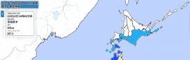
Severe Tropical Cyclone Narelle to bring severe impacts to Far North Queensland during Friday and the eastern Northern Territory later Saturday.

Area affected
Warning zone
Cape York Peninsula between Lockhart River and Cape Flattery, and between Mapoon and Pormpuraaw, including Coen, Weipa, and Aurukun.

Watch zone
Nhulunbuy to Port McArthur, including Borroloola, Numbulwar, Alyangula, Ngukurr and Bulman.

Cancelled zone
None.

At 3:30 am Australian Central Standard Time
At 3:30 am ACST

Intensity
category 4, sustained winds near the centre of 195 kilometres per hour with wind gusts to 270 kilometres per hour

Location
within 30 kilometres of 13.7 degrees South, 144.2 degrees East, 110 kilometres east of Coen and 840 kilometres east of Alyangula

Movement
west at 21 kilometres per hour

Severe Tropical Cyclone Narelle, category 4, moving westwards to cross the Far North Queensland coast between Lockhart River and Cape Melville on Friday morning.

Narelle is forecast to move over Cape York Peninsula as a tropical cyclone during Friday while weakening. Narelle will then continue to move west across the Gulf of Carpentaria, and expected to strengthen again to a severe tropical cyclone before impacting the eastern Northern Territory from late Saturday.

Hazards

Queensland:

VERY DESTRUCTIVE WIND GUSTS in excess of 250 km/h are possible near the centre of Severe Tropical Cyclone Narelle as it crosses the Cape York Peninsula coast on Friday morning.

DESTRUCTIVE WIND GUSTS to 160 km/h are likely south of Lockhart River to north of Cape Flattery this morning. DESTRUCTIVE WIND GUSTS are likely to persist near the centre of Narelle as it moves across Cape York Peninsula during Friday.

Gales with DAMAGING WIND GUSTS to 120 km/h are likely from Cape Flattery to north of Lockhart River. Gales with DAMAGING WIND GUSTS to 120 km/h are also forecast to extend across Cape York Peninsula, including areas between Mapoon and Pormpuraaw, during Friday.

HEAVY RAINFALL which may lead to FLASH FLOODING with LOCALLY INTENSE RAINFALL is likely in an area of the Cape York Peninsula bounded by Lockhart River, Cape Flattery, Pormpuraaw, and Weipa during Friday.

Tides will be higher than normal between Coen and Cape Flattery as Narelle approaches and crosses the coast. LARGE WAVES may produce MINOR FLOODING of low-lying coastal areas. There is a small risk that tides may approach the highest tide of the year during Friday.

Tides in Princess Charlotte Bay are likely to rise significantly above the normal high tide, with DAMAGING WAVES and DANGEROUS FLOODING. Any coastal residents in this area are specifically warned of a possible DANGEROUS STORM TIDE as the cyclone centre crosses the coast.

Once Narelle moves into the Gulf of Carpentaria, tides on the western Peninsula between Weipa and Kowanyama may be higher than normal. LARGE WAVES may produce MINOR FLOODING of low-lying coastal areas.

Northern Territory:

GALES are not expected in coastal areas in the next 24 hours, however gales are expected to develop in coastal areas between Port McArthur and Nhulunbuy from Saturday afternoon as Narelle approaches from the east, and extend inland to areas including Ngukurr on Saturday night or early Sunday morning. VERY DESTRUCTIVE winds are possible near the centre of the cyclone on Saturday night.

HEAVY RAINFALL which may lead to FLASH FLOODING is possible for coastal and adjacent inland areas over the eastern Top End between Port McArthur and south of Nhulunbuy from late Saturday.

Tides will be higher than normal between Nhulunbuy and Port McArthur later Saturday and Sunday. LARGE WAVES may produce MINOR FLOODING of low-lying coastal areas. A potentially DANGEROUS STORM TIDE between Alyangula and Port Roper is possible as the cyclone centre crosses the coast with DAMAGING WAVES and DANGEROUS FLOODING.


Recommended action
Queensland:

- People in the path of the very dangerous cyclone should stay calm and remain in a secure shelter - above the expected water level - while the very destructive winds continue.

- Do not venture outside if you find yourself in the eye of the cyclone - very destructive winds from a different direction could resume at any time.

- There may be powerlines down, broken glass and other hazards.

- Follow the instructions and advice of Police, Emergency Services personnel and local authorities.

- Stay informed by checking your local government¿s Disaster Dashboards for the latest updates.

IF YOUR LIFE IS IN DANGER PHONE TRIPLE ZERO (000) IMMEDIATELY.

- Stay informed by checking your local government¿s Disaster Dashboards for the latest updates.

- For cyclone preparedness and safety advice, visit the Get Ready Queensland website www.getready.qld.gov.au

- For non-life threatening emergency assistance contact State Emergency Services (SES) online via the SES Assistance QLD App, Apple , Android, online www.132500.qld.gov.au, or call 132 500 from anywhere in Queensland.

Northern Territory:

NTES advises:

People between Port MacArthur and Nhulunbuy, and inland to Ngukurr, should consider what action they will need to take if the cyclone threat increases.

- For cyclone preparedness and safety advice, visit the Secure NT website at http://www.securent.nt.gov.au

- For emergency assistance call the Northern Territory Emergency Service (NTES) on 132 500 (for assistance with storm damage, rising flood water, fallen trees on buildings or roof damage).
C4.png
c7bcd998-8970-4ba0-9e39-a04da2bd7b17.png
NARELLE_tc_ec_ens.png
rb-animated.gif
回復

使用道具 舉報

快速回覆
您需要登錄後才可以回帖 登錄 | 立即加入

本版積分規則

本平台僅供學術討論之用,預報應以氣象局為準

威普網站虛擬主機贊助公司

臺灣第一個天氣類型社群平台 即時天氣資訊、精準颱風動態

線上客服
FB傳送訊息
廣告行銷
精準行銷 物超所值
官方粉專
發佈 快速回復 返回頂部 返回列表