簽到天數: 4654 天 [LV.Master]伴壇終老
|
本帖最後由 alu 於 2026-7-1 01:09 編輯
基本資料
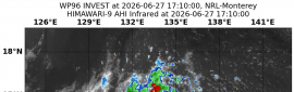
編號 :95 E
擾動編號日期:2026 年 06 月 30 日 02 時
撤編日期 :2026 年 07 月 00 日 00 時
EP, 95, 2026062918, , BEST, 0, 116N, 1230W, 20, 1008, DB, 34, NEQ


ZCZC MIATWOEP ALL
TTAA00 KNHC DDHHMM
Tropical Weather Outlook
NWS National Hurricane Center Miami FL
500 AM PDT Tue Jun 30 2026
For the eastern and central North Pacific east of 180 longitude:
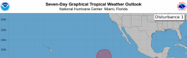
1. Western East Pacific (EP95):
A broad area of low pressure located well southwest of the southern
tip of the Baja California Peninsula is producing showers and
thunderstorms that are showing signs of organization. Gradual
development of this system is expected during the next couple of
days, and a tropical depression is likely to form tonight or on
Wednesday while the system moves generally northwestward and then
northward.
* Formation chance through 48 hours...high...80 percent.
* Formation chance through 7 days...high...80 percent.
Forecaster Adams/Papin
|
|

 提升卡
提升卡 千斤頂
千斤頂 照妖鏡
照妖鏡