|
|
 krichard2011|2014-4-10 15:09
|
顯示全部樓層
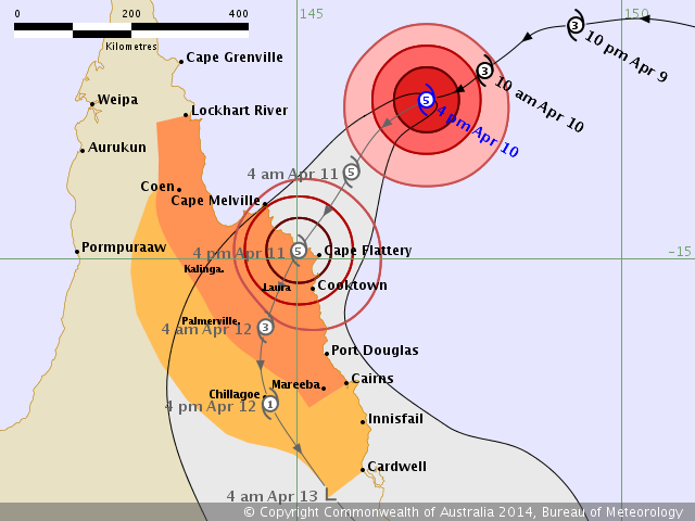
爆發增強 短短幾個小時從澳式C3
增強到現在的澳式C5 @@
而且預測還還會持續增強..
不排除挑戰今年南太風季最強
此外JTWC也升格C4 (115 kts)

IDQ20018
TROPICAL CYCLONE TECHNICAL BULLETIN: AUSTRALIA - EASTERN REGION
Issued by BRISBANE TROPICAL CYCLONE WARNING CENTRE
at: 0656 UTC 10/04/2014
Name: Severe Tropical Cyclone Ita
Identifier: 15U
Data At: 0600 UTC
Latitude: 12.6S
Longitude: 147.0E
Location Accuracy: within 5 nm [15 km]
Movement Towards: west southwest [243 deg]
Speed of Movement: 10 knots [18 km/h]
Maximum 10-Minute Wind: 110 knots [205 km/h]
Maximum 3-Second Wind Gust: 155 knots [285 km/h]
Central Pressure: 935 hPa
Radius of 34-knot winds NE quadrant: 90 nm [165 km]
Radius of 34-knot winds SE quadrant: 100 nm [185 km]
Radius of 34-knot winds SW quadrant: 100 nm [185 km]
Radius of 34-knot winds NW quadrant: 90 nm [165 km]
Radius of 48-knot winds NE quadrant: 50 nm [95 km]
Radius of 48-knot winds SE quadrant: 50 nm [95 km]
Radius of 48-knot winds SW quadrant: 50 nm [95 km]
Radius of 48-knot winds NW quadrant: 50 nm [95 km]
Radius of 64-knot winds: 30 nm [55 km]
Radius of Maximum Winds: 15 nm [25 km]
Dvorak Intensity Code: T6.5/6.5/D1.0/24HRS
Pressure of outermost isobar: 1004 hPa
Radius of outermost closed isobar: 150 nm [280 km]
FORECAST DATA
Date/Time : Location : Loc. Accuracy: Max Wind : Central Pressure
[UTC] : degrees : nm [km]: knots[km/h]: hPa
+06: 10/1200: 13.0S 146.3E: 020 [035]: 115 [215]: 928
+12: 10/1800: 13.7S 145.8E: 030 [055]: 120 [220]: 922
+18: 11/0000: 14.3S 145.4E: 045 [080]: 120 [220]: 922
+24: 11/0600: 14.9S 145.0E: 055 [105]: 120 [220]: 922
+36: 11/1800: 16.1S 144.5E: 075 [140]: 080 [150]: 964
+48: 12/0600: 17.2S 144.6E: 095 [175]: 035 [065]: 996
+60: 12/1800: 18.6S 145.5E: 115 [215]: 030 [055]: 1000
+72: 13/0600: 19.9S 147.4E: 135 [250]: 030 [055]: 1001
+96: 14/0600: 22.1S 152.6E: 180 [330]: 030 [055]: 1000
+120: 15/0600: 24.0S 156.4E: 265 [495]: 030 [055]: 998
REMARKS:
Dvorak analysis of Severe Tropical Cyclone Ita was based on an eye pattern with
a white surround and an added 0.5 for a dark grey eye combined with a white
surround, giving a DT of 6.5. The average DT over the last 3 hours is 6.5 also.
MET and PAT both give 6.0.
Severe Tropical Cyclone Ita has intensified significantly today with the system
now exhibiting a clear eye pattern on the recent satellite imagery. Deep
convection has developed further near the inner core of the system with very
cold cloud top temperatures now surrounding a well defined warm eye in the
infrared satellite imagery. The system remains situated in a low vertical wind
shear environment with sea surface temperatures greater than 28 degrees. CIMSS
upper winds depict very good outflow above the system, which has allowed
intensification to occur today. ADT is following this intensifying trend with a
greater than a 100 knot system being analysed.
Severe Tropical Cyclone Ita is being steered towards the west-southwest under
the influence of a mid-level ridge extending across the central Coral Sea and up
over the Solomon Islands. The system has been moving faster than forecast and
quicker than any of the computer model guidance is indicating, so therefore some
persistence has been paid to the short term forecast track. The mid-level ridge
is expected to erode into Friday, which should then lead to the system
developing a southwest track prior to landfall along the far north Queensland
coast. Most of the global computer models are now indicating that the system
will cross the far north Queensland coast late Friday between Cape Melville and
Cooktown. |
|