開啟輔助訪問
 找回密碼
 立即加入

14L.Matthew 北大9年來首個五級颶風 吹襲加勒比海周邊國家

簽到天數: 3279 天

[LV.Master]伴壇終老

t02436|2016-10-2 11:13 | 顯示全部樓層
中心開始減速滯留,準備轉向。
rb-animated.gif

20161002.0006.f18.91pct91h91v.14L.MATTHEW.130kts.942mb.13.2N.73.3W.055pc.jpg

21Z升回130節,03Z維持評價,只不過路徑再向東調整,換海地遭殃了:L。
ZCZC MIATCDAT4 ALL
TTAA00 KNHC DDHHMM

HURRICANE MATTHEW DISCUSSION NUMBER  15
NWS NATIONAL HURRICANE CENTER MIAMI FL       AL142016
500 PM EDT SAT OCT 01 2016

Matthew's cloud pattern has improved this afternoon, with the small
eye becoming more distinct.  A NOAA hurricane hunter aircraft
recently found peak SFMR winds of around 130 kt, and a peak
7,000-ft flight-level wind of 135 kt.
The initial intensity is
raised to 130 kt for this advisory.  The wind field has contracted
today, and the radius of maximum winds is now about 6 n mi.  The
latest minimum pressure based on a dropsonde from the aircraft is
940 mb.  Radar imagery from the NOAA plane suggests that an outer
eyewall may be forming, but the current eye has been resilient
today.  Some gradual net weakening is expected during the next day
or so, but Matthew is expected to remain a powerful hurricane until
it begins to interact with the landmasses of Jamaica, eastern Cuba,
and Hispaniola in 48 to 72 hours.  Some weakening is expected during
that time, but conditions appear conducive for restrengthening once
Matthew moves into the Bahamas late in the forecast period.  The NHC
forecast is well above the intensity consensus through much of the
period.  Note that there will likely be short-term fluctuations in
intensity like we've seen today due to internal dynamics, including
eyewall replacement cycles, that are not shown here.

Matthew has made a small cyclonic loop since the last advisory, and
the initial motion estimate is a northwestward drift at around 3 kt.
The mid-level ridge centered near Bermuda is expected to weaken and
shift eastward, causing Matthew to turn northward while it moves
into a weakness in the ridge during the forecast period.  The track
model guidance has shifted a little to the east in the short range,
and the NHC track during this time has been adjusted in that
direction, in agreement with the latest multi-model consensus.

Late in the period the track model spread remains considerable, as
the global models continue to have issues depicting the synoptic-
scale pattern over the eastern United States and western Atlantic in
4-5 days.  The evolution of the mid/upper-level low currently
centered over the Ohio Valley and how it interacts with the western
Atlantic subtropical ridge appear to be critical to the long-term
track of Matthew.  The UKMET and ECMWF tracks have shifted westward
and slower by day 5, while the GFS has trended east.  This has
narrowed the guidance envelope somewhat, but given the lack of
run-to-run consistency I'd hesitate to say that confidence in the
long-range track forecast has increased by any appreciable measure.
The new NHC track at these times leans heavily on continuity, and by
day 5 is close to the GFS/ECMWF blend and left of the latest
multi-model consensus aid TVCN.

It is important to remind users that average NHC track forecast
errors are around 175 miles at day 4 and 230 miles at day 5.
Therefore, it is too soon to rule out possible hurricane impacts
from Matthew in Florida.

FORECAST POSITIONS AND MAX WINDS

INIT  01/2100Z 13.5N  73.4W  130 KT 150 MPH
12H  02/0600Z 13.6N  73.8W  125 KT 145 MPH
24H  02/1800Z 14.8N  74.4W  120 KT 140 MPH
36H  03/0600Z 16.1N  74.9W  115 KT 130 MPH
48H  03/1800Z 17.6N  75.0W  110 KT 125 MPH
72H  04/1800Z 21.0N  75.0W   95 KT 110 MPH
96H  05/1800Z 24.5N  75.5W  100 KT 115 MPH
120H  06/1800Z 26.5N  76.0W  100 KT 115 MPH

$$
Forecaster Brennan

NNNN

025316W_sm.gif

20161002.0215.goes-13.ircolor.14L.MATTHEW.130kts.940mb.13.5N.73.4W.100pc.jpg

點評

長腫瘤  發表於 2016-10-2 17:51
這旋臂真奇葩XD  發表於 2016-10-2 13:49
怎覺得外圍雲系的對流比中心附近還強啊?  發表於 2016-10-2 12:06
回復

使用道具 舉報

簽到天數: 582 天

[LV.9]以壇為家II

蜜露|2016-10-2 19:43 | 顯示全部樓層
本帖最後由 蜜露 於 2016-10-2 19:44 編輯


(上圖) 馬修        940hPa  140kts
(下圖) 菲尼克斯 929hPa 145kts

近10年來菲尼克斯是大西洋最有霸氣感覺.
20160930.2315.goes13.x.ir1km_bw.14LMATTHEW.110kts-955mb-135N-713W.100pc.jpg


20070902.2315.goes12.x.ir1km_bw.06LFELIX.120kts-NAmb-134N-725W.100pc.jpg


點評

ktf
馬修北上後有可能成為今年為止風場最大的熱帶氣旋  發表於 2016-10-2 20:15
ktf
馬修表示:不急,北上後和高壓梯度加成後,會變成超大風場氣勢強大的環流  發表於 2016-10-2 20:14
Felix中文音譯不是費利克斯嗎?怎麼變菲尼克斯(Fenix)了?另外這颶風最佳路徑強度不是給予150kts了嗎?  發表於 2016-10-2 20:04
回復

使用道具 舉報

簽到天數: 3279 天

[LV.Master]伴壇終老

t02436|2016-10-4 13:44 | 顯示全部樓層
NHC根據實測再調升強度至125節,12小時之後將擦過海地西岸,一天後登陸古巴。
000
WTNT44 KNHC 040257
TCDAT4

HURRICANE MATTHEW DISCUSSION NUMBER  24
NWS NATIONAL HURRICANE CENTER MIAMI FL       AL142016
1100 PM EDT MON OCT 03 2016

An Air Force Reserve Hurricane Hunter aircraft this evening measured
two peak SFMR winds of 125 kt in the northeastern eyewall, along
with a peak flight-level wind of 129 kt. The lowest pressure
measured by a dropsonde has been 934 mb, down 6 mb since the
previous flight. Based on these data, the initial intensity has been
increased to 125 kt.

Matthew continues to move a little east of due north, or 010/07 kt.
There is no change to the previous short-term track forecast
reasoning. Matthew is expected to move northward around the western
periphery of a strong deep-layer ridge for the next 24 hours,
followed by a north-northwestward motion at 36 and 48 hours. That
portion of the new forecast track is essentially the same as the
previous advisory, bringing Matthew over the southwestern peninsula
of Haiti tonight and near or over eastern Cuba on Tuesday. Beyond 48
hours, the GFS has again trended westward, and now lies closer to
the UKMET model track. This change might be related to the
mid-/upper-level trough currently located over the eastern Gulf of
Mexico, which is now forecast to split, with the northern portion
lifting out to the northeast and dissipating while the southern
portion cuts of into a low pressure system that drops southward over
the northwestern Caribbean Sea by 36-48 hours.   The new track
forecast has again been shifted westward closer to Florida, and lies
near a blend of the 18Z GFS and 12Z ECMWF model solutions.

Only slight weakening is expected during the next couple of days due
to Matthew interacting with the land masses of western Haiti and
eastern Cuba. After the hurricane emerges over the Atlantic waters
between Cuba and the Bahamas, low vertical wind shear and warm SSTs
of near 30C should help Matthew to recover some before southwesterly
wind shear increases by 96-120 hours and induces a faster rate of
weakening. The new NHC intensity forecast is basically identical to
the previous advisory, and closely follows the consensus model IVCN.

KEY MESSAGES:

1.  Matthew is likely to produce devastating impacts from storm
surge, extreme winds, heavy rains, flash floods, and/or mudslides in
portions of the watch and warning areas in Haiti, Cuba, and the
Bahamas.  Please consult statements from the meteorological services
and other government officials in those countries.

2.  Direct hurricane impacts are possible in Florida later this
week.  Tropical storm and/or hurricane watches are likely tomorrow
morning for portions of the Florida peninsula and the Florida Keys.

3.  Tropical storm or hurricane conditions could affect portions of
Georgia, South Carolina, and North Carolina later this week or this
weekend, even if the center of Matthew remains offshore.  It is too
soon to specify what, if any, direct impacts Matthew might have on
the remainder of the U.S. east coast farther north.  At a minimum,
very dangerous beach and boating conditions are likely along much of
the U.S. east coast later this week and weekend.

FORECAST POSITIONS AND MAX WINDS

INIT  04/0300Z 16.9N  74.6W  125 KT 145 MPH
12H  04/1200Z 18.3N  74.5W  125 KT 145 MPH
24H  05/0000Z 20.0N  74.4W  120 KT 140 MPH
36H  05/1200Z 21.8N  75.2W  115 KT 130 MPH
48H  06/0000Z 23.4N  76.2W  110 KT 125 MPH
72H  07/0000Z 26.6N  78.7W  105 KT 120 MPH
96H  08/0000Z 30.0N  79.6W  100 KT 115 MPH
120H  09/0000Z 33.3N  77.6W   90 KT 105 MPH

$$
Forecaster Stewart

NHC TRACK 100403Z.png

14L.png

底層還是相當強悍...
20161004.0236.metopb.89rgb.14L.MATTHEW.125kts.934mb.16.6N.74.6W.090pc.jpg

實測目前持續進行中,最新SMFR測得126節風速,保重了...
044400 1716N 07418W 6984 02666 9474 +139 //// 176115 122 124 002 01
044430 1716N 07417W 6966 02720 9538 +133 //// 175128 132 126 006 01
044500 1716N 07416W 6980 02738 9567 +131 //// 172135 136 126 005 01
044530 1716N 07414W 6965 02780 9611 +128 +128 171129 135 120 013 03

recon_AF306-1814A-MATTHEW.png

recon_AF306-1814A-MATTHEW_timeseries.png

rbtop-animated.gif

點評

的確  發表於 2016-10-4 19:52
結果現在的中心氣壓比140kts時還來的低,再次證明風速和氣壓並非絕對的關係  發表於 2016-10-4 15:27
回復

使用道具 舉報

簽到天數: 3279 天

[LV.Master]伴壇終老

t02436|2016-10-4 20:14 | 顯示全部樓層
接近陸地時可能受到地形影響而東偏,直接撲向海地,稍早以125節強度正式登陸。
ZCZC MIATCPAT4 ALL
TTAA00 KNHC DDHHMM

BULLETIN
HURRICANE MATTHEW INTERMEDIATE ADVISORY NUMBER  25A
NWS NATIONAL HURRICANE CENTER MIAMI FL       AL142016
800 AM EDT TUE OCT 04 2016

...EYE OF EXTREMELY DANGEROUS HURRICANE MATTHEW MADE LANDFALL NEAR
LES ANGLAIS IN WESTERN HAITI AT 7 AM EDT THIS MORNING...


SUMMARY OF 800 AM EDT...1200 UTC...INFORMATION
----------------------------------------------
LOCATION...18.4N 74.2W
ABOUT 10 MI...15 KM E OF TIBURON HAITI
ABOUT 125 MI...200 KM S OF THE EASTERN TIP OF CUBA
MAXIMUM SUSTAINED WINDS...145 MPH...230 KM/H
PRESENT MOVEMENT...N OR 5 DEGREES AT 9 MPH...15 KM/H
MINIMUM CENTRAL PRESSURE...934 MB...27.58 INCHES


WATCHES AND WARNINGS
--------------------
CHANGES WITH THIS ADVISORY:

None.

SUMMARY OF WATCHES AND WARNINGS IN EFFECT:

A Hurricane Warning is in effect for...
* Haiti
* Cuban provinces of Guantanamo, Santiago de Cuba, Holguin, Granma,
and Las Tunas
* Southeastern Bahamas, including the Inaguas, Mayaguana, Acklins,
Crooked Island, Long Cay, and Ragged Island
* Central Bahamas, including Long Island, Exuma, Rum Cay,
San Salvador, and Cat Island
* Northwestern Bahamas, including the Abacos, Andros Island,
Berry Islands, Bimini, Eleuthera, Grand Bahama Island, and
New Providence

A Hurricane Watch is in effect for...
* Cuban province of Camaguey

A Tropical Storm Warning is in effect for...
* Dominican Republic from Barahona westward to the border with Haiti
* Jamaica
* Turks and Caicos Islands

A Tropical Storm Watch is in effect for...
* Dominican Republic from Puerto Plata westward to the border with
Haiti

Interests elsewhere in Hispaniola and in the Florida Peninsula and
the Florida Keys should monitor the progress of Matthew.  Tropical
storm and/or hurricane watches are likely for portions of the
Florida peninsula and Florida Keys later this morning.

For storm information specific to your area, please monitor products
issued by your national meteorological service.


DISCUSSION AND 48-HOUR OUTLOOK
------------------------------
At 800 AM EDT (1200 UTC), the eye of Hurricane Matthew was located
inland Haiti near latitude 18.4 North, longitude 74.2 West. Matthew
made landfall near Les Anglais about 700 AM EDT (1100 UTC).  The
hurricane is moving toward the north near 9 mph (15 km/h), and this
general motion is expected to continue today.  On this track the eye
of Matthew will be back over water in the Gulf of Gonave in the next
hour or so, and then move over the Windward Passage later this
morning.  A turn toward the north-northwest is expected by
Wednesday, followed by a northwest turn Wednesday night. On the
forecast track, the eye of Matthew will move near eastern Cuba later
today, and move near or over portions of the southeastern and
central Bahamas tonight and Wednesday, and approach the northwestern
Bahamas Wednesday night

Maximum sustained winds remain near 145 mph (230 km/h) with
higher gusts.  Matthew is a category 4 hurricane on the Saffir-
Simpson Hurricane Wind Scale.  Some fluctuations in intensity are
possible during the next couple of days, but Matthew is expected to
remain a powerful hurricane through at least Wednesday night.

Hurricane-force winds extend outward up to 40 miles (65 km) from
the center and tropical-storm-force winds extend outward up to 185
miles (295 km).

The estimated minimum central pressure is 934 mb (27.58 inches).


HAZARDS AFFECTING LAND
----------------------
WIND:  Hurricane conditions are already affecting the southwestern
portion of Haiti, and these conditions will spread northward today.
Hurricane conditions are expected to reach eastern Cuba later today,
the southeastern Bahamas Tuesday evening, the central Bahamas on
Wednesday, and the northwestern Bahamas Wednesday night.  Tropical
storm conditions are expected to continue spreading across the
remainder of Haiti today, eastern Cuba later this morning, the
southeastern Bahamas later today, and the central and northwestern
Bahamas Tuesday night and Wednesday, making outside preparations
difficult or dangerous.

Tropical storm conditions are expected in portions of Jamaica and
along the southern coast of the Dominican Republic within the
warning area today, and will spread northward into the Turks
and Caicos Islands tonight.

Hurricane conditions are possible in the hurricane watch areas in
Cuba tonight with tropical storm conditions possible later today.

RAINFALL:  Matthew is expected to produce total rainfall amounts in
the following areas:

Southern Haiti and southwestern Dominican Republic...15 to 25
inches, isolated 40 inches
Eastern Cuba and northwestern Haiti...8 to 12 inches, isolated
20 inches
Eastern Jamaica...4 to 6 inches, isolated 10 inches
The Bahamas...8 to 12 inches, isolated 15 inches
Turks and Caicos Islands...2 to 5 inches, isolated 8 inches
Northeastern Haiti and the Northern Dominican Republic...1 to 3
inches, isolated 5 inches
Western Jamaica...1 to 2 inches, isolated 3 inches

Life-threatening flash floods and mudslides are likely from this
rainfall in southern and northwestern Haiti, the southwestern
Dominican Republic, and eastern Cuba.

STORM SURGE:  The combination of a dangerous storm surge and large
and destructive waves could raise water levels by as much as the
following amounts above normal tide levels...

Southern Coast of Cuba east of Cabo Cruz...7 to 11 feet
South Coast of Haiti...7 to 10 feet
Northern Coast of Cuba east of Camaguey...4 to 6 feet
Jamaica...2 to 4 feet
Gulf of Gonave in Haiti...3 to 5 feet
Southern coast of the Dominican Republic...1 to 3 feet
The Bahamas...10 to 15 feet

Surge-related flooding depends on the relative timing of the surge
and the tidal cycle, and can vary greatly over short distances.
Large waves generated by Matthew will cause water rises to occur
well in advance of and well away from the track of the center.

SURF:  Swells generated by Matthew will continue to affect portions
of the coasts of Hispaniola, Jamaica, eastern Cuba, and the
Caribbean coastline of Central America during the next few
days.  Swells from Matthew will begin affecting portions of the
Bahamas on Tuesday.  These swells are likely to cause life-
threatening surf and rip current conditions.  Please consult
products from your local weather office.


NEXT ADVISORY
-------------
Next complete advisory at 1100 AM EDT.

$$
Forecaster Avila

NNNN

114739W_sm.gif

20161004.0902.f16.91pct91h91v.14L.MATTHEW.125kts.934mb.17.4N.74.5W.095pc.jpg

登陸前動圖存檔
rbtop-animated.gif

vis-animated.gif

rb-animated.gif

點評

為甚麼有一種被土拉庫輾過的感覺  發表於 2016-10-5 00:16
好強悍的底層!  發表於 2016-10-4 22:18
回復

使用道具 舉報

簽到天數: 3279 天

[LV.Master]伴壇終老

t02436|2016-10-5 00:43 | 顯示全部樓層
稍早中心已經出海,15Z評價還是維持登陸前的125節,Matthew表示:海地陸地根本小case:L
目前預測下一站:古巴,再來貫穿巴哈馬群島橫掃美東沿岸,都貼著海岸走....
000
WTNT44 KNHC 041506
TCDAT4

HURRICANE MATTHEW DISCUSSION NUMBER  26
NWS NATIONAL HURRICANE CENTER MIAMI FL       AL142016
1100 AM EDT TUE OCT 04 2016

The eye of Hurricane Matthew was quite distinct when it made
landfall near Les Anglais, Haiti at 1100 UTC this morning,
but since that time the eye has become obscured on conventional
imagery. A reconnaissance plane measured SFMR winds of 118 kt
earlier today, but the entire area has not been sampled yet by the
plane. On this basis, the initial intensity is kept at 125 kt in
this advisory. Some slight weakening could occur today while Matthew
interacts with the high terrain of Cuba and Haiti, but the
environment is favorable for the hurricane to maintain category 4
status for the next 2 days.  Some weakening is anticipated by the
end of the forecast period due to an increase of the wind shear.


Radar fixes from Cuba and satellite data indicate that Matthew is
moving toward the north or 360 degrees at about 9 kt.  The hurricane
is being steered by the flow around the western edge of a
subtropical ridge. Most of the global models build the ridge
westward, and this pattern should force the hurricane to turn
toward the northwest across the Bahamas and to the waters just east
of Florida. Beyond 3 days, the ridge is forecast to shift eastward
allowing Matthew to turn northward and then northeastward.
Users are reminded not to focus on the exact forecast track since
strong winds, heavy rainfall, and a dangerous storm surge will
extend far from the center of Matthew. Most of the models shows a
strong hurricane near the east coast of Florida and the southeast
United States from days 2 through 5.


KEY MESSAGES:

1.  Matthew is likely to produce devastating impacts from storm
surge, extreme winds, heavy rains, flash floods, and/or mudslides in
portions of the watch and warning areas in Haiti, Cuba, and the
Bahamas.  Please consult statements from the meteorological services
and other government officials in those countries.

2.  Direct hurricane impacts are possible in Florida later this
week.  Tropical storm and/or hurricane watches have been issued
for portions of the Florida peninsula and the Florida Keys.

3.  Tropical storm or hurricane conditions could affect portions of
Georgia, South Carolina, and North Carolina later this week or this
weekend, even if the center of Matthew remains offshore.  It is too
soon to specify what, if any, direct impacts Matthew might have on
the remainder of the U.S. east coast farther north.  At a minimum,
very dangerous beach and boating conditions are likely along much of
the U.S. east coast later this week and weekend.


FORECAST POSITIONS AND MAX WINDS

INIT  04/1500Z 18.9N  74.3W  125 KT 145 MPH
12H  05/0000Z 20.3N  74.3W  125 KT 145 MPH
24H  05/1200Z 22.0N  74.7W  115 KT 130 MPH
36H  06/0000Z 24.0N  76.0W  115 KT 130 MPH
48H  06/1200Z 25.6N  77.4W  115 KT 130 MPH
72H  07/1200Z 29.5N  79.7W  110 KT 125 MPH
96H  08/1200Z 34.0N  78.5W   90 KT 105 MPH...INLAND
120H  09/1200Z 39.5N  72.5W   80 KT  90 MPH

$$
Forecaster Avila

153536W_sm.gif

高層眼雖然被陸地弄糊了,但底層眼還完好健在
rbtop-animated.gif

Matthew_4-5Oct16_cuba.gif

Matthew_3-4Oct16_gpd.gif

第19次飛機實測持續進行,現正穿心中
五分鐘前的最新數據仍支持SMFR 120節風速
163430 1916N 07409W 6969 02779 9626 +124 +124 135082 096 113 037 03
163500 1915N 07410W 6971 02755 9598 +124 //// 127070 076 117 009 01
163530 1914N 07411W 6967 02735 9530 +125 //// 122059 067 120 001 05
163600 1912N 07412W 6971 02717 9524 +136 +128 116045 056 110 001 00

recon_AF303-1914A-MATTHEW_timeseries.png

recon_AF303-1914A-MATTHEW.png
回復

使用道具 舉報

簽到天數: 3279 天

[LV.Master]伴壇終老

t02436|2016-10-5 09:42 | 顯示全部樓層
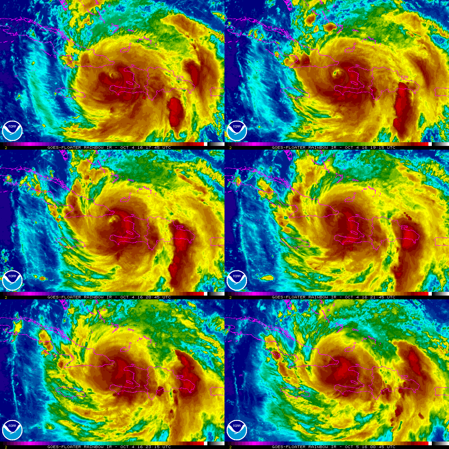
Matthew挾近中心120節風速再次強勢登陸古巴。
000
WTNT34 KNHC 042354
TCPAT4

BULLETIN
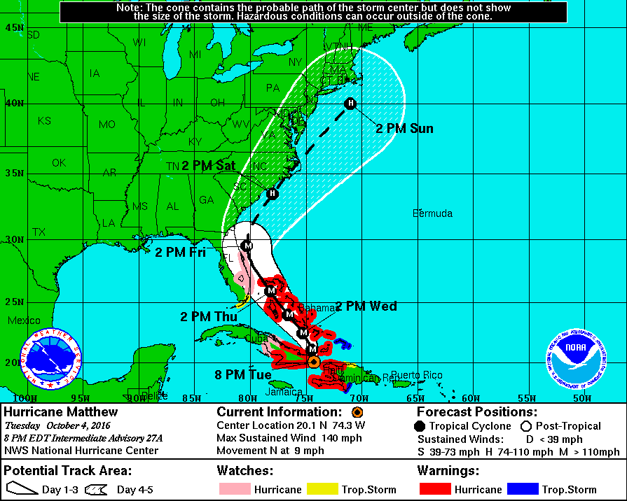
HURRICANE MATTHEW INTERMEDIATE ADVISORY NUMBER  27A
NWS NATIONAL HURRICANE CENTER MIAMI FL       AL142016
800 PM EDT TUE OCT 04 2016

...THE EYE OF POWERFUL HURRICANE MATTHEW MAKING LANDFALL NEAR THE
EASTERN TIP OF CUBA...


SUMMARY OF 800 PM EDT...0000 UTC...INFORMATION
----------------------------------------------
LOCATION...20.1N 74.3W
ABOUT 15 MI...20 KM SW OF THE EASTERN TIP OF CUBA
ABOUT 55 MI...90 KM ENE OF GUANTANAMO CUBA
MAXIMUM SUSTAINED WINDS...140 MPH...220 KM/H
PRESENT MOVEMENT...N OR 360 DEGREES AT 9 MPH...15 KM/H
MINIMUM CENTRAL PRESSURE...949 MB...28.03 INCHES


WATCHES AND WARNINGS
--------------------
CHANGES WITH THIS ADVISORY:

None.

SUMMARY OF WATCHES AND WARNINGS IN EFFECT:

A Hurricane Warning is in effect for...
* Haiti
* Cuban provinces of Guantanamo, Santiago de Cuba, Holguin, Granma,
and Las Tunas
* Southeastern Bahamas, including the Inaguas, Mayaguana, Acklins,
Crooked Island, Long Cay, and Ragged Island
* Central Bahamas, including Long Island, Exuma, Rum Cay,
San Salvador, and Cat Island
* Northwestern Bahamas, including the Abacos, Andros Island,
Berry Islands, Bimini, Eleuthera, Grand Bahama Island, and
New Providence

A Hurricane Watch is in effect for...
* Cuban province of Camaguey
* Golden Beach to the Volusia/Brevard county line
* Lake Okeechobee

A Tropical Storm Warning is in effect for...
* Dominican Republic from Barahona westward to the border with Haiti
* Turks and Caicos Islands

A Tropical Storm Watch is in effect for...
* Dominican Republic from Puerto Plata westward to the border with
Haiti
* Seven Mile Bridge to south of Golden Beach

Interests elsewhere in the Florida Peninsula and the Florida Keys
should monitor the progress of Matthew.

For storm information specific to your area in the United
States, including possible inland watches and warnings, please
monitor products issued by your local National Weather Service
forecast office. For storm information specific to your area outside
the United States, please monitor products issued by your national
meteorological service.


DISCUSSION AND 48-HOUR OUTLOOK
------------------------------
At 800 PM EDT (0000 UTC), radar data from Guantanamo, Cuba, along
with reports from an Air Force Reserve Hurricane Hunter aircraft,
indicate that the eye of Hurricane Matthew was located near latitude
20.1 North, longitude 74.3 West.  The center of the eye of Matthew
made landfall near Juaco, Cuba, around 800 PM EDT (0000 UTC).
Matthew is moving toward the north near 9 mph (15 km/h), and this
motion is expected to continue through this evening. A turn toward
the north-northwest is expected on Wednesday, followed by a
northwest turn Wednesday night.  Matthew is forecast to move near or
over portions of the southeastern and central Bahamas Wednesday, and
approach the northwestern Bahamas Wednesday night.

Maximum sustained winds are near 140 mph (220 km/h) with higher
gusts. Matthew remains a category 4 hurricane on the Saffir-Simpson
Hurricane Wind Scale.  Some fluctuations in intensity are possible
during the next couple of days, but Matthew is expected to remain a
powerful hurricane through at least Thursday night.

Hurricane-force winds extend outward up to 45 miles (75 km) from
the center and tropical-storm-force winds extend outward up to 175
miles (280 km).

The minimum central pressure recently reported by reconnaissance
aircraft was 949 mb (28.03 inches).


HAZARDS AFFECTING LAND
----------------------
WIND:  Hurricane conditions are still affecting portions of
Haiti. Hurricane conditions are likely occuring over eastern Cuba,
and will begin in the southeastern Bahamas by Wednesday morning, the
central Bahamas on Wednesday, and the northwestern Bahamas Wednesday
night.

Tropical storm conditions are expected to continue spreading
across the remainder of Haiti, eastern Cuba and the southeastern
Bahamas tonight, and should reach the central and northwestern
Bahamas on Wednesday, making outside preparations difficult or
dangerous. Tropical storm conditions are still occurring in portions
the Dominican Republic within the warning area, and these conditions
will spread northward into the Turks and Caicos Islands tonight.

Hurricane conditions are possible in the hurricane watch areas in
Cuba tonight with tropical storm conditions possible later tonight.

Hurricane conditions are possible within the hurricane watch
area in Florida by late Thursday, with tropical storm conditions
possible by early Thursday. Tropical storm condition are also
possible in the Florida tropical storm watch area by early Thursday.

RAINFALL:  Matthew is expected to produce total rainfall amounts in
the following areas:

Southern Haiti and southwestern Dominican Republic...15 to 25
inches, isolated 40 inches
Eastern Cuba and northwestern Haiti...8 to 12 inches, isolated
20 inches
Eastern Jamaica...4 to 6 inches, isolated 12 inches
The Bahamas...8 to 12 inches, isolated 15 inches
Turks and Caicos Islands...2 to 5 inches, isolated 8 inches
Northeastern Haiti and the Northern Dominican Republic...1 to 3
inches, isolated 5 inches
Western Jamaica...1 to 2 inches, isolated 3 inches
Upper Florida Keys northward to coastal east-central Florida....4 to
7 inches, isolated 10 inches
Middle to Lower Florida Keys....1 to 3 inches, isolated 5 inches

Life-threatening flash floods and mudslides are likely from this
rainfall in southern and northwestern Haiti, the southwestern
Dominican Republic, and eastern Cuba.

STORM SURGE:  The combination of a dangerous storm surge and large
and destructive waves could raise water levels by as much as the
following amounts above normal tide levels...

Southern Coast of Cuba east of Cabo Cruz...7 to 11 feet
South Coast of Haiti...7 to 10 feet
Northern Coast of Cuba east of Camaguey...4 to 6 feet
Gulf of Gonave in Haiti...3 to 5 feet
Southern coast of the Dominican Republic...1 to 3 feet
The Bahamas...10 to 15 feet

The water could reach the following heights above ground if the peak
surge occurs at the time of high tide...

North Palm Beach to the Volusia/Brevard county line...3 to 5 ft

Surge-related flooding depends on the relative timing of the surge
and the tidal cycle, and can vary greatly over short distances.
Large waves generated by Matthew will cause water rises to occur
well in advance of and well away from the track of the center.

The combination of a dangerous storm surge and the tide will cause
normally dry areas near the coast to be flooded by rising waters
moving inland from the shoreline.  There is the potential for
life-threatening inundation during the next 48 hours along
the Florida east coast from North Palm Beach to the Volusia/Brevard
county line.  For a depiction of areas at risk, please see the
Prototype National Weather Service Storm Surge Watch/Warning
Graphic.  For information specific to your area, please see products
issued by your local National Weather Service forecast office.

The Prototype Storm Surge Watch/Warning Graphic is a depiction of
areas that would qualify for inclusion under a storm surge watch or
warning currently under development by the National Weather Service
and planned for operational use in 2017.  The Prototype Graphic is
available at hurricanes.gov.

SURF:  Swells generated by Matthew will continue to affect portions
of the coasts of Hispaniola, Jamaica, eastern Cuba, and the
Caribbean coastline of Central America during the next few
days.  Swells from Matthew will begin affecting portions of the
Bahamas on Tuesday.  These swells are likely to cause life-
threatening surf and rip current conditions.  Please consult
products from your local weather office.


NEXT ADVISORY
-------------
Next complete advisory at 1100 PM EDT.

$$
Forecaster Stewart
213032W_sm.gif

rb-animated.gif

點評

中心離開古巴東部之後重新開眼 這颶風真狂  發表於 2016-10-5 23:15
回復

使用道具 舉報

簽到天數: 3279 天

[LV.Master]伴壇終老

t02436|2016-10-6 00:40 | 顯示全部樓層
下午穿越古巴進入巴哈馬群島南方海域,終究抵不過地形的破壞,15Z降到C3下限的105節。
然而,NHC仍然支持Matthew回到C4等級,後期路徑因為Nicole的出現而有了明顯的變化,很有可能出現奇葩路徑....
000
WTNT44 KNHC 051454
TCDAT4

HURRICANE MATTHEW DISCUSSION NUMBER  30
NWS NATIONAL HURRICANE CENTER MIAMI FL       AL142016
1100 AM EDT WED OCT 05 2016

Both NOAA and Air Force Hurricane Hunter planes have been in the eye
of Matthew during the past several hours.  Data from those planes
indicate that the hurricane is gradually recovering from the
passage over the mountains of eastern Cuba and Haiti. The eye is
becoming better defined on satellite. Based on SFMR winds of
103 kt and a flight-level peak wind of 118 kt, the initial
intensity is 105 kt.

The environment between the Bahamas and Florida is favorable for
Matthew to restrengthen some during the next couple of days.
After that time, the shear is forecast to increase, resulting in
gradual weakening.

Fixes from the planes indicate that Matthew is moving toward the
northwest or 325 degrees at about 8 to 10 kt. The subtropical ridge
over the western Atlantic is amplifying as anticipated by the
global models.  The flow pattern around this ridge should continue
to steer the hurricane toward the northwest during the next day or
two with no significant change in forward speed. After that time
the ridge will move east allowing Matthew to move northward very
near or over the Florida east coast and then near or to the east of
the Georgia and South Carolina coasts. By the end of the forecast
period, models have changed significantly since yesterday.
Some track models keep the hurricane moving eastward across the
Atlantic while the GFS and the ECMWF reduce the hurricane's forward
speed with a southward turn. This change in these two valuable
models is reflected in the current NHC forecast.

KEY MESSAGES:

1.  Matthew is likely to produce devastating impacts from storm
surge, extreme winds, heavy rains, flash floods, and/or mudslides in
portions of the hurricane warning areas in Cuba and the Bahamas.
Please consult statements from the meteorological services and other
government officials in those countries.

2.  When a hurricane is forecast to take a track roughly parallel
to a coastline, as Matthew is forecast to do from Florida through
South Carolina, it becomes very difficult to specify impacts at
any one location.  For example, only a small deviation of the track
to the left of the NHC forecast could bring the core of a major
hurricane onshore within the hurricane warning area in Florida.
However, a small deviation to the right could keep the hurricane-
force winds offshore.

3.  Tropical storm or hurricane conditions could affect Georgia,
South Carolina, and North Carolina later this week or this weekend,
even if the center of Matthew remains offshore.  It is too soon to
determine what, if any, land areas might be directly affected by
Matthew next week.  At a minimum, dangerous beach and boating
conditions are likely along much of the U.S. east coast during the
next several days.

4.  The National Hurricane Center is issuing Potential Storm Surge
Flooding Maps, and Prototype Storm Surge Watch/Warning Graphics for
Matthew.  It is important to remember that the Potential Storm Surge
Flooding Map does not represent a forecast of expected inundation,
but rather depicts a reasonable worst-case scenario - the amount of
inundation that has a 10 percent chance of being exceeded.  In
addition, because the Flooding Map is based on inputs that extend
out only to about 72 hours, it best represents the flooding
potential in those locations within the watch and warning areas.

FORECAST POSITIONS AND MAX WINDS

INIT  05/1500Z 21.8N  75.2W  105 KT 120 MPH
12H  06/0000Z 23.1N  76.0W  110 KT 125 MPH
24H  06/1200Z 24.8N  77.5W  115 KT 130 MPH
36H  07/0000Z 26.6N  79.0W  115 KT 130 MPH
48H  07/1200Z 28.2N  80.1W  115 KT 130 MPH
72H  08/1200Z 31.5N  80.0W   95 KT 110 MPH
96H  09/1200Z 32.5N  76.0W   85 KT 100 MPH
120H  10/1200Z 32.0N  74.0W   70 KT  80 MPH

$$
Forecaster Avila

153139W_sm.gif

西側底層明顯破裂,等待修補,但可見光雲圖仍然可見高層眼
20161005.1203.f18.91pct91h91v.14L.MATTHEW.100kts.964mb.21.5N.74.9W.100pc.jpg

20161005.1615.goes-13.vis.1km.14L.MATTHEW.105kts.964mb.21.8N.75.2W.100pc.jpg

古巴雷達
Matthew_4-5Oct16_cuba.gif

第23次實測進行中,SMFR:105Kts
recon_AF304-2314A-MATTHEW_timeseries.png

recon_AF304-2314A-MATTHEW.png

rbtop-animated.gif

評分

參與人數 1水氣能量 +30 收起 理由
ben811018 + 30

查看全部評分

回復

使用道具 舉報

簽到天數: 588 天

[LV.9]以壇為家II

Meow|2016-10-6 21:27 | 顯示全部樓層
Suomi NPP擷取10月1日加勒比海巔峰後的颶風Matthew。

Matthew 2016-10-01 1800Z.jpg
https://commons.wikimedia.org/wi ... 016-10-01_1800Z.jpg

評分

參與人數 1水氣能量 +20 收起 理由
ben811018 + 20

查看全部評分

回復

使用道具 舉報

快速回覆
您需要登錄後才可以回帖 登錄 | 立即加入

本版積分規則

本平台僅供學術討論之用,預報應以氣象局為準

威普網站虛擬主機贊助公司

臺灣第一個天氣類型社群平台 即時天氣資訊、精準颱風動態

線上客服
FB傳送訊息
廣告行銷
精準行銷 物超所值
官方粉專
發佈 快速回復 返回頂部 返回列表