開啟輔助訪問
 找回密碼
 立即加入

02E.Barbara 發展超乎預期達C4頂 後進中太減弱消散

簽到天數: 582 天

[LV.9]以壇為家II

蜜露|2019-7-3 09:31 | 顯示全部樓層
本帖最後由 蜜露 於 2019-7-3 10:03 編輯

芭芭菈還有增強的趨勢,他的模樣很像西太的颱風。

眼溫達到了+21.2  加上環境不錯 未來極限強度可能會維持一陣子或剛好達到Cat.5


2019EP02_4KMIRIMG_201907030100.gif


20190703.0025.f16.91pct91h91v.02E.BARBARA.135kts.933mb.13N.124W.070pc.jpg

20190703.0025.f16.91h.02E.BARBARA.135kts.933mb.13N.124W.070pc.jpg

wg9sht.GIF


回復

使用道具 舉報

簽到天數: 1650 天

[LV.Master]伴壇終老

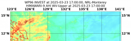
老農民版夜神月|2019-7-5 02:04 | 顯示全部樓層
NHC0415Z,Barbara強度已被判定為三級颶風下限(100KT),強度有持續減弱的趨勢
000
WTPZ42 KNHC 041436
TCDEP2

Hurricane Barbara Discussion Number 17
NWS National Hurricane Center Miami FL EP022019
500 AM HST Thu Jul 04 2019

Satellite images indicate that Barbara continues to gradually
weaken. Convection in the eyewall is becoming less intense, with
eye temperatures slowly falling. A consensus of the latest
satellite estimates suggests 100 kt as the initial wind speed.
The hurricane is entering an environment that will likely promote
rapid weakening during the next couple of days. Barbara is forecast
to traverse sub-26C waters and encounter increasing southwesterly
shear, which would help to mix in drier air from the mid-levels of
the atmosphere. Thus, the cyclone should weaken to a tropical storm
by 36 hours and degenerate into a post-tropical cyclone around
the time it enters the Central Pacific basin. The new NHC
prediction is similar to the previous one and is a bit lower than
the model consensus.

Barbara has turned northwestward recently, and is moving about
310/10 kt. This general path is forecast until tomorrow when a
mid-level ridge builds to north of the cyclone, causing a
west-northwestward motion. As Barbara weakens, it should
turn westward on Saturday, steered by the low-level flow. Model
guidance is in very good agreement on this scenario, and no
significant changes were required to the previous forecast. All of
the model dissipate the cyclone east of the Hawaiian Islands,
although the remnants could move across that area in about 5 days.


FORECAST POSITIONS AND MAX WINDS

INIT 04/1500Z 16.0N 130.0W 100 KT 115 MPH
12H 05/0000Z 17.0N 131.2W 85 KT 100 MPH
24H 05/1200Z 18.1N 133.0W 70 KT 80 MPH
36H 06/0000Z 18.9N 135.2W 50 KT 60 MPH
48H 06/1200Z 19.2N 137.8W 40 KT 45 MPH
72H 07/1200Z 19.0N 143.8W 30 KT 35 MPH...POST-TROP/REMNT LOW
96H 08/1200Z 18.8N 150.5W 30 KT 35 MPH...POST-TROP/REMNT LOW
120H 09/1200Z...DISSIPATED

$$
Forecaster Blake

004105iajo87c8aphjoohp.png 未命名00705.png
未命名0705.png 20190704.1248.f16.rain.02E.BARBARA.100kts.960mb.15.7N.129.6W.095pc.jpg
20190704.1248.f16.91h.02E.BARBARA.100kts.960mb.15.7N.129.6W.095pc.jpg

回復

使用道具 舉報

簽到天數: 3279 天

[LV.Master]伴壇終老

t02436|2019-7-6 01:08 | 顯示全部樓層
前方環境惡劣,15Z已降TS,看來要以TS強度進中太越來越難。
947
WTPZ42 KNHC 051432
TCDEP2

Tropical Storm Barbara Discussion Number  21
NWS National Hurricane Center Miami FL       EP022019
500 AM HST Fri Jul 05 2019

Strong southwesterly shear and marginal SSTs are causing Barbara to
continue to weaken.  The associated deep convection, which is
displaced to the northeast of the cyclone center, is diminishing in
both coverage and intensity.  Using a blend of Dvorak Current
Intensity and T-numbers from TAFB and SAB results in an advisory
intensity estimate of 60 kt.  Since the shear is expected to
increase further, continued weakening is likely and Barbara should
degenerate into a remnant low in 48 hours or sooner.  The official
intensity forecast is near or above the latest model consensus.

The initial motion estimate is 305/11 kt.  A low- to mid-level
ridge is forecast to build to the north of Barbara over the next
couple of days.  As a result, the cyclone should turn toward the
west-northwest and west during the next 24 to 48 hours.  The
official track forecast is similar to the previous one, and very
close to the simple and corrected model consensus tracks.

FORECAST POSITIONS AND MAX WINDS

INIT  05/1500Z 18.4N 133.6W   60 KT  70 MPH
12H  06/0000Z 18.8N 135.4W   50 KT  60 MPH
24H  06/1200Z 19.2N 138.1W   40 KT  45 MPH
36H  07/0000Z 19.3N 141.0W   30 KT  35 MPH
48H  07/1200Z 19.1N 144.3W   25 KT  30 MPH...POST-TROP/REMNT LOW
72H  08/1200Z 19.0N 151.5W   20 KT  25 MPH...POST-TROP/REMNT LOW
96H  09/1200Z...DISSIPATED

$$
Forecaster Pasch

143337_5day_cone_with_line.png

20190705.1406.f18.91pct91h91v.02E.BARBARA.65kts.987mb.18.1N.133.1W.080pc.jpg

GOES16502019186THRWXv.jpg

GOES16502019186UOjUmx.jpg

goes17_truecolor_02E_201907051645.jpg
回復

使用道具 舉報

12
快速回覆
您需要登錄後才可以回帖 登錄 | 立即加入

本版積分規則

本平台僅供學術討論之用,預報應以氣象局為準

威普網站虛擬主機贊助公司

臺灣第一個天氣類型社群平台 即時天氣資訊、精準颱風動態

線上客服
FB傳送訊息
廣告行銷
精準行銷 物超所值
官方粉專
發佈 快速回復 返回頂部 返回列表