A tropical low, 1003 hPa, was located near Groote Eylandt at 13.9S 136.5E, at 12:30pm CST [1:00pm EST]. The tropical low is expected to move southeastwards across the southern Gulf of Carpentaria during the weekend, then become slow moving near the southeastern Gulf of Carpentaria early next week. The low could then move westwards and towards the Northern Territory, or continue moving southeastwards towards Queensland. The chance of a tropical cyclone forming in the Gulf of Carpentaria increases next week.
Likelihood of a tropical cyclone in the Northern Region on:
Saturday:Very Low
Sunday: Low
Monday:Moderate
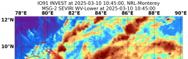
(1) THE AREA OF CONVECTION (INVEST 97P) HAS PERSISTED NEAR
14.8S 137.0E, APPROXIMATELY 161 NM NORTHWEST OF MORNINGTON ISLAND,
AUSTRALIA. ANIMATED MULTISPECTRAL SATELLITE IMAGERY (MSI) DEPICTS
POCKETS OF FLARING CONVECTION BEGINNING TO CONSOLIDATE AROUND A LOW
LEVEL CIRCULATION CENTER (LLCC). A 010931Z SSMIS 91GHZ SATELLITE
IMAGE DEPCITS DISTINCT POCKETS OF DEEP CONVECTION PRIMARILY OVER
LAND. UPPER LEVEL ANALYSIS INDICATES INVEST 97P IS IN A FAVORABLE
ENVIRONMENT FOR DEVELOPMENT WITH POLEWARD OUTFLOW ALOFT, VERY WARM
(30-31C) SEA SURFACE TEMPERATURES (SST), AND LOW TO MODERATE (10-20
KT) VERTICAL WIND SHEAR. GLOBAL MODELS ARE IN GENERAL AGREEMENT THAT
INVEST 97P WILL TRACK SOUTHEASTWARD OVER THE GULF OF CARPENTARIA AS
IT CONSOLIDATES AND STRENGTHENS. MAXIMUM SUSTAINED SURFACE WINDS ARE
ESTIMATED AT 15 TO 20 KNOTS. MINIMUM SEA LEVEL PRESSURE IS ESTIMATED
TO BE NEAR 1002 MB. THE POTENTIAL FOR THE DEVELOPMENT OF A
SIGNIFICANT TROPICAL CYCLONE WITHIN THE NEXT 24 HOURS IS LOW.
TROPICAL CYCLONE ADVICE NUMBER 1
Issued at 11:19 am EST on Saturday 2 January 2021
Headline:
A tropical low over the western Gulf of Carpentaria is expected to move east-southeast and intensify during Sunday.
Areas Affected:
Warning Zone
None.
Watch Zone
NT/Qld Border to Pormpuraaw.
Cancelled Zone
None.
Details of Tropical Low at 10:00 am AEST [9:30 am ACST]:
Intensity: Tropical Low, sustained winds near the centre of 35 kilometres per hour with wind gusts to 75 kilometres per hour.
Location: within 55 kilometres of 14.7 degrees South 137.0 degrees East, estimated to be 230 kilometres north northwest of NT/Qld Border and 315 kilometres northwest of Mornington Island.
Movement: southeast at 7 kilometres per hour.
The tropical low may develop into a tropical cyclone during Sunday night over the far southern Gulf of Carpentaria.
The tropical low or cyclone is expected to move southeastwards and cross the southeastern Gulf coast during Monday.
Hazards:
GALES extending to 100 kilometres from the centre of the tropical low are expected to develop about coastal and island communities between NT/Qld Border and Kowanyama during Sunday night.
ABNORMALLY HIGH TIDES and large waves are expected about the southeastern Gulf and western Cape York Peninsula as the system approaches the coast.
HEAVY RAINFALL that may lead to flash flooding about the southeastern Gulf of Carpentaria, southern Cape York Peninsula and adjacent inland areas.
Recommended Action:
People between NT/Qld Border and Pormpuraaw should consider what action they will need to take if the cyclone threat increases.
- Information is available from your local government
- For cyclone preparedness and safety advice, visit Queensland's Disaster Management Services website (www.disaster.qld.gov.au)
- For emergency assistance call the Queensland State Emergency Service (SES) on 132 500 (for assistance with storm damage, rising flood water, fallen trees on buildings or roof damage).
Next Advice:
The next advice will be issued by 5:00 pm AEST Saturday 02 January.
IDQ20018
TROPICAL CYCLONE TECHNICAL BULLETIN: AUSTRALIA - EASTERN REGION
Issued by AUSTRALIAN BUREAU OF METEOROLOGY TROPICAL CYCLONE WARNING CENTRE
at: 0727 UTC 02/01/2021
Name: Tropical Low
Identifier: 05U
Data At: 0600 UTC
Latitude: 15.2S
Longitude: 137.4E
Location Accuracy: within 30 nm [55 km]
Movement Towards: southeast [143 deg]
Speed of Movement: 5 knots [9 km/h]
Maximum 10-Minute Wind: 25 knots [45 km/h]
Maximum 3-Second Wind Gust: 45 knots [85 km/h]
Central Pressure: 1000 hPa
Radius of 34-knot winds NE quadrant:
Radius of 34-knot winds SE quadrant:
Radius of 34-knot winds SW quadrant:
Radius of 34-knot winds NW quadrant:
Radius of 48-knot winds NE quadrant:
Radius of 48-knot winds SE quadrant:
Radius of 48-knot winds SW quadrant:
Radius of 48-knot winds NW quadrant:
Radius of 64-knot winds:
Radius of Maximum Winds:
Dvorak Intensity Code: T1.5/1.5/D1.0/24HRS
Pressure of outermost isobar: 1004 hPa
Radius of outermost closed isobar: 70 nm [130 km]
FORECAST DATA
Date/Time : Location : Loc. Accuracy: Max Wind : Central Pressure
[UTC] : degrees : nm [km]: knots[km/h]: hPa
+06: 02/1200: 15.3S 137.7E: 040 [080]: 025 [045]: 1001
+12: 02/1800: 15.4S 138.1E: 055 [100]: 030 [055]: 999
+18: 03/0000: 15.7S 138.6E: 065 [125]: 030 [055]: 999
+24: 03/0600: 16.0S 139.3E: 080 [145]: 030 [055]: 999
+36: 03/1800: 16.5S 140.3E: 100 [180]: 035 [065]: 995
+48: 04/0600: 16.8S 141.0E: 120 [220]: 045 [085]: 990
+60: 04/1800: 17.0S 141.4E: 140 [255]: 030 [055]: 998
+72: 05/0600: 16.8S 141.7E: 155 [290]: 025 [045]: 1000
+96: 06/0600: 17.1S 141.9E: 200 [370]: 025 [045]: 1000
+120: 07/0600: 17.8S 142.3E: 290 [535]: 020 [035]: 1003
REMARKS:
Tropical low has been located using surface observations and visual satellite
imagery indicating an organised cloud system centre. An area of deep convection
has persisted to the south of the centre in the last 12 hours, which has spread
into a convective band around the analysis time giving a wrap of 0.5 degree on
Log 10 spiral. Hence, Dvorak DT was assessed at T2.5. The Final T was assessed
as 1.5.
The tropical low is being fed by low to mid level moist cross-equatorial
northwesterly flow moving across the north of Indonesia. VW imagery indicates
deep levels of moisture. The low is under an upper level ridge with 10-15 knots
shear and favourable outflow channel located to the south and a weaker return
flow to the north.
The chances of further organisation and development in the next 24 to 36 hours
is assessed as good, based on the current forecast track of the low remaining
over water.
The low is expected to be steered steadily towards the southeast due to the low
level northwesterly flow. As the low deepens, the southeast movement may
continue to be encouraged due to an amplifying upper trough to the southwest of
the system. Hence, the tropical cyclone may persist on track to cross the coast
during Monday.
Longer term movement is uncertain as the influence of the upper trough weakens
once the cyclone makes landfall. Global models begin to diverge with some
indicating it remains over land as a deep tropical low or perhaps even move back
over eastern Gulf of Carpentaria waters, where favourable conditions exist for
re-development.
Copyright Commonwealth of Australia
==
The next bulletin for this system will be issued by: 02/1330 UTC.
WTPS21 PGTW 022000
MSGID/GENADMIN/JOINT TYPHOON WRNCEN PEARL HARBOR HI//
SUBJ/TROPICAL CYCLONE FORMATION ALERT (INVEST 97P)//
RMKS/
1. FORMATION OF A SIGNIFICANT TROPICAL CYCLONE IS POSSIBLE WITHIN
130 NM EITHER SIDE OF A LINE FROM 15.9S 138.2E TO 17.6S 142.6E
WITHIN THE NEXT 12 TO 24 HOURS. AVAILABLE DATA DOES NOT JUSTIFY
ISSUANCE OF NUMBERED TROPICAL CYCLONE WARNINGS AT THIS TIME.
WINDS IN THE AREA ARE ESTIMATED TO BE 25 TO 30 KNOTS. METSAT
IMAGERY AT 021800Z INDICATES THAT A CIRCULATION CENTER IS LOCATED
NEAR 16.0S 138.4E. THE SYSTEM IS MOVING SOUTHEASTWARD AT 06
KNOTS.
2. REMARKS: THE AREA OF CONVECTION (INVEST 97P) PREVIOUSLY LOCATED
NEAR 15.6S 137.7E IS NOW LOCATED NEAR 16.0S 138.4E, APPROXIMATELY 59
NM NORTHWEST OF MORNINGTON ISLAND, AUSTRALIA. ANIMATED ENHANCED
INFRARED SATELLITE IMAGERY, RADAR IMAGERY, AND A 021245Z METOP-B
89GHZ MICROWAVE IMAGE DEPICT FORMATIVE BANDING WRAPPING INTO A
CONSOLIDATING LOW LEVEL CIRCULATION CENTER WITH FLARING CONVECTION
THROUGHOUT. ENVIRONMENTAL ANALYSIS REVEALS INVEST 97P IS IN A
FAVORABLE ENVIRONMENT FOR DEVELOPMENT WITH LOW TO MODERATE (15-
20KTS) VERTICAL WIND SHEAR, STRONG OUTFLOW ALOFT, WARM (30-31C) SEA
SURFACE TEMPERATURES. GLOBAL MODELS ARE IN GENERAL AGREEMENT THAT
INVEST 97P WILL CONTINUE TO TRACK EAST-SOUTHEASTWARD WHILE STEADILY
INTENSIFYING. NEAR TAU 24 THE SYSTEM IS EXPECTED TO MAKE LANDFALL,
BECOME QUASI-STATIONARY AND BEGIN DISSIPATING. MAXIMUM SUSTAINED
SURFACE WINDS ARE ESTIMATED AT 25 TO 30 KNOTS. MINIMUM SEA LEVEL
PRESSURE IS ESTIMATED TO BE NEAR 998 MB. THE POTENTIAL FOR THE
DEVELOPMENT OF A SIGNIFICANT TROPICAL CYCLONE WITHIN THE NEXT 24
HOURS IS HIGH.
3. THIS ALERT WILL BE REISSUED, UPGRADED TO WARNING OR CANCELLED BY
032000Z.//
NNNN


 提升卡
提升卡 千斤頂
千斤頂


.png")


.png")