開啟輔助訪問
 找回密碼
 立即加入

09P.Imogen 南太2021年首旋 近岸命名 登陸澳洲

簽到天數: 1650 天

[LV.Master]伴壇終老

老農民版夜神月|2021-1-3 14:44 | 顯示全部樓層
BoM升格澳式C1,命名Imogen
TROPICAL CYCLONE ADVICE NUMBER 7
Issued at 4:40 pm EST on Sunday 3 January 2021

Headline:
Tropical Cyclone Imogen has formed in the southeast Gulf and is expected to continue moving southeast.

Areas Affected:
Warning Zone
Mornington Island to Kowanyama, including Burketown and inland areas to Croydon.

Watch Zone
None.

Cancelled Zone
Kowanyama to Pormpuraaw.

Details of Tropical Cyclone Imogen at 4:00 pm AEST:
Intensity: Category 1, sustained winds near the centre of 65 kilometres per hour with wind gusts to 100 kilometres per hour.

Location: within 20 kilometres of 16.6 degrees South 139.6 degrees East, estimated to be 130 kilometres north of Burketown and 165 kilometres northwest of Karumba.

Movement: southeast at 12 kilometres per hour.

Tropical Cyclone Imogen is expected to move towards the east southeast and cross the southeast Gulf coast near Karumba tonight, or early Monday morning. Once Imogen makes landfall, it will become slow-moving over the southern Cape York Peninsula as a tropical low.


93D292DCED4987823ED3FE253FAE66CB.jpg 20210103.0610.himawari-8.vis.97P.INVEST.30kts.999mb.16.3S.139.1E.100pc.jpg

回復

使用道具 舉報

簽到天數: 1650 天

[LV.Master]伴壇終老

老農民版夜神月|2021-1-3 15:15 | 顯示全部樓層
本帖最後由 老農民版夜神月 於 2021-1-6 01:00 編輯

JTWC升格09P
09P IMOGEN 210103 0600 16.8S 139.9E SHEM 35 996

sh0921.gif
20210103.0640.himawari-8.vis.09P.INVEST.35kts.996mb.16.8S.139.9E.100pc.jpg IDQ65001 (3).png
回復

使用道具 舉報

簽到天數: 483 天

[LV.9]以壇為家II

dom|2021-1-3 21:45 | 顯示全部樓層
命名後不到幾小時BoM判定Imogen在當地晚上10時以35節的風速登陸,登陸前亦曾經發展出底層眼

Details of Tropical Cyclone Imogen at 10:00 pm AEST:

Intensity: category 1, sustained winds near the centre of 65 kilometres per hour with wind gusts to 100 kilometres per hour.
Location: within 20 kilometres of 17.4 degrees South, 140.9 degrees East , 10 kilometres northeast of Karumba and 230 kilometres south southwest of Kowanyama .
Movement: southeast at 18 kilometres per hour .

Tropical cyclone Imogen has recently crossed the Gulf of Carpentaria coast just to the north of Karumba. Imogen is expected to continue moving east-southeastwards in the short term, taking it further inland tonight and Monday, and is expected to transition to a tropical low in the next few hours. Longer term, the system is expected to track more slowly to the southeast over the southern Cape York Peninsula as a deep tropical low.
IDA00041.png IDQ65001.png 8a0eccbf6c81800a68c57548a63533fa828b472e.jpg 01f9a40f4bfbfbed1135cb396ff0f736aec31fda.jpg 02b83d6d55fbb2fbb9faa654584a20a44723dc7e.jpg.png
回復

使用道具 舉報

簽到天數: 483 天

[LV.9]以壇為家II

dom|2021-1-3 21:51 來自手機 | 顯示全部樓層
JTWC發佈Final Warning,登陸強度45節
381E26BD-228B-4DF6-9E4E-9F9292720AC3.gif
回復

使用道具 舉報

簽到天數: 483 天

[LV.9]以壇為家II

dom|2021-1-4 09:32 | 顯示全部樓層
BoM將其降格為Ex-TC
Headline:

Tropical cyclone Imogen has weakened to a tropical low but remains a dangerous system with widespread flooding rainfall expected over northern Queensland.


Areas affected:

Warning zone: None.

Watch zone: None.

Cancelled zones: Inland eastern Gulf Country including Croydon..


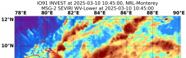
Details of Ex-Tropical Cyclone Imogen at 10:00 am AEST:

Intensity: tropical low, sustained winds near the centre of 55 kilometres per hour with wind gusts to 85 kilometres per hour.
Location: within 35 kilometres of 17.7 degrees South, 142.4 degrees East , 60 kilometres north northeast of Croydon and 140 kilometres east of Normanton .
Movement: east southeast at 14 kilometres per hour .

Tropical cyclone Imogen has now weakened into a tropical low. The low is expected to continue moving east-southeastwards in the short term, taking it further inland today. Longer term, the system is expected to track more slowly to the southeast towards the North Tropical and Herbert-Lower Burdekin coasts.


Hazards:

GALES with wind gusts to 90 km/h have eased about the tropical low. However, DAMAGING and LOCALLY DESTRUCTIVE winds are still possible with thunderstorms in the area - refer to the Severe Weather Warning.

HEAVY RAINFALL that is likely to lead to flash flooding, flooding of low lying areas and riverine flooding is expected to continue near and to the east of the tropical low for the next few days. Refer to the Severe Weather Warning for more details.


Recommended Action:

- For cyclone preparedness and safety advice, visit Queensland's Disaster Management Services website (www.disaster.qld.gov.au)

- For emergency assistance call the Queensland State Emergency Service (SES) on 132 500 (for assistance with storm damage, rising flood water, fallen trees on buildings or roof damage).
IDQ65001.png
回復

使用道具 舉報

簽到天數: 1650 天

[LV.Master]伴壇終老

老農民版夜神月|2021-1-6 10:25 | 顯示全部樓層
JTWC0130Z評級Low
(1) AN AREA OF CONVECTION (REMNANTS OF TC 09P) HAS PERSISTED NEAR
18.2S 146.1E, APPROXIMATELY 81 NM SOUTH-SOUTHEAST OF CAIRNS, AUSTRALIA.
ANIMATED MULTISPECTRAL SATELLITE IMAGERY AND A PARTIAL 052101Z MHS 89GHZ
MICROWAVE PASS, REVEAL AN AREA OF DEEP CONVECTION ASSOCIATED WITH THE
REMNANTS OF TC 09P MOVING OFF THE EAST COAST OF AUSTRALIA OVER
WATER. ENVIRONMENTAL ANALYSIS INDICATES THIS DISTURBANCE IS IN AN AREA
FAVORABLE FOR RE-INTENSIFICATION WITH ROBUST POLEWARD AND EASTWARD
OUTFLOW ALOFT, LOW (10-15KTS) VERTICAL WIND SHEAR, AND WARM (29-30C) SEA
SURFACE TEMPERATURES. MAXIMUM SUSTAINED SURFACE WINDS ARE ESTIMATED AT 15
TO 20 KNOTS. MINIMUM SEA LEVEL PRESSURE IS ESTIMATED TO BE NEAR 1003 MB.
THE POTENTIAL FOR THE DEVELOPMENT OF A SIGNIFICANT TROPICAL CYCLONE
WITHIN THE NEXT 24 HOURS IS UPGRADED TO LOW.
abpwsair - 2021-01-06T102113.579.jpg 20210106.0140.himawari-8.vis.09P.IMOGEN.20kts.1002mb.18.2S.146.1E.100pc.jpg
LATEST - 2021-01-06T102445.574.jpg
回復

使用道具 舉報

簽到天數: 1650 天

[LV.Master]伴壇終老

老農民版夜神月|2021-1-7 20:43 | 顯示全部樓層
09P已再次登陸澳洲,FNMOC12Z撤編
sfcplot_09P_latest.png
20210107.1150.himawari-8.ir.09P.IMOGEN.15kts.1007mb.20.3S.148E.100pc.jpg 09P_tracks_latest.png
回復

使用道具 舉報

簽到天數: 1650 天

[LV.Master]伴壇終老

老農民版夜神月|2021-1-7 22:11 | 顯示全部樓層
然後JTWC直到1400Z才取消評級
ABPW10 PGTW 071400
      (1) THE AREA OF CONVECTION (INVEST 09P) PREVIOUSLY LOCATED
NEAR 20.0S 147.8E HAS DISSIPATED AND IS NO LONGER SUSPECT FOR THE
DEVELOPMENT OF A SIGNIFICANT TROPICAL CYCLONE IN THE NEXT 24 HOURS.
20210107.134000.SH092021.ahi.himawari8.Infrared-Gray.15kts.100p0.1p0.jpg 09P_gefs_latest.png
回復

使用道具 舉報

12
快速回覆
您需要登錄後才可以回帖 登錄 | 立即加入

本版積分規則

本平台僅供學術討論之用,預報應以氣象局為準

威普網站虛擬主機贊助公司

臺灣第一個天氣類型社群平台 即時天氣資訊、精準颱風動態

線上客服
FB傳送訊息
廣告行銷
精準行銷 物超所值
官方粉專
發佈 快速回復 返回頂部 返回列表