IDQ20018
TROPICAL CYCLONE TECHNICAL BULLETIN: AUSTRALIA - EASTERN REGION
Issued by AUSTRALIAN BUREAU OF METEOROLOGY TROPICAL CYCLONE WARNING CENTRE
at: 1827 UTC 18/01/2021
Name: Ex-Tropical Cyclone Kimi
Identifier: 09U
Data At: 1800 UTC
Latitude: 18.3S
Longitude: 147.6E
Location Accuracy: within 30 nm [55 km]
Movement Towards: southeast [136 deg]
Speed of Movement: 1 knots [3 km/h]
Maximum 10-Minute Wind: 40 knots [75 km/h]
Maximum 3-Second Wind Gust: 55 knots [100 km/h]
Central Pressure: 998 hPa
Radius of 34-knot winds NE quadrant:
Radius of 34-knot winds SE quadrant:
Radius of 34-knot winds SW quadrant: 30 nm [55 km]
Radius of 34-knot winds NW quadrant:
Radius of 48-knot winds NE quadrant:
Radius of 48-knot winds SE quadrant:
Radius of 48-knot winds SW quadrant:
Radius of 48-knot winds NW quadrant:
Radius of 64-knot winds:
Radius of Maximum Winds:
Dvorak Intensity Code: T2.0/2.5/W1.0/24HRS STT:W0.5/06HRS
Pressure of outermost isobar: 1007 hPa
Radius of outermost closed isobar:
FORECAST DATA
Date/Time : Location : Loc. Accuracy: Max Wind : Central Pressure
[UTC] : degrees : nm [km]: knots[km/h]: hPa
+06: 19/0000: 18.4S 147.6E: 025 [050]: 030 [055]: 997
+12: 19/0600: 18.5S 147.5E: 040 [070]: 030 [055]: 998
+18: 19/1200: 18.3S 147.2E: 050 [095]: 030 [055]: 1000
+24: 19/1800: 18.0S 146.8E: 065 [120]: 030 [055]: 1001
+36: 20/0600: 17.2S 146.2E: 085 [155]: 025 [045]: 1003
+48: 20/1800: 16.5S 145.9E: 105 [190]: 025 [045]: 1003
+60: 21/0600: 15.8S 145.8E: 120 [225]: 025 [045]: 1003
+72: 21/1800: 15.0S 145.6E: 140 [265]: 025 [045]: 1003
+96: 22/1800: 14.4S 144.8E: 185 [345]: 025 [045]: 1002
+120: 23/1800: 14.4S 145.1E: 275 [505]: 025 [045]: 1003
REMARKS:
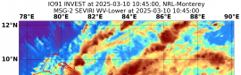
Tropical cyclone Kimi has displayed a weakening trend over the past 6 to 12
hours, with deep convection becoming confined exclusively to the southern side
of the centre and becoming more removed from the centre. The system has now been
reclassified as a tropical low. Centre fix is based on animated IR imagery,
surface observations and a 1522 UTC AMSR2 pass. Position is estimated as good.
Dvorak DT based on shear pattern with centre within 0.25 deg of cold overcast
giving DT 2.5. MET is 2.0 with PAT at 2.0. FT based on PT. Intensity is still
set at 35 knots [10-min mean] with a small patch of gales persisting in the SW
quadrant.
The environment rapidly became less favourable over the past 6 to 12 hours, with
vertical wind shear becoming west-northwesterly and increasing to about 20 knots
associated with the approach of an upper level trough to the south of the
system, and this is forecast to persist. Given its very small size, the system
responded rapidly to this environmental change, with analysis indicating the mid
to upper levels of the vortex have now weakened and decoupled from the low level
circulation.
With the recent structure changes and only a shallow vortex remaining, the
system has become slow-moving well off the coast over the past 6 hours.
Subsequent movement of a this shallower and weaker system is likely to be back
towards the north-northwest due to low level ridging building along the central
Queensland coast.
Copyright Commonwealth of Australia
==
There will be no further bulletins for this system unless it reintensifies
WTPS31 PGTW 182100
MSGID/GENADMIN/JOINT TYPHOON WRNCEN PEARL HARBOR HI//
SUBJ/TROPICAL CYCLONE 11P (KIMI) WARNING NR 008//
RMKS/
1. TROPICAL CYCLONE 11P (KIMI) WARNING NR 008
01 ACTIVE TROPICAL CYCLONE IN SOUTHPAC
MAX SUSTAINED WINDS BASED ON ONE-MINUTE AVERAGE
WIND RADII VALID OVER OPEN WATER ONLY
---
WARNING POSITION:
181800Z --- NEAR 17.7S 147.4E
MOVEMENT PAST SIX HOURS - 315 DEGREES AT 01 KTS
POSITION ACCURATE TO WITHIN 025 NM
POSITION BASED ON CENTER LOCATED BY A COMBINATION OF
SATELLITE, RADAR AND SYNOPTIC DATA
PRESENT WIND DISTRIBUTION:
MAX SUSTAINED WINDS - 035 KT, GUSTS 045 KT
WIND RADII VALID OVER OPEN WATER ONLY
DISSIPATING AS A SIGNIFICANT TROPICAL CYCLONE OVER WATER
RADIUS OF 034 KT WINDS - 070 NM NORTHEAST QUADRANT
055 NM SOUTHEAST QUADRANT
040 NM SOUTHWEST QUADRANT
045 NM NORTHWEST QUADRANT
REPEAT POSIT: 17.7S 147.4E
---
FORECASTS:
12 HRS, VALID AT:
190600Z --- 17.8S 147.3E
MAX SUSTAINED WINDS - 030 KT, GUSTS 040 KT
WIND RADII VALID OVER OPEN WATER ONLY
DISSIPATED AS A SIGNIFICANT TROPICAL CYCLONE OVER WATER
---
REMARKS:
182100Z POSITION NEAR 17.7S 147.4E.
18JAN21. TROPICAL CYCLONE 11P (KIMI), LOCATED APPROXIMATELY 103
NM EAST-SOUTHEAST OF CAIRNS, AUSTRALIA, HAS TRACKED NORTHWESTWARD
AT 01 KNOTS OVER THE PAST SIX HOURS.
THIS IS THE FINAL WARNING ON THIS SYSTEM BY THE JOINT TYPHOON
WRNCEN PEARL HARBOR HI. THE SYSTEM WILL BE CLOSELY MONITORED FOR
SIGNS OF REGENERATION. MAXIMUM SIGNIFICANT WAVE HEIGHT AT 181800Z
IS 12 FEET.
//
NNNN