開啟輔助訪問
 找回密碼
 立即加入

18E.Terry 發展不如預期

簽到天數: 1650 天

[LV.Master]伴壇終老

老農民版夜神月|2021-11-7 01:18 | 顯示全部樓層
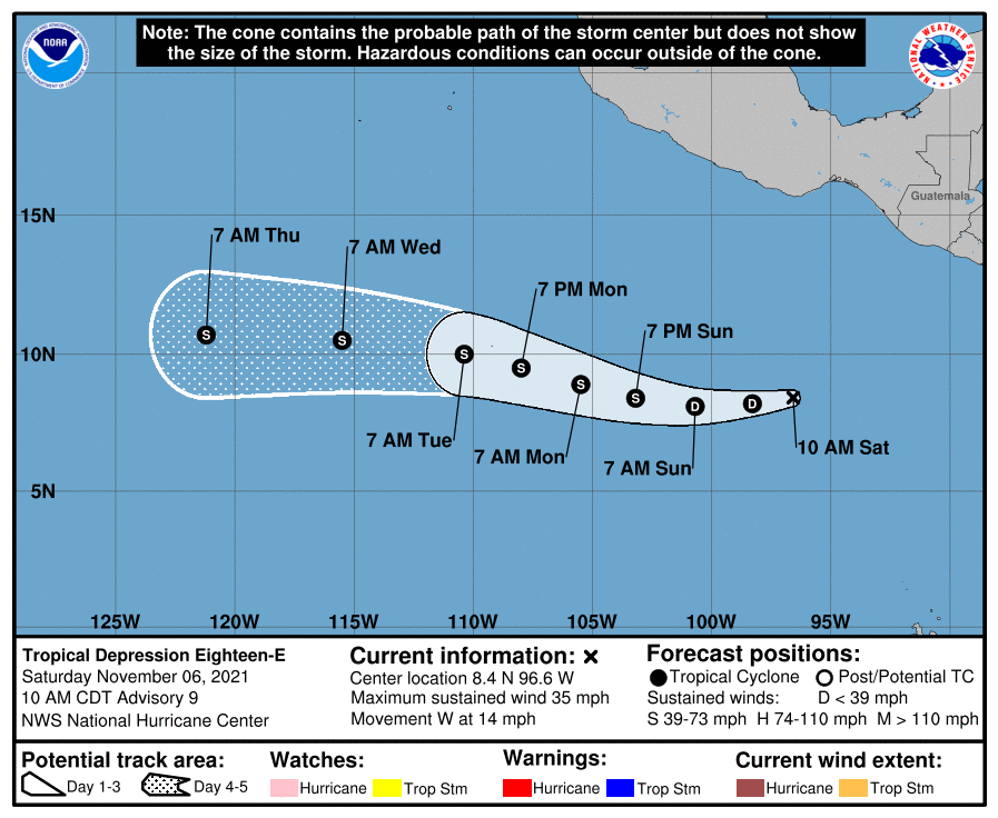
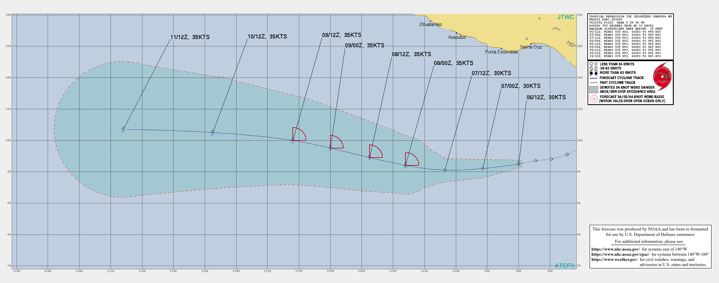
NHC下修預測巔峰為35KT ep1821 (2).gif 145022_5day_cone_no_line_and_wind.png
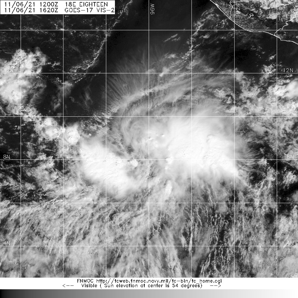
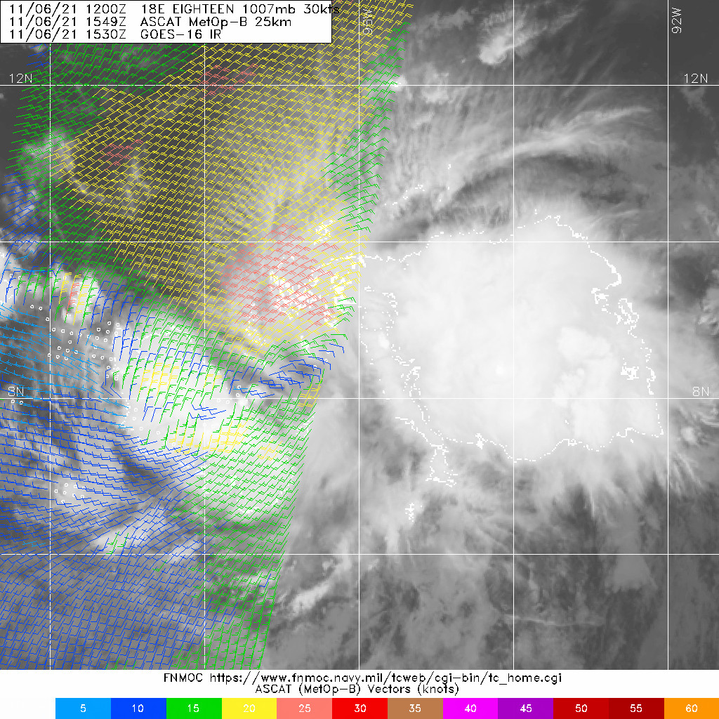
20211106.1620.goes-17.vis.2km.18E.EIGHTEEN.30kts.1007mb.8.5N.96W.pc.jpg 20211106.1549.mtb.ASCAT.wind.18E.EIGHTEEN.30kts-1007mb.85N.960W.25km.noqc.jpg

000
WTPZ43 KNHC 061453
TCDEP3

Tropical Depression Eighteen-E Discussion Number   9
NWS National Hurricane Center Miami FL       EP182021
1000 AM CDT Sat Nov 06 2021

After struggling to produce much in the way of deep convection
yesterday, a large nocturnal deep convective burst, with
overshooting cloud tops as cold as -85 C, occurred near the
estimated center of the depression, though this activity is
beginning to wane. An 0815 UTC AMSR2 microwave pass also
suggested modest organization under the cirrus, with some banding
features present in the deep convection. While last night's
scatterometer derived winds only topped out at 27 kt, the most
recent subjective Dvorak intensity estimate from TAFB is at T2.0/30
kt. The latest objective UW-CIMSS ADT estimate is even higher at
T2.5/35 kt. These estimates support bringing the intensity back up
to 30 kt for this advisory.

Using both scatterometer and microwave fixes, the depression has
maintained a south of due west heading over the past 12-24 hours,
with the latest motion estimated at 260/12 kt. This general heading
is expected to continue for the next several days with a gradual
bend poleward in the latter half of the forecast period as the
cyclone rounds the southern side of a expensive mid-level ridge
centered over Mexico. The latest NHC track forecast has been
adjusted just a bit faster, blending the tightly clustered
consensus aids TVCE and HCCA.

The depression's overnight convective burst was well anticipated by
the both the GFS and ECMWF simulated IR brightness temperature and
both models show more persistent activity continuing through the
forecast period. Despite this factor, neither model shows much, if
any, additional strengthening. This result is interesting, since
both the GFS- and ECMWF-based SHIPS guidance indicate low 200-850
hPa vertical wind shear, 27-28 C sea-surface temperatures, and a
fairly moist mid-level environment. One factor possibly limiting the
intensity forecast is the possibility of higher westerly mid-level
shear undercutting the more favorable deep-layer shear. In addition,
the tropical cyclone is forecast to remain at fairly low-latitude
which can sometimes limit vortex spin-up in a lower Coriolis
environment. Even the overzealous HWRF model has come back down to
earth, showing only a peak intensity as a more modest tropical
storm. The latest NHC intensity forecast does still show TD18-E
eventually becoming a tropical storm in 36 h, but does not show any
additional development. This forecast is a blend between the
slightly higher intensity consensus aids (IVCN, HCCA) with the more
pessimistic global model guidance (UKMET, GFS, ECMWF) which do not
indicate any additional intensification over the forecast period.


FORECAST POSITIONS AND MAX WINDS

INIT  06/1500Z  8.4N  96.6W   30 KT  35 MPH
12H  07/0000Z  8.2N  98.3W   30 KT  35 MPH
24H  07/1200Z  8.1N 100.7W   30 KT  35 MPH
36H  08/0000Z  8.4N 103.2W   35 KT  40 MPH
48H  08/1200Z  8.9N 105.5W   35 KT  40 MPH
60H  09/0000Z  9.5N 108.0W   35 KT  40 MPH
72H  09/1200Z 10.0N 110.4W   35 KT  40 MPH
96H  10/1200Z 10.5N 115.5W   35 KT  40 MPH
120H  11/1200Z 10.7N 121.2W   35 KT  40 MPH

$$
Forecaster Papin
回復

使用道具 舉報

簽到天數: 1650 天

[LV.Master]伴壇終老

老農民版夜神月|2021-11-8 00:23 | 顯示全部樓層
稍早風場不錯,或許即將命名(掃描前後均有不少35~40KT風旗) 20211107.1411.mta.ASCAT.wind.18E.EIGHTEEN.30kts-1007mb.82N.1009W.25km.noqc (1).jpg 20211107.1411.mta.ASCAT.wind.18E.EIGHTEEN.30kts-1007mb.82N.1009W.25km.noqc.jpg

18E_BAND13.gif 20211107.1520.goes-17.ir.18E.EIGHTEEN.30kts.1007mb.8.2N.100.9W.100pc.jpg
回復

使用道具 舉報

簽到天數: 1650 天

[LV.Master]伴壇終老

老農民版夜神月|2021-11-8 09:35 | 顯示全部樓層
本帖最後由 老農民版夜神月 於 2021-11-8 09:36 編輯

NHC命名Terry
18E TERRY 211108 0000 8.8N 103.2W EPAC 40 1004
434
WTPZ43 KNHC 072044
TCDEP3

Tropical Storm Terry Discussion Number  14
NWS National Hurricane Center Miami FL       EP182021
300 PM CST Sun Nov 07 2021

The overall organization of the depression has become slightly
better since this morning.  Recent one-minute GOES-16 visible
satellite imagery suggests that the center is better defined and
there has been a persistent cluster of convection just southeast
of the estimated center since this morning.  Subjective Dvorak
intensity estimates from SAB and TAFB were unchanged at 30-35 kt,
but ADT and SATCON estimates are in the 39-42 kt range.  Although a
1410 UTC ASCAT-A overpass missed the center, it did reveal an area
of 30-40 kt winds along the edge of the swath, however the
strongest vectors were flagged due to rain contamination.  Given
the recent improvement in both center definition and the persistent
convection near that feature, the intensity is increased to 35 kt
for this advisory.

Terry is moving just north of due west at 275/12 kt. The steering
currents ahead of the storm remains well established with a strong
deep-layer ridge located to the north.  That feature should guide
Terry westward to west-northwestward at about 12 kt for the next
several days.  The NHC track guidance is in good agreement on the
overall scenario, but there is spread regarding the cyclone's
forward speed.  The NHC track leans closer to the slightly more
southern and deeper GFS solution.  This is along the southern
side of the guidance envelope and fairly close to the speed of
the various consensus aids.

The storm is forecast to remain within low vertical wind shear
conditions over the next couple of days, however it is likely to
ingest drier and more stable air that is located just to the north.
That stable air is expected to keep significant strengthening from
occurring, but some limited intensification is possible during the
next day or two.  By Tuesday night or Wednesday, environmental
conditions are forecast become more hostile with an increase in
vertical shear and decreasing mid-level humidity. Those factors
should cause weakening and degeneration to a remnant low by 96
hours.  The global models indicate that the system will open up into
a trough along the ITCZ by day 5 and that is reflected in the
official forecast.


FORECAST POSITIONS AND MAX WINDS

INIT  07/2100Z  8.5N 102.6W   35 KT  40 MPH
12H  08/0600Z  8.9N 104.4W   40 KT  45 MPH
24H  08/1800Z  9.4N 106.9W   40 KT  45 MPH
36H  09/0600Z  9.7N 109.4W   40 KT  45 MPH
48H  09/1800Z  9.8N 111.7W   35 KT  40 MPH
60H  10/0600Z  9.9N 114.2W   35 KT  40 MPH
72H  10/1800Z 10.0N 116.7W   30 KT  35 MPH
96H  11/1800Z 10.0N 121.8W   25 KT  30 MPH...POST-TROP/REMNT LOW
120H  12/1800Z...DISSIPATED

$$
Forecaster Brown
回復

使用道具 舉報

簽到天數: 1650 天

[LV.Master]伴壇終老

老農民版夜神月|2021-11-9 03:27 | 顯示全部樓層
NHC降TD 18E_BAND01.gif 20211108.1530.mta.ASCAT.wind.18E.TERRY.30kts-1007mb.103N.1075W.25km.noqc.jpg
143745_5day_cone_no_line_and_wind.png ep1821 (4).gif

000
WTPZ43 KNHC 081436
TCDEP3

Tropical Depression Terry Discussion Number  17
NWS National Hurricane Center Miami FL       EP182021
800 AM MST Mon Nov 08 2021

Terry has become less organized since yesterday and it appears
that this is the from a combination of mid-level shear and the
entrainment of some drier and more stable air from the north.  
Early light-visible satellite imagery reveals a couple of linear
lines of deep convection, but the low cloud motion suggests that
the circulation may be less defined.  The initial intensity has
been lowered to 30 kt, and is based on earlier scatterometer data
and a TAFB Dvorak classification of T2.0.  Hopefully the ASCAT
instrument will provide data over the system this afternoon to
determine if a well-defined center still exists.

Terry is moving west-northwestward or 290/13 kt.  The track
forecast reasoning remains unchanged as a well-established strong
deep-layer ridge to the north of Terry is expected to steer
the cyclone westward to west-northwestward during the next few
days.  The dynamical model guidance is in agreement on this
scenario but the updated NHC track forecast has been adjusted
slightly northward to be closer to the various consensus aids.

The mid-level shear that has been plaguing Terry is forecast to
continue during the next day or two.  This is likely to result in
some additional weakening during that time.  Although some of the
guidance suggests that Terry could reach a more favorable
environment later in the period, the current structure of the
system suggests that there will not be enough left of the cyclone
to take advantage of that.  Therefore, the NHC forecast continues
to follow the ECMWF and UKMET models which depict weakening and
dissipation by day 4.  It is possible that Terry will loose
tropical cyclone status much sooner, either due to a lack of
organized convection or loss of a well-defined center.


FORECAST POSITIONS AND MAX WINDS

INIT  08/1500Z 10.1N 106.6W   30 KT  35 MPH
12H  09/0000Z 10.6N 108.6W   30 KT  35 MPH
24H  09/1200Z 11.2N 111.0W   30 KT  35 MPH
36H  10/0000Z 11.4N 113.5W   30 KT  35 MPH
48H  10/1200Z 11.5N 116.1W   25 KT  30 MPH
60H  11/0000Z 11.5N 118.9W   25 KT  30 MPH
72H  11/1200Z 11.3N 121.6W   20 KT  25 MPH...POST-TROP/REMNT LOW
96H  12/1200Z...DISSIPATED

$$
Forecaster Brown
回復

使用道具 舉報

簽到天數: 1650 天

[LV.Master]伴壇終老

老農民版夜神月|2021-11-11 02:58 | 顯示全部樓層
向西苟延慘喘中,大概將以TD強度度過TC性質的最後36小時

20211110.1629.mta.ASCAT.wind.18E.TERRY.25kts-1008mb.117N.1162W.25km.noqc.jpg 20211110.1747.mtb.ASCAT.wind.18E.TERRY.25kts-1008mb.117N.1162W.25km.noqc.jpg
20211110.1820.goes-17.vis.2km.18E.TERRY.25kts.1008mb.11.7N.116.2W.pc.jpg 143714_5day_cone_no_line_and_wind.png
000
WTPZ43 KNHC 101435
TCDEP3

Tropical Depression Terry Discussion Number  25
NWS National Hurricane Center Miami FL       EP182021
700 AM PST Wed Nov 10 2021

Conventional satellite imagery shows that Terry's cloud pattern has
changed little overnight, and the depression remains a poorly
organized tropical cyclone.  A fortuitous 1142 UTC SSMIS microwave
pass consisted of fragmented curved bands south and well to the west
of a southwest to northeast elongated surface center.  The initial
intensity is held at 25 kt for this advisory.

Dry, stable air intrusion and slightly cooler oceanic sea surface
temperatures should inhibit any further strengthening from
occurring through the forecast period.  The large-scale models and
the statistical SHIPS intensity guidance are in agreement with Terry
degenerating into a remnant low by Friday, if not sooner, and
dissipating over the weekend.  The official intensity forecast is
basically an update of the previous one, following a compromise of
the aforementioned guidance and the IVCN intensity consensus aid.

Terry's initial motion is still estimated to be 270/13 kt.  There is
no change to the track forecast reasoning.  Terry is expected to
continue on a westward heading during the next few days within the
low- to mid-level steering flow produced by a subtropical ridge to
the north of the cyclone.  The NHC track forecast, once again,
follows the better performing HCCA and TVCE multi-model guidance.


FORECAST POSITIONS AND MAX WINDS

INIT  10/1500Z 11.7N 116.9W   25 KT  30 MPH
12H  11/0000Z 11.6N 119.0W   25 KT  30 MPH
24H  11/1200Z 11.4N 121.6W   25 KT  30 MPH
36H  12/0000Z 11.2N 124.3W   25 KT  30 MPH
48H  12/1200Z 10.9N 127.1W   25 KT  30 MPH...POST-TROP/REMNT LOW
60H  13/0000Z 10.6N 129.9W   25 KT  30 MPH...POST-TROP/REMNT LOW
72H  13/1200Z...DISSIPATED

$$
Forecaster Roberts
回復

使用道具 舉報

簽到天數: 1650 天

[LV.Master]伴壇終老

老農民版夜神月|2021-11-11 04:39 | 顯示全部樓層
結果NHC提早於今晚21Z便宣判了18E的死刑
203702_5day_cone_no_line_and_wind.png 20211110.1930.goes-16.vis.2km.18E.TERRY.25kts.1008mb.11.7N.117.6W.pc.jpg
20211110.1747.mtb.ASCAT.wind.18E.TERRY.25kts-1008mb.117N.1162W.25km.noqc (1).jpg

997
WTPZ43 KNHC 102036
TCDEP3

Remnants Of Terry Discussion Number  26
NWS National Hurricane Center Miami FL       EP182021
100 PM PST Wed Nov 10 2021

Satellite-derived wind data from a combination of Metop-A and B
scatterometer overpasses today indicate that the surface circulation
of Terry has opened up into a trough of low pressure. Therefore,
this is the last NHC advisory on this system.  The initial
intensity is being held at 25 kt based on the scatterometer data.
Increasing vertical wind shear and the system's close proximity to
the Intertropical Convergence Zone should prevent the disturbance
from regenerating.


FORECAST POSITIONS AND MAX WINDS

INIT  10/2100Z 11.7N 118.3W   25 KT  30 MPH...REMNANTS OF TERRY
12H  11/0600Z...DISSIPATED

$$
Forecaster Latto
回復

使用道具 舉報

簽到天數: 1650 天

[LV.Master]伴壇終老

老農民版夜神月|2021-11-12 00:32 | 顯示全部樓層
數值系集顯示其殘餘有機會向西飄移抵達到夏威夷一帶,不過最多也只是空皮囊了 floater_floater_EP182021_GEOCOLOR_24fr_20211111-1131.gif

18E_gefs_latest.png epac (2).png
回復

使用道具 舉報

12
快速回覆
您需要登錄後才可以回帖 登錄 | 立即加入

本版積分規則

本平台僅供學術討論之用,預報應以氣象局為準

威普網站虛擬主機贊助公司

臺灣第一個天氣類型社群平台 即時天氣資訊、精準颱風動態

線上客服
FB傳送訊息
廣告行銷
精準行銷 物超所值
官方粉專
發佈 快速回復 返回頂部 返回列表